Marine Moles and Mistakes in Science

A first day of field work in the natural sciences can be expected to hold surprises, no matter what type of science is being attempted. Sometimes these are unpleasant ones, such as finding out the fuel gauge in your field vehicle – which you are driving for the first time, and in a remote place – doesn’t work. Other times, you make a fantastic discovery, like a new species of spider, a previously undocumented invasive plant, or a fossil footprint. But sometimes you see something that just makes you scratch your head and say, “What the heck is that?”, or more profane variations on that sentiment.

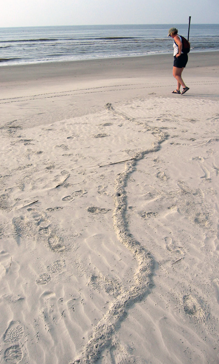
What is this long, meandering ridge making its way through a beach to the high tide mark on Sapelo Island, Georgia, and what made it? If you’re curious, please read on. But if you already know what it is, then you know a lot more than I did the first time I saw something like this. (Photograph by Anthony Martin.)

The last of those three scenarios happened to me on Sapelo Island, Georgia, in June 2004. My wife Ruth was with me, and we had just arrived on the island the previous afternoon, having stayed overnight at the University of Georgia (Athens) Marine Institute, or UGAMI. We decided that our first full morning in the field would be at Nannygoat Beach on the south end of Sapelo, which is a 5-minute drive or a 20-minute walk from the UGAMI.

We drove a field vehicle there (the gas gauge and everything else worked), parked, and took the boardwalk over the coastal dunes. Our elevated view from the boardwalk afforded a good look at many insect, ghost crab, bird, and mammal tracks made in the early morning. Circular holes punctured the dunes, made by ghost crabs (Ocypode quadrata). Sand aprons composed of still-moist sand were next to these burrow entrances, bearing crisply defined ghost-crab tracks, although early-morning sea breezes had already started to blur these.

At some point after walking onto the beach, though, we saw traces that we had not noticed in previous visits to Sapelo, and ones I have rarely seen there or on other Georgia barrier islands since. These oddities were meters-long, slightly sinuous to meandering ridges, about 15-20 cm (6-8 in) wide, extending in the sandy areas from the dunes through the berm and down to the high-tide mark, where they ended abruptly.

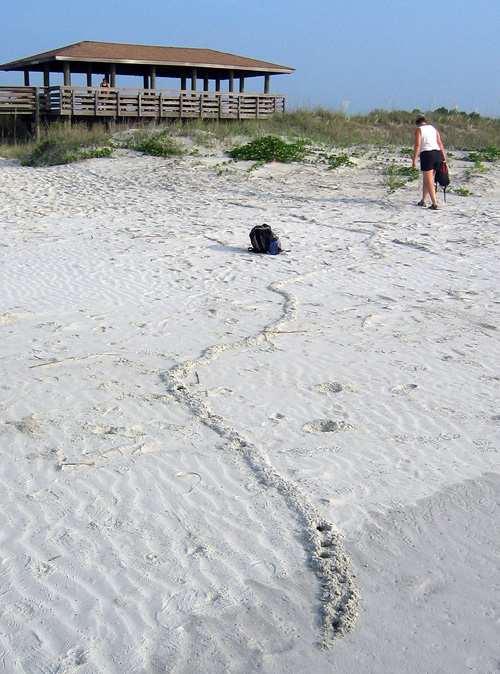
Same meandering ridge shown in the first photo, but viewed from the high-tide mark, showing how it connects with the primary dunes. Note how a few holes are punched in the part near me: more about those soon. (Photograph by Anthony Martin, taken on Sapelo Island, Georgia. P.S.: My wife Ruth is the scale in both photos, fulfilling one of the top 10 signs that I might be a geologist.)

Although a few ridges crossed one another, they rarely branched, and if they did, the branches were quite short, only about 10-15 cm (4-6 in). When we followed them to the dunes, they seemed to originate from some unseen place below the sandy surfaces. We investigated further by cutting through some of the ridges to see what they looked like inside. They turned out to be mostly open tunnels with circular cross sections about 5 cm (2 in) wide, slightly wider than a U.S. dollar coin. They were mostly hollow, and only occasionally did we encounter a plug of sand interrupting tunnel interiors. This supposition was backed up by ridges that had collapsed into underlying voids. A few of the ridges stopped with a rounded end the same diameter as the ridge, or as a larger, raised, elliptically shaped “hill.”

Ridge with quite a bit of meander in it. Check out the short branch toward the top right, where the tracemaker must have changed its mind and backed up, then continued digging toward the viewer. Scale = 15 cm (6 in). (Photograph by Anthony Martin, taken on Sapelo Island, Georgia.)

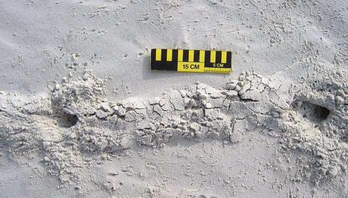
Two separate ridges intersecting, caused by one crossing the other, resulting in “false branching.” Also notice the partial collapse of sand into underlying hollow tunnels and how one of the ridges ends in a rounded mound. Scale = 15 cm (6 in). (Photograph by Anthony Martin, taken on Sapelo Island, Georgia.)

A short ridge ending in a raised, elliptical “hill,” connected to a partially collapsed tunnel that is not otherwise evident as an elevated surface. Same scale as before. (Photograph by Anthony Martin, taken on Sapelo Island, Georgia.)

Ruth and I agreed that these tunnels were burrows, instead of some random features made by the winds, tides, or waves. But by what? Clearly their makers were impressive burrowers, capable of digging through meters of sand. Their bodies also were probably just a little narrower than the burrow interiors, which helped us to think about body sizes. Then we considered where we were – dunes and beach – and what animals were the most likely ones to burrow in these environments.

A process of elimination – determining what they were not – was a good way to start figuring out their potential makers. For example, no way these burrows were from insects, such as beetle larvae, ant lion larvae, or mole crickets, because they were just too big. Insects also have a tough time handling salinity, so once they got to the surf zone with its saturated, saline sand, they would have had problems, or (more likely) an aversive reaction and turned around immediately instead of plowing ahead.

Insect burrow in coastal dune sand, made by a small beetle. Look at both the form and scale, and you’ll see this is not a match for what we were seeing. Scale in centimeters. (Photograph by Anthony Martin, taken on Cumberland Island, Georgia.)

Small mammals, like beach mice (Peromyscus polionotus), didn’t seem like good candidates either. Beach-mouse burrows are totally different from what we were seeing, and their burrows do not run all of the way down to the intertidal zone. Mice, like insects, also don’t like marine-flavored water; even if they might be able to temporarily tolerate it, they wouldn’t continue to burrow through moist, salty sand.

A beach-mouse burrow, with their tracks coming and going. Either the mice dug this burrow, or they occupied an abandoned ghost-crab burrow. Regardless, this also doesn’t match our mystery traces. Scale in millimeters. (Photograph by Anthony Martin, taken on Little St. Simons Island, Georgia.)

This led to an initial hypothesis that these burrows were from one of the most common larger burrowing animals in the area, and one comfortable in dune, berm, and beach environments with saturated, salty sand. These could only be from ghost crabs, I thought, an explanation supported by undoubted ghost crab burrows that perfectly intersected these tunnels, accompanied by undoubted ghost-crab tracks.

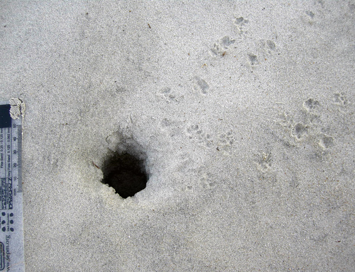
Ghost-crab burrows intersecting tunnels, accompanied by lots of ghost-crab tracks. Wow, that’s really convincing circumstantial evidence, wouldn’t you say? (Photograph by Anthony Martin, taken on Sapelo Island, Georgia.)

End of story, right? Well, no. I and a lot of other scientists have said this before, but it bears repeating: part of how science works is that in its practice we do not prove, we disprove. I somehow knew the “ghost crab burrowing horizontally through meters of sand from the dunes to the beach” hypothesis was a shaky one, and it bothered me that it just didn’t seem right. So I started reading as much as possible about ghost-crab burrowing behaviors. I thought I already knew a lot about this subject, but nonetheless was willing to acknowledge that there might be some holes in my learning (get it – holes?) that needed filling (get it – filling? Oh, never mind).

The gentle reader probably surmised what happened next. That’s right: not a single peer-reviewed reference mentioned ghost crabs digging meters-long shallow tunnels from the dunes to the beach. So either I was wrong, or I had documented a previously unknown and spectacular tracemaking behavior in this very well-studied species. A single cut by Occam’s Razor simply said, “You’re wrong.”

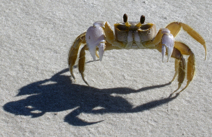
You thought I made long horizontal burrows that go all of the way from the dunes to the surf zone? Wow, you primates are dumber than I thought. (Photograph by Anthony Martin, taken on Sapelo Island, Georgia.)

If not a ghost crab then, what else could make meters-long horizontal burrows of the diameter we had seen? This is when I began to reconsider my original rejection of moles as possible tracemakers.

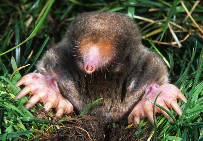
So what am I: chopped liver? (Photograph from Kenneth Catania, Vanderbilt University, and taken from Wikipedia.org here.)

Here’s what was the most interesting about this mistaken interpretation: it was made because of where we were. In other words, our initial mystification about these traces stemmed from their environmental context. Had we seen these burrows winding down a sandy road in the middle of a maritime forest on Sapelo Island, we would not have hesitated to say the word “mole.” Yet because we saw exactly the same types of burrows in coastal dunes and beaches, we said, “something else.”

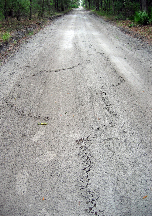
A long, meandering mole burrow in the sandy road going through a maritime forest on the north end of Sapelo Island. So if you see a burrow like this in the forest, you instantly say “mole.” But if you see it on the beach, you say, “Um, uh, duh…must be something else!” My tracks (size 8 1/2, mens) and 15 cm (6 in) photo scale for, well, scale. (Photograph by Anthony Martin.)

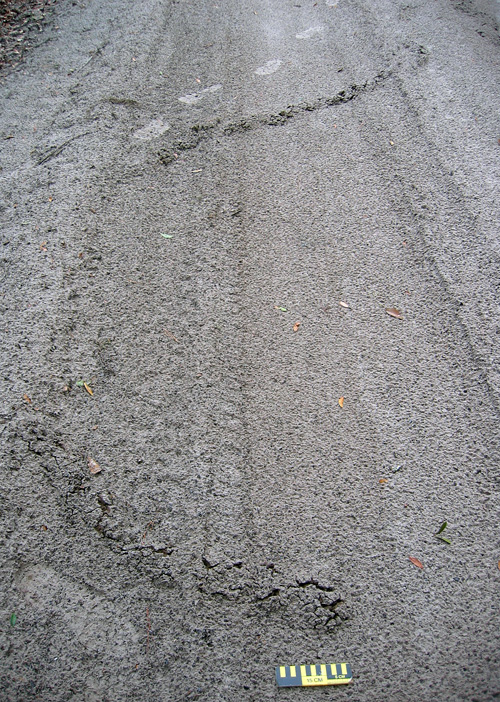
Another long, meandering ridge ended in a rounded “hill,” a trace that no one would hesitate to call a mole burrow, especially because it’s in the middle of a maritime forest. (Photo by Anthony Martin, taken on Sapelo Island, Georgia.)

A trip back to the literature further confirmed the mole hypothesis while also serving up a big slice of humble pie. I was embarrassed to find that these same burrows were described and interpreted as mole burrows in an article published in 1986. Even more mortifying: my dissertation advisor (Robert “Bob” Frey) was the first author on the article; it had been published while I was doing my dissertation work with him; and I had read the article years ago, but didn’t remember the part about mole traces. It was like these burrows were saying to me, “Go back to school, young man.”

OK, so these are mole burrows. Case closed. Now that we’ve identified them, we can stop thinking about them, and go on to name something else. But that ain’t science either, is it? This one answer – mole burrows – actually inspires a lot of other questions about them, which could lead to heaps more science:

Which moles made these burrows? The Georgia barrier islands have two documented species of moles, the eastern mole (Scalopus aquaticus) and star-nosed mole (Condylura cristata). Of these two, eastern moles are relatively common on island interiors, whereas star-nosed moles are either rare or locally extinct from some of the islands. But star-nosed moles are also more comfortable next to water bodies and seek underwater prey. So could these traces actually signal the presence of star-nosed moles in dune and beach environments? Frey and his co-author, George Pemberton, originally interpreted these as eastern mole burrows, but they also didn’t eliminate the possibility of star-nosed moles as the tracemakers, either.

What is the evolutionary history of moles on the Georgia barrier islands? Are these moles descended from populations isolated from mainland ones 10,000 years ago by the post-Pleistocene sea-level rise, or do they represent more modern stock that somehow made its way to the islands? A genetic study would probably resolve this issue, but who the heck is going to compare the genetic relatedness of moles from the Georgia barrier islands to those on the mainland?

What were they eating? Moles don’t just burrow for the exercise, but for the food. While burrowing, they are also voraciously chowing down on any invertebrate they encounter in the subsurface. But what would they eat in beach sands? As many shorebirds know, Georgia beaches are full of yummy amphipods, which would likely more than substitute for a mole’s typical earthworm and insect-filled diet in terrestrial environments. Yet as far as I can find in the scientific literature, no one has documented mole stomach contents or scat from coastal environments to test whether these small crustaceans are their main prey or not.

What happened to these moles once their burrows got to the surf zone? Did they turn around and burrow back, or did they go for a swim in the open ocean? The latter is actually not so far fetched, as moles are excellent swimmers, especially star-nosed moles. But how often would they do this?

Just how common (or rare) are these burrows in beaches? Just because I just perceive these burrows as rare could be an example of sample bias. Yes, I wrote an entire book about Georgia-coast traces and tracemakers and have done field work on the islands since 1998. But I don’t live on the Georgia barrier islands, nor have I spent more than a week continuously on any of them. Keenly observant naturalists who live on the islands or otherwise spend much time there could better answer this question than me. I suspect they’re actually much more common than I originally supposed, and now look for them to photograph or otherwise document whenever I go back to any of the islands.

Would such burrows preserve in the geologic record? Probably so, especially if they were made in dunes and filled with a differently colored or textured sand. But I’ll bet that nearly every paleontologist or geologist would make the same mistake I did, and reach for a burrowing marginal-marine crab or some other invertebrate as the tracemaker.

Geologists would be further fooled if fossil mole tunnels were intersected by genuine ghost-crab burrows, which would constitute a great example of a composite trace made by more than one species of animal. But why did the crabs burrow into the mole tunnels? Because it was easier. After all, the moles left hollow spaces and loosened sand over wide areas, practically begging ghost crabs to exploit these disturbed areas.

Anyway, I doubt many geologists would think of a small terrestrial mammal as a tracemaker for such burrows in sedimentary rocks formed in marginal-marine environments, although I’d love to be proved wrong on this. I’m hoping my writing about it here will help to prevent such confusion, and that whoever benefits from it will buy me an adult beverage as thanks.

In summary, this example of making a crab burrow out of a mole tunnel thus serves as a cautionary tale of how where we are when making observations in the field can influence our perceptions. But it also goes to show us how our wonderment with what we observe in natural environments can be renewed and encouraged by daring to be wrong once in a while, and learning from those mistakes.

Further Reading

Frey, R.W., and Pemberton, S.G. 1986. Vertebrate lebensspuren in intertidal and supratidal environments, Holocene barrier island, Georgia. Senckenbergiana Maritima, 18: 97-121.

Gorman, M.L., and Stone, R.D. 1990. The Natural History of Moles. University of Chicago Press, Chicago, Illinois: 138 p.

Harvey, M.J. 1976. Home range, movement, and diel activity of the eastern mole, Scalopus aquaticus. American Midland Naturalist, 95: 436-445.

Henderson, R.F. 1994. Moles. Prevention and Control of Wildlife Damage, Paper 49, University of Nebraska, Lincoln: D51-58. (Entire text here.)

Hickman, G.C. 1983. Influence of the semiaquatic habit in determining burrow structure of the star-nosed mole (Condylura cristata). Canadian Journal of Zoology, 61: 1688-1692.

Life Traces as Cover Art

I’ve been a long-time admirer of the artistic appeal of tracks, trails, burrows, nests, and other traces of animal behavior. My fondness for the beauty of traces also no doubt contributes to my science: after all, the longer I look at a trace, the more I learn about it. This sentiment accords with a long-time principle of paleontology, botany, and other facets of natural history, which is, “If you draw it, you know it,” with the added benefit of expressing your appreciation of natural objects to others through visual depictions.

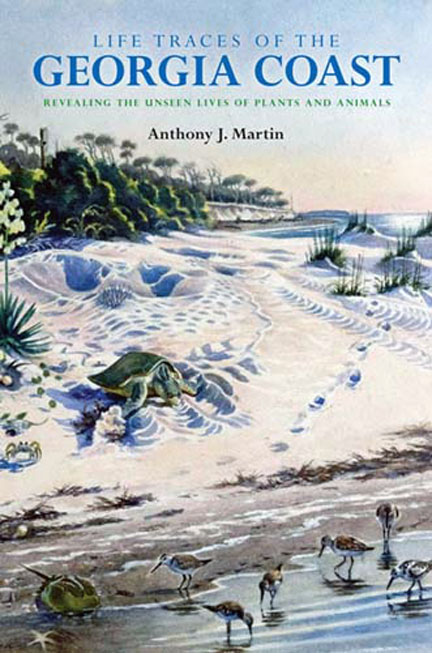
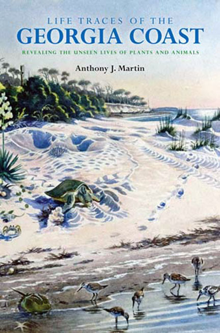
Here it is: the cover for my upcoming book, Life Traces of the Georgia Coast: Revealing the Unseen Lives of Plants and Animals! The book is scheduled to be published by Indiana University Press in the fall of 2012, so be watching out for it then. But in the meantime, look at the beautiful cover art. Who created it, what inspired it, and what science lies behind its aesthetically pleasing composition? Please read on to find out.

My thinking about traces as objects of art is not very original, though, and in fact has been preceded by most of humanity. For example, animal tracks and other traces were common subjects of rock art extending back to the Pleistocene Epoch. Whether made as pictographs or petroglyphs, these traces of traces are in Australia, southern Africa, Australia, and Europe, with some tens of thousands of years old. Based on this tantalizing evidence, one could reasonably propose that the representation of animal traces through art composes an intrinsic part of our heritage as a species. Yes, I know, that’s a tough hypothesis to pursue any further. So I’ll leave it to my paleoanthropologist colleagues to work out (or not).

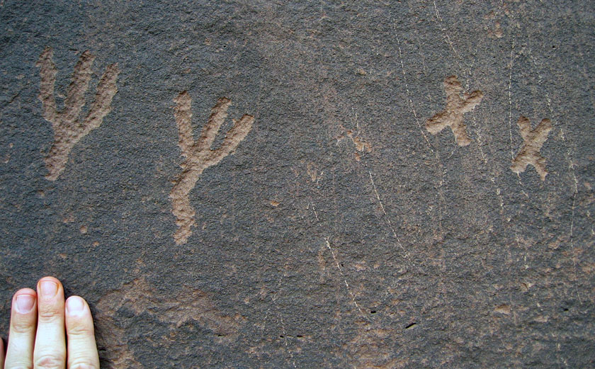
Petroglyphs that likely represent bird tracks, etched in Triassic sandstone by Native Americans hundreds of years ago (sorry, I’m a paleontologist, not an archaeologist). The pair of marks on the right is similar to the tracks made by a perching bird with three forward pointing toes and one rearward-pointing toe – such as an eagle – whereas those to the right may be like those of a roadrunner, which has an X-shaped foot. Petroglyphs are in northeastern Arizona, near Petrified Forest National Park.

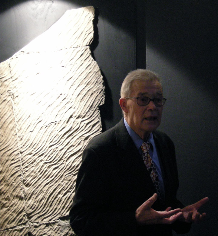
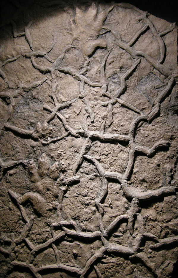
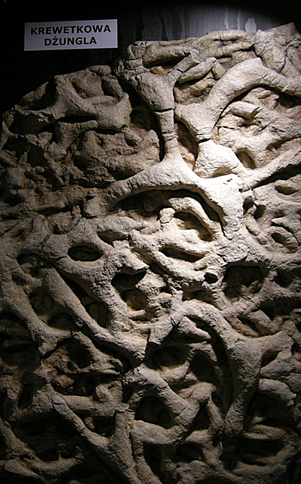
Much more recently, trace fossils similarly inspired renowned ichnologist Dolf Seilacher, who also saw these vestiges of past behavior as lovely objects that fill us with wonder. As a result, in the mid-1990s, he conceived of a traveling exhibit and book showcasing tableaus of trace fossils and other sedimentary structures, titled Fossil Art. For this show – embraced by natural-history venues but mostly rejected by art museums – Seilacher prepared it by: (1) making latex molds of sedimentary rock surfaces; (2) pouring epoxy resin into the molds to make casts mimicking the original bedding planes; and (3) using indirect lighting to enhance details; and (4) assigning creative titles to each piece as if they were works of art.

So these artificial slabs are not human-made art in the traditional sense, but nonetheless invoke marvel, project splendor, and otherwise make us think, engaging the same senses and thought processes that accompany an appreciation of art. Moreover, the slim book Seilacher authored for the exhibit contains explanatory text about each of the objects, illuminated further by his marvelous illustrations and visual interpretations. I remember first seeing a version of this exhibit in Holzmaden, Germany in 1995, near Seilacher’s home in Tubingen, and most lately enjoyed strolling through it with other many ichnologists – and Seilacher himself – in Krakow, Poland in 2008.

World-renowned ichnologist and (oh yeah) Crafoord Prize winner, Dolf Seilacher, lecturing about the planning and execution of Fossil Art as an exhibit while it was showing at the Geological Museum of Jagiellonian University in Krakow, Poland in September 2008. Photograph by Anthony Martin.

A close-up of Wrong Sided Hands, one of the pieces displayed in Fossil Art, cast from a latex mold of a sample from Lower Triassic Buntsandstein of Germany. The piece is so-called because the false appearance of a “thumb” on the outside of the tracks originally led to the mistaken idea that the animal awkwardly crossed its own path with each step. This turned out to be wrong. Also, check out the mudcracks! Photograph by Anthony Martin.

Another close-up of a piece from Fossil Art, titled Shrimp Burrow Jungle (helpfully translated into Polish here). This one is based on burrow systems made by crustaceans during the Late Triassic in Italy, which became densely populated over time and hence contributed to overlapping systems. Photograph by Anthony Martin.

Hence during my writing of a book about the modern traces of the Georgia barrier islands, I was well aware of how some of these traces could likewise lend to artistic expression. Some of this mindfulness was applied to a collaborative artwork done with my wife, Ruth Schowalter, in which we took an illustration of mine from the book and used it as the inspiration for a large watercolor painting depicting traces that would form with rising sea level along the Georgia coast (discussed in detail here).

Nonetheless, it was especially important to think about traces as art when considering a potential cover for the book. Book authors know all too well that a well-designed, attractive cover is essential for grabbing the attention of a potential reader, so I had that practical consideration in mind. But I also wanted a cover that pleased me personally, sharing my love of beautiful traces with others, especially those varied and wondrous tracks, burrows, and trails I had seen and studied on the Georgia barrier islands during the past 15 years.

In such an endeavor, I also faced the added pressure of precedence set by my publisher, Indiana University Press. My book is part of a series by IU Press, called Life of the Past, which is widely admired not only for its comprehensive coverage of paleontological topics, but also for its fine cover art, showcasing works done by a veritable “who’s who” of “paleoartists,” So I knew the cover art for my book needed to both conform to this legacy of artistic excellence, but also stand out from other books in the series because of its unique themes. After all, this would be first book in Life of the Past focusing specifically on ichnology. Moreover, the book is more concerned on modern tracemakers and their environments, rather than plants and animals of pre-human worlds. This was done with the intention of demonstrating how our knowledge of modern traces helps us to better understand life from the geologic past, an intrinsic principle of geology called uniformitarianism.

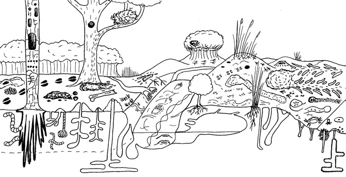
Ideally, as an ichnological purist, I would have had a cover devoid of any animals, and just shown environments of the Georgia of the Georgia coast with their traces. Indeed, I did just that in some of my illustrations in the book, in which I purposefully omitted animals and left only their traces. This “ichno-centric” mindset actually serves a pedagogical purpose, in that it would echo the truism that many sedimentary rocks are devoid of body fossils, yet are teeming with trace fossils.

Figure 1.3 from Life Traces of the Georgia Coast, conveying a sense of the variety and abundance of traces on a typical Georgia barrier island, from maritime forest (left) to shallow intertidal (right). I purposefully drew this illustration using a more cartoonish technique to introduce broad search images of traces for people who may not ordinarily think about these. But also notice what’s missing from the figure: the animal tracemakers. Instead, only immobile plants are depicted. Would this make for good cover art? No and no, especially if you’ve seen the typical covers done for Indiana University Press books. Illustration by Anthony Martin.

Realistically, though, I also knew that modern traces, particularly those made in places as easy to visit as parts of the Georgia coast, would be more eye-catching if accompanied by some of their charismatic tracemakers in a beautiful, natural setting. After all, the Georgia coast has lengthy sandy beaches, dunes, maritime forests, and salt marshes, inhabited by a wide variety of animals, such as sea turtles, shorebirds, alligators, horseshoe crabs, ghost crabs, and many others.

I also knew that a paleoartist would not be as well suited to the task of creating a cover as someone who works more with modern environments. A better pick would be someone who was familiar with the landscapes, plants, and animals of the Georgia barrier islands, but also a fine artist. I briefly toyed with the idea of doing it myself, but already felt like far too much of the book had been “DIY,” and was not confident enough in my skills to put together a compelling cover in enough time before the book came together. An artfully done photograph was another possibility, so I sent several prospective examples to the editors for their appraisal, but these were all shot down for not having enough aesthetic elements for an attention-getting cover (i.e., traces + landscapes + sky + water = very difficult to get into a single photo).

Fortunately, through social connections that still happen despite the Internet and its incentives for becoming increasingly introverted, I met Alan Campbell through mutual friends in December 2008 at a dinner party on the Georgia coast. Fortuitously enough, our meeting was also just before Ruth and I did three weeks of field work on the barrier islands for the book. It was only fitting, then, that our first meeting was spent dining with both of us facing a Georgia salt marsh, filled with fiddler crab burrows and other such traces. Alan is a Georgia artist with much life experience along its coast, he has often portrayed its environments through gorgeous watercolors, and he has worked with scientists in the field.

Consequently, I kept Alan in mind as a potential cover artist for the next few years, and after I had finished the text and all figures for the book, I contacted him last year about my idea, while simultaneously suggesting him to the editors at IU Press. After much back-and-forth negotiations, with me in the middle, both parties finally came to an agreement, and Alan had a contract to do the artwork for the cover by December 2011.

To help Alan in researching his task, I sent him all of my illustrations and photos used in the book so that he would have an extensive library of trace images on hand for reference. He also had this blog as a source, in which I regularly write about Georgia-coast traces, explanations that are always accompanied by photographs and an occasional illustration. We also exchanged many e-mails and talked on the phone whenever needed. I told Alan my preferred cover would feature a coastal scene, but one filled with traces. He voiced a concern that the painting might become too “busy,” and the details might be lost in reduction of the image to the size

Alan’s contract specified that he would have preliminary study sketches would be done by February 1, and the final cover art was to be finished by March 30. He was only a little late with the study sketches (delayed by a minor operation), and I was delighted to see the following sketch in mid-February.

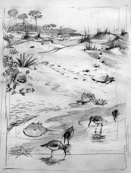
Study sketch by Alan Campbell for the cover of Life Traces of the Georgia Coast. Reprinted with his permission, and anyone else who want to use it, you have to ask him, too. By the way, every time you use original artwork without permission, a little kitten dies.

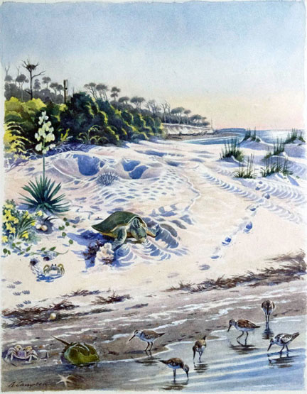
After a little bit of feedback from both me and graphic designers at IU Press, Alan went back to the drawing board (so to speak), and came up with the following watercolor painting.

Life Traces of the Georgia Coast, 2012, watercolor on paper, 14” X 18” by Alan Campbell. Again, if you want to use it, you have to ask him first and get permission. Remember those kittens? They’re alive now, but there’s no guarantee they’re going to stay that way.

I gave this artwork a big thumbs up, as did the people at IU Press. So once approved and the scan was sent to IU Press, it was up to the graphic designers there to pick out the typeface, color of the type for the main title, subtitle, author name, and placement of type without covering up the main composition of the painting. I had no say in this, and that’s a good thing, because they really knew what they were doing. It is a very nicely designed cover, and the only thing that would please me more is if they had produced a holographic image of it. (Maybe next year.)

The final cover art for Life Traces of the Georgia Coast revisited. Does it look a little different, now that you know more about how it came about?

I won’t spoil the fun for potential readers, scientists, and art appreciators by explaining in detail all of the ichnological, ecological, and geological elements incorporated into the cover. After all, I’d like to sell a few copies of the book, while also letting readers make their own personal discoveries. But hopefully all of you now have a better appreciation for how traces made by animals, our recognition and admiration for these, and artistic expression of them can all combine to contribute to a book that can be accurately judged by its cover.

Further Reading

Leigh, J., Kilgo, J., and Campbell, A. 2004. Ossabaw: Evocations of an Island. University of Georgia Press, Athens, Georgia.

Martin, A.J., in press. Life Traces of the Georgia Coast: Revealing the Unseen Lives of Plants and Animals. Indiana University Press, Bloomington, Indiana.

Morwood, M.J. 2002. Visions from the Past: The Archaeology of Australian Aboriginal Art. Allen & Unwin, Sydney, Australia.

Seilacher, A. 2008. Fossil Art: An Exhibition of the Geologisches Institut. Tubingen University, Tubingen, Germany.

Tomaselli, K.G. 2001. Rock art, the art of tracking, and cybertracking: Demystifying the “Bushmen” in the information age. Visual Anthropology, 14: 77-82.


Into the Dragon’s Lair: Alligator Burrows as Traces

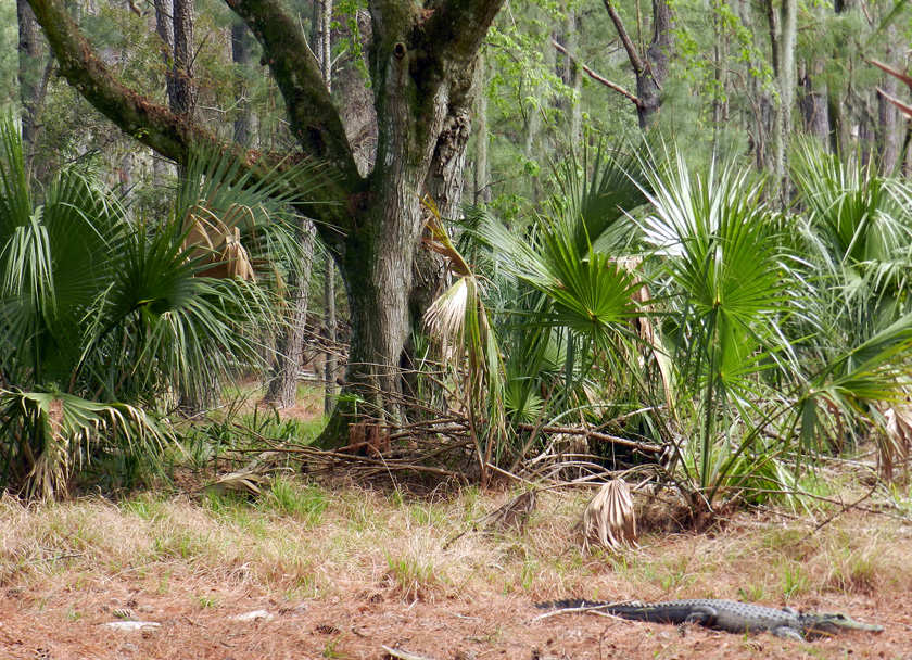
American alligators (Alligator mississippiensis) tend to provoke strong feelings in people, but the one I encounter the most often is awe, followed closely by fear. Both emotions are certainly justifiable, considering how alligators are not only the largest reptiles living on the Georgia barrier islands, but also are the top predators in both freshwater and salt-water ecosystems in and around those islands. I’ve even encountered them often enough in maritime forests of the islands to regard them as imposing predators in those ecosystems, too.

Time for a relaxing stroll through the maritime forest to revel in its majestic live oaks, languid Spanish moss, and ever-so-green saw palmettos. Say, does that log over there look a little odd to you? (Photo by Anthony Martin, taken on St. Catherines Island.)

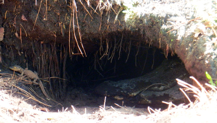
But what many people may not know about these Georgia alligators is that they burrow. I’m still a little murky on exactly how they burrow, but they do, and the tunnels of alligators, large and small, are woven throughout the interiors of many Georgia barrier islands. Earlier this week, I was on one of those islands – St. Catherines – having started a survey of alligator burrow locations, sizes, and ecological settings.

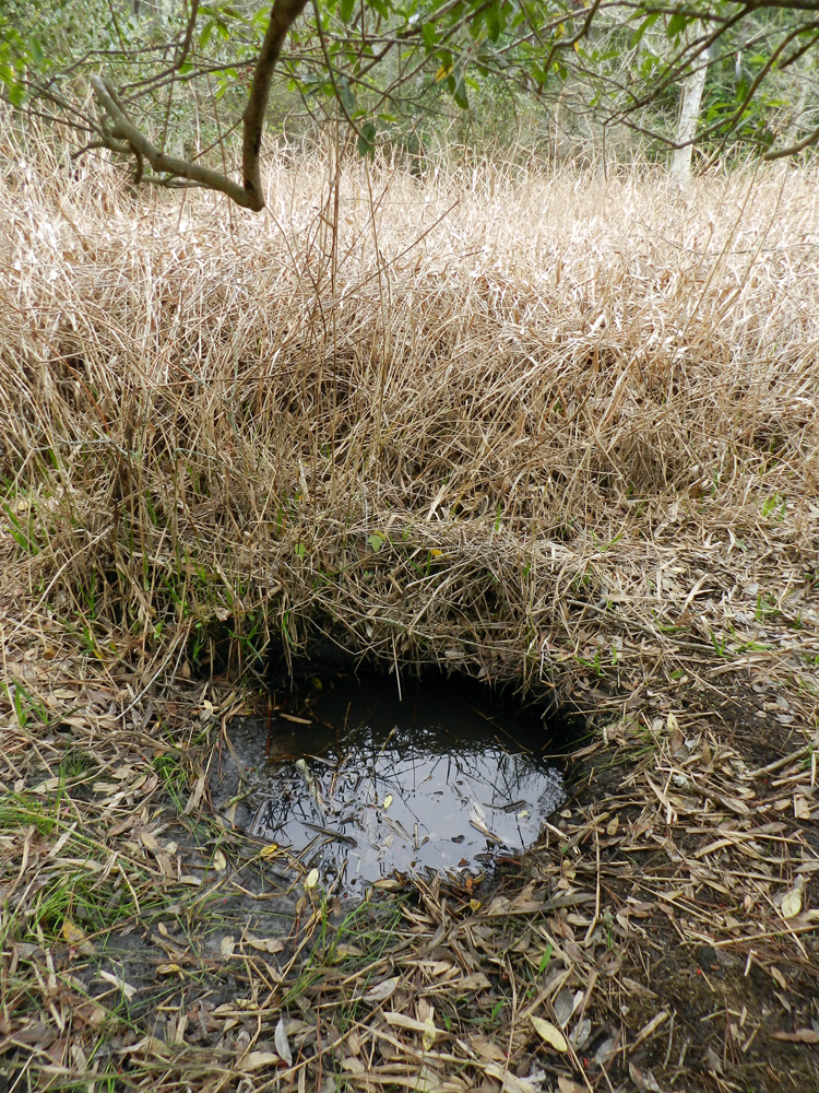
Entrance to an alligator burrow in a former freshwater marsh, now dry, yet the burrow is filled with water. How did water get into the burrow, and how does such traces help alligators to survive and thrive? Please read on. (Photograph by Anthony Martin and taken on St. Catherines Island, Georgia.)

In this project, I’m working cooperatively (as opposed to antagonistically) with a colleague of mine at Emory University, Michael Page, as well as Sheldon Skaggs and Robert (Kelly) Vance of Georgia Southern University. As loyal readers may recall, Sheldon and Kelly worked with me on a study of gopher tortoise burrows, also done on St. Catherines Island, in which we combined field descriptions of the burrows with imaging provided by ground-penetrating radar (also known by its acronym, GPR). Hence this project represents “Phase 2” in our study of large reptile burrows there, which we expect will result in at least two peer-reviewed papers and several presentations at professional meetings later this year.

Why is a paleontologist (that would be me) looking at alligator burrows? Well, I’m very interested in how these modern burrows might help us to recognize and properly interpret similar fossil burrows. Considering that alligators and tortoises have lineages that stretch back into the Mesozoic Era, it’s exciting to think that through observations we make of their descendants, we could be witnessing evolutionary echoes of those legacies today.

Indeed, for many people, alligators evoke thoughts of those most famous of Mesozoic denizens – dinosaurs – an allusion that is not so farfetched, and not just because alligators are huge, scaly, and carnivorous. Alligators are also crocodilians, and crocodilians and dinosaurs (including birds) are archosaurs, having shared a common ancestor early in the Mesozoic. However, alligators are an evolutionarily distinct group of crocodilians that likely split from other crocodilians in the Late Jurassic or Early Cretaceous Period, an interpretation based on both fossils and calculated rates of molecular change in their lineages.

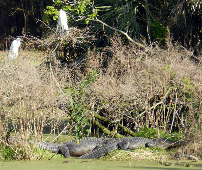
Archosaur relatives, reunited on the Georgia coast: great egrets (Ardea alba), which are modern dinosaurs, nesting above American alligators (Alligator mississippiensis), which only remind us of dinosaurs, but shared a common ancestor with them in the Mesozoic Era. (Photograph by Anthony Martin, taken on St. Catherines Island, Georgia.)

Along these lines, I was a coauthor on a paper that documented the only known burrowing dinosaurOryctodromeus cubicularis – from mid-Cretaceous rocks in Montana. In this discovery, we had bones of an adult and two half-grown juveniles in a burrow-like structure that matched the size of the adult. I also interpreted similar structures in Cretaceous rocks of Victoria, Australia as the oldest known dinosaur burrows. Sadly, these structures contained no bones, which of course make their interpretation as trace fossils more contentious. Nonetheless, I otherwise pointed out why such burrows would have been likely for small dinosaurs, especially in Australia, which was near the South Pole during the Cretaceous. At least a few of these reasons I gave in the published paper about these structures were inspired by what was known about alligator burrows.

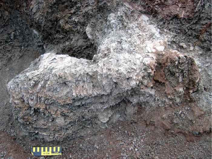
Natural sandstone cast of the burrow of the small ornithopod dinosaur, Oryctodromeus cubicularis, found in Late Cretaceous rocks of western Montana; scale = 15 cm (6 in). (Photograph by Anthony Martin, taken in Montana, USA.)

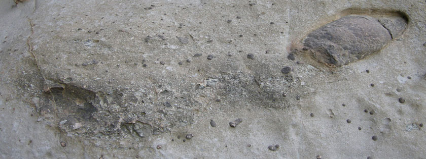
Enigmatic structure in Early Cretaceous rocks of Victoria, Australia, interpreted as a small dinosaur burrow. It was nearly identical in size (about 2 meters long) and form (gently dipping and spiraling tunnel) to the Montana dinosaur burrow. (Photograph by Anthony Martin, taken in Victoria, Australia.)

What are the purposes of modern alligator burrows? Here are four to think about:

Dens for Raising Young Alligators – Many of these burrows, like the burrow interpreted for the dinosaur Oryctodromeus, serve as dens for raising young. In such instances, these burrows are occupied by big momma ‘gators, who use them for keeping their newly hatched (and potentially vulnerable) offspring safe from other predators.

Two days ago, Michael and I experienced this behavioral trait in a memorable way while we documented burrow locations. As we walked along the edge of an old canal cutting through the forest, baby alligators, alarmed by our presence, began emitting high-pitched grunts. This then provoked a large alligator – their presumed mother – to enter the water. Her reaction effectively discouraged us from approaching the babies; indeed, we promptly increased our distance from them. (Our mommas didn’t raise no dumb kids.) So although we were hampered in finding out the exact location of this mother’s den, it was likely very close to where we first heard the grunting babies. I have also seen mother alligators on St. Catherines Island usher their little ones through a submerged den entrance, quickly followed by the mother turning around in the burrow and standing guard at the front door.

Oh, what an adorable little baby alligator! What’s that? You say your mother is a little over-protective? Oh. I see. I think I’ll be leaving now… (Photograph by Anthony Martin, taken on St. Catherines Island.)

Temperature Regulation – Sometimes large male alligators live by themselves in these burrows, like some sort of saurian bachelor pad. For male alligators on their own, these structures are important for maintaining equitable temperatures for these animals. Alligators, like other poikilothermic (“cold-blooded”) vertebrates, depend on their surrounding environments for controlling their body temperatures. Even south Georgia undergoes freezing conditions during the winter, and of course summers there can get brutally hot. Burrows neatly solve both problems, as these “indoor” environments, like caves, provide comfortable year-round living in a space that is neither too cold nor too hot, but just right. The burrowing ability of alligators thus makes them better adapted to colder climates than other crocodilians, such as the American crocodile (Crocodylus acutus), which does not make dwelling burrows and is restricted in the U.S. to the southern part of Florida.

Protection against Fires – Burrows protect their occupants against a common environmental hazard in the southeastern U.S., fire. This is an advantage of alligator burrows that I did not appreciate until only a few days ago while in the field on St. Catherines. Yesterday, the island manager (and long-time resident) of St. Catherines, Royce Hayes, took us to a spot where last July a fire raged through a mixed maritime forest-freshwater wetland that also has numerous alligator burrows. The day after the fire ended, he saw two pairs of alligator tracks in the ash, meaning that these animals survived the fire by seeking shelter, and further reported that at least one of these trackways led from a burrow. The idea that these burrows can keep alligators safe from fires makes sense, similar to how gopher tortoises can live long lives in fire-dominated long-leaf pine ecosystems.

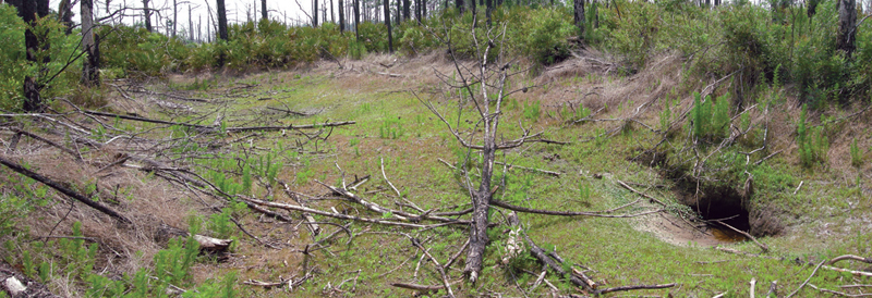
An area in the southern part of St. Catherines Island, scorched by a fire last July, that is also a freshwater wetland inhabited by alligators with burrows. The burrow entrances are all under water right now, which would work out fine for their alligator occupants if another fire went through there tomorrow. (Photograph by Anthony Martin, taken on St. Catherines Island.)

• Protection against Droughts – Burrows also probably help alligators keep their skins moist during droughts. Because these burrows often intersect the local water table, alligators might continue to use them as homes even when the accompany surface-water body has dried up. We saw several examples of such burrows during the past few days, some of which were occupied by alligators, even though their adjacent water bodies were nearly dry.

For example, yesterday Michael and I, while scouting a few low-lying areas for either occupied or abandoned dens, saw a small alligator – only about a meter (3.3 ft) long – in a dry ditch cutting through the middle of a pine forest. Curious about where alligator’s burrow might be, we approached it to see where it would go. It ran into a partially buried drainage pipe under a sandy road, a handy temporary refuge from potentially threatening bipeds. Seeing no other opening on that side of the road, we then checked the other side of the road, and were pleasantly surprised to find a burrow entrance with standing water in it. This small alligator had made the best of its perilously dry conditions by digging down to water below the ground surface.

Alligator burrow (right) on the edge of a former water body. Notice how water is pooling in the front of the burrow, showing how it intersects the local water table. The entrance also had fresh alligator tracks and tail dragmarks at this entrance, showing that it was still occupied despite the lack of water outside of it. (Photograph by Anthony Martin, taken on Cumberland Island, Georgia.)

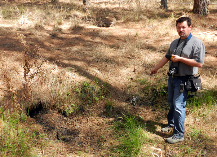
Alligator burrows (left foreground and middle background) in a maritime forest, also not associated with a wetland but marking the former location of one. Although the one to the left was unoccupied when we looked at it, it had standing water just below its entrance. This meant an alligator could have hung out in this burrow for a while after the wetland dried up, and it may have just recently departed. Also, once these burrows are high and dry, bones strewn about in front of them also add a delicious sense of dread. Here, Michael Page points at a deer pelvis, minus the rest of the deer. (Photograph by Anthony Martin, taken on St. Catherines Island, Georgia.)

What is especially interesting about the American alligator is how the only other species of modern alligator, A. sinensis in China, is also a fabulous burrower, digging long tunnels there too, which they use for similar purposes. This behavioral trait in two closely related but now geographically distant species implies a shared evolutionary heritage, in which burrowing provided an adaptive advantage for their ancestors.

Thus like many research problems in science, we won’t really know much more about alligator burrows until we gather information about them, test some of the questions and other ideas that emerge from our study, and otherwise do more in-depth (pun intended) research. Nonetheless, our all-too-short trip to St. Catherines Island this week gave us a good start in our ambitions to apply a comprehensive approach to studying alligator burrows. Through a combination of ground-penetrating radar, geographic information systems, geology, and old-fashioned (but time-tested) field observations, we are confident that by the end of our study, we will have a better understanding of how burrows have helped alligators adapt to their environments since the Mesozoic.

Juvenile alligators just outside two over-sized burrows, made and used by previous generations of older and much larger alligators. How might such burrows get preserved in the fossil record? How might we know whether these burrows were reused by younger members of the same species? Or, would we even recognize these as fossil burrows in the first place? All good questions, and all hopefully answerable by studying modern alligator burrows on the Georgia barrier islands. (Photograph by Anthony Martin, taken on Sapelo Island, Georgia.)

Further Reading

Erickson, G.M., et al. 2012. Insights into the ecology and evolutionary success of crocodilians revealed through bite-force and tooth-pressure experimentation. PLoS One, 7(3): doi:10.1371/journal.pone.0031781.

Martin, A.J. 2009. Dinosaur burrows in the Otway Group (Albian) of Victoria, Australia and their relation to Cretaceous polar environments. Cretaceous Research, 30: 1223-1237.

Martin, A.J., Skaggs, S., Vance, R.K., and Greco, V. 2011. Ground-penetrating radar investigation of gopher-tortoise burrows: refining the characterization of modern vertebrate burrows and associated commensal traces. Geological Society of America Abstracts with Programs, 43(5): 381.

St. John, J.A., et al., 2012. Sequencing three crocodilian genomes to illuminate the evolution of archosaurs and amniotes. Genome Biology, 13: 415.

Varricchio, D.J., Martin, A. J., and Katsura, Y. 2007. First trace and body fossil evidence of a burrowing, denning dinosaur. Proceedings of the Royal Society of London B, 274: 1361-1368.

Waters, D.G. 2008. Crocodlians. In Jensen, J.B., Camp, C.D., Gibbons, W., and Elliott, M.J. (editors), Amphibians and Reptiles of Georgia. University of Georgia Press, Athens, Georgia: 271-274.

Acknowledgements: Much appreciation is extended to the St. Catherines Island Foundation, which supported our use of their facilities and vehicles on St. Catherines this week, and Royce Hayes, who enthusiastically shared his extensive knowledge of alligator burrows. I also would like to thank my present colleagues and future co-authors – Michael Page, Sheldon Skaggs, and Kelly Vance – for their valued contributions to this ongoing research: we make a great team. Lastly, I’m grateful to my wife Ruth Schowalter for her assistance both in the field and at home. She’s stared down many an alligator burrow with me on multiple islands of the Georgia coast, which says something about her spousal support for this ongoing research.

Going Hog Wild on the Georgia Barrier Islands

(The following is the third part of a series about traces of invasive species of mammals on the Georgia barrier islands and the ecological effects of these traces. Here is an introduction to the topic, the first entry about the feral horses of Cumberland Island, and the second entry about the feral cattle of Sapleo Island.)

Anytime I hear someone refer to a Georgia barrier island as “pristine,” I wince a little bit, smile, and say, “Well, bless your heart.” The truth is, nearly every island on the Georgia coast, no matter how beautiful, is not in a pristine state, having been considerably altered by humans over the past 4,500 years, whether these were Native Americans, Europeans, or Americans. These varying degrees of change are sometimes subtle but nonetheless there, denoted by the loss of original habitats and native species or the addition of non-native species.

Still, one Georgia barrier island comes close to fulfilling this idealistic label: Wassaw Island, which during its 1,000-year geologic history somehow escaped commercial logging, agriculture, animal husbandry, and year-round settlements. Partially because of this legacy, Wassaw is designated as a National Wildlife Refuge, and is reserved especially for ground-nesting birds. One of the ways this island works well as a refuge for these birds is – as of this writing – its “hog free” status, a condition that can be tested with each visit by looking for the obvious traces of this invasive species.

The interior of Wassaw Island, with maritime forest surrounding a freshwater wetland created by alligators, the rightful owners of the island. On Wassaw, there are no tracks or signs of feral hogs, qualifying it as a “pristine” island. (Photograph by Anthony Martin.]
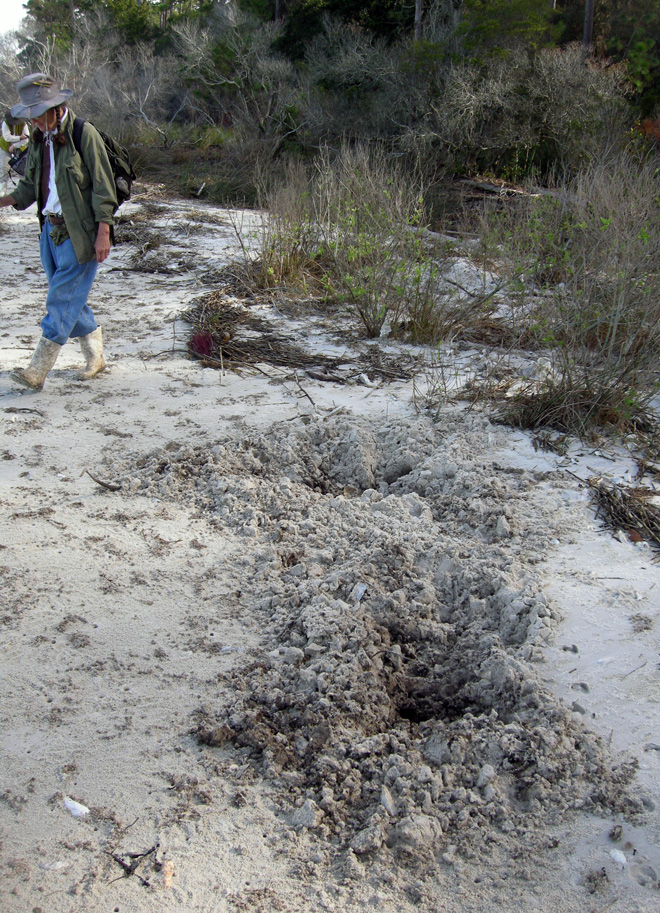
Contrast this with Cumberland Island National Seashore, where hogs run wild and freely. The huge pits here are in an intertidal zone of a beach on the northwest corner of the island. Naturalist Carol Ruckdeschel (background) for scale. (Photograph by Anthony Martin.)

Feral hogs (Sus scrofa) have a special place in the rogue’s gallery of invasive mammals on the Georgia barrier islands, and most people agree they are the worst of the lot. Hogs are on every large undeveloped island – Cumberland, Sapelo, St. Catherines, and Ossabaw – and they wreak ecological havoc wherever they roam. The widespread damage they cause is largely related to their voracious and omnivorous diet, in which they seek out and eat nearly any foodstuff, whether fungal, plant, or animal, live or dead. Their fine sense of smell is their greatest asset in this respect: every time I have tracked feral hogs, their tracks show head-down-nose-to-the-ground movement as the norm, punctuated by digging that uses a combination of their snouts and front hooves to tear up the ground in their quest for food. In other words, they generally act like, well, you know what.

Most importantly from the standpoint of native animals that try to live more than one generation beyond a single hog meal, feral hogs eat eggs. Hence ground-nesting birds and turtles are among their victims, and hogs are quite keen on eating sea turtle eggs. Mothers of all three species of sea turtles that nest on the Georgia coast – loggerhead (Caretta caretta), green (Chelonia mydas), and leatherback (Dermochelys coriacea) – dig subsurface nests filled with 100-150 eggs full of protein and other nutrients, making tempting targets for any free-ranging feral hogs. Similarly, hogs also threaten another salt-water turtle, the diamondback terrapin (Malaclemys terrapin); this turtle lays its eggs in shallow nests near the edges of salt marshes, which hogs manage to find. Conservation efforts to save diamondback terrapins from human predation have mostly succeeded (it used to be a tasty ingredient in soups), but hogs can’t read and don’t discriminate when it comes to eating eggs. Here is where feral hogs are particularly dangerous as an invasive species: unlike feral horses or cattle, which “merely” degrade parts of their ecosystems: feral hogs can contribute directly to the extinction of native species. As I often tell my students, if you want to cause a species to go extinct, stop it from reproducing.
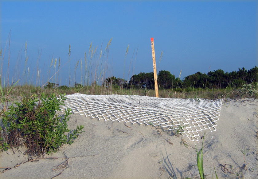
Sea-turtle nest on Sapelo Island, marked by a stake and protected by plastic fencing to prevent feral hog and raccoon depredation of its eggs. An individual raccoon would only eat about 1/3 of the eggs in a sea-turtle nest, whereas pigs would just keep on eating. (Photograph by Anthony Martin.)

As an ichnologist, though, what astounds me the most about these hogs is the extremely wide ecological range of their traces. I have seen their tracks – often made by groups traveling together – in the deepest interiors of maritime forests, in freshwater wetlands, and crossing back-dune meadows, high salt marshes, coastal dunes, and beaches. If their traces became trace fossils, paleontologists would refer to them as a facies-crossing species, in which facies (think “face”) are the identifiable traits of a sedimentary environment preserved in the geologic record. Based on their tracks and sign, they are ubiquitous in terrestrial and marginal-marine environments. Oh, and did I mention they are also good swimmers? Swimming across a tidal channel at low tide is an easy feat for them, enabling hogs to spread from island to island, without the assistance of humans.
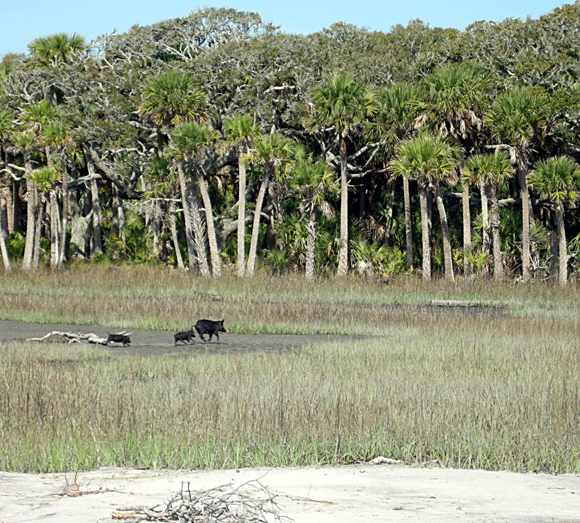
Run away, run away! Feral hogs in a St. Catherines Island salt marsh, consisting of two juveniles and an adult, do not stick around to see whether humans are going to shoot them; they just assume so. This sighting, along with their widespread tracks and other traces, show how feral hogs can occupy and affect nearly every environment on a Georgia barrier island. (Photograph by Anthony Martin.)

So to better understand why feral hogs are such successful invaders of the Georgia islands, it’s helpful to think about their evolutionary history. As expected, this history is complicated, just like that of any domesticated species in which selective breeding narrowed the genetic diversity we see today. About 15 subspecies of Sus scrofa have been identified, making its recent family tree look rather bushy. Based on genetic studies, divergence between wild species of Sus scrofa (so-called “wild boars”) and various subspecies may have happened as long ago as 500,000 years ago in Eurasia, although humans did not capture and start breeding them until about 9,000 years ago.
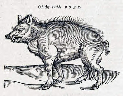
Depiction of a European wild boar from 1658, in The History of Four-Footed Beasts and Serpents by Edward Topsell. Original image from a woodcut, digital image in Wikipedia Commons here.

The closest extant relatives to these hogs native to North America are peccaries, which live in the southwestern U.S., Central America, and South America. However, peccaries are recent migrants to North America, and only one Pleistocene species (Mylohyus nasutus) is known from the fossil record of the eastern U.S. This means that the post-Pleistocene ecosystems of the eastern U.S., and especially those of the Georgia barrier islands, have never encountered anything like these animals. Also, unlike the feral horses of Cumberland Island and the feral cattle of Sapelo Island, the feral hogs of the Georgia barrier islands were likely introduced early in European colonization of the coast, and may have started with the Spanish in the 16th century.

Unfortunately, part of the selective breeding of Eurasian hogs was for early sexual maturity and large litter sizes. Female feral hogs can reach breeding age at 5 months, and litters typically have 4-8 piglets, but can be greater than 12; females also can produce three litters in just more than a year. Do the math, and that adds up to a lot of pigs in a short amount of time. Furthermore, on Georgia barrier islands with few year-round human residents, the only predation pressures young piglets face daily include raptors (no, not that kind of raptor) or alligators. This means young hogs reach sexual maturity soon enough to rapidly overrun a barrier island.
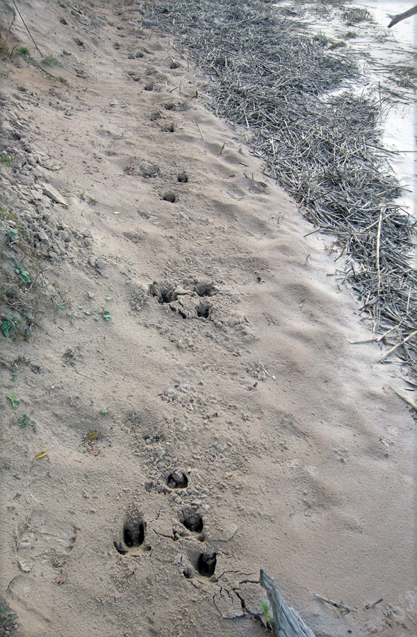
Feral hog trackway in a sandy intertidal zone of Cumberland Island, showing a typical gallop pattern (four tracks together –> space –> four tracks together), symbolizing how they are running roughshod over this and other islands. (Photograph by Anthony Martin.)

Yet as we have learned in North America, and particularly on the Georgia barrier islands, feral hogs rapidly revert to their Pleistocene roots. Similar to the feral cattle of Sapelo Island, these hogs are rarely seen by people, especially on islands where humans regularly hunt them. Every time I have spotted them on Cumberland, Sapelo, St. Catherines, or Ossabaw, they instantly turn around, briefly flash their potential pork loins and ham hocks, and flee. As anyone who has raised hogs can tell you, pigs are smart and learn quickly. Hence I imagine that after only one or two shootings of their siblings or parents, they readily associate upright bipeds with imminent death, especially if these bipeds are carrying boomsticks.” (Speaking of which, I know of at least one sea turtle researcher who does his part to decrease feral hog populations – while also feeding the local vultures – through his able use of such a baby-sea-turtle-protection device.)

Hence much of what we learn about these free-ranging pigs and their behaviors in the context of the Georgia barrier islands is from their traces. Among the most commonly encountered feral hog traces are:

• Tracks

• Rooting pits

• Wallows

• Feces

Feral hog tracks are potentially confused with deer tracks, as they both consist of paired hoofprints and overlap in their size ranges, which are about 2.5-6 cm (1-2.5 in) long. Nonetheless, feral hog tracks are less “pointed,” have nearly equal widths and lengths, rounded ends, and the two hoofs often splay. Two dew claws – vestigial toes – frequently register behind the hoofs, especially when hogs step into soft sand or mud or are running. Trackways normally show indirect register of the rear foot onto the front footprint in a diagonal walking pattern, but can also display a whole range from slow walk to full gallop patterns. With repeated use of pathways, trackways become trails, although I’m not sure if hogs are merely using and expanding previously existing whitetail deer trails, if they are blazing their own, or a combination of the two. (I suspect the last of these is the most likely.)
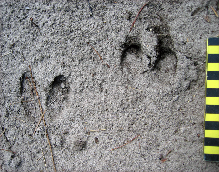
Feral hog tracks, showing nearly equal lengths and widths, rounded ends, and splaying of hooves, all three of which help to distinguish these from whitetail deer tracks. Scale in centimeters. (Photo by Anthony Martin, taken on Sapelo Island.)
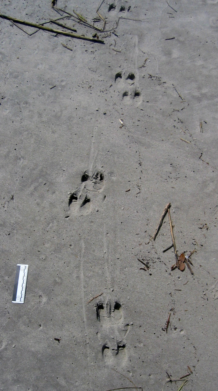
Feral hog trackway on upper part of a sandy beach (moving parallel to shore), showing slow diagonal walking pattern, verified by hoof dragmarks between sets of tracks. Scale = 10 cm (4 in). (Photo by Anthony Martin, taken on St. Catherines Island.)

Rooting pits are broad but shallow depressions – as much as 5 m (16 ft) wide and 30 cm (1 ft) deep – that are the direct result of feral hogs digging for food. In most instances, I suspect they are going for fungi and plant roots, but they probably also eat insect larvae, lizards, small mammals, and any other animals that live in burrows. These pits are typically in maritime forests and back-dune meadows, but I have seen them in salt marshes and dunes, and, most surprisingly, in the intertidal areas of beaches. What are they seeking and eating in beach sands? I think anything dead and buried that might be giving off an odor. I have even seen their tracks associated with broken carapaces of horseshoe crabs (Limulus polyphemus), a menu item that never would have occurred to me if I had not seen these traces.
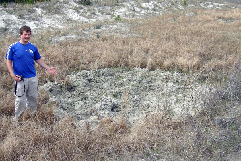
Rooting pit in back-dune meadow on St. Catherines Island. Former student, who answers to the parent-given appellation of “Andrew,” for scale. (Photograph by Anthony Martin.)
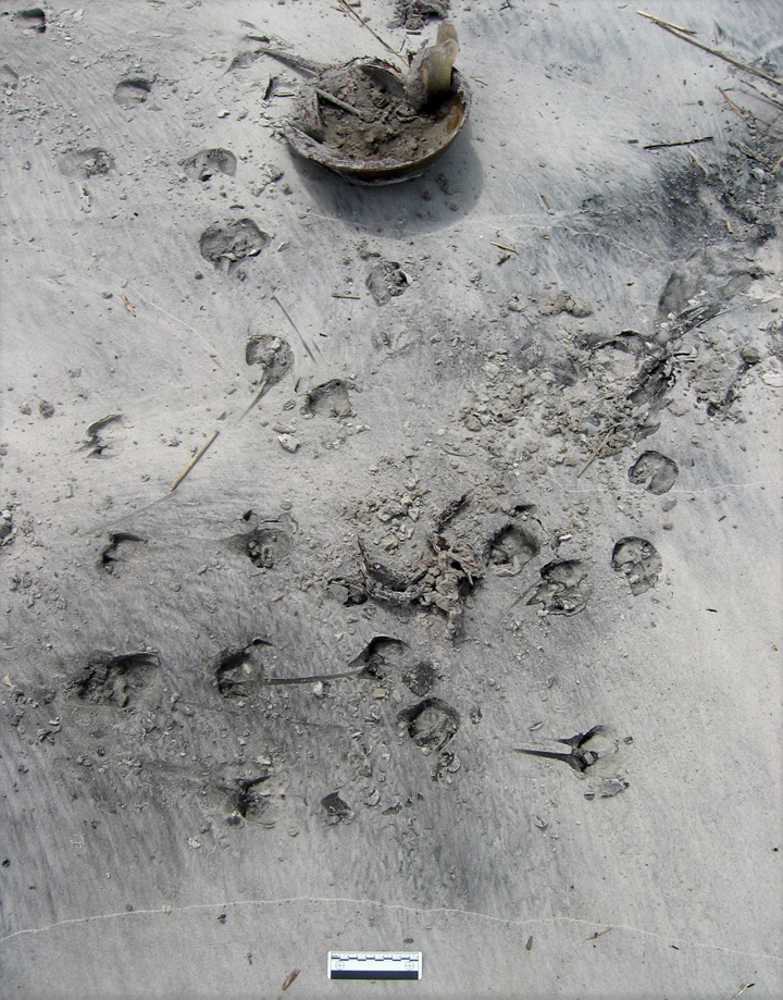
Evidence of feral hog feeding on a horseshoe crab (Limulus polyphemus). All I can say is, it must have been really hungry. (Photo by Anthony Martin, taken on St. Catherines Island.)

Wallows are similar in size and appearance to rooting pits, but have a different purpose, which is to provide hogs with relief from both the Georgia summer heat and biting insects that invariably go with this heat. These structures are often near freshwater wetlands in island interiors, but I’ve seen them next to salt marshes, too. If these wallows intersect the local water table, they also make for attractive little ponds for mosquitoes to breed, meaning these hog traces indirectly contribute to the potential spread of mosquito-borne diseases.
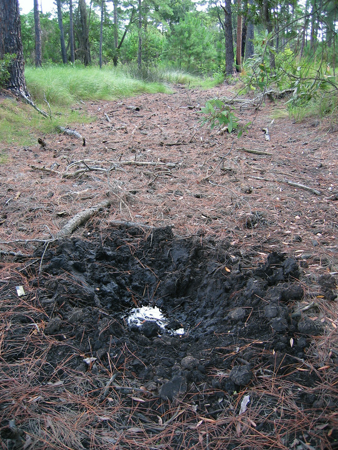
Wallow in maritime forest, Sapelo Island, with a standing pool of water indicating the local water table at the time. (Photo by Anthony Martin.)

Hog feces may look initially like deer pellets, but tend to aggregate in clusters. Most of the ones I have seen are filled with vegetation, but the extremely varied diets of feral hogs means you should expect nearly anything to show up in their scat.
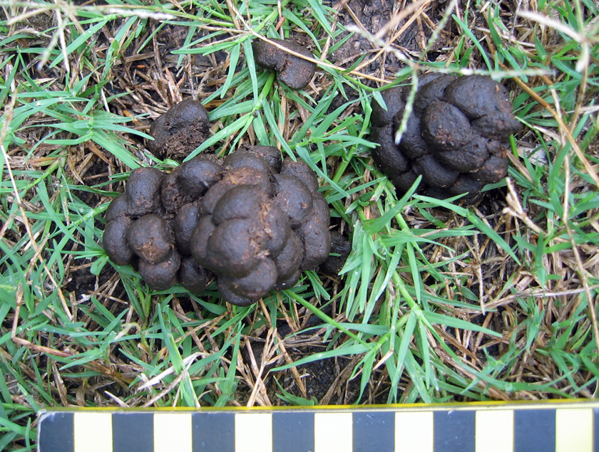
Feral hog feces on Sapelo Island, which is more clumped than that of whitetail deer. Scale in centimeters. (Photo by Anthony Martin, taken on Sapelo Island.)

Which of these traces would make it into the fossil record? I would certainly bet on at least some of their tracks getting preserved, based on the sheer ubiquity of these traces in nearly every sedimentary environment of a Georgia barrier island. Other likely traces would be their pits and wallows, although their broad size and shallow depths would make them difficult to recognize unless directly associated with tracks. Feces would be the least likely to make it into the fossil record as coprolites, unless these contained a fair amount of bone or other mineralized stuff, which could happen with hogs.

What to do about these hogs, and how to decrease the impacts of their traces? Well, as most people know, pigs are wonderful, magical animals that were domesticated specifically for their versatile animal protein. So one solution is more active and year-round hunting of hogs, and using them to supplement breakfasts, lunches, and dinners of local residents on the Georgia coast, a neat blend of reducing a harmful feral species while encouraging a chic “locavore” label on such food.

However, the sheer numbers of hogs on some of the islands would likely require a more systematic slaughter to make a dent in their numbers, an approach that would probably deter any ecotourism unrelated to hog hunting. (Let’s just say that firearms and bird watching are an uneasy mix.) The introduction of native predators is another possible solution. For example, Cumberland Island has a population of bobcats (Lynx rufus) that was introduced primarily to control the whitetail deer population, but these cats probably also take a toll on the feral hogs (although how much is unknown). I have even heard suggestions of reintroducing red wolves (Canis rufus) to a few of the islands. These pack-hunting predators were native to the southeastern U.S. before their extirpation by fearful European settlers, and probably would reduce feral hog populations, but just how much of an impact they would have is hard to predict.

In summary, the feral horses, cattle, and hogs of the Georgia barrier islands have significant effects on the ecology and geology of the Georgia barrier islands, and will continue to do so until creative solutions are proposed and implemented to reduce and otherwise manage their numbers. In the meantime, though, these invasive species present opportunities for us to study their traces, learn more about their unseen behaviors, and compare these behaviors with their evolutionary histories. More science is always good, and in this respect, the Georgia barrier islands are the gifts that keep on giving.
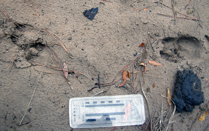
Traces of feral mammals on Sapleo Island: feral hog tracks strolling past a piece of feral cattle scat in a sandy road next to a maritime forest. What is the fate of these invasive species on the Georgia barrier islands, and how will these environments continue to change because of their presence? (Photo by Anthony Martin, taken on Sapelo Island.)

Further Reading

Ditchkoff, S.S., and West, B.C. 2007. Ecology and management of feral hogs. Human-Wildlife Conflicts, 1: 149-151.

Giuffra, E., Kijas, J.M.H., Amarger, V., Carlborg, Ö., Jeon, J.-T., and Andersson, L. 2000. The origin of the domestic pig: independent domestication and subsequent introgression. Genetics, 154: 1785-1791.

Mayor, J.J., Jr., and Brisbin, I.L. 2008. Wild Pigs in the United States: Their History, Comparative Morphology, and Current Status. University of Georgia Press, Athens, Georgia: 336 p.

Taylor, R.B., Hellgren, E.C., Gabor, T.M., and Ilse, L.M. 1998. Reproduction of feral pigs in southern Texas. Journal of Mammalogy, 79: 1325-1331.

Wood, G.W., and Roark, D.N. 1980. Food habits of feral hogs in coastal South Carolina. The Journal of Wildlife Management, 44: 506-511.
Why Study Traces in Georgia? A Celebration of the Familiar

For those of us who live in Georgia, we either forget or don’t know about the ecological and geological specialness of this part of the U.S. For example, my undergraduate students here in Atlanta often talk dreamily about their desire to visit the Amazon River basin, Costa Rica, Kenya, Australia, or other places far removed from Georgia, beguiled as they are by the exotic “other” qualities of those places with their biota and landscapes. On the other hand, almost none of these students have been to the Okefenokee Swamp, the Blue Ridge Mountains, the Cumberland Plateau, the long-leaf pine forests of Ichauway, or the Georgia barrier islands, unless my colleagues or I have taken them there on field trips. Yet these places, especially those with freshwater ecosystems, collectively hold a biodiversity nearly matching that of the Amazon River basin, an evolutionary consequence of the long geologic history of the Appalachian Mountains.

To be fair, I have likewise found myself succumbing to such place-based deflection and lack of appreciation for what is more-or-less in my backyard. In 2001, I realized that I had been to Brazil (three times) more often than Fernbank Forest (two times), even though Fernbank was only a five-minute bicycle ride from home in Decatur, Georgia. This imbalance was soon corrected, though, and many visits later, I learned to appreciate how this old-growth southern Appalachian forest in the middle of metropolitan Atlanta is a gem of biodiversity, every native species of plant and animal a facet testifying to their long evolutionary histories. Still, I wonder why we often ignore what is nearby, even if it is extraordinary?

Related to this quandary is one of the most common questions I encountered from friends, family, and colleagues while writing my book – Life Traces of the Georgia Coast – which was, “Why are you, a paleontologist and geologist, writing about the traces of modern plants and animals in Georgia?” This is a legitimate inquiry, but my answer surprises most people. I tell them that my main reason for staying here in Georgia to study the tracks, trails, burrows, nests, and other traces of its barrier islands is because these traces and their islands are world-class and world-famous. This high quality is directly linked to the biodiversity of the Georgia barrier islands, but also their unique geological histories compared to other barrier-island systems. Furthermore, these islands have inspired more than a few major scientific discoveries related to modern ecology and geology, some of which, made nearly 50 years ago, are still applicable to diagnosing the fossil record and the earth’s geologic history. In short, the Georgia barrier islands and their traces also reflect a legacy recognized by scientists far outside the confines of Georgia.

How so? I’ll explain in upcoming posts, and hope to demonstrate how the marvelous ecosystems of the Georgia coast and its geological processes are the proverbial gift that keeps on giving, continually helping us to better understanding the earth’s geologic past. Now that’s special!

Burrows at dawn: a partial view of the thousands of ghost-shrimp burrows dotting a Georgia beach at low tide, their entrances looking like tiny volcanoes. What makes these burrows so important, scientifically speaking, and why are they something that would cause scientists from outside of Georgia to travel and see in person? Photo by Anthony Martin and taken on Sapelo Island, Georgia.