
Legends and storytelling are an intrinsic part of being human. Given this statement, you might then also think of myths and other stories you’ve heard throughout your life. Which were the most memorable, and why? With such remembrances, your next step may be to do something else that is very much a part of being human, which is to wonder whether that myth or story holds some lesson applicable to real life. Whether a story is an accurate account of reality is beside the point, as its imparted teachings are sometimes more important than factual accuracy.
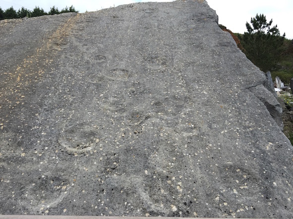 Modern scientists say these depressions in a tilted rock surface near Sesimbra, Portugal were made by sauropod dinosaurs in soft sediments during the Jurassic Period more than 150 million years ago. But what if you lived in this area during the 14th century? How would you explain these depressions? While you’re thinking about that, here’s another question: If I hadn’t told you these were dinosaur tracks, would you even know they were tracks? (Photograph by Anthony Martin.)
Yet, what if reality and scientific reasoning – with the latter thriving on a spirit of disproof – rudely intrudes on a good story, disrupting its original intent? In such instances, a legend previously regarded as literal truth may lose its narrative power, as we begin to doubt not just its details, but also its intent. Can anything useful be salvaged from a myth when skepticism assaults faith? Should we completely reject parables once we know foxes do not talk about grapes, sour or otherwise?
Less than two weeks ago I visited a place where the basic facts of a long-held legend had been disproved, yet a lesson from it remains. The place is Cabo Espichel, marked by a lighthouse, church, and small chapel on a plateau high above rocky cliffs along the southwest coast of Portugal. Cabo Espichel is about a 90-minute drive from the modern metropolis of Lisbon, yet it felt far more remote, and very much connected to a medieval past.
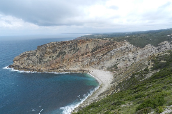 A view of Lagosteiros Bay from the top of Cabo Espichel. Also check out those gorgeous outcrops of tilted Jurassic and Cretaceous rocks! Gee, I wonder what trace fossils might be in them? (Photograph by Anthony Martin.)
The legend associated with that place concerns a 14th century visitation there by someone named Mary, who is also known by many other names: Saint Mary, Mary of Nazareth, Blessed Virgin Mary, Our Lady, The Madonna, or very simply the Mother of Jesus. Given the Catholic culture that is very much still a part of the Iberian Peninsula, her purported arrival to Portugal there was (and still is) considered a blessing and a ringing endorsement of Christianity there. Accordingly, the church complex is called the Santuário de Nossa Senhora do Cabo Espichel (“Sanctuary of Our Lady of Cape Espichel”).
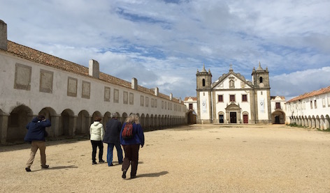 Ichnologists approaching the Santuário de Nossa Senhora do Cabo Espichel, Portugal, not on the way to confess their sins (that would have taken way too long), but to see the small chapel behind it, as well as some great coastal outcrops of Mesozoic rocks. So you might say they were there for a different type of worship. (Photograph by Anthony Martin.)
How did Mary get to Portugal from the Middle East? Given the absence of airlines then, she and the Baby Jesus traveled by boat. Once the Mother and Child reached the shore of Lagosteiros Bay below Capo Espichel, a giant mule carried them up the steep rock faces of Cabo Espichel. This scene came in a vision to two men in the area, who shared the same dream of her arrival on the same night. In a splendid example of confirmation bias, their testimony was taken quite seriously by the local populace and beyond, and has endured since.
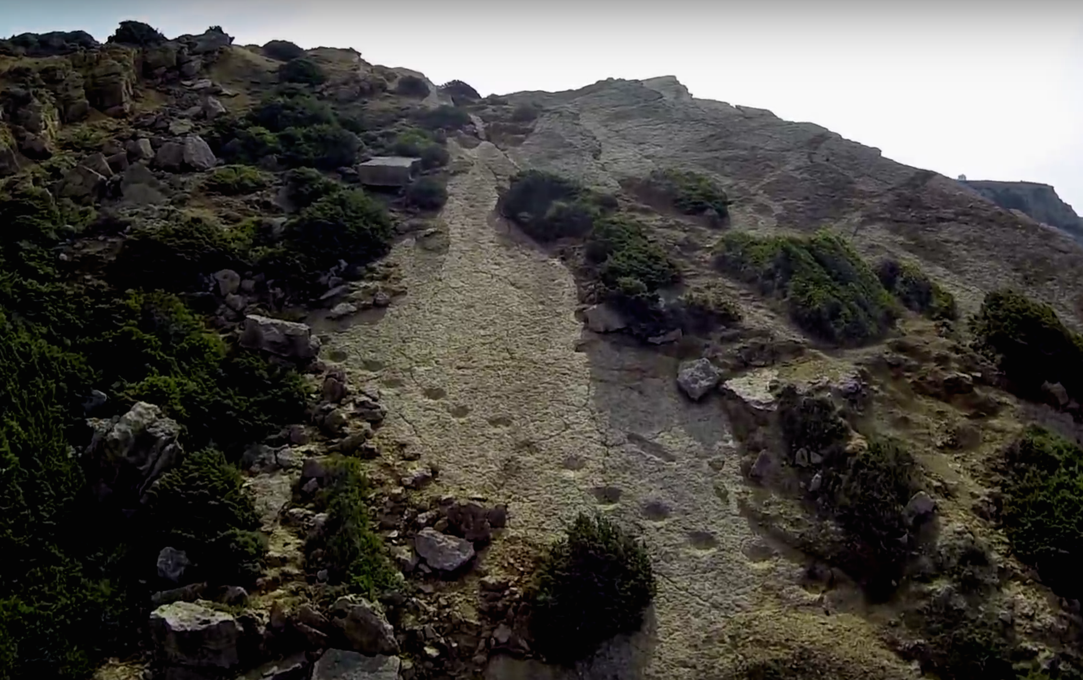
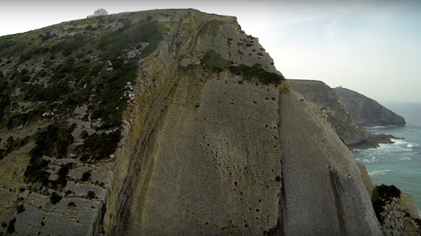 Cliff face below the present-day chapel and church at Cabo Espichel, with well-exposed and tilted bedding planes of sedimentary rock. This would have been the most likely route for a mule (giant or otherwise) to have accessed the top from Lagosteiros Bay. Photo is a still taken from an online edited drone video titled “Cabo Espichel – Dinosaur Trackway Adventure.” Related to the question asked in the previous caption: Huh, I wonder what those depressions on the rock face might be, how they relate to the legend, and the title of that video?
In commemoration of this momentous event, the church and chapel – the latter called Ermida da Memória (Chapel of Memory) – were built near the precipice. Portuguese royalty hosted annual feasts there, and many pilgrims put it on their spiritual “bucket list” as a must-visit place. Today, it is still visited by devout Catholics, who may be imagining themselves walking on the same holy ground trodden by Mary and her miraculous mule.
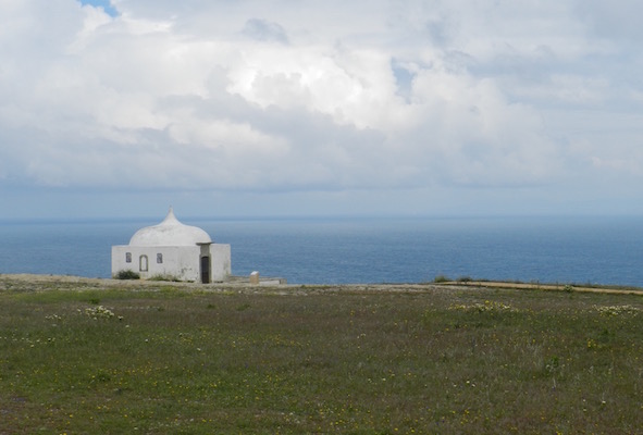 The Ermida do Memória seen from afar on Capo Espichel. Imagine it in the darkness of night, when suddenly a glow comes from the bay below. Inside this light, the head of a giant mule appears, and as more of its body emerges from the cliff edge, you see Mother Mary astride it carrying the Baby Jesus, accompanied by an aerial escort of angels and the most beautiful music you’re ever heard in your life. OK, Guillermo de Toro, I just wrote the scene for your next movie: the rest is up to you. (Photograph by Anthony Martin.)
So where did this legend come from: crazed fishermen who had spent one day too many at sea, villagers imbibing enthusiastically on local vinho verde, or clergymen overcome by ecclesiastic visions? No, this story actually had evidence backing it up. All one had to do is get in a boat just offshore, and you could see for yourself enormous footprints in the rocks leading from the sea to the top of the cliff at Cabo Espichel.
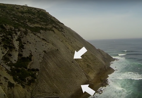 They’re a little tough to see from this far out, but the big white arrows help. The “mule tracks” are on tilted strata just above the bay, and compose diagonal-walking patterns. (Photo taken as still from video Cabo Espichel – Dinosaur Track Adventure. I would have prefaced that information with “Spoiler Alert,” but you did read the title of this post, right?)
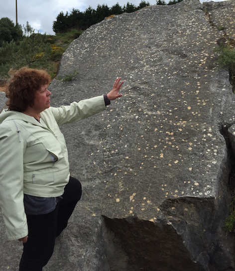
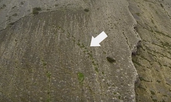 A closer view of a rock surface with the diagonal-walking pattern clearly defined, accentuated by vegetation growing in the depressions. Don’t believe me that these are from the same site? Look up “Cabo Espichel, Portugal” on Google Earth™, scan the rock surfaces just north of the chapel, and see them for yourself. (Photo again is still taken from video Cabo Espichel – Dinosaur Trackway Adventure.)
These tracks, people said, marked where the weight of the mule pressed into the rocks. Even better, some of these tracks formed patterns clearly made by four-legged animals, and individual tracks were crescent-shaped, resembling the feet of mules or other horse-like animals. As a result, one name applied to this place is Pedras de Mula, which translates as “Rocks of the Mule,” although Pegadas de Mula (“Tracks of the Mule”) is also applied.
Every good story also needs images, and this one has a particularly noteworthy visual aid. The building of a chapel on the site in the 16th century contains tile artwork commemorating this divine calling; however, the tile was probably made later, in the 18th century. Although the chapel interior is closed to the public, a open slot in its door afforded a glimpse of this depiction, aided by the zoom lens on my camera. Like any good illustration, the story is neatly encapsulated in the tiles: Mother Mary and The Baby Jesus riding on a mule, with angels in tow and stunned onlookers properly prostrating.
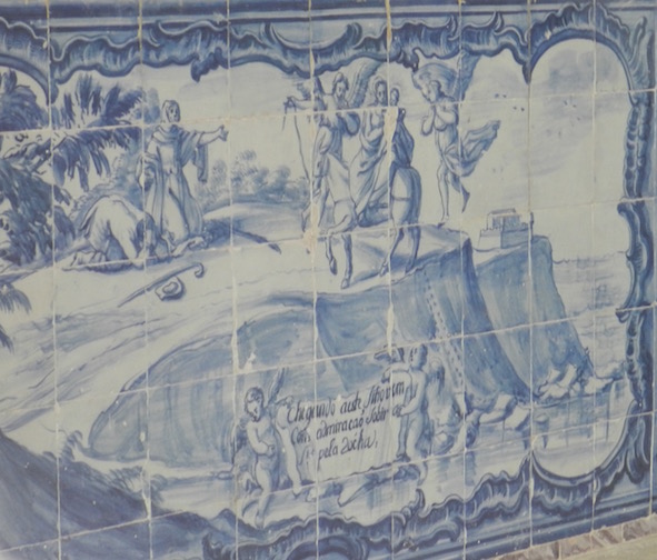 18th century tiled artwork inside the Ermida do Memória depicting the legend of Mary’s visitation of Cabo Espichel. To all artists out there (and I’m one of you), the original creator of this work is unknown, hence image credit cannot be assigned here. (Photograph by Anthony Martin.)
Centuries later, ichnology happened. Beginning in the mid-1970s, geologists and paleontologists realized that the Mesozoic rocks of Portugal, including those at and near Cabo Espichel, held dinosaur tracks. This consciousness has been affirmed many times since, with discoveries of tracks belonging to a wide variety of Jurassic and Cretaceous dinosaurs: theropods, ornithopods, stegosaurs, and sauropods among them. Portugal is now rightly renown as one of the best places in the world to see thousands of well-preserved dinosaur tracks, all within just a few hours drive of one another.
 A close-up of a dinosaur trackway – probably from a sauropod – on one of the rock surfaces at Cabo Espichel. As folks would say in my part of the U.S., “Those ain’t from no mule.” (Photo is still from video Cabo Espichel – Dinosaur Trackway Adventure.)
 Dr. Vanda Faria dos Santos, Portugal’s premier dinosaur tracker, telling us about the sauropod tracks at the Avelino tracksite, just south of Cabo Espichel. Notice the abundant depressions on a tilted rock face, very similar to those at Cabo Espichel. (Photograph by Anthony Martin.)
Of these tracks, those of sauropods were the most relevant to the tale of Cabo Espichel. The majority of sauropod tracks in Portugal are very large, especially those of the rear-foot (pes), which can be about a meter long and nearly as wide. The front-foot (manus) impressions are smaller, but still approach a half-meter wide, and are crescent-shaped. You know, like those of a horse, or mule.
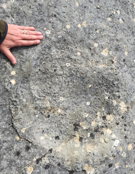 Front-foot (manus) track made by a Late Jurassic sauropod preserved as a cresent-shaped depression at the Avelino tracksite near Sesimbra, Portugal. (Photograph by Anthony Martin.)
A detailed field study of the tracks at Cabo Epischel, done by Martin Lockley, Christian Meyer, and Vanda Santos in 1993 and published in 1994, confirmed that the “mule tracks” at Cabo Epsichel were indeed those of sauropods. The original surfaces were of soft sediment and horizontal; only later did a combination of cementation and plate tectonics harden and tilt these rocks, with coastal erosion finally rendering their current appearance. Moreover, ten sauropod trackways on one of the bedding-plane surfaces there recorded the herding movements of seven smaller sauropods (juveniles) and three larger ones (adults), all of them walking in more-or-less the same direction. These results thus made the site scientifically famous, as it was one of the first convincing examples of family herding behavior in sauropods demonstrated from their footprints.
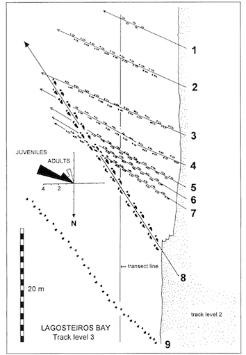 Trackway map of bedding plane at Cabo Espichel in article by Lockley, Meyer, and Santos (1994). The map shows parallel smaller (juvenile) sauropod trackways (numbers 1-7), followed by two larger (adult) sauropod trackways (numbers 8-9); another adult trackway is not on this figure, but was below the other two.
Here’s the full edited aerial-drone video linked previously, Cabo Espichel – Dinosaur Trackway Adventure. The video credit only says “rlage3,” so if the person/people who produced this would just let me know who you are, I’m more than glad to give full attribution. In the meantime, thanks much for providing such a nice overview of this beautiful and ichnologically rich area!
This situation with competing stories is where ichnology excels, as it is also a science based on storytelling. Granted, the story told by ichnologists is radically different from the one first accepted by the 14th century people of Portugal, or those since who have accepted the faith-based explanation for the tracks. On a personal note, I’m ex-Catholic; hell, I was an altar boy, went to a Catholic college for my undergraduate studies, and my mother was a more devout Catholic than most pontiffs. Thus I have much empathy for how people of faith (especially Catholics) feel about such things. So if pilgrims still chose to believe the tracks of Cabo Espichel were made by a giant mule bearing Mary and Jesus, and this fills them with joy, I’m cool with that. Just don’t tell me our science is wrong.
So now I will leave you with two provocative thoughts. The first is that the tile artwork in the chapel is the first known illustration of dinosaur tracks. Is it a scientifically accurate, to-scale, 3-D rotating digital model of a dinosaur trackway? No, but it’s still an illustration, and even though its interpretation does not qualify as science, it clearly shows a large, diagonal-walking trackway pattern on an inclined cliffside at Cabo Espichel. Let that sink in for a second: an 18th century artist must have seen dinosaur tracks on a bedding plane somewhere in that area, and faithfully reproduced them in a recognizable pattern.
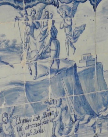 Close-up of tile artwork in the Ermida da Memória, connecting the trackway pattern to a mule, but which we now can be sure was inspired by the trackway of a Late Jurassic sauropod dinosaur. (Photograph by Anthony Martin.)
The second thought is that although the interpretations of this trackway might differ radically, what they share is true: These impressions in the rock were made by enormous, walking, four-legged animals. How many modern people today, their eyes no-doubt glued to their 21st-century devices, would stumble in such tracks, possibly never recognizing their connection to animal life? So rather than make fun of the people of Portuguese past, or whoever else must have observed the tracks preserved in the rocks of Cabo Espichel, we should celebrate those who recognized these depressions as traces of life. In this sense, then, the faith-filled people of the past were doing their own form of ichnology in Portugal, centuries before we modern ichnologists walked in the same place.
Afterword: Many other paleontologists and science historians have written about the discovery of the first known sauropod tracks in Portugal, so I will not repeat nor summarize their contributions here. Instead, I’ve included the following bibliography. Many thanks to Drs. Vanda Santos, Paulo Caetano, Carlos Neto de Carvahlo, and Joana Rodrigues for teaching other ichnologists and me about the long ichnological history of Cabo Espichel.
Further Reading
Atunes, M.T. 1976. Dinossáurios Eocretácios de Lagosteiros. Ciéncias da Terra (UNL), 1: 1-35.
Atunes, M.T. 1990. Dinossáurios em Sesimbra e Zambujal – Episódios de há cerca de 140 milhões de anos. Sesimbra Cultural: 12-14.
Chure, D. 2012. Sacred birds, lucky rhinos, and The Virgin and the sauropod. Land of the Dead (blog), January 7, 2012.
Lockley, M.G., Meyer, C.A., and Santos, V.F. 1994. Trackway evidence for a herd of juvenile sauropods from the Late Jurassic of Portugal. Gaia, 10: 29-40.
Lockley, M.G., Novikov, V., Santos, V.F., Nessov, L.A., and Forney, G. 1994. “Pegadas de mula”: an explanation for the occurrence of Mesozoic traces that resemble mule tracks. Ichnos, 3: 125-133.
Santos, V.F. 2008. Pegadas de dinossáurios de Portugal. Museo Nacional de História Natural da Universidade de Lisbõa, Lisbõa, 123.


