Erasing the Tracks of a Monster

Life can certainly imitate art, as can life traces. I was reminded of this last week while doing field work on St. Catherines Island (Georgia), and after encountering traces made by two very different animals, alligators and fiddler crabs. What was unexpected about these traces, though, was how they intersected one another in a way that, for me, evoked scenes from the recent blockbuster summer movie, Pacific Rim.

Alligator-Tracks-Fiddler-Crab-Burrows-1

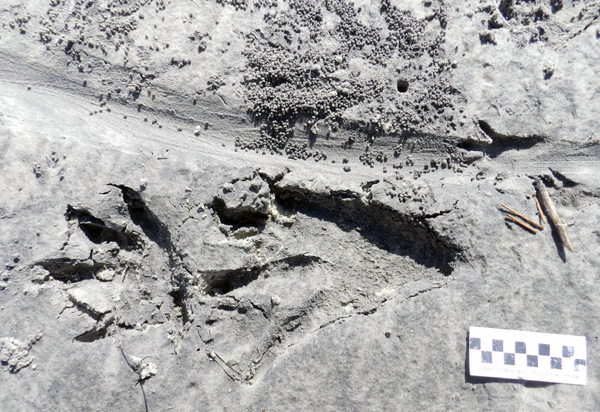
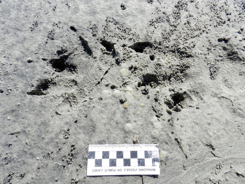
Could these be the tracks of a kaiju, making landfall on the shores of Georgia? Sorry to disappoint you, but they’re just the right-side and very large tracks of an American alligator (Alligator mississippiensis), accompanied by its tail drag-mark, left on a sandy area next to a salt marsh. Note the scale impressions in its rear-foot track, a symbol of the awesome reptilian awesomeness of its tracemaker. But wait: what nefarious nonsense is happening to the tail drag-mark, which is being covered by tiny balls of sand? Who made that hole next to the drag-mark? And what the heck was a raccoon (Procyon lotor) doing in the neighborhood, leaving its track on the tail drag-mark? With such a monster on the loose, shouldn’t that raccoon be hiding in the forest? (Photo by Anthony Martin, taken on St. Catherines Island; scale in centimeters.)

For anyone who has not seen Pacific Rim, you can read what I wrote about its distinctive fictional ichnology here. But what came to my mind while I was doing field work was one of the themes expressed early on in the film: how quickly humanity returned to normalcy following a lull in attacks by gigantic monsters (kaiju) that emerged from the ocean, destroyed major cities, and killed millions of people. It reminded me of how horrific hurricanes can strike a coast, such as the 1893 Sea Islands Hurricane that hit Georgia, but because no hurricane like it has happened there since, coastal developers think it’s hunky-dory to start building on salt marshes.

But enough about malevolent evil as exemplified by kaiju and coastal developers: let’s get back to traces. Last week, I was on St. Catherines Island for a few days with my wife (Ruth) and an undergraduate student (Meredith) to do some field reconnaissance of my student’s proposed study area. The area was covered by storm-washover fans; these are wide, flat, lobe-shaped sandy deposits made by storm waves, which span from the shoreline to more inland on barrier islands. We were trying to find out what traces had been left on these fans – tracks, burrows, scrapings, feces, and so on – which would tell us more about the distribution and behaviors of animals living in and around the washover fans.

Alligator-Trackway-St-Catherines-2
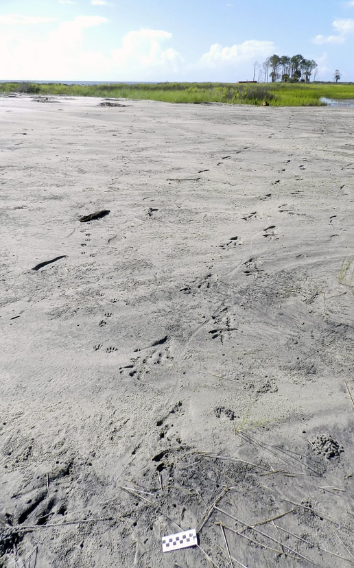
Part of a storm washover fan on St. Catherines Island (Georgia), with the sea to the left and salt marsh (with a patch of forest) in the background. Say, I wonder what made those tracks coming out of the tidal creek and toward the viewer? (Photograph by Anthony Martin.)

It didn’t take long for us to get surprised. Within our first half hour of walking on a washover fan and looking at its traces, we found a trackway left by a huge alligator, split in half by a wavy tail-drag mark. I recognized this alligator from its tracks, as I had seen them in almost exactly the same place more than a year before. Besides their size, though, what was remarkable about these tracks was their closeness to a salt marsh behind the washover fan. When we looked closer, we could see long-established trails cutting through the salt-marsh vegetation, which were the width of a large adult alligator.

Alligator-Trackway-St-Catherines-1
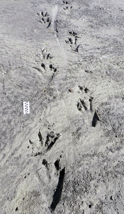
That ain’t no skink: the distinctive tracks and tail drag-mark of a large alligator, strolling through a storm-washover fan and next to a salt marsh. You think these animals are “freshwater only”? Traces disagree. Scale = 10 cm (4 in). (Photograph by Anthony Martin, taken on St. Catherines Island, Georgia.)

Alligator-Trail-Salt-Marsh-SCI
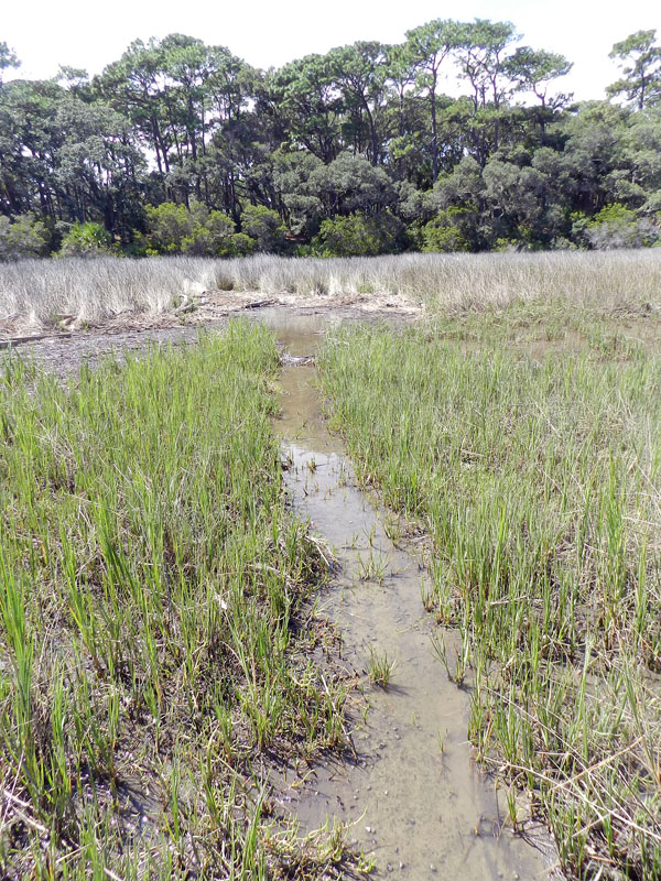
Alligator trail cutting through a salt marsh. Trail width was about 45-50 cm (18-20 in), which is about twice as wide as a raccoon trail. And it wasn’t made by deer or feral hogs either, because, you know, alligators. (Photograph by Anthony Martin, taken on St. Catherines Island, Georgia.)

So although the conventional wisdom about alligators is that these are “freshwater-only” animals, their traces keep contradicting this assumption. Sure enough, in the next few days, we saw more alligator tracks of varying sizes going into and out of tidal creeks, salt marshes, and beaches.

Based on a few traits of these big tracks, such as their crisp outlines (including scale impressions), the alligator had probably walked through this place just after the tide had dropped, only a couple of hours before we got there. But when we looked closer at some of the tracks along the trackway, we were astonished to see that something other than the tides had started to erase them, causing these big footprints to get fuzzy and almost unrecognizable.

The culprits were sand fiddler crabs (Uca pugilator), which are exceedingly abundant at the edge of the storm-washover fans closest to the salt marshes. These crabs are industrious burrowers, making J-shaped burrows with circular outlines corresponding to their body widths. They also scrape the sandy surfaces outside of their burrows to eat algae in the sand, then roll up that sand into little balls, which they deposit on the surface.

In this instance, after this massive alligator had stomped through their neighborhood, they immediately got back to work: digging burrows, scraping the surface, and making sand balls. Within just a few hours, parts of the alligator trackway was obscured. If these parts had been seen in isolation, not connected to the clear tracks and tail drag mark, I doubt we would have identified these slight depressions as large archosaur tracks.

Alligator-Tracks-Burrowed-Fiddler-CrabsHey, what’s going on here? Who would dare to erase and fill in giant alligator tracks? Don’t they know who they’re dealing with? (Photograph by Anthony Martin, taken on St. Catherines Island, Georgia.)

Alligator-Tracks-Destroyed-Fiddler-Crab-Burrows-1
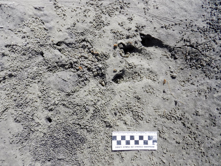
Going, going, gone: alligator tracks nearly obliterated by burrowing, surface scraping, and sand balls caused by feeding of sand fiddler crabs (Uca pugilator). (Photograph by Anthony Martin, taken on St. Catherines Island, Georgia; scale in centimeters.)

What was even neater, though, was how some of the fiddler crabs took advantage of homes newly created by this alligator. In at least a few tracks, we could see where fiddler crabs had taken over the holes caused by alligator claw marks. In other words, fiddler crabs saw these, said, “Hey, free hole!”, and moved in, not caring what made them.

Alligator-Tracks-Destroyed-Fiddler-Crab-Burrows
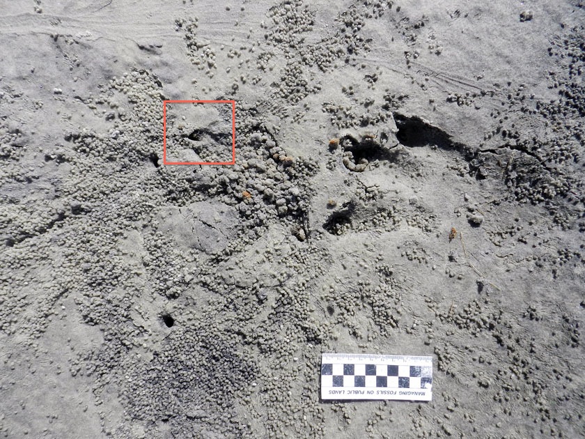
Don’t believe me about fiddler crabs moving into alligator claw marks? OK, then what’s that I see poking out of that alligator claw mark (red square)? (Photograph by Anthony Martin, taken on St. Catherines Island, Georgia; scale in centimeters.)

Fiddler-Crab-Burrow-Alligator-Claw-MarkWhy, it’s a small sand fiddler crab! Does it care that its new home is an alligator claw mark? Nope. Does ichnology rule? Yup. (Photograph by Anthony Martin, taken on St. Catherines Island, Georgia.)

Fiddler-Crab-Burrow-Alligator-Claw-2
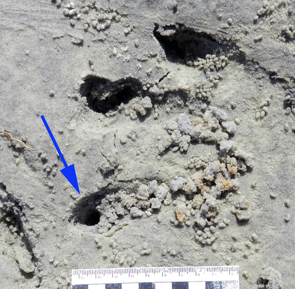
Need a free burrow? Then why start digging a new one when alligator claw marks (arrow) gives you a nice “starter burrow”? Notice the sculpted, round outline, showing the claw mark was modified by a crab. Also check out the sand balls left outside of the other claw marks, meaning these have probably been occupied and mined for food by fiddler crabs, too. (Photograph by Anthony Martin, taken on St. Catherines Island, Georgia; scale in centimeters.)

As a paleontologist, the main lesson learned from this modern example that can be applied to fossil tracks, is this: any tracks made in the same places as small, burrowing invertebrates – especially in intertidal areas – might have been destroyed or otherwise modified immediately by the burrowing and feeding activities of those much smaller animals. The secondary lesson is on how large vertebrate tracks can influence the behaviors of smaller invertebrates, resulting in their traces interacting and blending with one another.

More symbolically, though, these alligator tracks and their erasure by fiddler crabs also conjured thoughts of fictional and real analogues: Pacific Rim and coastal development, respectively. With regard to the latter, it felt too much like how, as soon as a hurricane (a meteorological “monster”) passes through a coastal area, we begin to talk about rebuilding in a way that, on the surface, wipes out all evidence that a hurricane ever happened.

Yet unlike fiddler crabs, we have memories, we have records – including the plotted “tracks” of hurricanes – and thanks to science, we can predict the arrival of future “monsters.” So the preceding little ichnological story also felt like a cautionary tale: pay attention to the tracks while they are still fresh, and be wary of those that vanish too quickly.

How Did Freshwater Crayfish Get on a Barrier Island?

Two weeks ago, during an all-too-brief visit to Jekyll Island (Georgia) over the Thanksgiving holiday weekend, I decided to check in on some old friends. When I was first introduced to them about four years ago (2008), their presence on Jekyll was a big surprise for me. But thanks to their distinctive traces and a little bit of detective work, I now know they’re on other Georgia barrier islands, too.

Why look, miniature volcanoes in the middle of a maritime forest on Jekyll Island! Or, could they be something else? (In science, that’s what we like to call an “alternative hypothesis.”) Photo scale (left) in centimeters. (Photograph by Anthony Martin.)

These “friends” were conical towers, which look like small lumpy volcanoes (stratovolcanoes, that is, not shield volcanoes), were the traces of freshwater crayfish. A few of the structures, composed of piled balls of sandy mud, also had circular holes in their centers, and they had all seemingly popped out of the forest floor along the edge of a pool of fresh water. All I needed to do to find them was look in the same place where I was first introduced to them, which was by a Jekyll Island resident who knew about their whereabouts.

The towers were 10-25 cm (4-6 in) wide at their bases, 7-10 cm (3-4 in) tall, and each of the rounded, oval balls of sediment was about 1-1.5 cm (0.4-0.6 in) wide. The overall appearance of the towers said “still fresh,” having not been appreciably weathered, and all that I saw in the area looked about the same age. Knowing a little bit about crayfish behavior, I figure they were made just after the last rainfall on Jekyll, maybe a week or so before I spotted them.

Close-up of a crayfish tower, with a circular hole in the center (that’s the burrow). Scale in centimeters. (Photograph by Anthony Martin, taken on Jekyll Island, Georgia.)

Crayfish that dig burrows adjust their depth according to the water table, which they must do to stay alive because they have gills. If the water table drops, they burrow deeper, but if the water table rises, they move their burrows up. For example, where I live here in the metro Atlanta area, crayfish towers often pop up in people’s backyards the day after a hard rain. (This also means that these people need to get flood insurance, because their backyards are on a floodplain. Thus also demonstrating yet another practical reason to know a little basic ichnology.)

Burrowing was (and still is) accomplished by crayfish using their prominent claws (chelipeds) as spades, rolling up the balls of sediment and placing them outside of the burrow entrance, and thus building up towers. But they also smooth out burrow interiors with their bodies through up-and-down and back-and-forth movement, resulting in their burrows having near-perfect circular cross sections. Crayfish burrow systems can be complicated, with vertical shafts connecting the surface with the below-ground parts, which can consist of branching horizontal tunnels and chambers; the last of these can even be occupied by multiple crayfish.

When I first saw these these towers and burrow cross-sections on Jekyll Island in 2008, I immediately knew they were from crayfish. My certainty was because such traces had been described in loving detail by crayfish researchers and ichnologists, linking these directly to their crustacean makers. In fact, just a few months ago, I saw an example of this connection between traces and tracemakers in my home of Decatur, Georgia, where the drying of a human-made pond there caused the crayfish to burrow into the former pond bottom and move about on its sediments in a desperate attempt to stay wet.

A high density of crayfish burrows in a recently drained human-made pond in Decatur, Georgia. Note the similarity of the towers, circular burrow cross-sections, and rounded balls of sediment to those of the Jekyll Island crayfish burrows. Scale with centimeters. (Photograph by Anthony Martin.)

“Are you looking at me?” Crayfish, about 5 cm (2 in) across, and probably a species of Procambarus, copping an attitude while guarding its burrow entrance. (Photograph by Anthony Martin, taken in Decatur, Georgia.)

With about 70 species documented in the state, Georgia is quite rich in crayfish diversity, qualifying it and bordering states in the southeastern U.S as a “biodiversity hotspot” for these animals. Freshwater crayfish are also geographically widespread – occurring in North and South America, Europe, Madagascar, Australia, New Zealand, New Guinea – a direct result of plate tectonics, which spread and isolated populations from one another during their evolutionary history.

In terms of that history, these crustaceans (decapods, more specifically) split from a common ancestor with marine lobsters about 240 million years ago, an age based on molecular clocks, which have been integrated with fossil evidence. I’ve also seen trace fossils that look very much like crayfish burrows in Late Triassic rocks, from about 210 million years ago, which suggests that burrowing began in this lineage early in the Mesozoic Era.

In a 2008 article I co-authored and published with six other scientists – three paleontologists and three zoologists – we described fossil burrows in rocks from the Early Cretaceous Period (about 115-105 million years ago) of Australia, and named what is still the oldest fossil crayfish in the Southern Hemisphere, Palaeoechinastacus australanus. In this article, we pointed out how burrowing was an adaptation that likely helped these crayfish survive polar winters in Australia during the Cretaceous, but also how burrowing abilities in general have given crayfish an upper claw, er, hand in making it past environmental crises in the geologic past.

Here’s the oldest known fossil freshwater crayfish in Australia and the rest of the Southern Hemisphere, Palaeoechinastacus australanus (= “ancient spiny crayfish of Australia”), found in 105-million-year-old rocks (Early Cretaceous) of southern Victoria. Not everything is there, but you can see most of its tail to the left and the right-side legs. Specimen is Museum Victoria, Melbourne, Australia. (Photograph by Anthony Martin.)

And here’s a bedding plane (horizontal) view of trace fossils attributed to freshwater crayfish burrows, preserved in 115-million-year-old rocks (also Early Cretaceous) near Inverloch, Victoria (Australia). The burrows were filled with sand originally, which cemented differently from the surrounding sediment, making them stand out in positive relief as they weather on the outcrop. Scale = 10 cm (4 in). (Photograph by Anthony Martin.)

So how did these crayfish get onto the Georgia barrier islands? Before answering that, I can tell you how they did not get there, which was from people. Because these are burrowing (infaunal) crayfish, and not ones that hang out on lake or stream bottoms (also known as epibenthic), it’s not very likely that humans purposefully introduced them on the islands for aquaculture. Let’s just say that digging up each crayfish burrow, which may or may not contain a crayfish, would require too much work to make crayfish etoufee worth the effort, no matter how good your recipe might be.

Mmmmm, flavorful freshwater decapod concoction [drooling sounds]. But first imagine having to dig up every single crayfish for this dish. Just to prevent this from happening, your recipe should have some qualifying statement, such as, “Make sure to use epibenthic crayfish, not infaunal ones!” (Original image, modified slightly by me, from Wikipedia Commons here.)

Another point to remember about crayfish is that they are freshwater-only animals, incapable of tolerating salt-water immersion, let alone swimming kilometers through marine-flavored waters to reach offshore islands. Yet I’ve seen their traces on Jekyll and two other Georgia barrier islands, and crayfish species have been reported from two additional islands. (For now I won’t say which other islands or identify the probable species of these crayfish until they’ve been properly studied. Sorry.)

What might seem strange to most people, though, is that I still haven’t seen a single living crayfish on any of the Georgia barrier islands. Nonetheless, seeing and documenting their traces is good enough for me to know where they’re living and how they’re behaving. This again demonstrates one of the many advantages of ichnology: you don’t actually have to see an animal to know it’s there, just as long as it leaves lots of identifiable traces.

Oh yeah: almost forgot about the title of this post. What’s my explanation for how the crayfish got to the islands, including Jekyll? I think they lived on the islands before they were islands. In other words, present-day crayfish on the islands descended from ones that originally lived on the mainland part of Georgia, but these were cut off from their original homeland by the last major sea-level rise (well before the current one, that is). This rise started as long as 11,000 years ago, when the last great ice age of the Pleistocene ended, shedding water from continental glaciers and expanding the seas.

So think of a salty moat filling in the low areas between what are now the Georgia barrier islands and the rest of Georgia, with crayfish on either side of it, metaphorically waving goodbye to one another with their claws. In this scenario, the crayfish of the Georgia barrier islands may represent relics left behind and isolated from their ancestral populations. They may have even undergone genetic drift and became new species, or are well on their way to reproductive isolation from their mainland relatives. But that’s just speculation on my part right now. Like I said, these critters need to be studied before anything can be said about them.

All of this neatly illustrates how our knowledge of the geological past ties in with the present, as well as how ichnology can be applied to conservation biology. With regard to the latter, these little muddy crayfish towers exemplify one of the dangers associated with any rapid, careless development of the Georgia barrier islands. What if most people aren’t aware of the unique plants and animals on the islands because at least some of this biodiversity lies below their feet? Without such knowledge, unheeded development may very well wipe out rare or previously unknown species that have been part of the ecological legacy of the Georgia coast for the past 10,000 years.

This is one of many reasons why environmental protection of the islands is still needed, even on semi-developed one like Jekyll. Fortunately, motivated people are working toward such protection on Jekyll, and most other Georgia barrier islands are under some sort of state or federal protection, or privately owned as preserves.

Nice maritime forest you got there. It’d be a shame if something happened to it. (Photograph by Anthony Martin, taken on Jekyll Island.)

What’s also happened on Jekyll Island is increased ecotourism, highlighted by the success of the Georgia Sea Turtle Center. The center, which opened in 2007, has a rehabilitation center for injured turtles, educates the public about sea turtles nesting on the Georgia coast, and helps to monitor turtle nests on Jekyll during the nesting season. And just how is this monitoring done? By looking for tracks of the nesting mothers on the beaches of Jekyll during nesting season, of course. (Say, didn’t I say something previously about using ichnology in conservation biology?)

So can a Jekyll Island Crayfish Center be far behind? Um, no. Still, it’s time to start thinking of species on the Georgia barrier islands and their traces as assets, bragging points that can be used to bolster ecotourism on the coast. Barrier-island biodiversity is an economic resource that will continue to pay off as long as the species survive and their habitats are protected, while simultaneously feeding our sense of wonder at how these species, including burrowing freshwater crayfish, got to the islands in the first place.

Further Reading

Breinholt, J., Ada, M. P.-L., and Crandall, K.A. 2009. The timing of the diversification of the freshwater crayfish. In Martin, J.W., Crandall, K.A., and Felder, D.L. (editors), Decapod Crustacean Phylogenetics, CRC Press, Boca Raton, Florida: 343-355.

Hobbs, H.H., Jr. 1981. The Crayfishes of Georgia. Smithsonian Institute Press, Washington, D.C.: 549 p.

Hobbs, H.H., Jr. 1988. Crayfish distribution, adaptive radiation and evolution. In: Holdich, D.M., Lowery, R.S. (editors), Freshwater Crayfish: Biology, Management and Exploitation. Croom Helm, London: 52-82.

Martin, A.J. 2011. Ichnology in a time of climate change: predicted effects of rising sea level and temperatures on organismal traces of the Georgia coast. Geological Society of America, Abstracts with Programs, 43(2): 86. Link here.

Martin, A.J., Rich, T.H., Poore, G.C.B., Schultz, M.B., Austin, C.M., Kool, L., and Vickers-Rich, P. 2008. Fossil evidence from Australia for oldest known freshwater crayfish in Gondwana. Gondwana Research, 14: 287-296.

P.S. So you’d like to hear more details on the crayfish of the Georgia barrier islands? Well, then you’re going to have to read my book, which starts out Chapter 5 (on terrestrial invertebrate traces) with a section titled The Crayfish of Jekyll Island. Yes, that’s a sales pitch, but you can also request your public library to get it, or borrow a copy from a friend. Which makes this more of a “knowledge pitch.”

Descent with Modification

At this time last year, Fernbank Museum of Natural History was hosting the Darwin exhibit. On loan from the American Museum of Natural History, this exhibit was a major coup for the museum and the Atlanta area, which has enjoyed a growing culture of celebrating science during the past few years. Along with this exhibit, the museum also planned and concurrently displayed an evolution-themed art show, appropriately titled Selections, which I wrote about then here.*

Descent with Modification (2011), mixed media (colored pencils and ink) on paper, 24″ X 36.” Although this artwork might at first look like a tentacled creature infested with crustaceans and living on a sea bottom, its main form actually mimics a typical burrow system made by ten-legged crustaceans (decapods). Yet it’s also an evolutionary hypothesis. Intrigued? If so, please read on. If not, there are plenty of funny cat-themed Web sites that otherwise require your attention. (Artwork and photograph of the artwork by Anthony Martin.)

One unusual feature of this art show was that five of the eight artists were also scientists (full confession: I was one of them). Furthemore, one of the other artists was married to a scientist (fuller confession: that would be my wife Ruth). The show stayed up for more than three months, which was also as long as the Darwin exhibit resided at Fernbank. Thus we like to think it successfully exposed thousands of museum visitors to the concept that scientists, like many other humans, have artistic inspirations and abilities, neatly refuting the stereotype that not all of us are joyless, left-brained automatons and misanthropes.

Last week I was reminded of this anniversary and further connections between science and art during a campus visit last week by marine biologist and crustacean expert Joel Martin (no relation). Dr. Martin was invited to Emory University to give a public lecture with the provocative title God or Darwin? A Marine Biologist’s Take on the Compatibility of Faith and Evolution. His lecture was the first of several on campus this year about the intersections between matters of faith and science, the Nature of Knowledge Seminar Series. This series was organized as a direct response to the university inviting a commencement speaker this past May who held decidedly strong and publicly expressed anti-science views.

Dr. Martin, who is also an ordained elder in his Presbyterian church and has taught Sunday school to teenagers in his church for more than 20 years, gave an informative, organized, congenial, and otherwise well-delivered presentation to an audience of more than 200 students, staff, faculty, and other people from the Atlanta community. In his talk, Martin effectively explored the false “either-or” choice often presented to Americans who are challenged by those who unknowingly misunderstand or deliberately misrepresent evolutionary theory in favor of their beliefs. Much of what he mentioned, he said, is summarized in a book he wrote for teenagers and their parents, titled The Prism and the Rainbow: A Christian Explains Why Evolution is Not a Threat.

I purposefully won’t mention any of the labels that have been applied to the people and organizations who promote this divisiveness between evolutionary theory and faith. After all, words have power, especially when backed up by Internet search engines. Moreover, it is an old and tired subject, of which I grow weary discussing when there is so much more to learn from the natural world. Better to just say that Martin persuasively conveyed his personal wonder for the insights provided by evolutionary theory, how science informs and melds with his faith, and otherwise showed how science and faith are completely compatible with one another. You know, kind of like science and art.

Previous to his arrival, his host in the Department of Biology asked Emory science faculty via e-mail if any of us would like to have a one-on-one meeting with Dr. Martin during his time here. I leaped at the chance, and was lucky enough to secure a half-hour slot in his schedule. When he and I met in my office, we had an enjoyable chat on a wide range of topics, but mostly on our shared enthusiasm for the evolution of burrowing crustaceans, and particularly marine crustaceans.

Ophiomorpha nodosa, a burrow network in a Pleistocene limestone of San Salvador, Bahamas. In this instance, the burrows were probably made by callianassid shrimp, otherwise known as “ghost shrimp,” and are preserved in what was a sandy patch next to a once-thriving reef from 125,000 years ago. (Photograph by Anthony Martin.)

Interestingly, during this conversation we also touched on on how art and science work together, and I was pleasantly surprised to find out that Dr. Martin is a talented artist, too. It turns out he has illustrated many of his articles with exquisite line drawings of his beloved subjects, marine crustaceans. Yes, I realize that some artists like to draw a line (get it?) between being an “artist” and an “illustrator,” with the latter being held in some sort of disdain for merely “copying” what is seen in nature. If you’re one of those, sorry, I don’t have the time or inclination to argue about this with you. (Now go back to putting a red dot on a white canvas and leave us alone.)

Cover art of branchiopod Lepidurus packardi from California, drawn by Joel W. Martin, for An Updated Classification of the Recent Crustacea, also co-authored by Joel W. Martin and George E. Davis: No. 39, Science Series, Natural History Museum of Los Angeles County, Los Angeles, California.

During our discussion in my office, I pointed out a enlarged reproduction of a drawing of mine depicting the burrow complex of an Atlantic mud crab (Panopeus herbstii). He immediately recognized it as a crustacean burrow, for which I was glad, because it is an illustration of just that in my upcoming book, Life Traces of the Georgia Coast.

Burrow complex made by Atlantic mud crab (Panopeus herbstii), originally credited to a snapping shrimp (Alpheus heterochaelis). Scale = 5 cm (2 in). (Illustration by Anthony Martin, based on epoxy resin cast figured by Basan and Frey (1977).

After his campus visit, though, I realized that an even more appropriate artistic work to have shown him was the following one made for the Selections art exhibit last fall, titled Descent with Modification. This title in honor of the phrase used by Charles Darwin to describe the evolutionary process, but also is a play on words connecting to the evolution of burrowing crustaceans.

Descent with Modification again, but this time look at it as an evolutionary chart, where the burrow junctions in the burrow system reflect divergence points (nodes) from common ancestors. For example, from left to right, the ghost shrimp is more closely related to a mud shrimp, and both of these are more closely related to the ghost crab (middle) than they are to the lobster and freshwater crayfish (right). The main vertical burrow shaft represents their common ancestry from a “first decapod,” which may have been as far back as the Ordovician Period, about 450 million years ago.

The image shows five burrowing crustaceans, or to be more specific, ten-legged crustaceans called decapods. Along with these is a structure, which has a burrow entrance surrounded by a conical mound of excavated and pelleted sediment, a vertical shaft connecting to the main burrow network, and branching tunnels that lead to terminal chambers. A burrowing crustacean occupies each chamber, and these are, from left to right: a ghost shrimp (Callichirus major), a mud shrimp (Upogebia pusilla), a ghost crab (Ocypode quadrata), a marine lobster (Homarus gammarus), and a freshwater crayfish (Procambarus clarkii).

Here’s the cool part (or at least I think so): this burrow system also serves as an evolutionary chart – kind of a cladogram – depicting the ancestral relationships of these modern burrowing decapods. For example, lobsters and crayfish are more closely related to one another (share a more recent common ancestor) than lobsters are related to crabs. Mud shrimp are more closely related to crabs than ghost shrimp. Accordingly, the burrow junctions show where these decapod lineages diverged. So the title of the artwork is a double entendre with reference to Darwin’s phrase describing evolution as a process of “descent with modification,” along with burrowing decapods undergoing change through time as they descend in the sediment.

Modern decapod burrows and trace fossils of probable decapod burrows support both the science and the artwork, too. Here are a few examples to whet your ichnological and aesthetic appetites:

Thalassinoides, a trace fossil of horizontally oriented and branching burrow systems made by decapods in Early Cretaceous rocks (about 115 mya) of Victoria, Australia. In this case, these burrows were likely by freshwater decapods, such as crayfish, which had probably diverged from a common ancestor with marine lobsters more than 100 million years before then. Scale = 10 cm (4 in). (Photograph by Anthony Martin.)

Thalassinoides again, but this time in limestones formed originally in marine environments, from the Miocene of Argentina. Note the convergence in forms of the burrows with those of the freshwater crayfish ones in Australia. Think that might be related to some sort of evolutionary heritage? Scale = 15 cm (6 in). (Photograph by Anthony Martin.)

Horizontally oriented burrow junction of a modern ghost shrimp – probably made by a Carolina ghost shrimp (Callichirus major) – exposed along the shoreline of Sapelo Island, Georgia. Note the pelleted exterior, which is also visible on the burrow networks of the fossil ones in the Bahamas, pictured earlier. So if fossilized, this would be classified as the trace fossil Ophiomorpha nodosa. Scale in centimeters. (Photograph by Anthony Martin.)

Two ghost-shrimp burrow entrances on a beach of Sapelo Island, Georgia, with the one on the right showing evidence of its occupant expelling water from its burrow. No scale, but burrow mound on right is about 5 cm (2 in) wide. (Photograph by Anthony Martin.)

Burrow entrance and conical, pelleted mound made by a freshwater crayfish (probably a species of Procambarus) in the interior of Jekyll Island, Georgia. Scale = 1 cm (0.4 in). (Photograph by Anthony Martin.)

So the take-away message of all of these musings and visual depictions is that evolution, faith, science, art, trace fossils, modern burrows, and burrowing decapods can all co-exist and be celebrated, regardless of whether we sing Kumbaya or not. So let’s stop dividing one another, get out there, and learn.

*I’m also proud to say that my post from October 17, 2011, Georgia Life Traces as Art and Science, was nominated for possible inclusion in Open Laboratory 2013. Thank you!

Further Reading

Basan, P.B., and Frey, R.W. 1977. Actual-palaeontology and neoichnology of salt marshes near Sapelo Island, Georgia. In Crimes, T.P., and Harper, J.C. (editors), Trace Fossils 2. Liverpool, Seel House Press: 41-70.

Martin, A.J. In press. Life Traces of the Georgia Coast: Revealing the Unseen Lives of Plants and Animals. Indiana University Press, Bloomington, IN: 680 p.

Martin, A.J., Rich, T.H., Poore, G.C.B., Schultz, M.B., Austin, C.M., Kool, L., and Vickers-Rich, P. 2008. Fossil evidence from Australia for oldest known freshwater crayfish in Gondwana. Gondwana Research, 14: 287-296.

Martin, J.W. 2010. The Prism and the Rainbow: A Christian Explains Why Evolution is Not a Threat. Johns Hopkins University Press, Baltimore, MD: 192 p.

Martin, J.W., and Davis. G.E. 2001. An Updated Classification of the Recent Crustacea, No. 39, Science Series, Natural History Museum of Los Angeles County, Los Angeles, California: 132 p.


Marine Moles and Mistakes in Science

A first day of field work in the natural sciences can be expected to hold surprises, no matter what type of science is being attempted. Sometimes these are unpleasant ones, such as finding out the fuel gauge in your field vehicle – which you are driving for the first time, and in a remote place – doesn’t work. Other times, you make a fantastic discovery, like a new species of spider, a previously undocumented invasive plant, or a fossil footprint. But sometimes you see something that just makes you scratch your head and say, “What the heck is that?”, or more profane variations on that sentiment.

What is this long, meandering ridge making its way through a beach to the high tide mark on Sapelo Island, Georgia, and what made it? If you’re curious, please read on. But if you already know what it is, then you know a lot more than I did the first time I saw something like this. (Photograph by Anthony Martin.)

The last of those three scenarios happened to me on Sapelo Island, Georgia, in June 2004. My wife Ruth was with me, and we had just arrived on the island the previous afternoon, having stayed overnight at the University of Georgia (Athens) Marine Institute, or UGAMI. We decided that our first full morning in the field would be at Nannygoat Beach on the south end of Sapelo, which is a 5-minute drive or a 20-minute walk from the UGAMI.

We drove a field vehicle there (the gas gauge and everything else worked), parked, and took the boardwalk over the coastal dunes. Our elevated view from the boardwalk afforded a good look at many insect, ghost crab, bird, and mammal tracks made in the early morning. Circular holes punctured the dunes, made by ghost crabs (Ocypode quadrata). Sand aprons composed of still-moist sand were next to these burrow entrances, bearing crisply defined ghost-crab tracks, although early-morning sea breezes had already started to blur these.

At some point after walking onto the beach, though, we saw traces that we had not noticed in previous visits to Sapelo, and ones I have rarely seen there or on other Georgia barrier islands since. These oddities were meters-long, slightly sinuous to meandering ridges, about 15-20 cm (6-8 in) wide, extending in the sandy areas from the dunes through the berm and down to the high-tide mark, where they ended abruptly.

Same meandering ridge shown in the first photo, but viewed from the high-tide mark, showing how it connects with the primary dunes. Note how a few holes are punched in the part near me: more about those soon. (Photograph by Anthony Martin, taken on Sapelo Island, Georgia. P.S.: My wife Ruth is the scale in both photos, fulfilling one of the top 10 signs that I might be a geologist.)

Although a few ridges crossed one another, they rarely branched, and if they did, the branches were quite short, only about 10-15 cm (4-6 in). When we followed them to the dunes, they seemed to originate from some unseen place below the sandy surfaces. We investigated further by cutting through some of the ridges to see what they looked like inside. They turned out to be mostly open tunnels with circular cross sections about 5 cm (2 in) wide, slightly wider than a U.S. dollar coin. They were mostly hollow, and only occasionally did we encounter a plug of sand interrupting tunnel interiors. This supposition was backed up by ridges that had collapsed into underlying voids. A few of the ridges stopped with a rounded end the same diameter as the ridge, or as a larger, raised, elliptically shaped “hill.”

Ridge with quite a bit of meander in it. Check out the short branch toward the top right, where the tracemaker must have changed its mind and backed up, then continued digging toward the viewer. Scale = 15 cm (6 in). (Photograph by Anthony Martin, taken on Sapelo Island, Georgia.)

Two separate ridges intersecting, caused by one crossing the other, resulting in “false branching.” Also notice the partial collapse of sand into underlying hollow tunnels and how one of the ridges ends in a rounded mound. Scale = 15 cm (6 in). (Photograph by Anthony Martin, taken on Sapelo Island, Georgia.)

A short ridge ending in a raised, elliptical “hill,” connected to a partially collapsed tunnel that is not otherwise evident as an elevated surface. Same scale as before. (Photograph by Anthony Martin, taken on Sapelo Island, Georgia.)

Ruth and I agreed that these tunnels were burrows, instead of some random features made by the winds, tides, or waves. But by what? Clearly their makers were impressive burrowers, capable of digging through meters of sand. Their bodies also were probably just a little narrower than the burrow interiors, which helped us to think about body sizes. Then we considered where we were – dunes and beach – and what animals were the most likely ones to burrow in these environments.

A process of elimination – determining what they were not – was a good way to start figuring out their potential makers. For example, no way these burrows were from insects, such as beetle larvae, ant lion larvae, or mole crickets, because they were just too big. Insects also have a tough time handling salinity, so once they got to the surf zone with its saturated, saline sand, they would have had problems, or (more likely) an aversive reaction and turned around immediately instead of plowing ahead.

Insect burrow in coastal dune sand, made by a small beetle. Look at both the form and scale, and you’ll see this is not a match for what we were seeing. Scale in centimeters. (Photograph by Anthony Martin, taken on Cumberland Island, Georgia.)

Small mammals, like beach mice (Peromyscus polionotus), didn’t seem like good candidates either. Beach-mouse burrows are totally different from what we were seeing, and their burrows do not run all of the way down to the intertidal zone. Mice, like insects, also don’t like marine-flavored water; even if they might be able to temporarily tolerate it, they wouldn’t continue to burrow through moist, salty sand.

A beach-mouse burrow, with their tracks coming and going. Either the mice dug this burrow, or they occupied an abandoned ghost-crab burrow. Regardless, this also doesn’t match our mystery traces. Scale in millimeters. (Photograph by Anthony Martin, taken on Little St. Simons Island, Georgia.)

This led to an initial hypothesis that these burrows were from one of the most common larger burrowing animals in the area, and one comfortable in dune, berm, and beach environments with saturated, salty sand. These could only be from ghost crabs, I thought, an explanation supported by undoubted ghost crab burrows that perfectly intersected these tunnels, accompanied by undoubted ghost-crab tracks.

Ghost-crab burrows intersecting tunnels, accompanied by lots of ghost-crab tracks. Wow, that’s really convincing circumstantial evidence, wouldn’t you say? (Photograph by Anthony Martin, taken on Sapelo Island, Georgia.)

End of story, right? Well, no. I and a lot of other scientists have said this before, but it bears repeating: part of how science works is that in its practice we do not prove, we disprove. I somehow knew the “ghost crab burrowing horizontally through meters of sand from the dunes to the beach” hypothesis was a shaky one, and it bothered me that it just didn’t seem right. So I started reading as much as possible about ghost-crab burrowing behaviors. I thought I already knew a lot about this subject, but nonetheless was willing to acknowledge that there might be some holes in my learning (get it – holes?) that needed filling (get it – filling? Oh, never mind).

The gentle reader probably surmised what happened next. That’s right: not a single peer-reviewed reference mentioned ghost crabs digging meters-long shallow tunnels from the dunes to the beach. So either I was wrong, or I had documented a previously unknown and spectacular tracemaking behavior in this very well-studied species. A single cut by Occam’s Razor simply said, “You’re wrong.”

You thought I made long horizontal burrows that go all of the way from the dunes to the surf zone? Wow, you primates are dumber than I thought. (Photograph by Anthony Martin, taken on Sapelo Island, Georgia.)

If not a ghost crab then, what else could make meters-long horizontal burrows of the diameter we had seen? This is when I began to reconsider my original rejection of moles as possible tracemakers.

So what am I: chopped liver? (Photograph from Kenneth Catania, Vanderbilt University, and taken from Wikipedia.org here.)

Here’s what was the most interesting about this mistaken interpretation: it was made because of where we were. In other words, our initial mystification about these traces stemmed from their environmental context. Had we seen these burrows winding down a sandy road in the middle of a maritime forest on Sapelo Island, we would not have hesitated to say the word “mole.” Yet because we saw exactly the same types of burrows in coastal dunes and beaches, we said, “something else.”

A long, meandering mole burrow in the sandy road going through a maritime forest on the north end of Sapelo Island. So if you see a burrow like this in the forest, you instantly say “mole.” But if you see it on the beach, you say, “Um, uh, duh…must be something else!” My tracks (size 8 1/2, mens) and 15 cm (6 in) photo scale for, well, scale. (Photograph by Anthony Martin.)

Another long, meandering ridge ended in a rounded “hill,” a trace that no one would hesitate to call a mole burrow, especially because it’s in the middle of a maritime forest. (Photo by Anthony Martin, taken on Sapelo Island, Georgia.)

A trip back to the literature further confirmed the mole hypothesis while also serving up a big slice of humble pie. I was embarrassed to find that these same burrows were described and interpreted as mole burrows in an article published in 1986. Even more mortifying: my dissertation advisor (Robert “Bob” Frey) was the first author on the article; it had been published while I was doing my dissertation work with him; and I had read the article years ago, but didn’t remember the part about mole traces. It was like these burrows were saying to me, “Go back to school, young man.”

OK, so these are mole burrows. Case closed. Now that we’ve identified them, we can stop thinking about them, and go on to name something else. But that ain’t science either, is it? This one answer – mole burrows – actually inspires a lot of other questions about them, which could lead to heaps more science:

Which moles made these burrows? The Georgia barrier islands have two documented species of moles, the eastern mole (Scalopus aquaticus) and star-nosed mole (Condylura cristata). Of these two, eastern moles are relatively common on island interiors, whereas star-nosed moles are either rare or locally extinct from some of the islands. But star-nosed moles are also more comfortable next to water bodies and seek underwater prey. So could these traces actually signal the presence of star-nosed moles in dune and beach environments? Frey and his co-author, George Pemberton, originally interpreted these as eastern mole burrows, but they also didn’t eliminate the possibility of star-nosed moles as the tracemakers, either.

What is the evolutionary history of moles on the Georgia barrier islands? Are these moles descended from populations isolated from mainland ones 10,000 years ago by the post-Pleistocene sea-level rise, or do they represent more modern stock that somehow made its way to the islands? A genetic study would probably resolve this issue, but who the heck is going to compare the genetic relatedness of moles from the Georgia barrier islands to those on the mainland?

What were they eating? Moles don’t just burrow for the exercise, but for the food. While burrowing, they are also voraciously chowing down on any invertebrate they encounter in the subsurface. But what would they eat in beach sands? As many shorebirds know, Georgia beaches are full of yummy amphipods, which would likely more than substitute for a mole’s typical earthworm and insect-filled diet in terrestrial environments. Yet as far as I can find in the scientific literature, no one has documented mole stomach contents or scat from coastal environments to test whether these small crustaceans are their main prey or not.

What happened to these moles once their burrows got to the surf zone? Did they turn around and burrow back, or did they go for a swim in the open ocean? The latter is actually not so far fetched, as moles are excellent swimmers, especially star-nosed moles. But how often would they do this?

Just how common (or rare) are these burrows in beaches? Just because I just perceive these burrows as rare could be an example of sample bias. Yes, I wrote an entire book about Georgia-coast traces and tracemakers and have done field work on the islands since 1998. But I don’t live on the Georgia barrier islands, nor have I spent more than a week continuously on any of them. Keenly observant naturalists who live on the islands or otherwise spend much time there could better answer this question than me. I suspect they’re actually much more common than I originally supposed, and now look for them to photograph or otherwise document whenever I go back to any of the islands.

Would such burrows preserve in the geologic record? Probably so, especially if they were made in dunes and filled with a differently colored or textured sand. But I’ll bet that nearly every paleontologist or geologist would make the same mistake I did, and reach for a burrowing marginal-marine crab or some other invertebrate as the tracemaker.

Geologists would be further fooled if fossil mole tunnels were intersected by genuine ghost-crab burrows, which would constitute a great example of a composite trace made by more than one species of animal. But why did the crabs burrow into the mole tunnels? Because it was easier. After all, the moles left hollow spaces and loosened sand over wide areas, practically begging ghost crabs to exploit these disturbed areas.

Anyway, I doubt many geologists would think of a small terrestrial mammal as a tracemaker for such burrows in sedimentary rocks formed in marginal-marine environments, although I’d love to be proved wrong on this. I’m hoping my writing about it here will help to prevent such confusion, and that whoever benefits from it will buy me an adult beverage as thanks.

In summary, this example of making a crab burrow out of a mole tunnel thus serves as a cautionary tale of how where we are when making observations in the field can influence our perceptions. But it also goes to show us how our wonderment with what we observe in natural environments can be renewed and encouraged by daring to be wrong once in a while, and learning from those mistakes.

Further Reading

Frey, R.W., and Pemberton, S.G. 1986. Vertebrate lebensspuren in intertidal and supratidal environments, Holocene barrier island, Georgia. Senckenbergiana Maritima, 18: 97-121.

Gorman, M.L., and Stone, R.D. 1990. The Natural History of Moles. University of Chicago Press, Chicago, Illinois: 138 p.

Harvey, M.J. 1976. Home range, movement, and diel activity of the eastern mole, Scalopus aquaticus. American Midland Naturalist, 95: 436-445.

Henderson, R.F. 1994. Moles. Prevention and Control of Wildlife Damage, Paper 49, University of Nebraska, Lincoln: D51-58. (Entire text here.)

Hickman, G.C. 1983. Influence of the semiaquatic habit in determining burrow structure of the star-nosed mole (Condylura cristata). Canadian Journal of Zoology, 61: 1688-1692.

The Lost Barrier Islands of Georgia

The Georgia coast is well known for its historic role in the development of modern ecology, starting in the 1950s and ongoing today. But what about geologists? Fortunately, they were not long behind the ecologists, starting their research projects on Sapelo Island and other Georgia barrier islands in the early 1960s. Indeed, through that seminal work and investigations afterwards, these islands are now renown for the insights they bestowed on our understanding of sedimentary geology.

Why would geologists be attracted to these islands made of shifting sand and mud that were nearly devoid of anything resembling a rock? Well, before sedimentary rocks can be made, sediments are needed, and those sediments must get deposited before solidifying into rock. So these geologists were interested in learning how the modern sands and muds of the barrier islands were deposited, eroded, or otherwise moved in coastal environments, a dynamism that can be watched and studied every day along any Georgia shoreline. The products of this sediment movement were sedimentary structures, which were either from physical processes – such as wind, waves, or tides – or biological processes, such as burrowing. Hence sedimentary structures can be classified as either physical or biogenic, respectively.

Cabretta Beach on Sapelo Island at low tide, its sandflat adorned with beautiful ripples and many traces of animal life. Sand is abundant here because of a nearby tidal channel and strong ebb-tide currents that tend to deposit more sand than in other places around the island. This sand, in turn, provides lots of places for animals that live on or in the sand, making trails and burrows, demonstrating how ecology and geology intersect through ichnology, the study of traces.  Speaking of traces, what are all of those dark “pipes” sticking out of that sandy surface? Hmmm… (Photograph by Anthony Martin.)

These geologists in the 1960s were among the first people in North America to apply what they observed in modern environments to ancient sedimentary deposits, and just like the ecologists, they did this right here in Georgia. For example, in 1964, a few of these geologists – John H. Hoyt, Robert J. Weimer, and V.J. (“Jim”) Henry – used a combination of: geology, which involved looking at physical sedimentary structures and the sediments themselves; modern traces made by coastal Georgia animals; and trace fossils. Through this integrated approach, they successfully showed that the long, linear sand ridges in southeastern Georgia were actually former dunes and beaches of ancient barrier islands.

These sand ridges, barely discernible rises on a mostly flat coastal plain, are southwest-northeast trending and more-or-less parallel to the present-day shoreline. Remarkably, these ridges denote the positions of sea-level highs during the last few million years on the Georgia coastal plain. The geologists applied colorful Native American and colonial names to each of these island systems – Wicomico, Penholoway, Talbot, Pamlico, Princess Anne, and Silver Bluff – with the most inland system reflecting the highest sea level. So how did these geologists figure out that a bunch of sand hills were actually lost barrier islands? And what does this all of this have to do with traces and trace fossils?

Map showing positions of sand ridges that represent ancient barrier islands, with each ridge marking the fomer position of the seashore. The one farthest west (Wicomico) represents the highest sea level reached in the past few million years, whereas the current barrier islands reflect an overlapping of two positions of sea level, one from about 40,000 years ago (Silver Bluff), and the other happening now. (Photograph by Anthony Martin, taken of a display at the Sapelo Island Visitor Center.)

Here’s how they did it. They first observed modern traces on Georgia shorelines that were burrows made by ghost shrimp, also known by biologists as callianassid shrimp. On a sandy beach surface, the tops of these burrows look like small shield volcanoes, and a burrow occupied by a ghost shrimp will complete that allusion by “erupting” water and fecal pellets through a narrow aperture.

Top of a typical callianassid shrimp burrow, looking much like a little volcano and adorned by fecal pellets, which coincidentally resemble “chocolate sprinkles,” but will likely disappoint if you do a taste test. (Photograph by Anthony Martin, taken on St. Catherines Island.)

A couple of ghost shrimp, which are either a male-female pair of Carolina ghost shrimp (Callichirus major) or a Carolina ghost shrimp and a Georgia ghost shrimp (Biffarius biformis). Sorry I can’t be more accurate, but I’m an ichnologist, not a biologist (although I could easily play either role on TV). Regardless, notice they have big claws, which they use as their main “digging tools.” The tracemakers look a little displeased about being outside of their protective burrow environments, but be assured I thanked them for their contribution to science, and promptly threw them back in the water so they could burrow again. Scale = 1 cm (0.4 in) (Photograph by Anthony Martin, taken on St. Catherines Island, Georgia.)

Just below the beach surface, these interior shafts widen considerably, making these burrows look more like wine bottles than volcanoes. This widening accommodates the ghost shrimp, which moves up and down the shaft to irrigate its burrow by pumping out its unwanted feces (understandable, that) and circulating oxygenated water into the burrow. Balls of muddy sand reinforce the burrow walls like bricks in a house, stuck together by shrimp spit, and the burrow interior is lined with a smooth wall of packed mud.

A small portion of a ghost-shrimp burrow, showing its wall reinforced by rounded pellets of sand and stuck together with that field-tested and all-natural adhesive, shrimp  spit. Photograph by Anthony Martin, taken on Sapelo Island.

Amazingly, these shafts descend vertically far below the beach, as much as 2-3 meters (6.5-10 feet) deep. Here they turn horizontal, oblique, and vertical, and tunnels intersect, branch, and otherwise look like a complex tangle of piping, perhaps reminding baby-boomers of “jungle gyms” that they used to enjoy as children in a pre-litigation world. Who knows what goes on down there in such adjoining ghost-shrimp burrow complexes, away from prying human eyes?

The deeper part of a modern ghost-shrimp burrow, exposed by erosion along a shoreline and revealing the more complex horizontally oriented and branching networks. Gee, do you think these burrows might have good fossilization potential? (Photograph by Anthony Martin, taken on Sapelo Island.)

See all of those burrow entrances on this sandy beach? Now imagine them all connecting in complex networks below your feet the next time you’re walking along a beach. Feels a little different knowing that, doesn’t it? (Photograph by Anthony Martin, taken on Sapelo Island.)

Interestingly, these burrows are definitely restricted to the shallow intertidal and subtidal environments of the Georgia coast, and their openings are visible at low tide on nearly every Georgia beach. Hence if you found similar burrows in the geologic record, you could reasonably infer where you were with respect to the ancient shoreline.

I think you now know where this is going, and how the geologists figured out what geologic processes were responsible for the sand ridges on the Georgia coastal plain. Before doing field work in those area, the geologists may have already suspected that these sandhills were associated with former shorelines. So with such a hypothesis in mind, they must have been thrilled to find fossil burrows preserved in the ancient sand deposits that matched modern ghost-shrimp burrows they had seen on the Georgia coast. They also found these fossil burrows in Pleistocene-age deposits on Sapelo Island, which helped them to know where the shoreline was located about 40,000 years ago with respect to the present-day one. This is when geologists started realizing that the Georgia barrier islands were made of both Pleistocene and modern sediments as amalgams of two shorelines, and hence unlike any other known barrier islands in the world.

Vertical shaft of a modern ghost-shrimp burrow eroding out of a shoreline on Cabretta Beach, Sapelo Island. Scale in centimeters. (Photograph by Anthony Martin.)

Vertical shaft of a fossil ghost-shrimp burrow eroding out of an outcrop in what is now maritime forest on Sapelo Island, but we know used to be a shoreline because of the presence of this trace fossil. Scale in centimeters. (Photograph by Anthony Martin.)

Geology and ecology combined further later in the 1960s, when paleontologists who also were well trained in biology began looking at how organisms, such as ghost shrimp, ghost crabs, marine worms, and many other animals changed coastal sediments through their behavior. So were these scientists considered geologists, biologists, or ecologists? They were actually greater than the sum of their parts: they were ichnologists. And what they found through their studies of modern traces on the Georgia barrier islands made them even more scientifically famous, and these places became recognized worldwide as among the best for comparing modern traces with trace fossils.

Further Reading:

Hoyt, J.H., and Hails, J.R. 1967. Pleistocene shoreline sediments in coastal Georgia: deposition and modification. Science, 155: 1541-1543.

Hoyt, J.H., Weimer, R.J., and Henry, V.J., Jr. 1964. Late Pleistocene and recent sedimentation on the central Georgia coast, U.S.A. In van Straaten, L.M.J.U. (editor), Deltaic and Shallow Marine Deposits, Developments in Sedimentology I. Elsevier, Amsterdam: 170-176.

Weimer, R.J., and Hoyt, J.H. 1964. Burrows of Callianassa major Say, geologic indicators of littoral and shallow neritic environments. Journal of Paleontology, 38: 761-767.