Tracking That Is Otterly Delightful

Writing about a place, its environments, and the plants and animals of those environments is challenging enough in itself. Yet to write about that place and what lives there, but without actually being there, seems almost like a type of fraud. Sure, given a specific place, I could read everything ever published about it, watch documentaries or other videos about it, carefully study 3-D computer-rendered images of its landscapes, interview people who have spent much time there, and otherwise gather information vicariously, all without experiencing it directly. But then is my writing just about the shadows on the wall of the cave?
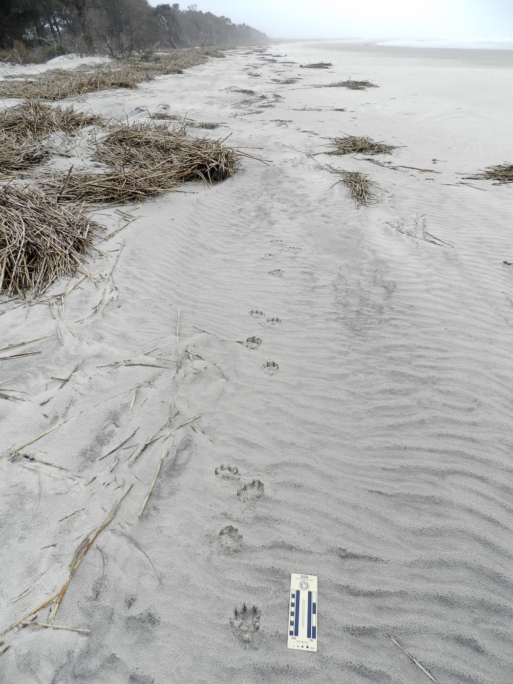
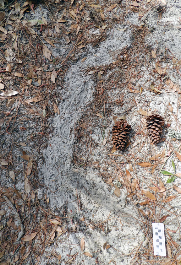
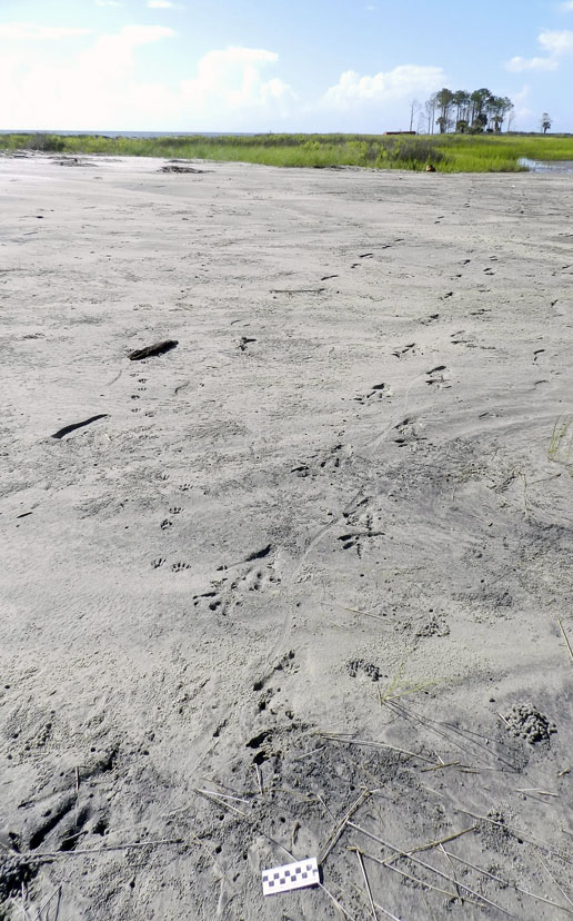
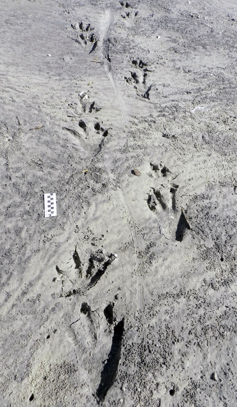
River-Otter-Tracks-Sapleo-Beach-1What do you see in this photo? I see fine quartz and heavy-mineral sand, originally parts of much larger rocks and forming parts of the Appalachian Mountains. I see the sand blowing down a long beach, but pausing to form ripples. I see a river otter galloping alongside the surf, slowing to a lope, then a trot, then back to a lope and a gallop. I see a brief rain shower, only about two hours after the otter has left the beach. (Photo by Anthony Martin, taken on Sapelo Island, Georgia.)

This pondering, of course, brings us to river otters. Yesterday, while on the third of a four-day writing retreat to Sapelo Island on the Georgia coast, my wife Ruth and I spent nearly an hour tracking a river otter along a long stretch of beach there. Had I read about river otters and their tracks before then? Yes. Had I watched video footage of river otters? Yes. Had I written about river otters and their tracks before then? Yes. Had I seen and identified their tracks before then? Yes. Had I seen river otters in the wild for myself? Yes, yes, and yes.

But still, this was different. When I first spotted the tracks on the south end of a long stretch of Cabretta Beach on Sapelo, I thought they would be ordinary. Granted, finding otter tracks is always a joy, especially when I’ve seen them on stream banks in the middle of Atlanta, Georgia. (Seriously, folks: river otters live in the middle of Atlanta. How cool is that?) And because Sapelo only has a few humans and is relatively undeveloped, your chances of coming across otter tracks on one of the beaches there isn’t like winning a lottery. But still.
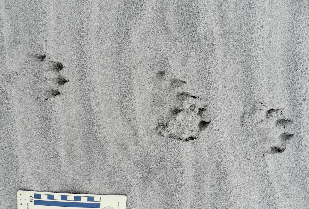
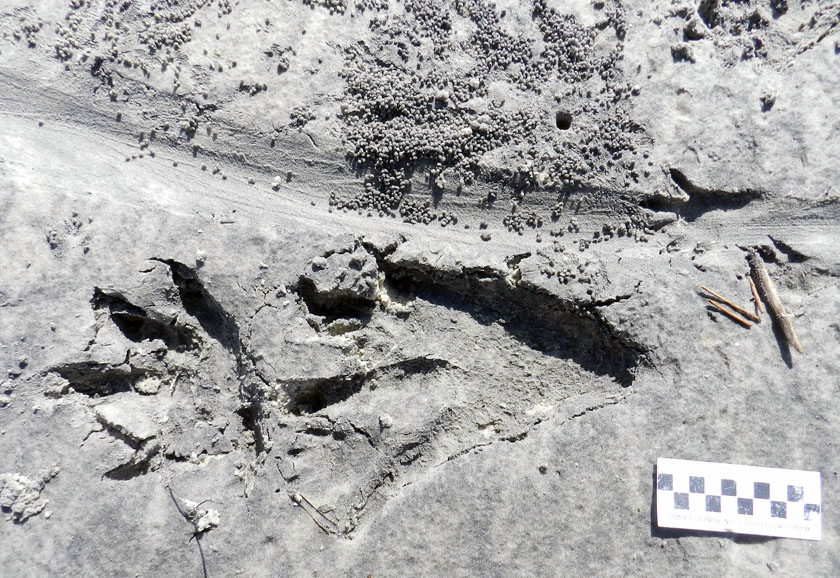
Otter-Tracks-Lope-Pattern-SapeloRiver otter (Lutra canadenis) tracks in what I (and some other trackers) call a “1-2-1” pattern. For gait, that translates into a “lope,” which is typical for an otter. In this pattern, one of the rear feet exceeds the front foot on one side, but the other rear foot ends up beside that same front foot; one front foot is behind. If that second rear foot lags behind the front foot, then it’s a “trot,” but if it exceeds the front foot (both rear feet ahead of both front feet), then that’s a “gallop.” Also, check out the wind ripples beneath the tracks, and raindrop impressions on top of them. (Photo by Anthony Martin, taken on Sapelo Island, Georgia; photo scale in centimeters, with the long bar = 10 cm (4 inches))

What made these tracks different was that they went on, and on, and on. These otter tracks spoke for the otter, saying in no uncertain terms that walking, trotting, loping, and galloping on a beach was the only thing it had on its schedule that morning. For nearly a kilometer (0.6 miles), we followed its tracks in the sandy strip of land between the high-tide line on the right and low coastal dunes on the left.

River-Otter-Tracks-Sapelo-Beach-2

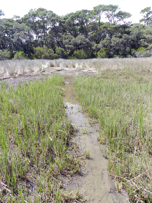
Follow the river otter tracks for as far as you can in this photo. Then, when you can’t see them any more, decide where it went. Does that sound like a challenge? It probably would be if you’ve only written about tracking otters, but it can be tough for experienced trackers, too. (Photo by Anthony Martin, taken on Sapelo Island, Georgia.)

The tracks were only a few meters away from high tide, but sometimes turned that way, vanished, then reappeared further down the beach. This told us the otter was out close to  peak tide that morning (between 6-8 a.m.) and was mixing up its exercise regime by occasionally dipping into the surf. Raindrop impressions on top of the tracks confirmed this, as the tracks looked crisp and fresh except for having been pitted by rain. For us, rain started inland and south of there on the island around 10 a.m., but reached the tracks sooner than that. We were there about three hours after then, so the otter was likely long gone, on to another adventure. Nonetheless, we made sure to look up and ahead frequently, just in case the trackmaker decided to come back to the scene of his or her handiwork.

For those of you who are intrigued by animal tracks (and why would you not be?), I suggest you try following those made by one animal, and follow it for as long as you can. That way you can learn much more about it as an individual animal, rather than just its species name. In my experience, after tracking an animal for a long time, nuances of its behavior, decisions, and even its personality emerge.

For example, this otter was mostly loping (its normal gait), but once in a while slowed to a walk or trot, or sped up, when it galloped. In short, the tracks showed enough variations to say that the otter was likely reacting to stimuli in its surroundings, and in many different ways. What gave it a reason to slow down? What impelled it to move faster? Why did it jump into the surf when it did, and why did it come out? Or, do otters just want to have fun?
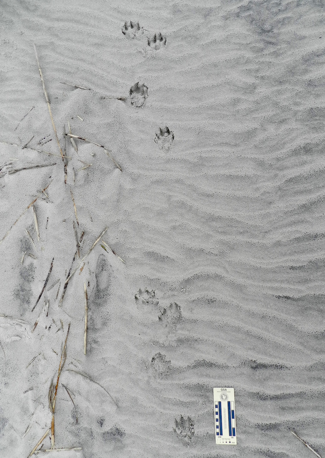
River-Otter-Gallop-Pattern-SapeloGallop pattern for a river otter, in which both of its rear feet exceeded the front feet, making a group of four tracks. In this instance, the group defines a “Z” pattern when drawing a line from one track to another, but gallops sometimes also produce “C” patterns. Notice also how the groupings are separated by a space with no tracks. This is also diagnostic of a gallop pattern: the longer the space, the longer the “air time” for the animal, when it was suspended above the ground between when its feet touched the ground. (Photo by Anthony Martin, taken on Sapelo Island, Georgia.)

Now I realize that discerning a “personality” and “moods” of a non-human animal based on a series of its tracks might sound like a little too “woo-woo” and “New Agey” for my skeptical scientist friends to accept, followed by jokes about my becoming a pet psychic. As a fellow skeptical scientist, I’m totally OK with that. In fact, I will join them in making fun of people who try to tell us that, say, they know what a Sasquatch was thinking as it strolled through a forest while successfully avoiding all cameras and other means of physical detection.

But here’s what happens when you’ve tracked a lot (which I have) and made lots of mistakes while tracking, but later corrected them (ditto). Intuition kicks in, and it usually works. For instance, at one point in following this otter, I lost its tracks on a patch of hard-packed sand. (Granted, I should have gotten down on my hands and knees to look closer, but was being lazy. Hey, come on, I was on a writer’s retreat.) So I then asked myself, “Where would I (the otter) have gone?” and looked about 10 meters (30+ feet) ahead in what felt like the right place. There they were. This happened three more times, results that led me to conclude this was almost like some repeatable, testable, falsifiable science-like thing happening. So there.
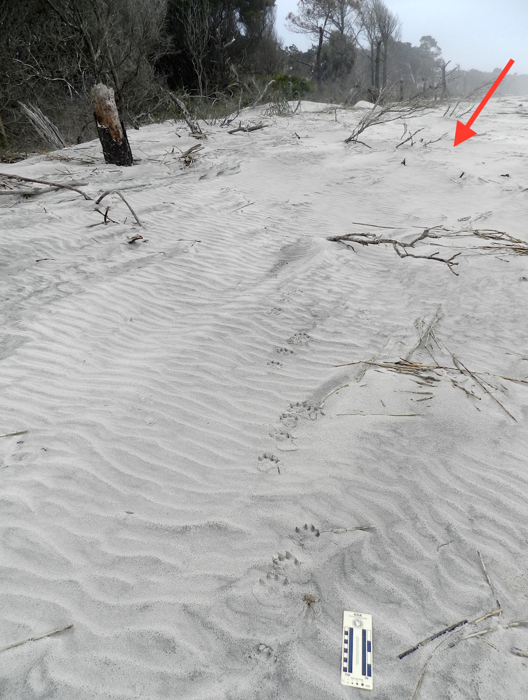
River-Otter-Tracks-Sapelo-Beach-2-LabeledOK, remember when I asked you to follow the river otter tracks for as far as you could in this photo, and when you couldn’t see them any more, decide where it went? If not, go back and re-read it and look at the photo again. If you have, then look at the red arrow, backtrack to the footprints in the foreground of the photo, then go forward. Do you see how the tracks are staying in the subtly lower area, just left of the slightly higher sand piled on the plant debris? Keep picking out those low areas, and you’ll end up where the arrow is pointing. After all, if I were an otter, that’s where I would go. (Photo by Anthony Martin, taken on Sapelo Island, Georgia.)

Oh yeah, regarding my main topic sentence: What’s all this have to do with writing about a place? Well, because of that otter and its tracks, I now understand at least one otter much better than before, and feel like I can write with a little more authority about otters in general. You know, like what you just read.
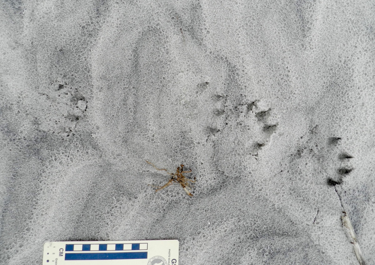
Otter-Tracks-Lope-Pattern-Sapelo-2Do you understand this river otter and its place a little better now, thanks to it leaving so many tracks while it enjoyed a morning at the beach, and because I tracked it for such a long time, and then wrote about that experience in that same place? Please say “yes,” as I want to keep writing about stuff like this. P.S. Thanks to Sapelo Island, this river otter, and my wife Ruth for teaching me so much yesterday. (Photo by Anthony Martin, taken on Sapelo Island, Georgia.)

Ballast of the Past

While strolling through the beautiful and historic city of Savannah, Georgia last week, I made sure to pay attention to the thousands of time machines below my feet. Yes, I know, everyone other than geologists stubbornly refer to these objects as “rocks.” Fortunately, though, we earth scientists don’t have to limit our imaginations by using such simplistic labels. These pieces of a pre-human past all have stories to tell of their origin, and sometimes they even connect to our treatment of one another as human beings.

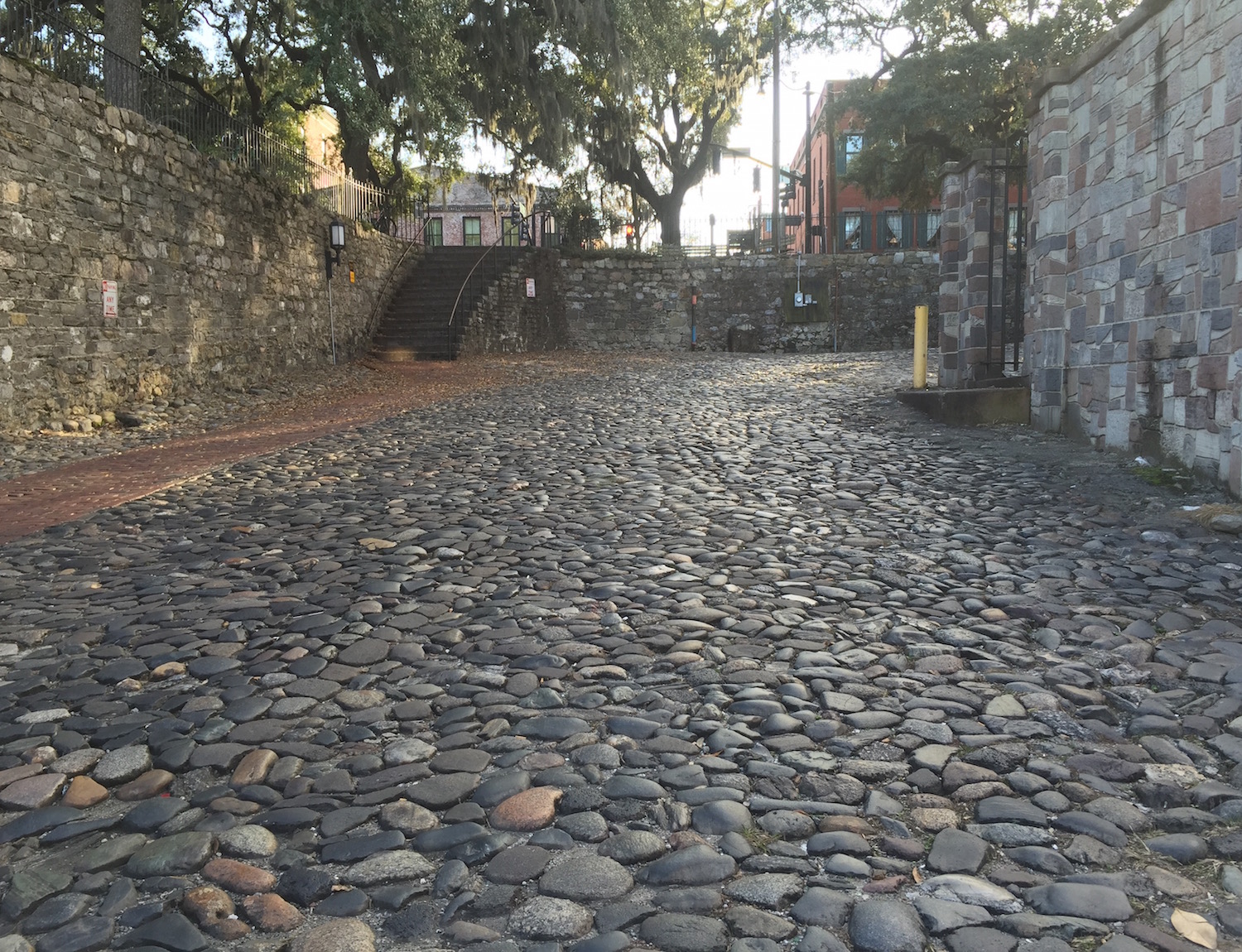
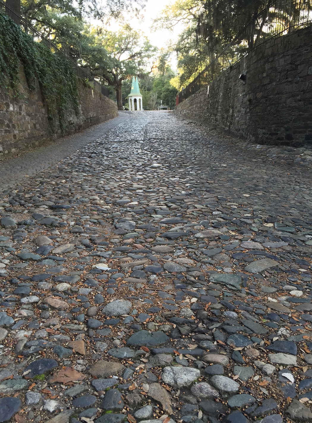
Ballast-Stones-Street-Wall-SavannahA street on the north edge of Savannah, Georgia leading down to the Savannah River, composed of rocks from afar. How did these rocks get there, and what stories do they tell us about themselves and us? (Photo by Anthony Martin.)

Temporal considerations aside, the rocks of Savannah don’t really belong there. This is especially true for those on the north end of town cobbling the roads and reinforcing walls next to the Savannah River. A quick glance at these stones by the geologically informed reveals how these are all foreign to this part of Georgia. Sure enough, most are from across the Atlantic Ocean, with the majority probably originating in the British Isles. Yet they also have been part of Savannah history for at least a few hundred years. What are they, how did they get there, and why are they there?

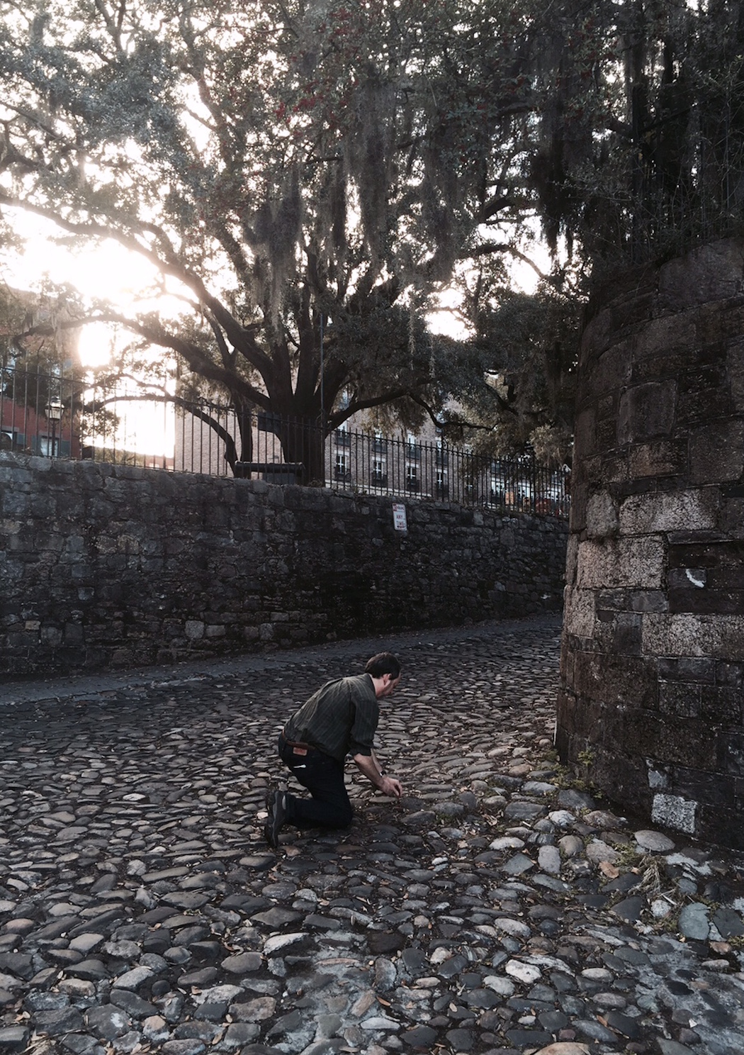
Studying-Ballast-Stones-SavannahA fine example of how rocks and a geologist (me, in this instance) get along just fine, especially when that geologist kneels in their presence. Note also the stone walls on either side of the street, which also figure into the origin story of these stones. (Photo by Ruth Schowalter.)

These are ballast stones, which filled the holds of ships during the 18th and 19th centuries as they sailed across the Atlantic Ocean from England. Were these ships exporting rocks to eager colonists who wished to collect nostalgic (and solid) reminders of their former homelands? No, ballast stones were used to keep ships weighted down, which helped to stabilize them as they moved across seas both calm and rough.

Once a ship reached Savannah – which began as a British settlement in 1733 – its crew would dump its rocky cargo and replace its relatively uneconomic value with goods grown in Georgia, such as rice, cotton, and indigo. Those economic commodities then went across the ocean, where they were used for food (rice) or textiles (cotton and indigo). Meanwhile, the ballast stones were repurposed as durable materials for the streets, walls, and houses along the Savannah River, as well as in some of the older homes in the historic district of Savannah.

The rocks on the streets and in the walls of Savannah are amazingly varied, reflecting the geological diversity of the United Kingdom and perhaps other places. (Admittedly, I haven’t done an exhaustive literature search on this topic yet: This is only a blog post, y’all.) Igneous, metamorphic, and sedimentary rocks are all represented, but perhaps the most common type I saw was basalt, which is a black, fine-grained extrusive (volcanic) igneous rock.

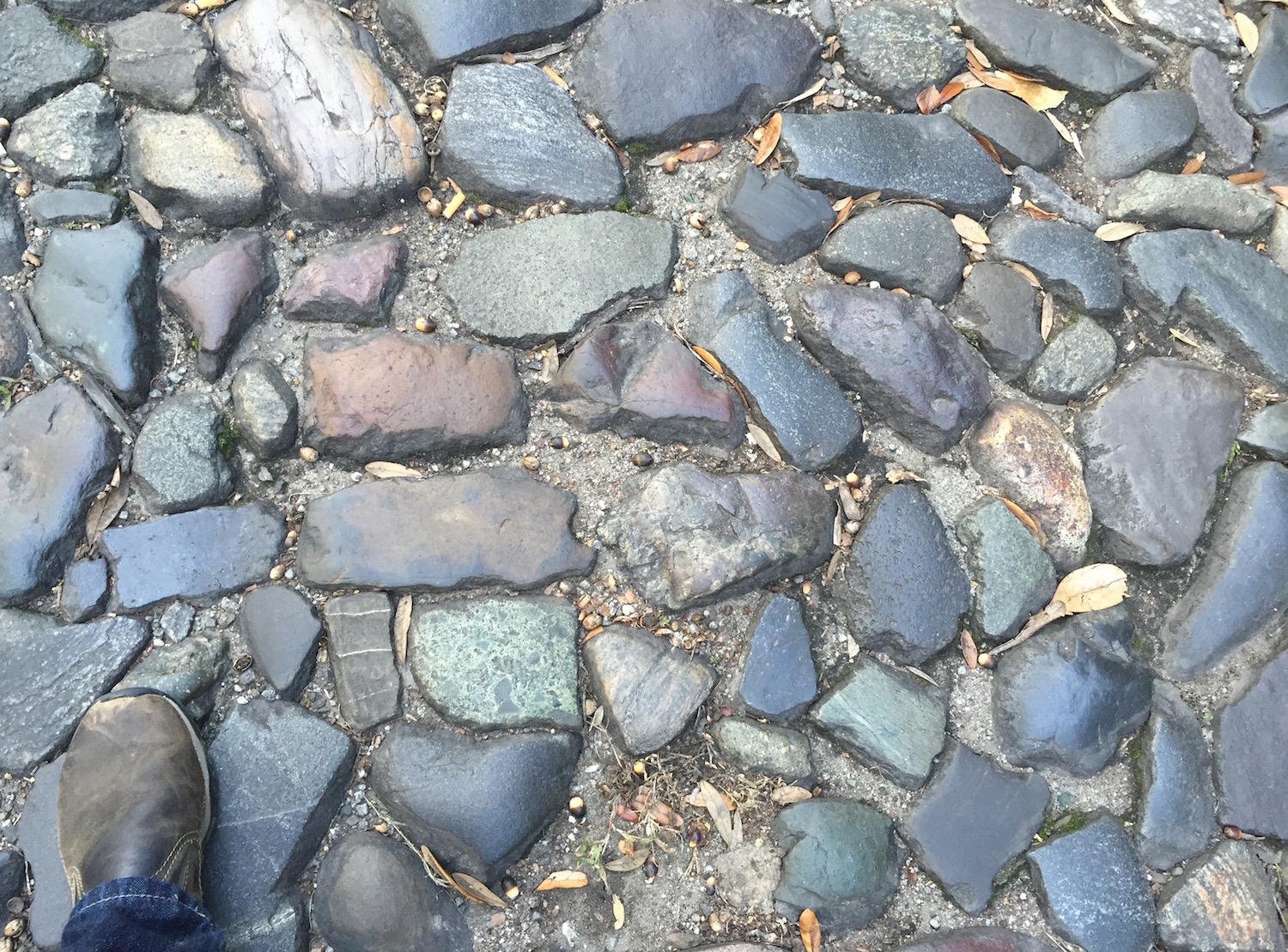
Ballast-Stones-Savannah-Close-UpA nice sample of the geologically diverse rocks composing a street in downtown Savannah, Georgia. Geologists glancing at this photo will no doubt spot representatives of the Holy Trinity of Lithology in this assemblage: Igneous, Metamorphic, and Sedimentary. Amen! (Scale = size 8 1/2 shoe (mens); photo by Anthony Martin.)

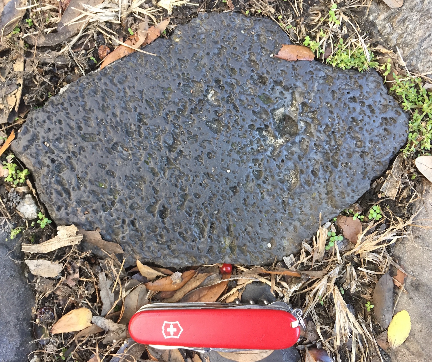
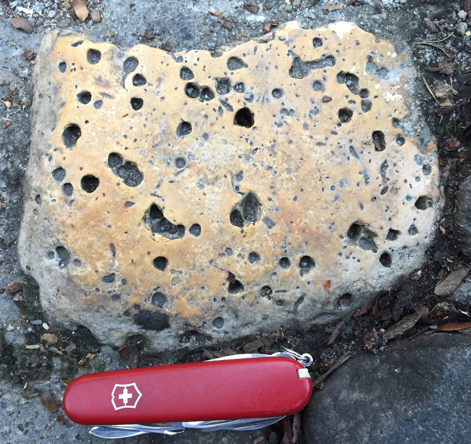
Ballast-Stone-Basalt-SavannahA good example of vesicular basalt, an igneous extrusive (volcanic) rock that formed from hot magma that cooled at or near the surface of the earth, and nowhere near present-day Savannah. The “vesicular” part of its name is from vesicles formed by gases in the magma, evidenced by those little holes in the rock. (Photo by Anthony Martin.)

However, I also saw intrusive (plutonic) igneous rocks, at least one of which was intruded by basalt, defined by a clean, black band cutting across the older rock. Sedimentary rocks included sandstones, some of which were placed parallel to their original bedding, fitting like bricks in some of the walls above the street.

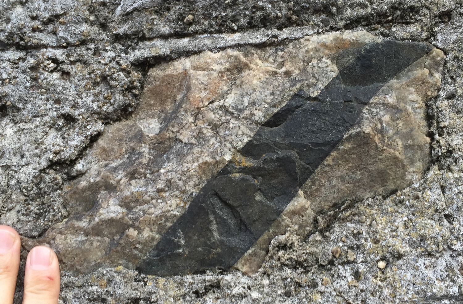
Ballast-Stone-Basalt-Crosscutting-Intrusive-SavannahForget paper and scissors: This time, rock cuts rock. The black band is a basalt dike, which is cutting across the coarser-grained igneous rock, which may be a pegmatitic granite. Based on the simple principle of cross-cutting relations, the basalt is geologically younger than the pegmatite. (Photo by Anthony Martin.)

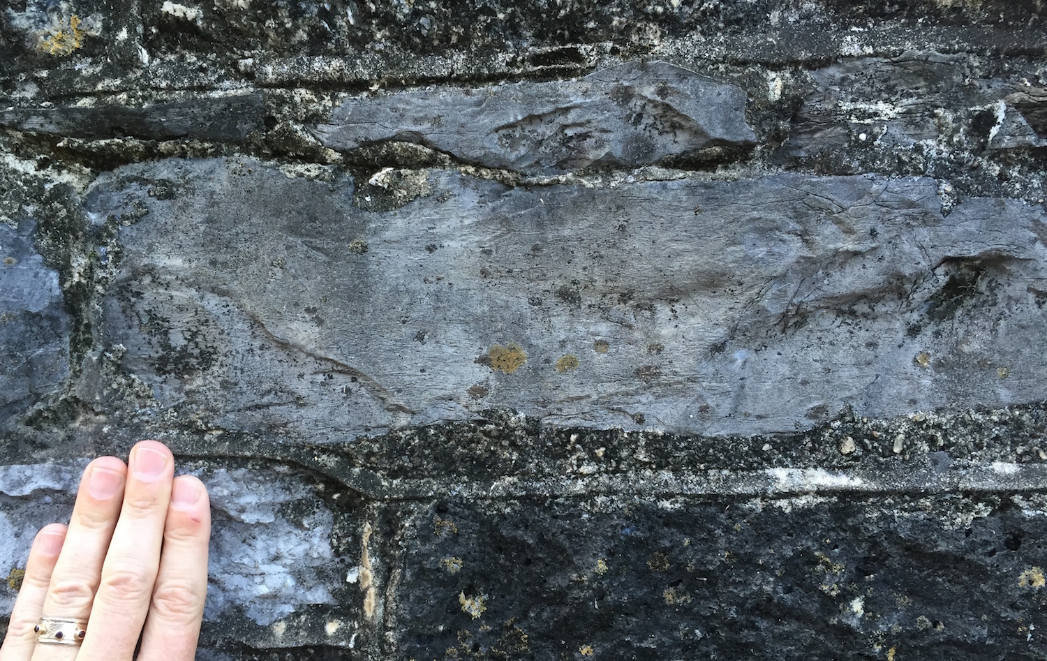
Ballast-Stone-Sandstone-SavannahAs a sedimentary geologist, I’m always happy to see a sedimentary rock, and this one was no exception. This sandstone had some low-angle cross-bedding, which was likely made by the sorting of sand, moved and deposited by water millions of years ago. (Photo by Anthony Martin.)

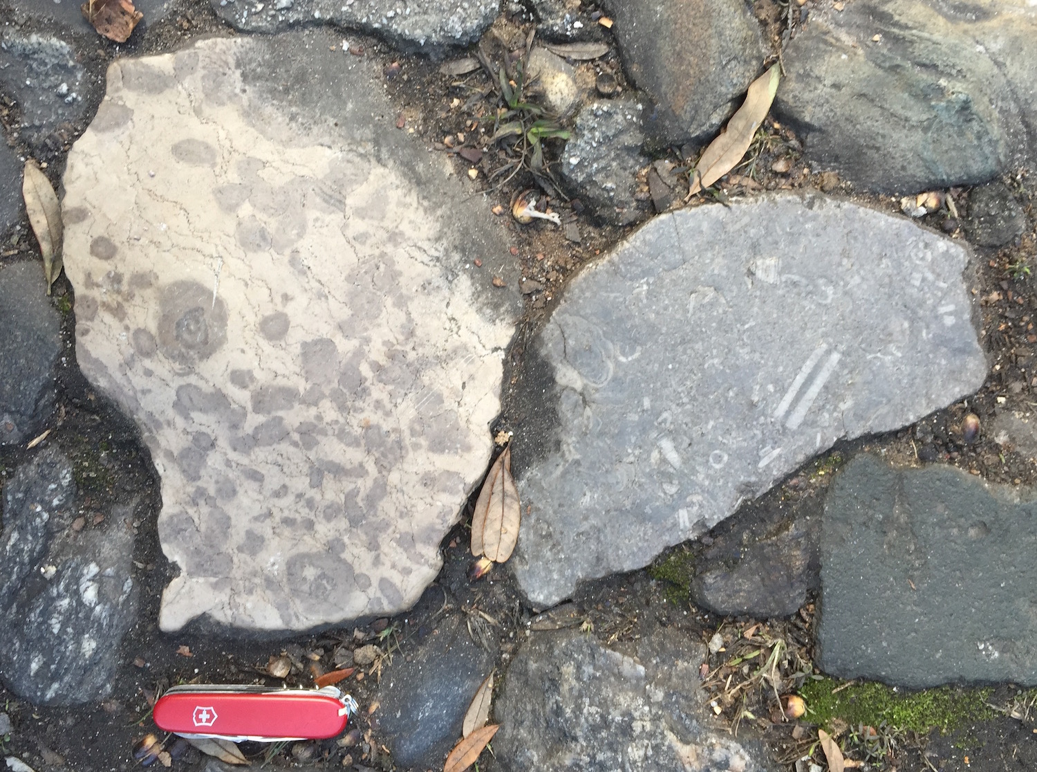
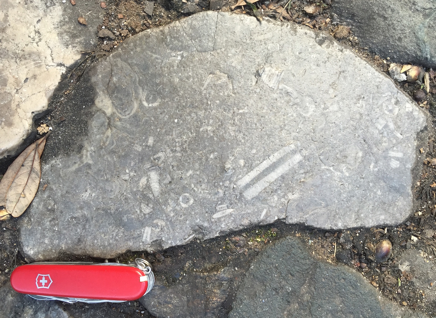
At least a few sedimentary rocks even contained fossils, such as a limestone with gorgeous length-wise and cross-sections of crinoid stems. This one was probably from the Carboniferous Period, from more than 300 million years ago. It was next to another limestone containing what looked to me like cyanobacterial or algal structures, called oncolites. Such rocks were common earlier in the Paleozoic Era, say, 450-500 million years ago.

Ballast-Stones-LimestonesLimestones from another land, but now paving a street in Savannah, Georgia. The one on the left bears what I think are algal structures called oncolites, and the one on the right has nicely preserved crinoid parts. Where are they from, and what are their geological ages? I can only answer “Great Britain” for the former, and “Paleozoic” for the latter. But I suspect the oncolititic limestone is older (Cambrian) than the crinoidal limestone (Carboniferous). At any rate, these rocks are not from the Savannah area, which is composed of sands and muds from much more recent rivers and tides.

Ballast-Crinoidal-LimestoneA close-up of that crinoidal limestone, with the length-wise section of a crinoid stem (center bottom) and cross-sections of their columnals throughout. (Photo by Anthony Martin.)

So like most normal people, you are probably wondering how these ballast stones relate to ichnology. For instance, do any of the sedimentary rocks contain trace fossils? Maybe, although I didn’t see any really convincing ones. Only one rock of the many I examined had some possible vertical burrows, exposed as holes in a sandstone cobble.

Ballast-Stone-Trace-Fossils-SavannahA sandstone with some good candidates for trace fossils, in which the holes may be cross-sections of vertical burrows. It may even have a U-shaped burrow, which looks like a little dumbbell when viewed from above (upper right). Sadly, out of all the rocks I saw on the street, I didn’t see any others like this, so I wasn’t able to test my hypothesis any further. (Photo by Anthony Martin.)

But there is another trace here, one much larger and more conceptual than what can be discovered in a single stone. Think of how these ballast stones collectively represent a human trace, tangible evidence of a grand transference of geological heritage from one continent to another.

From more of a moral perspective, however, these ballast stones are also a trace of slavery. The labor of enslaved people – abducted from their homes in western Africa and, like ballast stones, packed into cargo holds on ships and taken to a foreign land – produced the agricultural goods that went back in ships to Europe.

Although slavery was at first banned from Savannah, it was allowed soon after its founding (starting in 1750) and continued after American independence in the latter part of the 18th century. Savannah one of the most productive ports in the world for the shipping of rice and cotton during the antebellum times in the 19th century, and the heinous exploitation of human lives continuing until the advent of the American Civil War in the mid-1860s. This meant more ships arriving over the years, still bringing their ballast stones, and taking back cotton, rice, and other fruits of this cruel labor. Meanwhile, slave labor was also used to construct many of the streets, walls, and homes in Savannah composed of ballast stones.

Ballast-Stones-Street-Walls-Savannah-2A Savannah street and walls, built with rocks from another land, and by people from another land, some of whom did not have a choice in building them.

So there would be far fewer ballast stones on the streets and in the walls of Savannah if not for this brutal part of English and American history. The legacy of these stones also links to the family lineages of millions of African Americans, whether they live in Savannah, other parts of Georgia, the U.S., or abroad. As we walk on these rocks in the streets of Savannah, I am mindful of how their physical weight later became an emotional one, one still carried by many of us as we view and walk on these traces of that past.

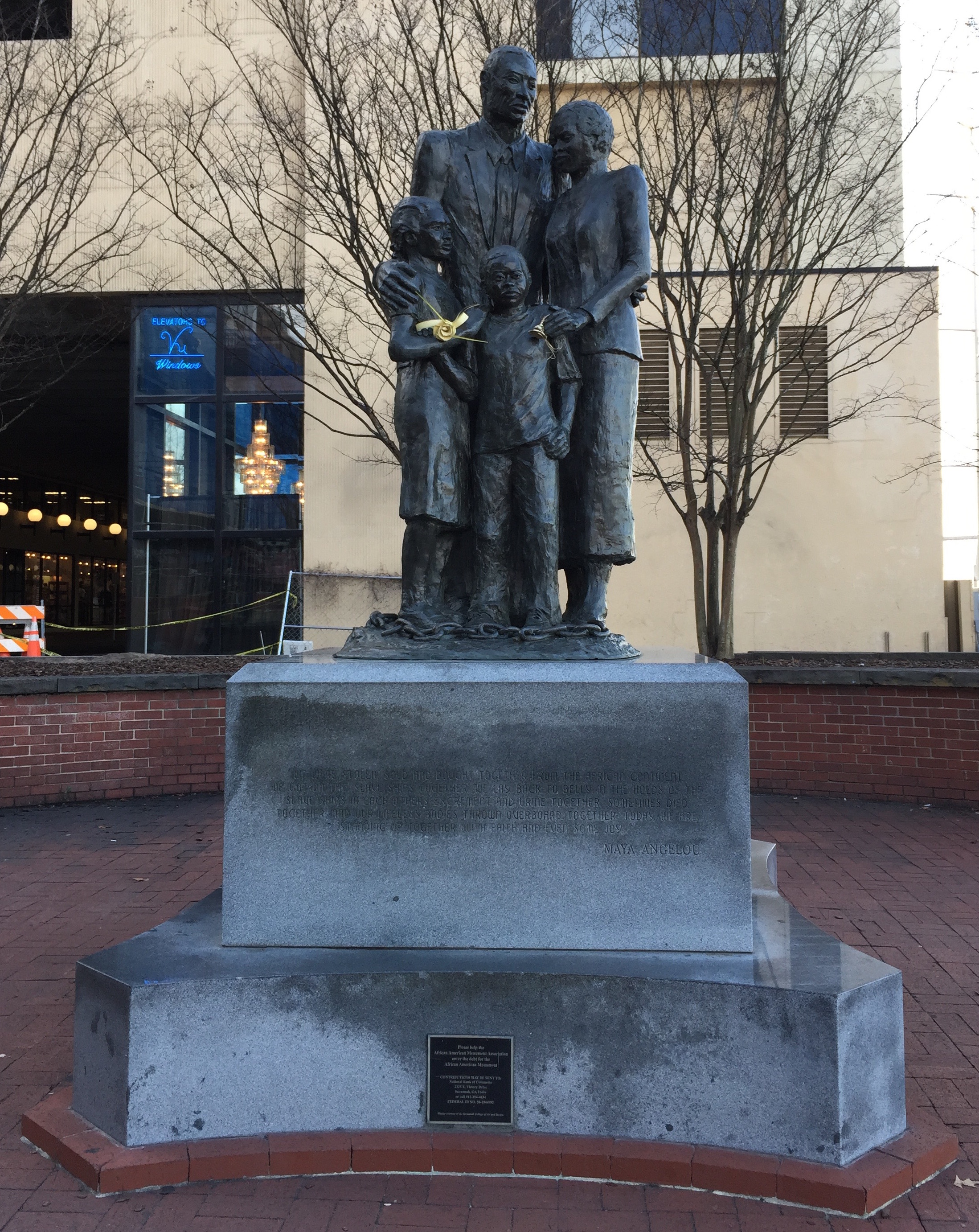
IMG_2738African American Family Monument, a bronze sculpture designed by Dorothy Spradley, on River Street in Savannah, Georgia. The foundation – which I think is  composed of more geographically appropriate granite from Elberton, Georgia – is inscribed with the following words by Maya Angelou (1928-2014), which, like the ballast stones, remind us of a past we might like to forget, but should not.

We were stolen, sold and bought together from the African continent. We got on the slave ships together. We lay back to belly in the holds of the slave ships in each others excrement and urine together, sometimes died together, and our lifeless bodies thrown overboard together. Today, we are standing up together, with faith and even some joy.

(For a bit more information about Savannah’s ballast stones, and to see them for yourself while visiting Savannah – which I highly recommend – visit the Historical Markers Database site at Savannah’s Cobblestones.)

Acorns, Mighty Oaks, and Raccoons

Despite more than 15 years of visiting the Georgia coast, studying its traces, and taking students on field trips to its barrier islands, I always marvel at how each trip is different, bestowing new insights and lessons to both me and my students. So a trip there this past weekend was no exception, and perhaps the most intriguing phenomenon I encountered during it was of some “mere” scrapings in a sandy road on Wassaw Island, Georgia.

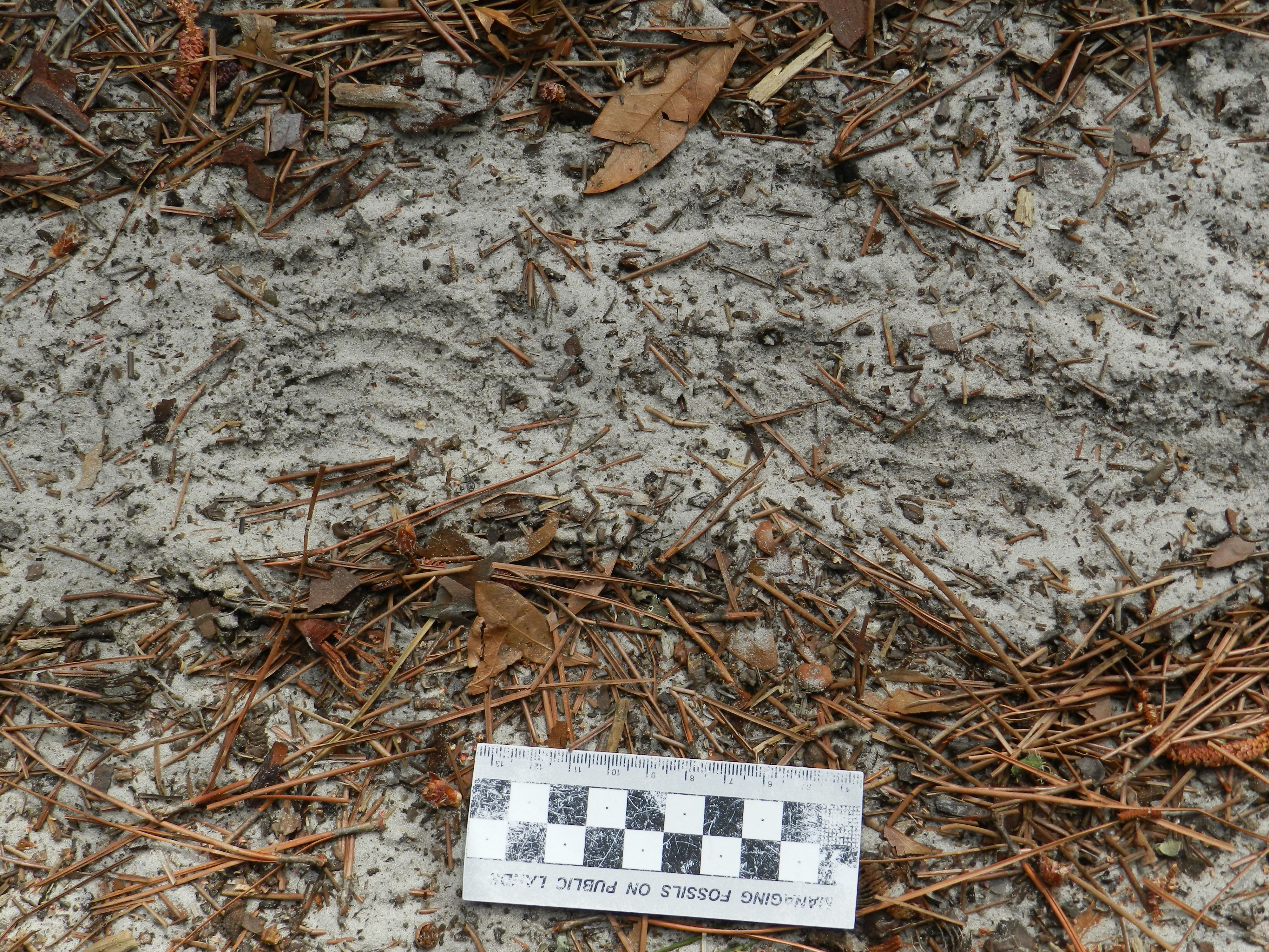
Raccoon-Scrapings-Acorns-WassawWho needs a Mystery Date when you can have a Mystery Trace? Here we have some enigmatic scrapings in a sandy road on Wassaw Island, Georgia. What could have made these, and why? (Photograph by Anthony Martin; scale in centimeters.)

Wassaw Island is a National Wildlife Refuge, and I’ve mentioned it before as the one island of the Georgia coast that most closely approaches the ideal of “pristine,” a label blithely applied to nearly any Georgia barrier island regardless of how much humans had modified their landscapes. Current estimates are that it Wassaw only about 600 years old, which means that Native Americans had barely populated it by the time the Spanish arrived in the 16th century. Thus whenever I teach my biannual Barrier Islands class, I like to include a field trip to Wassaw Island so my students can appreciate the close-to-natural state of its ecosystems. We then contrast their experiences there by visiting overdeveloped Tybee Island on the same weekend, giving my students the opportunity to think about “before and after” conditions of Georgia barrier-island ecosystems.

Even better for my students, our leader for the field trip to Wassaw was not me, but John “(“Crawfish”) Crawford, one of the most knowledgeable naturalists on the Georgia coast. Employed by the University of Georgia Marine Extension Service on Skidaway Island, John regularly takes groups on an open boat to Wassaw Island for day trips. These trips never disappoint for the sheer variety and richness of natural history learned along the way, whether on the boat trip there and back, or on the island itself. I’ve been to Wassaw four times with John as a guide, and each time with him have seen something novel there. (I mean, how often do you see a decapitated seagull?)

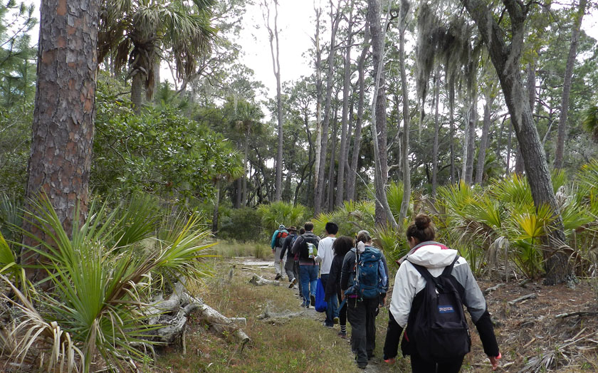
Wassaw-Interior-HikingInto the Woods, Wassaw Island style! With our intrepid guide (John “Crawfish” Crawford) leading the way into the maritime forest of Wassaw, my students were in for a world of discovery on this beautiful Georgia barrier island. (Photograph by Anthony Martin.)

Just one example from this most recent trip I’d like to share are traces I have never before seen, or, more likely, never before noticed. We encountered it while walking down a sandy road on Wassaw used more often by deer and alligators than humans. The traces were systematic and widespread scrapings of the top few centimeters of the road, some of which resolved themselves as curved to linear features with finer grooves in their interiors. Because they did not match the feeding traces of feral hogs (Sus scrofa) or nine-banded armadillos (Dasypus novemcinctus), I was intrigued. Who made these, and why?

Raccoon-Scrapings-Acorns-WassawJust in case you missed it the first time, here’s that photo again. Yes, this will be on the exam: why do you even ask?

A closer look revealed the traces were overlapping sets pf five evenly spaced grooves, corresponding with five thin-fingered hands. These could only belong to the most dextrous, industrious, and resourceful denizens of maritime forests and other environments on the Georgia coast, raccoons (Procyon lotor). When I queried John about these traces, he confirmed that not only were they made by raccoons, but also were a result of their “mining” the sand. The raccoons, using their front paws, methodically raked the loose sand to expose shallowly buried acorns dropped by the many old and mighty oaks lining the road, indulging in an all-you-can-eat acorn feast.

DSCN4416Close-up of the same mystery trace seen in the previous photo, but this time more groovy. Check out the curving, parallel set of five grooves (left) and the partial track (right), telling us that a masked bandit left its mark. (Photograph by Anthony Martin; scale in centimeters.)

Although raccoons are infamously omnivorous, in winter months they depend on acorns for much of their diet. Thus considering that the Georgia coast was still in winter, and that a sub-freezing cold front had just passed through the area a few days before, it was not surprising to see this evidence of extensive acorn foraging.

OK, time to replace my floppy coastal-geologist hat with my more stylish paleontologist hat to ask this question: Would such traces preserve in the geologic record, and if so, would they be recognizable for both the tracemaker (raccoon) and behavior (foraging)? Probably not for both, as the loose quartz-rich sand in a maritime forest would have few chances of being buried intact and cemented in a way that would “freeze” the details needed to discern both tracemaker and its intent. Yet these traces would lend some insights to interpreting disturbed zones in the upper parts of fossil soils, especially those that might have preserved acorns or other nuts in them.

So next time you’re in a maritime forest during the winter and come across some odd scrapings in the road, take a closer look and ask yourself a few questions about them. Who made them? Why did they make them? How do these traces relate to the broader ecology of the area? Would they be preserved in the fossil record, and if so, could we properly interpret them? Then ask yourself what you’ll find next time you go to the same place and look just a little bit closer.

Erasing the Tracks of a Monster

Life can certainly imitate art, as can life traces. I was reminded of this last week while doing field work on St. Catherines Island (Georgia), and after encountering traces made by two very different animals, alligators and fiddler crabs. What was unexpected about these traces, though, was how they intersected one another in a way that, for me, evoked scenes from the recent blockbuster summer movie, Pacific Rim.

Alligator-Tracks-Fiddler-Crab-Burrows-1

Could these be the tracks of a kaiju, making landfall on the shores of Georgia? Sorry to disappoint you, but they’re just the right-side and very large tracks of an American alligator (Alligator mississippiensis), accompanied by its tail drag-mark, left on a sandy area next to a salt marsh. Note the scale impressions in its rear-foot track, a symbol of the awesome reptilian awesomeness of its tracemaker. But wait: what nefarious nonsense is happening to the tail drag-mark, which is being covered by tiny balls of sand? Who made that hole next to the drag-mark? And what the heck was a raccoon (Procyon lotor) doing in the neighborhood, leaving its track on the tail drag-mark? With such a monster on the loose, shouldn’t that raccoon be hiding in the forest? (Photo by Anthony Martin, taken on St. Catherines Island; scale in centimeters.)

For anyone who has not seen Pacific Rim, you can read what I wrote about its distinctive fictional ichnology here. But what came to my mind while I was doing field work was one of the themes expressed early on in the film: how quickly humanity returned to normalcy following a lull in attacks by gigantic monsters (kaiju) that emerged from the ocean, destroyed major cities, and killed millions of people. It reminded me of how horrific hurricanes can strike a coast, such as the 1893 Sea Islands Hurricane that hit Georgia, but because no hurricane like it has happened there since, coastal developers think it’s hunky-dory to start building on salt marshes.

But enough about malevolent evil as exemplified by kaiju and coastal developers: let’s get back to traces. Last week, I was on St. Catherines Island for a few days with my wife (Ruth) and an undergraduate student (Meredith) to do some field reconnaissance of my student’s proposed study area. The area was covered by storm-washover fans; these are wide, flat, lobe-shaped sandy deposits made by storm waves, which span from the shoreline to more inland on barrier islands. We were trying to find out what traces had been left on these fans – tracks, burrows, scrapings, feces, and so on – which would tell us more about the distribution and behaviors of animals living in and around the washover fans.

Alligator-Trackway-St-Catherines-2Part of a storm washover fan on St. Catherines Island (Georgia), with the sea to the left and salt marsh (with a patch of forest) in the background. Say, I wonder what made those tracks coming out of the tidal creek and toward the viewer? (Photograph by Anthony Martin.)

It didn’t take long for us to get surprised. Within our first half hour of walking on a washover fan and looking at its traces, we found a trackway left by a huge alligator, split in half by a wavy tail-drag mark. I recognized this alligator from its tracks, as I had seen them in almost exactly the same place more than a year before. Besides their size, though, what was remarkable about these tracks was their closeness to a salt marsh behind the washover fan. When we looked closer, we could see long-established trails cutting through the salt-marsh vegetation, which were the width of a large adult alligator.

Alligator-Trackway-St-Catherines-1That ain’t no skink: the distinctive tracks and tail drag-mark of a large alligator, strolling through a storm-washover fan and next to a salt marsh. You think these animals are “freshwater only”? Traces disagree. Scale = 10 cm (4 in). (Photograph by Anthony Martin, taken on St. Catherines Island, Georgia.)
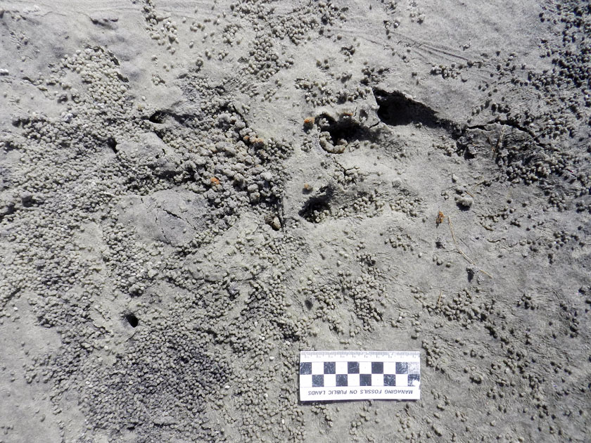
Alligator-Trail-Salt-Marsh-SCIAlligator trail cutting through a salt marsh. Trail width was about 45-50 cm (18-20 in), which is about twice as wide as a raccoon trail. And it wasn’t made by deer or feral hogs either, because, you know, alligators. (Photograph by Anthony Martin, taken on St. Catherines Island, Georgia.)
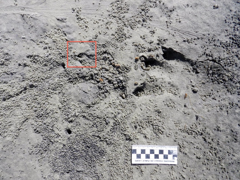
So although the conventional wisdom about alligators is that these are “freshwater-only” animals, their traces keep contradicting this assumption. Sure enough, in the next few days, we saw more alligator tracks of varying sizes going into and out of tidal creeks, salt marshes, and beaches.

Based on a few traits of these big tracks, such as their crisp outlines (including scale impressions), the alligator had probably walked through this place just after the tide had dropped, only a couple of hours before we got there. But when we looked closer at some of the tracks along the trackway, we were astonished to see that something other than the tides had started to erase them, causing these big footprints to get fuzzy and almost unrecognizable.

The culprits were sand fiddler crabs (Uca pugilator), which are exceedingly abundant at the edge of the storm-washover fans closest to the salt marshes. These crabs are industrious burrowers, making J-shaped burrows with circular outlines corresponding to their body widths. They also scrape the sandy surfaces outside of their burrows to eat algae in the sand, then roll up that sand into little balls, which they deposit on the surface.

In this instance, after this massive alligator had stomped through their neighborhood, they immediately got back to work: digging burrows, scraping the surface, and making sand balls. Within just a few hours, parts of the alligator trackway was obscured. If these parts had been seen in isolation, not connected to the clear tracks and tail drag mark, I doubt we would have identified these slight depressions as large archosaur tracks.

Alligator-Tracks-Burrowed-Fiddler-CrabsHey, what’s going on here? Who would dare to erase and fill in giant alligator tracks? Don’t they know who they’re dealing with? (Photograph by Anthony Martin, taken on St. Catherines Island, Georgia.)

Alligator-Tracks-Destroyed-Fiddler-Crab-Burrows-1Going, going, gone: alligator tracks nearly obliterated by burrowing, surface scraping, and sand balls caused by feeding of sand fiddler crabs (Uca pugilator). (Photograph by Anthony Martin, taken on St. Catherines Island, Georgia; scale in centimeters.)

What was even neater, though, was how some of the fiddler crabs took advantage of homes newly created by this alligator. In at least a few tracks, we could see where fiddler crabs had taken over the holes caused by alligator claw marks. In other words, fiddler crabs saw these, said, “Hey, free hole!”, and moved in, not caring what made them.

Alligator-Tracks-Destroyed-Fiddler-Crab-BurrowsDon’t believe me about fiddler crabs moving into alligator claw marks? OK, then what’s that I see poking out of that alligator claw mark (red square)? (Photograph by Anthony Martin, taken on St. Catherines Island, Georgia; scale in centimeters.)

Fiddler-Crab-Burrow-Alligator-Claw-MarkWhy, it’s a small sand fiddler crab! Does it care that its new home is an alligator claw mark? Nope. Does ichnology rule? Yup. (Photograph by Anthony Martin, taken on St. Catherines Island, Georgia.)
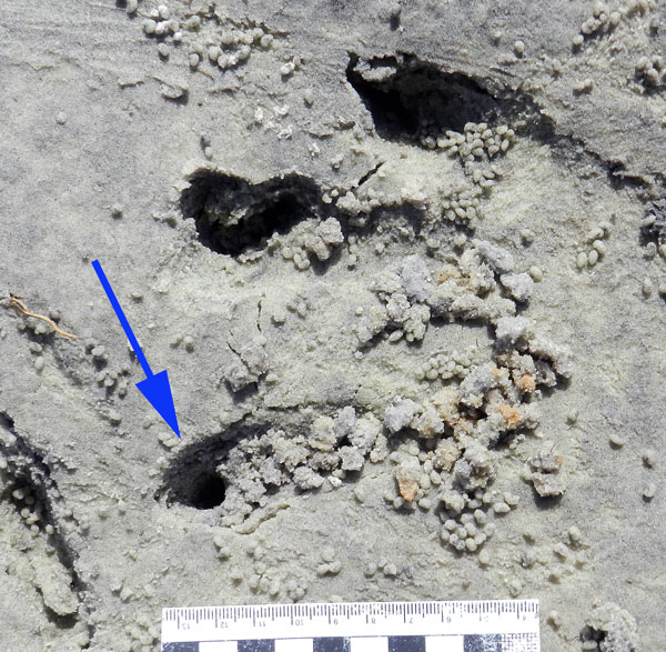
Fiddler-Crab-Burrow-Alligator-Claw-2Need a free burrow? Then why start digging a new one when alligator claw marks (arrow) gives you a nice “starter burrow”? Notice the sculpted, round outline, showing the claw mark was modified by a crab. Also check out the sand balls left outside of the other claw marks, meaning these have probably been occupied and mined for food by fiddler crabs, too. (Photograph by Anthony Martin, taken on St. Catherines Island, Georgia; scale in centimeters.)

As a paleontologist, the main lesson learned from this modern example that can be applied to fossil tracks, is this: any tracks made in the same places as small, burrowing invertebrates – especially in intertidal areas – might have been destroyed or otherwise modified immediately by the burrowing and feeding activities of those much smaller animals. The secondary lesson is on how large vertebrate tracks can influence the behaviors of smaller invertebrates, resulting in their traces interacting and blending with one another.

More symbolically, though, these alligator tracks and their erasure by fiddler crabs also conjured thoughts of fictional and real analogues: Pacific Rim and coastal development, respectively. With regard to the latter, it felt too much like how, as soon as a hurricane (a meteorological “monster”) passes through a coastal area, we begin to talk about rebuilding in a way that, on the surface, wipes out all evidence that a hurricane ever happened.

Yet unlike fiddler crabs, we have memories, we have records – including the plotted “tracks” of hurricanes – and thanks to science, we can predict the arrival of future “monsters.” So the preceding little ichnological story also felt like a cautionary tale: pay attention to the tracks while they are still fresh, and be wary of those that vanish too quickly.

The Ichnology of Pacific Rim

Last week I surrendered to geekdom peer pressure and went to see the new summer blockbuster Pacific Rim. Living up to my namesake, St. Anthony, I normally don't have a problem resisting such temptations, and just wait to see a movie like this in some other format: DVD, Netflix, or the way movies were originally intended to be seen, on a tiny screen on the back of an airplane seat. But what really pushed me to go was the following image, only glimpsed for a few seconds in one of the trailers:

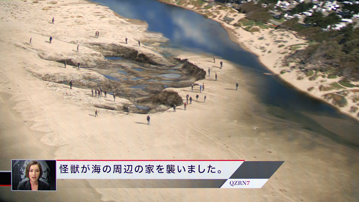
Kaiju-Track-IntertidalOoo, look, a trace made in an intertidal sandflat! Perhaps it's from a ghost crab, moon snail, or shorebird. Hey, wait a minute, something doesn't quite look right. Are those people next to it? (Image from http://www.comicbook.com.)

Yes, that’s right: it's a gigantic footprint, and in what looks like an intertidal coastal environment, between the low tide mark and coastal dunes. That was all the incentive I needed, as I further wondered what other ichnological wonders would be included in the film. I was also encouraged to see where other scientifically inclined bloggers had fun with Pacific Rim by taking a look at its biology (here, here, and most recently, here) and physics (here here, and most recently, here). So given a $5 afternoon matinee and a spouse (Ruth) willing to indulge my sci-fi inner nerd (OK, so it’s not so “inner”), I had every reason to document the various traces and tracemaking activities in the film. You know, for science and science education.

The verdict? Well, I have to admit some mild disappointment with how the director – Guillermo del Toro - chose to focus on the conflicts between massive amphibious creatures (kaiju) constructed by interdimensional aliens and human-guided fighting machines (jaegers), rather than on their traces. Nonetheless, I managed to find some ichnological gems scattered throughout. For example, the footprint shown in the trailer did indeed look glorious on a big screen, and the human figures associated with it reminded me of Jason Isley’s whimsical underwater photos. But let’s take a closer look at what this footprint tells us about its maker.

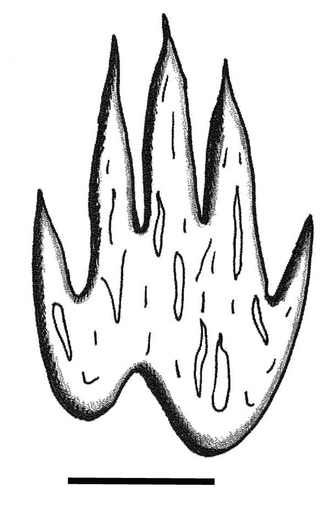
Although viewed from an oblique angle, the track seems longer than wide, and has four clearly defined digits, although a probable fifth digit is visible on the side farthest from the viewer. All of the digits are forward-pointing and taper abruptly at their ends. The tracks also has an indentation on the “heel” (proximal) part of the foot, and is more-or less-bilaterally symmetrical. Pits inside of the track may represent additional anatomical traits, such as scales or other bumps on its skin, or could be sediment that underwent liquefaction or other soft-sediment deformation.

Kaiju-TrackInterpreted kaiju track, extrapolated from oblique view. Scale = 10 m (33 ft).

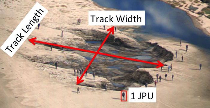
Using the people around the tracks as informal units of measurement, and assuming from the hiragana-katakana in the newscast image that this track - like many items - was made in Japan, we can estimate the dimensions of the track. Average heights for Japanese males and females are 1.71 m and 1.58 m, respectively, and the average of those is 1.64 m. Using one figure (boxed) as a unit that equals 1.64 m (5.4 ft), the footprint had about 18.4 Japanese-Person-Units (JPU) length and 10.1 JPU width, which converts to about 30 m (98 ft) long and 17 m (56 ft) wide. This results in a length:width ratio of about 1.8.

Kaiju-Track-MeasuredLength and width measurements for kaiju track, including figure used as 1.0 JPU = 1.64 m. Width measurement is assumed on basis of probable fifth digit impression on side of track furthest from the viewer.

Unlike in most articles published in high-impact journals, I'll actually admit potential sources of error in these measurements before I'm forced to retract this blog post under a cloud of scandal, followed by my accepting a high-paying position on Wall Street, where such inaccuracies are rewarded without penalty. For example, the width measurement, because it is being taken from an oblique angle (not so accurate) instead of from directly above (much more accurate) probably underestimates the actual width. So the actual width is probably closer to 20 m (67 ft), which reduces the length:width ratio to about 1.5. The length measurement would also benefit from more of an overhead view, and probably would best be studied using aerial high-resolution LiDAR scanning. So there.

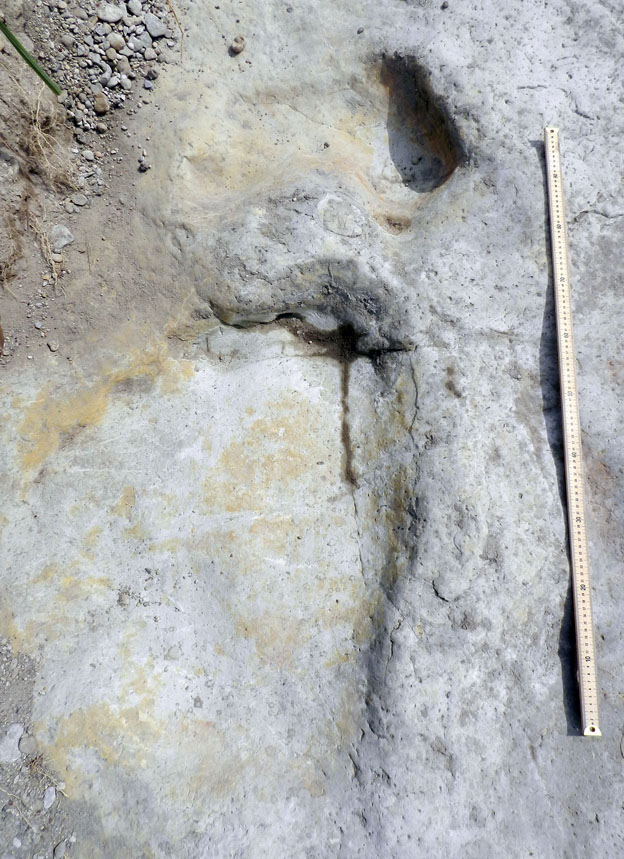
To put this in ichnological perspective, when these dimensions are compared to typical sauropod dinosaur tracks from the Early Cretaceous of Texas - where everything is supposed to be bigger - the sauropod comes out looking pretty puny indeed. In this example, the rear track length is 87 cm (34 in) and width is 59 cm (23"), and although its length:width ratio comes out fairly close to my estimation for the kaiju track (1.47), it is only about 2% of its size. Some "thunder lizard."

Sauropod-Tracks-TexasSauropod tracks from the Early Cretaceous (about 120-million-years-old) Glen Rose Formation of central Texas.The larger track is from the left rear foot, and the smaller one in front of it is the left front foot; this sauropod was walking slowly with an "understep" gait, in which its rear foot stayed behind its front. Please read the preceding text for all of that measurement stuff, which ichnologists sometimes call "data." (Photograph taken by Anthony Martin in Dinosaur Valley State Park, near Glen Rose, Texas.)

Kaiju+Sauropod-Tracks copyTo-scale comparison between sauropod track (arrow, lower left) and kaiju track (right) to same scale. Looks like some cute little saurischian would be feeling a little inadequate. As Cowboy Curtis once said on Pee Wee's Playhouse, "You know what they say: Big feet, big boots!" Scale = 10 m.

Speaking of high impact, how about track depth and other features of this individual track that might tell us about behavior of the kaiju tracemaker? Oddly enough, the kaiju track looks too shallow to me, measuring only about 1.6 JPU, or about 2.5 m (8 ft) deep. It also lacks pressure-release structures, which are sedimentary structures caused by the tracemaker applying and releasing pressure against the wall of the track. Considering that kaiju were supposed to weigh tens of thousands of tons, this track should have a greater depth, along with major ridges and plates outside of the track outline that would have been imparted by any forward or lateral movement of its foot.

Alternatively, this track may represent more of what I would call a “stamp,” which would have been made by placing a foot directly down onto a soft substrate and pulling it straight up, rather than from moving forward or laterally. Based on this evidence, the kaiju might have been attempting to squish pesky humans, rather thank performing its normal, forward-walking, city-destroying gait. Unfortunately, the preceding and next track are not shown in the photo, which would help to test this hypothesis.

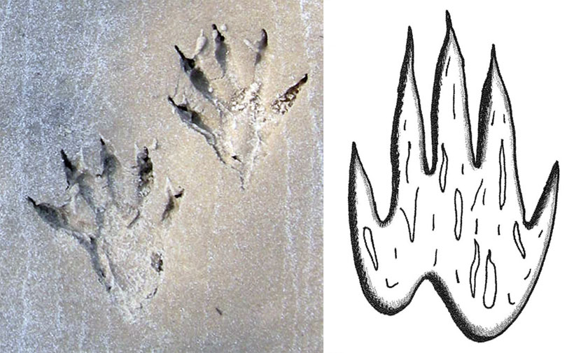
Other than size, how does the form of this track compare to those of other known dinosaur tracks? The length: width ratio comes out close to that of a sauropod dinosaur, yet other qualitative traits of the track, such as thin digits that taper and end with sharp clawmarks, are more like that of a theropod. But I do want to point out a little coincidence. Have you ever seen the front-foot track of a typical raccoon? Hmmm...

Raccoon+Kaiju-TracksI give you you raccoon tracks, and I give you kaiju track. That is all. (Photo of raccoon tracks taken by Anthony Martin on Cumberland Island, Georgia.)
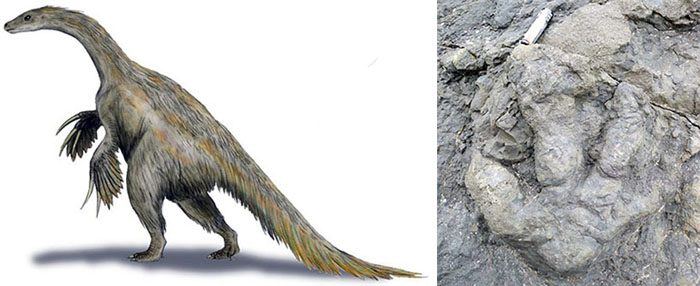
What’s really fun, though, is if you compare the kaiju track to known theropod tracks. Theropod tracks bearing four or more forward-pointing toes are quite rare, and the few identified probably belong to a group of theropods called therizinosaurs, which - by a strictly enforced paleo-nerd law - cannot be mentioned in a sentence without also using the descriptor "bizarre." Late Cretaceous dinosaur tracks recently reported from Alaska with four long, forward-pointing digits have been attributed to therizinosaurs. Were the creators of the kaiju track trying to compare it to that of a really strange theropod dinosaur? Maybe, maybe not.

Therizinosaur-Tamara-TrackArtistic rendition of Nothronychus mckinleyi, a therizinosaur from the mid-Cretaceous of North America (left) and a four-toed rear-foot track credited to a therizinosaur from Late Cretaceous rocks of Alaska (right). Therizinosaur artwork by paleoartist Nobu Tamara and available in Wikipedia Commons here; photo of track by David Tomeo and reproduced from Everything Dinosaur.

Although the Pacific Rim kaiju designers used a mix of invertebrate and vertebrate elements for anatomical details appearances of their monsters (detailed splendidly by Darren Naish here), I do wonder how they came up with the track, and which real-life animals - modern or extinct - were supposed to be evoked by this track's brief appearance onscreen. Hopefully the DVD and its Special Features will reveal all once that comes out.

(Incidentally, this attempt to divine the evolutionary relatedness of a science-fictional animal from a single track reminds me of a scene from the classic science-fiction film Forbidden Planet. At some point, an invisible monster comes aboard a spaceship on the aforementioned planet and kills its chief engineer. The ship scientist, Dr. Ostrow, then gave a fine interpretation of the monster based on a plaster cast made from one of its footprints, including how it traits seemed to go against all known evolutionary principles. It's such a fun scene, I've shown it in some of my classes as an example of "extraterrestrial ichnology.")

Other tracemaking in the movie, of course, included wholesale destruction of major population centers by the kaiju, clawmarks left on various city substrates, as well as kaiju scat. Unlike other fans of the movie, I've only seen it once so far, and cannot recall whether the following picture of its droppings was flashed on the movie screen or not.

What-a-load-of-kaiju-crapThe banner for this news clip says it all: kaiju excrement, and you can bet this much did indeed contaminate a portion of Manila, Philippines (or the "Phillipines," which may be a gated community just outside of Philadelphia.) On the flip side, I'll bet a certain sick Triceratops in the movie Jurassic Park is now a little less self-conscious about having its wastes piled higher and deeper on the big screen.

One line about their excrement – uttered by kaiju-organ harvester, Hannibal Chau (played by a hilarious Ron Perlman) - alludes to its commercial value based on its phosphorus content. This would accord with the economic importance given to bat or bird guano, which has been mined and sold as fertilizer, and even inspired wars. (I am not making that up.) Still, it would have been beyond awesome to have just one scene showing a deposit of its scat enveloping a large, recognizable monument to a politician in one of those cities.

Hannibal Chau (Ron Perlman), selling kaiju products for whatever might ail you. Alas, their scat is not mentioned in this ad, but he could easily do another one directed at Whole Foods. After all, it would be 100% organic and free-range fertilizer!

What about the jaegers? Their traces are much tougher to discuss, semantically speaking. Ichnologists classify tools themselves as traces of behavior, but most do not count marks made by tools (or machines) as traces. Nonetheless, because the jaegers are being controlled by humans, the marks they leave on the landscape, seascapes, and upside some kaiju’s head, might count as traces, too.

However, in one scene of the movie, in which a kaiju picked up a jaeger and threw it – inflicting much destruction of private and public property – these traces would be those of the kaiju, not the jaeger. I pointed out a similar situation with Jurassic Park. Toward the end of the movie, the poor, misunderstood protagonist of the film - the Tyrannosaurus rex - in an action tinged with self-loathing, hurled a Velociraptor at a mounted T. rex skeleton, no doubt expressing doubt about her place in a post-Mesozoic world. Existentialist angst aside, the destruction of the skeleton was a trace of the tyrannosaur's behavior, not that of the Velociraptor.

So next time you go to a movie featuring multi-ton monsters emerging from the deep sea and massive fighting machines, look for them to make traces, note the traces they make, how these traces may reflect some sort of evolutionary history for the tracemakers, and ask yourself what constitutes a trace. Then no matter how bad the movie, you'll still be guaranteed to enjoy it. Happy movie viewing and tracking!

The Paleozoic Diet Plan

Given the truth that the Atlantic horseshoe crab (Limulus polyphemus) is more awesome than any mythical animal on the Georgia coast (with the possible exception of Altmaha-ha, or “Altie”), it’s no wonder that other animals try to steal its power by eating it, its eggs, or its offspring. For instance, horseshoe-crab (limulid) eggs and hatchlings provide so much sustenance for some species of shorebirds – such as red knots (Calidris canutus) and ruddy turnstones (Arenaria interpres) – that they have timed their migration routes to coincide with spawning season.

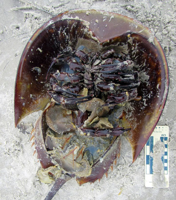
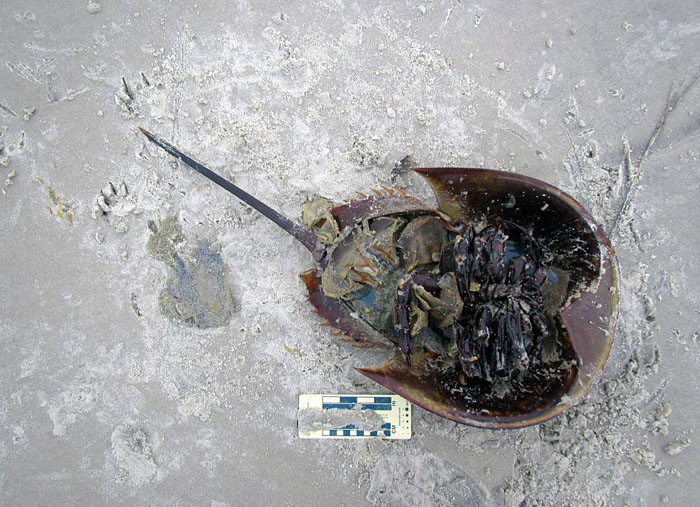
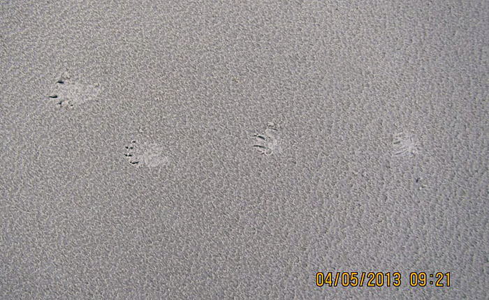
Ravaged-Limulid-SCISomething hunted down, flipped over, and ate this female horseshoe crab while it was still alive. Who did this, what clues did the killer leave, and how would we interpret a similar scenario from the fossil record? Gee, if only we knew some really cool science that involved the study of traces, such as, like, I don’t know, ichnology. (Photograph by Gale Bishop, taken on St. Catherines Island, Georgia, on May 4, 2013.)

Do land-dwelling birds mammals eat adult horseshoe crabs? Yes, and I’ve seen lots of evidence for this on Georgia beaches, but from only three species: feral hogs (Sus crofa) and vultures (Coragyps atratus and Cathartes aura: black vultures and turkey vultures, respectively). In all of these interactions, no horseshoe-crab tracks were next to their bodies, implying they were already dead when consumed; their bodies were probably moved by tides and waves after death, and later deposited on the beach. This supposition is backed up by vulture tracks. I’ve often seen their landing patterns near the horseshoe-crab bodies, which means they probably sniffed the stench of death while flying overhead, and came down to have an al fresco lunch on the beach.

Nonetheless, what I just described is ichnological evidence of scavenging, not predation. So I was shocked last month when Gale Bishop, while he was monitoring for sea-turtle nests on St. Catherines Island (Georgia), witnessed and thoroughly documented an incident in which a raccoon (Procyon lotor) successfully preyed on a live horseshoe crab. Yes, that’s right: that cute little bandit of the maritime forest, going down to a beach, and totally buying into some Paleozoic diet plan, a passing fad that requires eating animals with lineages extending into the Paleozoic Era.

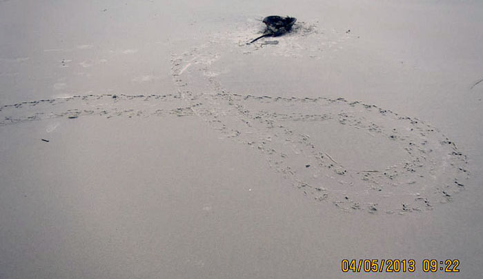
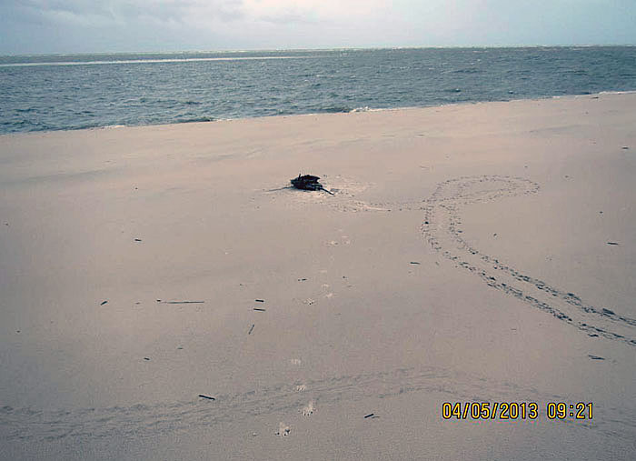
Limulid-Death-Spiral-SCISo what’s the big deal here? Horseshoe crab comes up on beach, gets lost, spirals around while looking for the ocean, and dies in vain, a victim of its own ocean-finding ineptitude: the end. Nope, wrong ending. For one thing, those horseshoe crab tracks are really fresh, meaning their maker was still very much alive, then next thing it knows, its on its back. Seeing that horseshoe crabs are not well equipped to do back-flips or break dance, I wonder how that happened? (Photograph by Gale Bishop, taken on St. Catherines Island, Georgia, and you can see the date and time for yourself.)

Here is part of the field description Gale recorded, which he graciously shared with me (and now you):

“Female Horseshoe Crab at 31.63324; 81.13244 [latitude-longitude] observed Raccoon feeding on upside-down HSC [horseshoe crab] on south margin of McQueen Inlet NO pig tracks. Relatively fresh HSC track. Did this raccoon flip this HSC?”

Raccoon-Tracks-Pee-Limulid-Eaten-SCIWell, well. Looks like we had a little commotion here. Lots of marks made from this horseshoe crab getting pushed against the beach sand, and by something other than itself. And that “something else” left two calling cards: a urination mark (left, middle) and just above that, two tracks. I can tell you the tracks are from a raccoon, and Gale swears the urination mark is not his. (Photograph by Gale Bishop, taken on St. Catherines Island, Georgia, and on May 4, 2013.)

I first saw these photos posted on a Facebook page maintained by Gale Bishop, the St. Catherines Island Sea Turtle Program (you can join it here). This was one of this comments Gale wrote to go with a photo:

GB: “This HSC must have been flipped by the Raccoon; that was NOT observed but the fresh crawlway indicates the HSC was crawling across the beach and then was flipped – only tracks are Rocky’s!”

[Editor’s note: “Rocky” is the nickname Gale gives to all raccoons, usually applied affectionately just before he prevents them from raiding a sea-turtle nest. And by prevent, I mean permanently.]

My reply to this:

AM: “VERY fresh tracks by the HSC, meaning this was predation by the raccoon, not scavenging.”

In our subsequent discussions on Facebook, Gale agreed with this assessment, said this was the first time he had ever seen a raccoon prey on a horseshoe crab, and I told him that it was the same for me. This was a big deal for us. He’s done more “sand time” on St. Catherines Island beaches than anyone I know (every summer for more than 20 years), and in all my wanderings of the Georgia barrier island beaches, I’ve never come across traces showing any such behavior.

(Yes, that’s right, I know you’re all in shock now, and it’s not that this was our first observance of this phenomenon. Instead, it is that we used Facebook for exchanging scientific information, hypotheses, and testing of those hypotheses. In other words it is not just used for political rants, pictures of cats and food, or political rants about photos of cat food. Which are very likely posted by cats.)

Now, here’s where ichnology is a pretty damned cool science. Gale was on the scene and actually saw the raccoon eating the horseshoe crab. He said it then ran away once it spotted him. (“Uh oh, there’s that upright biped with his boom stick who’s been taking out all of my cousins. Later, dudes!”) And even though I trust him completely as a keen observer, excellent scientist, and a very good ichnologist, I didn’t have to take his word for it. His photos of the traces on that Georgia beach laid out all of the evidence for what he saw, and even what happened before he got there and so rudely interrupted “Rocky” from noshing on horseshoe-crab eggs and innards.

Raccoon-Galloping-Limulid-Death-Spiral-Traces-SCIAnother view of the “death spiral” by the horseshoe crab, which we now know was actually a “life spiral” until a raccoon showed up and updated that status. Where’s the evidence of the raccoon? Look in the middle of the photos for whitish marks, grouped in fours, separated by gaps, and each forming a backwards “C” pattern. Those are raccoon tracks, and it was galloping away from the scene of the crime (toward the viewer).

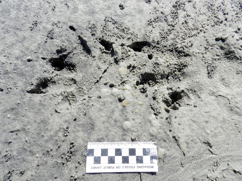
Raccoon-Galloping-Pattern-SCISo you don’t believe me, and need a close-up of that raccoon gallop pattern? Here you go. Both rear feet are left, both front feet are right, and the direction of movement was to the left; when both rear feet exceed the front, that’s a gallop, folks. Notice the straddle (width of the trackway) is a lot narrower than a typical raccoon trackway, which is what happens when it picks up speed. When it’s waddling more like a little bear, its trackway is a lot wider than this. Conclusion: this raccoon was running for its life.

Although this is the only time Gale has documented a raccoon preying on a horseshoe crab – and it is the first time I’ve ever heard of it – we of course now wonder whether this was an exception, or if it is more common that we previously supposed. The horseshoe crab was a gravid female, and was likely on the beach to lay its eggs. Did the raccoon somehow know this, and sought out this limulid so that – like many shorebirds – it could feast on the eggs, too, along with some of the horseshoe crab itself? Or was it opportunistic, in that it was out looking for sea-turtle eggs, saw the horseshoe crab, and thought it’d try something a little different? In other words, had it learned this from experience, or was it a one-time experiment?

All good questions, but when our data set is actually a datum set (n = 1), there’s not much more we can say about this now. But given this new knowledge, set of search patterns, and altered expectations, we’re more likely to see it again. Oh, and now that you know about this, so can you, gentle reader. Let us know if you see any similar story told on the sands of a Georgia beach.

You want one more reason why this was a very cool discovery? It shows how evolutionary lineages and habitats can collide. Horseshoe crabs are marine arthropods descended from a 450-million-year-old lineage, and likely have been coming up on beaches to spawn all through that time. In contrast, raccoons are relative newcomers, coming from a lineage of land-dwelling mammals (Procyonidae) that, at best, only goes back to Oligocene Epoch, about 25 million years ago. When did a horseshoe crab first go onto land and encounter a land-dwelling raccoon ancestor? Trace fossils might tell us someday, especially now that we know what to look for.

So once again, these life traces provided us with a little more novelty, adding another piece to the natural history of the Georgia coast. Moreover, a raccoon preying on a horseshoe crab was another reminder that even experienced people – like Gale, me, and others who have spent much time on the Georgia barrier islands – still have a lot more to learn. Be humble, keep eyes open, and let the traces teach you something new.

(Acknowledgement: Special thanks to Dr. Gale Bishop for again spotting something ichnologically weird on St. Catherines Island, documenting it, and sharing what he has seen during his many forays there.)

Ghost Shrimp Whisperer

When you hear the word “shrimp,” you probably picture those that show up in grocery stores and restaurants throughout the world, which are then consumed voraciously by their terrestrial admirers. Also, some recent attention has been given to mantis shrimp, and deservedly so, because they are among the most gorgeous and terrifying of marine invertebrates today. But there are other marine crustaceans bearing the name “shrimp” that are neither gracing seafood buffets nor awesome predators, yet are worthy of our adoration, documentary films, and epic songs, the latter of which will be no doubt performed on Eurovision 2014. Yes, you guessed it: I’m talking about ghost shrimp.

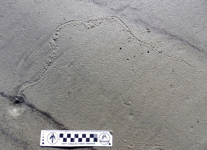
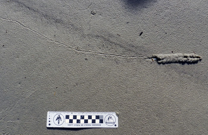
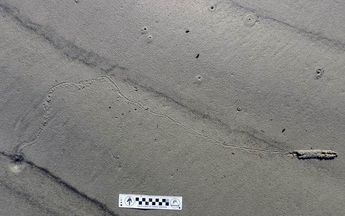
Ghost-Shrimp-Burrow-Tracks-JekyllWhat’s this? We’re looking down on the surface of a Georgia beach at low tide. The collapsed top of a ghost shrimp burrow is in the lower left, but it’s connected to a trackway, which ends in a shallow horizontal burrow, which holds the maker of all three types of traces. Lots of other ghost-shrimp burrow tops are in the upper part of the photo, too. Life doesn’t get much better than this for an ichnologist. You may now envy me. (Photo by Anthony Martin, taken on Jekyll Island, Georgia; scale in centimeters. )

Why ghost shrimp? Because they can burrow like nobody’s business. Take a typical ghost shrimp in the Bahamas or the Caribbean, such as Glypterus acanthochirus. This crustacean is only about 10-cm (4-in) long, but if it lives for eight years and burrows continuously through that time, it will have processed a cubic meter of sediment. Individual ghost-shrimp burrows can go as deep as 5 m (16 ft). These would be like a human shoveling more than a cubic kilometer of dirt, or a vertical shaft about 100 m (330 ft) deep, but without a shovel, backhoes, augers, drilling rigs, or other tools. These vertical shafts then connect with extensive branching tunnels, making complicated networks in the sand and mud below the level of the low tide. Now multiply that industriousness by millions, and we’re talking about enormous volumes of sediment processed by ghost shrimp in their respective shallow-water environments. Ghost shrimp are like the ants of the ocean, only not as organized: no queens, workers, soldiers, or other divisions of labor, just lots of individual shrimp burrowing, eating, mating, and defecating.

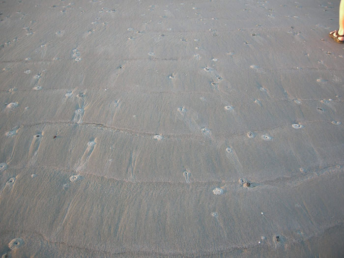
Ghost-Shrimp-Burrow-TopsEvery one of these holes is the top of an occupied ghost-shrimp burrow. Now imagine meters-long vertical shafts from each of these going down into the beach sand, then turning into branching horizontal networks of such grandeur, they would further embarrass naked moles rats, which are already apologizing for how they look. (Photo by Anthony Martin, taken on Sapelo Island, Georgia. Human foot (upper right), still attached to human, for scale.)

Ghost shrimp share a common ancestor with crabs, lobsters, crayfish, and shrimp, all of these having four pairs of walking legs and one pair of claws. (Mantis shrimp are actually not true shrimp – or even decapods – but stomatopods.) Ghost shrimp are also known by marine biologists and ichnologists as callianassid shrimp, belonging to an evolutionarily linked group (clade), Callianassidae.They burrow through sand and mud using their front two claws, but also carry sediment on their other legs. Ghost shrimp are also well-known for depositing much of the mud on Georgia beaches as elegantly packaged little cylindrical fecal pellets. These bear enough of a resemblance to “chocolate sprinkles” on cupcakes that they become tempting to sample, until you remember that they’re, like, you know, fecal.

Ghost-Shrimp-Fecal-PelletsGhost-shrimp fecal pellets, each about 5 mm long, and recently ejected by a ghost shrimp through the top of the burrow, which is the little hole just to the right. If you use them with any cupcake recipes, let me know how that worked for you. (Photo taken by Anthony Martin on St. Catherines Island, Georgia.)
Geologists love ghost shrimp, too, because of how their burrows are so numerous, fossilize easily, and are sensitive shoreline indicators. I wrote about this before with regard to how geologists in the 1960s were able to map ancient barrier islands of the Georgia coastal plain by looking for trace fossils of these burrows. Since then, geologists and paleontologists have identified and applied these sorts of trace fossils worldwide, and in rocks from the Permian Period to the Pleistocene Epoch.

I could prattle on about ghost shrimp and their ichnological incredibleness for the rest of the year, but will spare you of that, gentle reader, and instead will get to the point of this post. Just when I thought I’d learned nearly everything I needed to know about ghost-shrimp ichnology, one shrimp decided I needed to have my eyes opened to some traces I had never seen them make before just a few months ago. I mentioned these traces briefly in a previous blog post, when I was teaching undergraduate students from my barrier-islands class on Jekyll Island (Georgia) in mid-March. They were tracks and a shallow horizontal burrow made on the surface on the northernmost beach of Jekyll Island, and they were made by a ghost shrimp. How do I know they were made by a ghost shrimp? Well, maybe because they had a ghost shrimp attached to them, but that’s beside the point.

Ghost-Shrimp-Tracks-Burrow-Left-JekyllA close-up of the left side of the trackway shows more clearly how it definitely is connected to the funneled top of a burrow. The trackway shows small pointed impressions and a central groove in places, showing that this is an animal with legs and a tail, respectively. The irregular path of the trackway is a record of pauses, where the trackmaker stopped briefly before moving on. The body length of the tracemaker is subtly revealed along the way too, but explaining that would require a more advanced lesson in ichnology. So maybe another time. (Photo by Anthony Martin, taken on Jekyll Island, Georgia.)
Ghost-Shrimp-Tracks-Burrow-Right-JekyllThe right side of the trackway, ending in a short and shallow horizontal tunnel, just under the sandy beach surface. (Photo by Anthony Martin, taken on Jekyll Island, Georgia.)
Ghost-Shrimp-Tracks-Burrow-Closeup-JekyllThe trackway and tail-trail ends in a tunnel with a thin roof of sand. The bilobed pattern was made by the claws and other legs on either side moving sand up and around the body of the tracemaker. Notice the roof collapsed a little on the right, and that its tail is sticking out on the left: kind of like hiding under a too-short blanket. (Photo by Anthony Martin, taken on Jekyll Island, Georgia.)

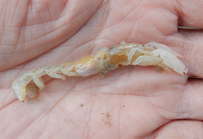
Ghost-Shrimp-JekyllTa-da – the tracemaker revealed! I’m fairly sure this is a Georgia ghost shrimp (Biffarius biformis), but would appreciate all of those marine biologists out there to correct me if I’m wrong. (And not those fake marine biologists, either.) Rest assured, after showing it to my students and allowing them to photograph it, I put it back in the ocean, where it burrowed happily ever after. Unless it died, that is. (Photo by Anthony Martin, taken on Jekyll Island, Georgia.)
What truly amazed me about these traces, though, was their rarity. As I shared with my students, in more than 15 years of field work on the Georgia coast, I had never seen anything like this sequence of traces. Even better, the tracemaker was right there, and like the period at the end of a sentence in the story.

Furthermore, the story told by these traces was that something must have threatened the life of this shrimp to cause it to behave in such an unusual way. These shrimp almost never see the light of day, and prefer to stay deep in their burrows, away from the prying eyes and beaks of shorebirds, fish, and other predators. Consequently, they remain largely invisible to humans; hence the “ghost” part of their nickname. This means something very bad must have happened to this one in its burrow, prompting it to abandon its refuge and expose itself so vulnerably. It would be like a fire forcing people out of their fortified underground bunkers, but when they know tyrannosaurs are lurking just outside. Damned if you do, damned if you don’t, but something in this ghost shrimp’s evolutionary program made it take the path of the lesser damned.

What happened? Did a predator find its way into the burrow and chase it out? Was it a chemical cue of some sort, like oxygen-poor water flooding into the bottom of its burrow? Was it competition from another ghost shrimp, evicting it from its home? Was it a mate that decided it had enough of sharing this burrow and needed some “alone time,” or took up with another more comely shrimp? I don’t know, but it made for a good little mystery, yet another posed by life traces on a Georgia beach, and one I was delighted to discover and share with my students on Jekyll Island.

Teaching on an Old Friend, Sapelo Island

(This post is the fourth in a series about a spring-break field trip taken last week with my Barrier Islands class, which I teach in the Department of Environmental Studies at Emory University. The first three posts, in chronological order, tell about our visits to Cumberland Island, Jekyll Island, and Little St. Simons and St. Simons Islands. For the sake of conveying a sense of being in the field with the students, these posts mostly follow the format of a little bit of prose – mostly captions – and a lot of photos.)
When planning a week-long trip to the Georgia barrier islands with my students, I knew that one island – Sapelo – had to be included in our itinerary. Part of my determination for us to visit it was emotionally motivated, as Sapelo was my first barrier island, and you always remember your first. But Sapelo has much else to offer, and because of these many opportunities, it is my favorite as an destination for teaching students about the Georgia coast and its place in the history of science.

Getting to Sapelo Island requires a 15-minute ferry ride, all for the low-low price of $2.50. (It used to cost $1.00 and took 30 minutes. My, how times have changed.) For my students, their enthusiasm about visiting their fourth Georgia barrier island was clearly evident (with perhaps a few visible exceptions), although photobombing may count as a form of enthusiasm, too.
I first left my own traces on Sapelo in 1988 on a class field trip, when I was a graduate student in geology at the University of Georgia. My strongest memory from that trip was witnessing alligator predation of a cocker spaniel in one of the freshwater ponds there. (I suppose that’s another story for another day.) Yet I also recall Sapelo as a fine place to see geology and ecology intertwining, blending, and otherwise becoming indistinguishable from one another. This impression will likely last for the rest of my life, reinforced by subsequent visits to the island. This learning has always been enhanced whenever I’ve brought my own students there, which I have done nearly every year since 1997.

As a result of both teaching and research forays, I’ve spent more time on Sapelo than all of the other Georgia barrier islands combined. Moreover, it is not just my personal history that is pertinent, but also how Sapelo is the unofficial “birthplace” of modern ecology and neoichnology in North America. Lastly, Sapelo inspired most of the field stories I tell at the start of each chapter in my book, Life Traces of the Georgia Coast. In short, Sapelo Island has been very, very good to me, and continues to give back something new every time I return to it.

So with all of that said, here’s to another learning experience on Sapelo with a new batch of students, even though it was only for a day, before moving on to the next island, St. Catherines.

(All photographs by Anthony Martin and taken on Sapelo Island.)

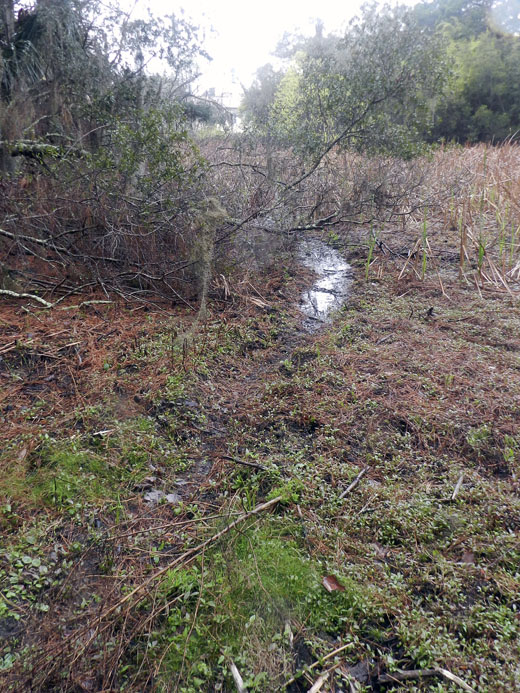
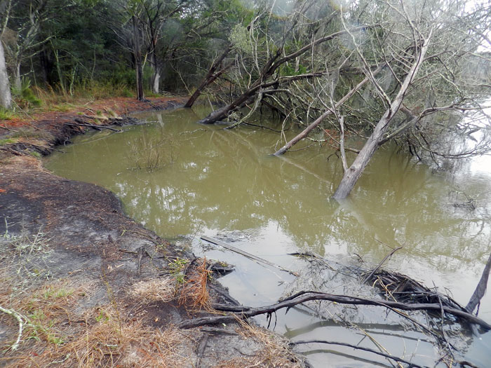
Next to the University of Georgia Marine Institute is a freshwater wetland, a remnant of an artificial pond created by original landowner R.J. Reynolds, Jr. More importantly, this habitat has been used and modified by alligators for at least as long as the pond has been around. For example, this trail winding through the wetland is almost assuredly made through habitual use by alligators, and not mammals like raccoons and deer, because, you know, alligators.

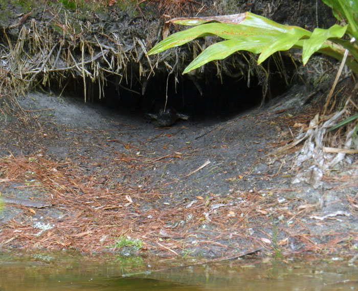
Photographic evidence that alligators, much like humans prone to wearing clown shoes, will use dens that are far too big for them. This den was along the edge of the ponded area of the wetland, and has been used by generations of alligators, which I have been seeing use it on-and-off since 1988.

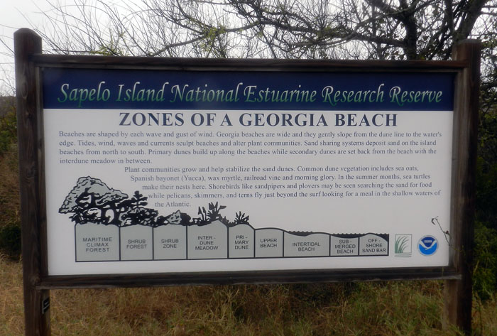
An idealized diagram of ecological zones on Sapelo Island, from maritime forest to the subtidal. This sign provided a good field test for my students, as they had already (supposedly) learned about these zones in class, but now could experience the real things for themselves. And yes, this will be on the exam.

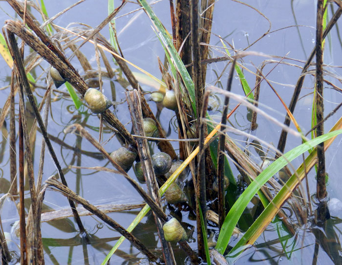
When it’s high tide in the salt marsh, marsh periwinkles (Littoraria irrorata) seek higher ground, er, leaves, to avoid predation by crabs, fish, and diamondback terrapins lurking in the water. Here they are on smooth cordgrass (Spartina alterniflora), and while there are getting in a meal by grazing on algae on the leaves.

Erosion of a tidal creek bank caused salt cedars (which are actually junipers, Juniperus virginiana) to go for their first and last swim. I have watched this tidal creek migrate through the years, another reminder that even the interiors of barrier islands are always undergoing dynamic change.

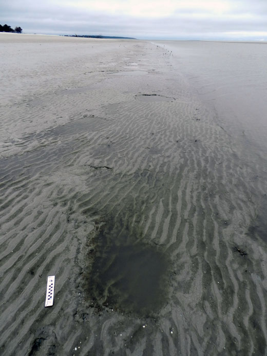
OK, I know what you’re thinking: where’s the ichnology? OK, how about these wide, shallow holes exposed in the sandflat at low tide? However tempted you might be to say “sauropod tracks,” these are more likely fish feeding traces, specifically of southern stingrays. Stingrays make these holes by shooting jets of water into the sand, which loosens it and reveals all of the yummy invertebrates that were hiding there, followed by the stingray chowing down. Notice that some wave ripples formed in the bottom of this structure, showing how this stingray fed here at high tide, before waves started affecting the bottom in a significant way.

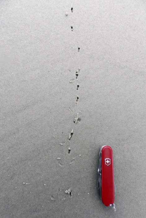
Here’s more ichnology for you, and even better, traces of shorebirds! I am fairly sure these are the double-probe beak marks of a least sandpiper, which may be backed up by the tracks associated with these (traveling from bottom to top of the photo). But I could be wrong, which has happened once or twice before. If so, an alternative tracemaker would be a sanderling, which also makes tracks similar in size and shape to a sandpiper, although they tend to probe a lot more in one place.

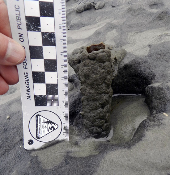
Just in case you can’t get enough ichnology, here’s the lower, eroded shaft of a ghost-shrimp burrow. Check out that burrow wall, reinforced by pellets. Nice fossilization potential, eh? This was a great example to show my students how trace fossils of these can be used as tools for showing where a shoreline was located in the geologic past. And sure enough, these trace fossils were used to identify ancient barrier islands on the Georgia coastal plain.

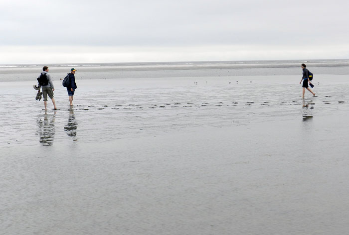
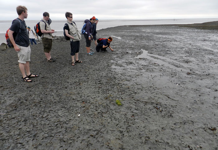
Understandably, my students got tired of living vicariously through various invertebrate and vertebrate tracemakers of Sapelo, and instead became their own tracemakers. Here they decided to more directly experience the intertidal sands and muds of Cabretta Beach at low tide by ambulating through them. Will their tracks make it into the fossil record? Hard to say, but I’ll bet the memories of their making them will last longer than any given class we’ve had indoors and on the Emory campus. (No offense to those other classes, but I mean, you’re competing with a beach.)

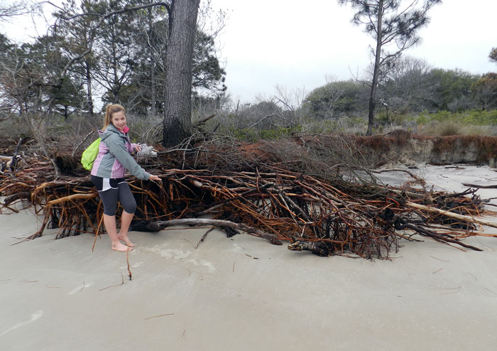
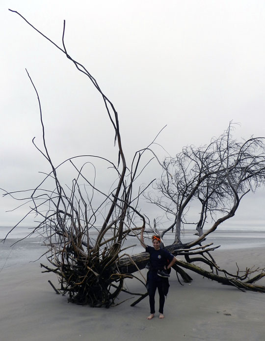
The north end of Cabretta Beach on Sapelo is eroding while other parts of the shoreline are building, and nothing screams “erosion!” as loudly as dead trees from a former maritime forest with their roots exposed on a beach. Also, from an ichnological perspective, the complex horizontal and vertical components of the roots on this dead pine tree could be compared to trace fossils from 40,000 year-old (Pleistocene) deposits on the island. Also note that at this point in the trip, my students had not yet tired of being “scale” in my photographs, which was a good thing for all.

Another student eager about being scale in this view of a live-oak tree root system. See how this tree is dominated by horizontal roots? Now think about how trace fossils made by its roots will differ from those of a pine tree. But don’t think about it too long, because there are a few more photos for you to check out.

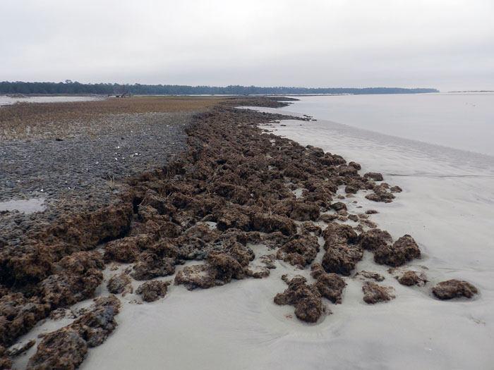
Told you so! Here’s a beautifully exposed, 500-year-old relict marsh, formerly buried but now eroding out of the beach. I’ve written about this marsh deposit and its educational value before, so will refrain from covering that ground again. Just go to this link to learn about that.

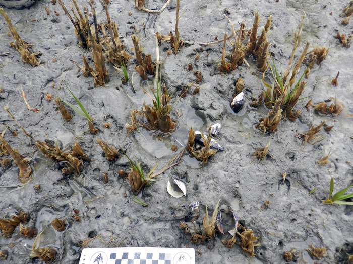
OK geologists, here’s a puzzler for you. The surface of this 500-year-old relict marsh, with its stubs of long-dead smooth cordgrass and in-place ribbed mussels (Guekensia demissa), also has very-much-live smooth cordgrass living in it and sending its roots down into that old mud. So if you found a mudstone with mussel shells and root traces in it, would you be able to tell the plants were from two generations and separated by 500 years? Yes, I know, arriving at an answer may require more beer.

Although a little tough to see in this photo, my students and I, for the first time since I have gone to this relict marsh, were able to discern the division between the low marsh (right) and high marsh (left). Look for the white dots, which are old ribbed mussels, which live mostly in the high marsh, and not in the low marsh. Grain sizes and burrows were different on each part, too: the high marsh was sandier and had what looked like sand-fiddler crab burrows, whereas the low marsh was muddier and had mud-fiddler burrows. SCIENCE!

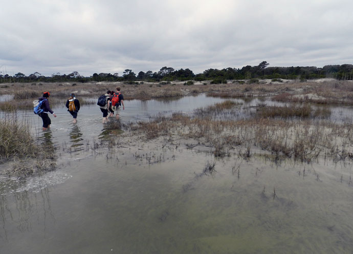
At the end of a great day in the field on Sapelo, it was time to do whatever was necessary to get back to our field vehicle, including (gasp!) getting wet. The back-dune meadows, which had been inundated by unusually high tides, presented a high risk that we might experience a temporary non-dry state for our phalanges, tarsals, and metatarsals. Fortunately, my students bravely waded through the water anyway, and sure enough, their feet eventually dried. I was so proud.

So what was our next-to-last stop on this grand ichnologically tainted tour of the Georgia barrier islands? St. Catherines Island, which is just to the north of Sapelo. Would it reveal some secrets to students and educators alike? Would it have some previously unknown traces, awaiting our discovery and description? Would any of our time there also involve close encounters with large reptilian tracemakers? Signs point to yes. Thanks for reading, and look for that next post soon.


Trace Evidence for New Book

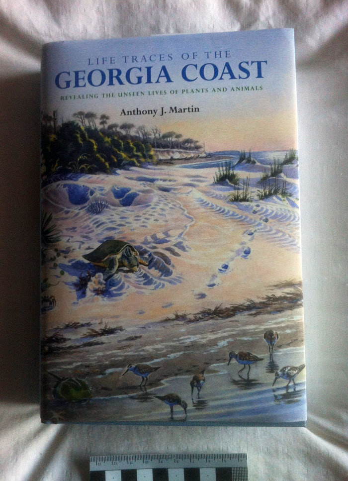
This past Friday, I very happily received the first complimentary copy of my new book, Life Traces of the Georgia Coast from Indiana University Press. After years of field observations, photographing, writing, editing, drawing, teaching, and speaking about the plant and animal traces described in this book, it was immensely satisfying to hold a physical copy in my hands, feeling its heft and admiring its textures and smells in a way that e-books will never replace. So for any doubters out there (and I don’t blame you for that), here is a photograph of the book:

A photograph, purportedly documenting the publication of at least one copy of my new book Life Traces of the Georgia Coast. Photo scale (bottom) in centimeters.

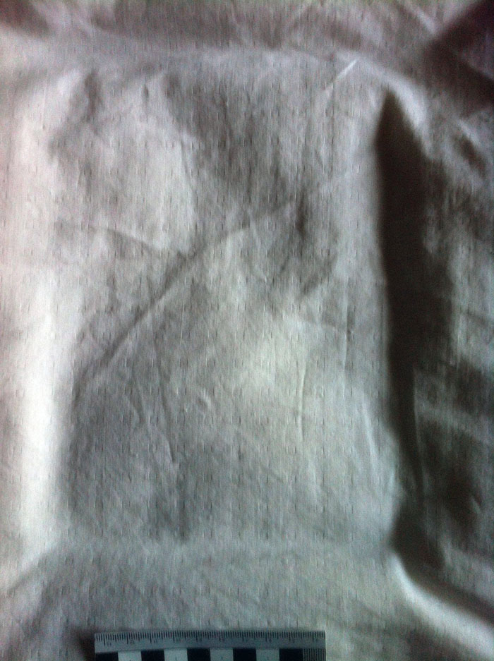
Still, given that a photograph of the book only constitutes one line of evidence supporting its existence, I knew that more data were needed. So of course, I turned to ichnology for help. After all, a 692-page hard-cover book should also make an easily definable resting trace. Here is that trace, formed by the book in the same spot shown previously.

Ichnological evidence supporting the existence of my new book, Life Traces of the Georgia Coast. Using the “holy trinity” of ichnology – substrate, anatomy, and behavior – as guides for understanding it better: the substrate is a bedspread; the “anatomy” is the 6 X 9″ outline of the book, with depth of the trace reflecting its thickness (and mass); and the behavior was mine, consisting of placing the book on the bedspread and removing it. E-book versions of the book should make similarly shaped rectangular traces, although these will vary in dimensions according to the reading device hosting the book.

However, I also admit that hard-core skeptics may claim that such photos could have been faked, whether through the manipulative use of image-processing software, or slipping the cover jacket onto a copy of Danielle Steel’s latest oeuvre. As a result, the best and perhaps only way to test such a hypothesis is for you and everyone you know to buy the book (which you can do here, here, or here). Or, better yet, ask your your local bookstore to carry copies of it, which will also help to ensure the continuing existence of those bookstores for future book-purchasing and ichnological experiments, including books of other science-book authors.

Lastly, just to make this experiment statistically significant, I suggest a sample size of at least n = 10,000, which should account for inadvertent mishaps that may prevent deliveries of the book, such as lightning strikes, volcanic eruptions, or meteorite impacts. Only then will you be able to assess, with any degree of certainty, whether the book is real or not.

Thank you in advance for your “citizen science,” and I look forward to discussing these research results with you soon.

Suggested Further Reading

Martin, A.J. 2012. Life Traces of the Georgia Coast: Revealing the Unseen Lives of Plants and Animals. Indiana University Press, Bloomington, Indiana: 692 p.


A Sneak Peek at a Book Jacket (with Traces)

After returning from a two-week vacation in California with my wife Ruth, we noticed a cardboard tube awaiting us at home. Intriguingly, the mystery package, which was only about 60 cm (24 in) long and 8 cm (3 in) wide, had been sent by Indiana University Press, the publisher of my new book, Life Traces of the Georgia Coast. We were a little puzzled by it, considering that it couldn’t possibly contain complimentary copies of the book. (As of this writing, I still have not held a corporeal representation of the book, hence my continuing skepticism that it is really published.) What was in this mystery tube?

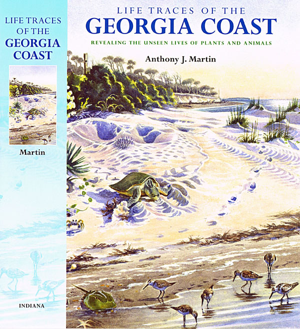
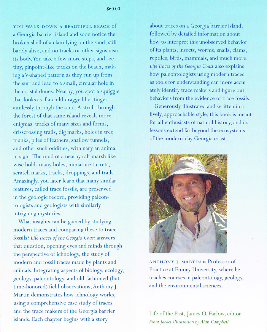
Front cover and spine of my new book, Life Traces of the Georgia Coast: Revealing the Unseen Lives of Plants and Animals (Indiana University Press). The book, newly released this month, is not yet in stores, but supposedly on its way to those places and to people who were kind enough to pre-order it. But if you didn’t pre-order it, that’s OK: you can get it right here, right now.

Upon opening it, we were delighted to find that it held ten life-sized prints of the book jacket: front cover, spine, back cover, and front-back inside flaps. The cover art, done by Georgia artist Alan Campbell, looked gorgeous, and had reduced well to the 16 X 25 cm (6 X 9″) format, retaining details of traces and tracemakers, but also conveying a nice aesthetic sense. I was also amused to see the spine had the title (of course) but also said “Martin” and “Indiana.” Although I’ve lived in Georgia for more than 27 years, I was born and raised in Indiana, so it somehow seemed fitting in a circle-of-life sort of way to see this put so simply on the book.

Back cover of Life Traces of the Georgia Coast, highlighting a few of the tracemakers mentioned in the book – sea oats, sandhill crane, sand fiddler crab, and sea star – while also providing a pretty sunset view of primary dunes, beach, and subtidal environments on Sapelo Island. (P.S. I love that it says “Science” and “Nature” at the top, too.)

I had no idea what the back cover might be like until seeing these prints, but I thought it was well designed, bearing a fair representative sample of tracemakers of the Georgia barrier islands: sea oats (Uniola paniculata), a sandhill crane (Grus canadensis), sand fiddler crab (Uca pugilator), and lined sea star (Luidia clathrata), as well as a scenic view of some coastal environments. I had taken all of these photos, so it was exciting to see these arranged in such a pleasing way. My only scientifically based objection is that I would have like to see it include photos of insects, worms, amphibians, reptiles, or mammals (these and much more are covered in the book), as well as a few more tracks, trails, or burrows. Granted, I suppose they only had so much room for that 6 X 9″ space, and thus I understood how they couldn’t use this space to better represent the biodiversity of Georgia-coast tracemakers and their traces. (Oh well: guess you’ll have to read the book to learn about all that.)

Inside front and back flap material for Life Traces of the Georgia Coast, which also includes a summary of the book (written by me) and a rare photo of me (taken by Ruth Schowalter) in my natural habitat, which in this instance was on St. Catherines Island, Georgia.

I had written the summary of the book on the inside flap nearly a year ago, so it was fun to look at it with fresh eyes, almost as if someone else had written it for me. Fortunately, I banished my inner critic while reading it, and just enjoyed the sense that it likely achieved its goal, which was to tell people about the book and provoke their interest in it.

In short, this cover jacket symbolizes a next-to-last step toward the book being real in my mind. Now, like any good scientist, all I need is some independently verifiable evidence in the form of tactile data, such as a physical book in my hands. Stay tuned for that update, which I’ll be sure to share once it happens. In the meantime, many thanks to all of the staff at Indiana University Press – who I’ll mention by name next time – for their essential role in making the book happen and promoting it in this new year.

Information about the Book, from Indiana University Press

Life Traces of the Georgia Coast: Revealing the Unseen Lives of Plants and Animals, Anthony J. Martin

Have you ever wondered what left behind those prints and tracks on the seashore, or what made those marks or dug those holes in the dunes? Life Traces of the Georgia Coast is an up-close look at these traces of life and the animals and plants that made them. It tells about the how the tracemakers lived and how they interacted with their environments. This is a book about ichnology (the study of such traces), a wonderful way to learn about the behavior of organisms, living and long extinct. Life Traces presents an overview of the traces left by modern animals and plants in this biologically rich region; shows how life traces relate to the environments, natural history, and behaviors of their tracemakers; and applies that knowledge toward a better understanding of the fossilized traces that ancient life left in the geologic record. Augmented by numerous illustrations of traces made by both ancient and modern organisms, the book shows how ancient trace fossils directly relate to modern traces and tracemakers, among them, insects, grasses, crabs, shorebirds, alligators, and sea turtles. The result is an aesthetically appealing and scientifically accurate book that will serve as both a source book for scientists and for anyone interested in the natural history of the Georgia coast.

Life of the Past – Science/Paleontology

692 pp., 34 color illus., 137 b&w illus.
cloth 978-0-253-00602-8 $60.00
ebook 978-0-253-00609-7 $51.99

More information at:

http://www.iupress.indiana.edu/catalog/806767 ]http://www.iupress.indiana.edu/catalog/806767