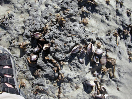
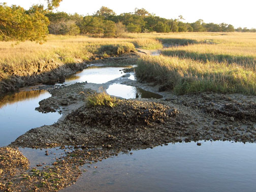
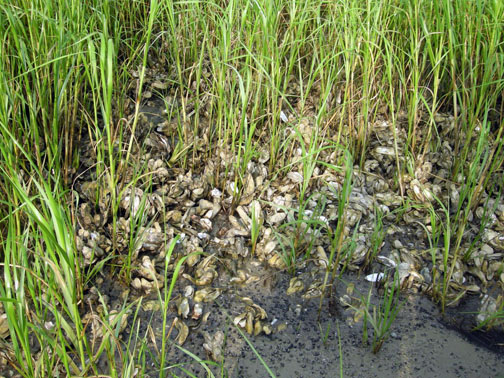
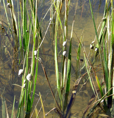
On the 3rd Day of Ichnology, My Island Gave to Me: 3 Ghost Shrimp Pooping

Everyone poops. More specifically, every animal has to eat, converting this food into energy and otherwise applying it to bodily functions. As we also know through daily experience, this conversion is never 100% efficient. Thus waste is produced and excreted from all animal bodies, sometimes liquid, sometimes solid, or a mixture of the two.

And on the Georgia barrier islands, few animals are more visibly productive with their poop than ghost shrimp. So today’s photo and explanation celebrates those wondrous poopers of the Georgia coast.

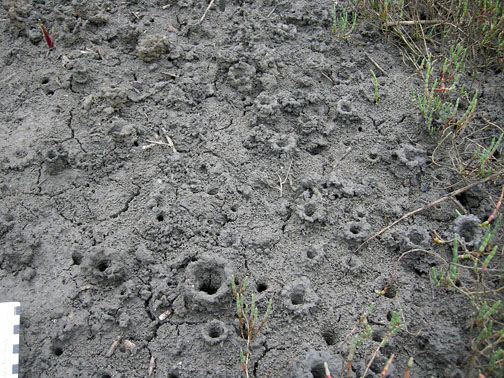
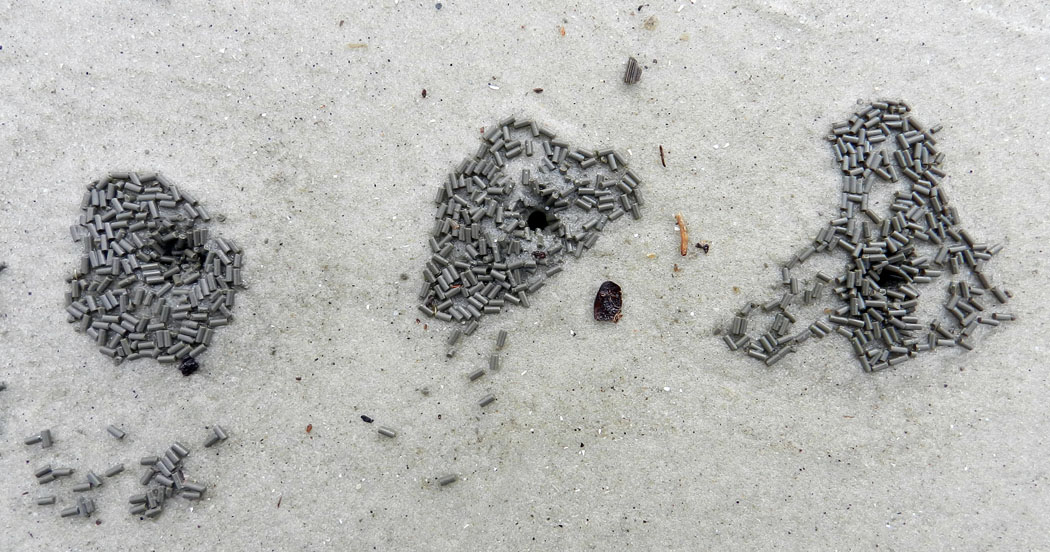
Ghost-Shrimp-Pellets-Burrows-JekyllWe three burrows of Georgia coast are adorned with feces, showing that each of us is actively occupied by a ghost shrimp. In each burrow, the shrimp is probably just below the narrow aperture, doing a little housecleaning. (Photograph by Anthony Martin, taken on Jekyll Island, Georgia.)

I’ve written previously about ghost shrimp – otherwise known as callianassid shrimp – and the significance of their burrows to ecologists, geologists, and  paleontologists (linked under “Further Reading”). But I haven’t focused on one of their most important roles as ecosystem engineers, which is their prolific pooping of pellets.

These pellets are small, dark, perfectly shaped cylinders that, because of their resemblance to “chocolate sprinkles,” never fail to capture the attention of cupcake lovers as they stroll along Georgia beaches. (Now that you know what they are, please don’t eat them. Unless you like them, in which case, I’m never buying a cupcake from you.) However, aside from inspiring confectionery allusions, these pellets are extremely important in Georgia beach environments as sources of mud.

Only two species of ghost shrimp are responsible for all of this mud dumping, the Georgia ghost shrimp (Biffarius biformis) and Carolina ghost shrimp (Callichirus major). Nonetheless, they make up for their lack of diversity through sheer numbers; look closely at most Georgia beaches at low tide and you will see thousands of little “sand volcanoes,” most with pellets. Nearly all of these represent a live ghost shrimp, down below your feet, burrowing, feeding, mating, and pooping.

After feeding on mud-rich organics in their burrows, these shrimp make and emit mud-rich fecal pellets, neatly shrink-wrapped by mucus. The shrimp can then collect these packets of poop and pump them out the tops of their burrows, an efficient form of waste disposal that keeps their homes clean. These pellets become the hydrodynamic equivalent of sand grains, rolling with the tides and waves and are commonly deposited in ripple troughs and other low spots on a sandy beach.

Eventually their mucus coverings break down and release the mud particles (silt and clay), but at least these sediments were deposited. This would almost never happen on its own because of tides and waves keeping it suspended in the water, and means that the mud would be much less likely to get recycled into coastal sediments, and Georgia coastal waters would be even muddier than normal.

So take note, geologists: those thin layers of mudstone you see in the troughs of a rippled sandstone that you might just label “flaser bedding” in your field notebook, then promptly forget? Those beds probably got there by something pooping in the ancient past. And for everyone else, give thanks for these gift-wrapped feces, and for what they do for Georgia coastal environments.

Further Reading

The Lost Barrier Islands of Georgia. Written by me, posted October 3, 2011.

Ghost Shrimp Whisperer. Written by me, posted May 20, 2013.

Links to Previous Posts in This Theme

On the 12th Day of Ichnology, My Island Gave to Me: 12 Snails Grazing

On the 11th Day of Ichnology, My Island Gave to Me: 11 Plovers Probing

On the 10th Day of Ichnology, My Island Gave to Me: 10 Beetles Boring

On the 9th Day of Ichnology, My Island Gave to Me: 9 Molluscans Hiding

On the 8th Day of Ichnology, My Island Gave to Me: 8 Crab Legs Walking

On the 7th Day of Ichnology, My Island Gave to Me: 7 Lizards Looping

On the 6th Day of Ichnology, My Island Gave to Me: 6 Hatchlings Crawling

On the 5th Day of Ichnology, My Island Gave to Me: 5 Bivalves Drilling

On the 4th Day of Ichnology, My Island Gave to Me: 4 ‘Gators Denning

Tracking Wild Turkeys on the Georgia Coast

Of the many traditions associated with the celebration of Thanksgiving in the U.S., the most commonly mentioned one is the ritual consumption of an avian theropod, Meleagris gallopavo, simply known by most people as “turkey.” The majority of turkeys that people will eat this Thursday, and for much of the week afterwards, are domestically raised. Yet these birds are all descended from wild turkeys native to North America. This is in contrast to chickens (Gallus gallus), which are descended from an Asian species, and various European mammals, such as cattle, pigs, sheep, and goats (Bos taurus, Sus scrofa, Ovis aries, and Capra aegagrus, respectively).

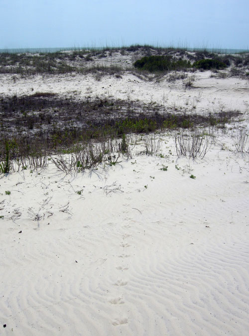
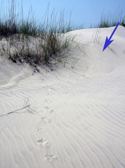
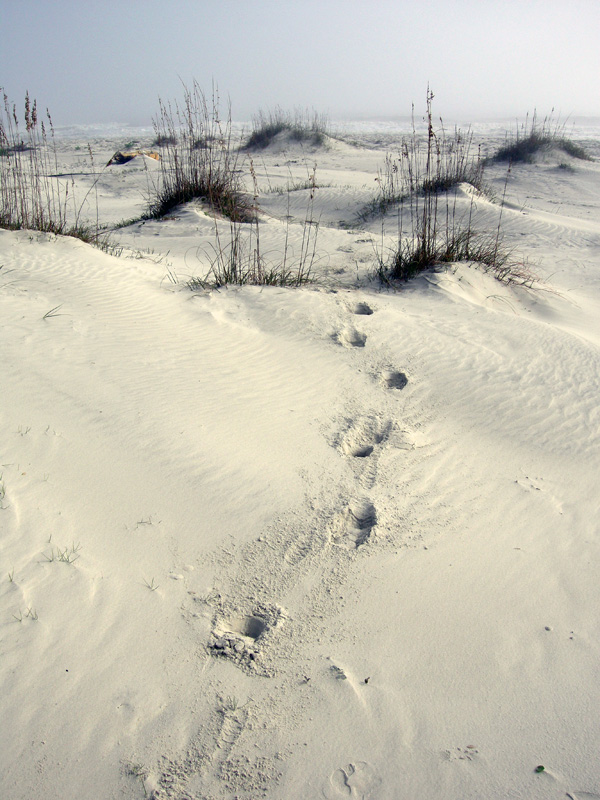
Trackway of a wild turkey (Meleagris gallopavo) crossing a coastal dune on Cumberland Island, Georgia. Notice how this one, which was likely a big male (“tom”), was meandering between clumps of vegetation and staying in slightly lower areas, its behavior influenced by the landscape. Scale = 20 cm (8 in). (Photograph by Anthony Martin.)

American schoolchildren are also sometimes taught that one of the founding fathers of the United States, Benjamin Franklin, even suggested that the wild turkey should be elevated to the status of the national bird, in favor of the bald eagle (Haliaeetus leucocephalus). With an admiring (although I suspect somewhat facetious) tone, he said:

He [the turkey] is besides, though a little vain & silly, a Bird of Courage, and would not hesitate to attack a Grenadier of the British Guards who should presume to invade his Farm Yard with a red Coat on.”

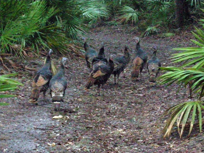
There are eight of us, and only one of you. Do you really want to mess with us? (Photograph by Anthony Martin, taken on Cumberland Island, Georgia.)

Unfortunately, because I live in the metropolitan Atlanta area, I never see turkeys other than the dead packaged ones in grocery stores. Nonetheless, one of the ways I experience turkeys as wild, living animals is to visit the Georgia barrier islands, and the best way for me to learn about wild turkey behavior is to track them. This is also great fun for me as a paleontologist, as their tracks remind me of those made by small theropod dinosaurs from the Mesozoic Era. And of course, as most schoolchildren can tell you, birds are dinosaurs, which they will state much more confidently than anything they might know about Benjamin Franklin.

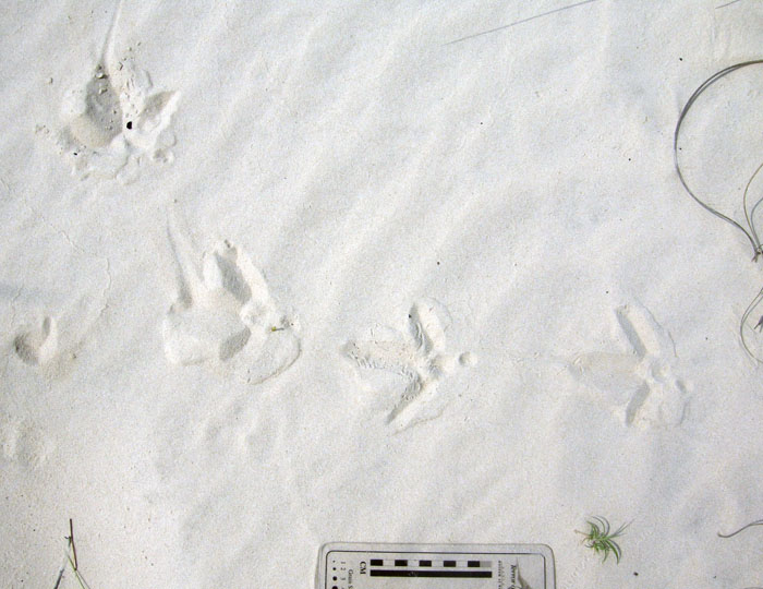
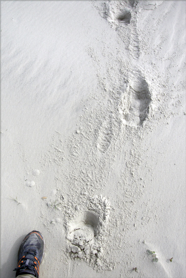
Compared to most birds, turkeys are relatively easy to track. Their footprints are about 9.5-13 cm (3.7-5 in) long and slightly wider than long, with three long but thick, padded toes in front and one shorter one in the back, pointing rearward. In between these digits is a roundish impression, imparted by a metatarsal. This is a trait of an incumbent foot, in which a metatarsal registers behind digit III because the rear part of that toe is raised off the ground. The short toe is digit I, equivalent to our big toe, but not so big in this bird. Despite the reduction of this toe, its presence shows that turkeys probably descended from tree-dwelling species, as this toe was used for grasping branches. Clawmarks normally show on the ends of each toe impression, and when a turkey is walking slowly, it drags the claw on its middle toe (digit III), thus making a nicely defined linear groove.

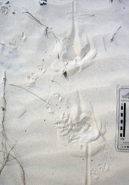
Wild turkey tracks made while it was walking slowly up a gentle dune slope, dragging the claw on the middle digit of its right foot, making a long groove. Also notice the bounding tracks of a southern toad (traveling lower right –> upper left), cross-cutting the turkey tracks. (Photograph by Anthony Martin, taken on Cumberland Island.)

A normal walking pace (right foot –> left foot, left foot –> right foot) for a turkey is anywhere from 15-40 cm (6-16 in), and its stride (right foot –> right foot, left foot –> left foot) is about twice that, or 30-80 cm (12-32 in), depending on the age and size of the turkey. Their trackways show surprisingly narrow straddles for such wide-bodied birds, only 1.5 times more than track widths. This is because they walk almost as if on a tightrope, with angles between each step approaching 180°; so they still make a diagonal pattern, but nearly define a straight line. However, turkeys meander, stop, or change direction often enough to make things interesting when tracking them. Their flocking behavior also means their tracks commonly overlap with one another or cluster, making it tough to pick out the trackways of individual turkeys. However, in such flocks, the dominant male’s tracks are noticeably larger than those of the females or younger turkeys, so these can be picked out and help with sorting who’s who.

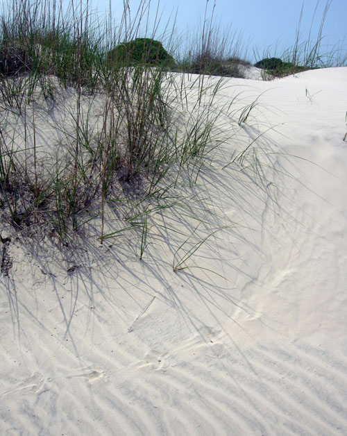
Turkey trackway in which it walked across the wind-rippled surface of a coastal dune on Cumberland Island, meandering while moseying. Same photo scale as before. (Photograph by Anthony Martin.)

An abrupt right turn recorded by a turkey’s tracks. Check out that beautiful metatarsal  impression in the second track from the right, and how the claw dragmark in the thrid track from the right points in the direction of the next track. (Photograph by Anthony Martin.)

One of the more remarkable points about these Georgia barrier-island turkeys, though, is how their tracks belie their stereotyped image as forest-only birds. Although they do spend much of their time in the forest, I’ve tracked turkeys through broad swaths of coastal dunes, and sometimes they will stop just short of primary dunes at the beach. So however difficult it might be to think about these birds as marginal-marine vertebrates, their tracks overlap the same places with ghost-crab burrows and shorebird tracks. Geologists and paleontologists take note: this exemplifies the considerable overlap between terrestrial and marginal-marine tracemakers that can happen in coastal environments. This also happened with dinosaurs that strolled onto tidal flats or otherwise passed through marginal-marine ecosystems.

Turkey tracks heading toward the beach, with the open ocean visible just beyond. Is this close enough to consider turkeys as marginal-marine tracemakers? (Photograph by Anthony Martin.)

Do these turkeys also have an impact on the dunes themselves? Yes, although these effects vary, from trackways disrupting wind ripples to more overt changes to the landscape. For instance, one of the most interesting effects I’ve seen is where they’ve caused small avalanches of sand downslope on dune faces. Interestingly, this same sort of phenomenon was also documented for Early Jurassic dinosaurs that walked across dry sand dunes, which caused grainflows that cascaded downhill with each step onto the sand.

Grainflow structure (arrow), a small avalanche caused by a turkey walking down a dune face. (Photograph by Anthony Martin.)

Close-up of grainflow structure (right) connected to turkey tracks, which become better defined once the turkey reached a more level surface. (Photograph by Anthony Martin, taken on Cumberland Island.)

What other traces do turkeys make? A lot, although I’ve only seen their tracks. Other traces include dust baths, feces, and nests. Dust baths, in which turkeys douse themselves with dry sediment to suffocate skin parasites, must be awesome structures. These are described as 50 cm (20 in) wide, 5-15 (1-3 in) deep, semi-circular depressions, and feather impressions show up in those made in finer-grained sediments. Although such structures would have poor preservation potential in the fossil record, I hold out hope that if paleontologists start looking more at modern examples, they are more likely to find a fossil dust bath, whether in Mesozoic or Cenozoic rocks.

Turkey feces, like most droppings from birds, have white caps on one end, but are unusual in that these can tell you the gender of their depositor. Male turkeys tend to make curled cylinders that are about 1 cm wide and as much as 8 cm long (0.4 X 3 in), whereas females make more globular (not gobbular) droppings that are about 1 cm (0.4 in) wide. These distinctive shapes are a result of their having different digestive systems. Turkeys are herbivores, so their scat normally includes plant material, but don’t be surprised to see insects parts in them, too. Still think about how exciting it would be to find a grouping of same-diameter cylindrical and rounded coprolites in the same Mesozoic deposit, yet filled with the same digested material, hinting at gender differences (sexual dimorphism) in the same species of dinosaur maker.

Turkeys normally make nests on the ground by scratching out slight depressions with their feet, but evidently this is a flexible behavior. On at least one of the Georgia barrier islands (Ossabaw), these birds have been documented as building nests in trees. Although this practice seems very odd for a large, ground-dwelling bird, it is an effective strategy against feral hogs, which tend to eat turkey eggs, as well as eggs of nearly every other species of bird or reptile, for that matter. Just to extend this idea to the geologic past, ground nests are documented for several species of dinosaurs, but tree nests are unknown, let alone whether species of ground-nesting dinosaurs were also capable of nesting in trees.

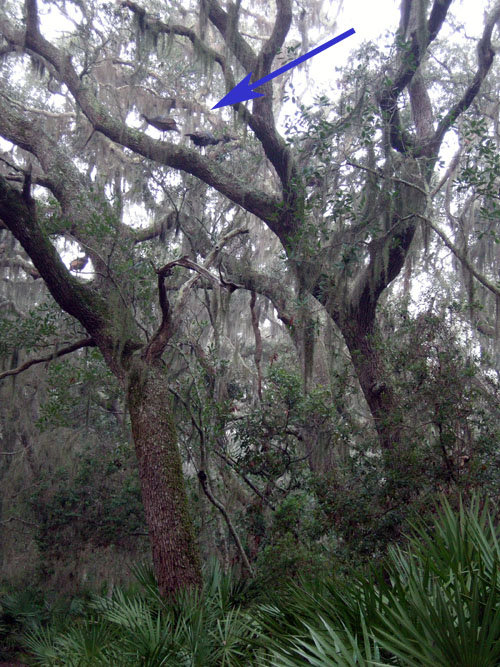
As everyone should know from their favorite WKRP episode, domestic turkeys can’t fly. But wild turkeys can, and use this ability to get into the branches of live oaks (arrow), high above their predators, or even curious ichnologists. (Photograph by Anthony Martin, taken on Cumberland Island.)

So whether or not you have tryptophan-fueled dreams while dozing later this week, keep in mind not just the evolutionary heritage of your dinosaurian meal, but also what their traces tell us about this history. Moreover, it is an understanding aided by these magnificent and behaviorally complex birds on the Georgia barrier islands. For this alone, we should be thankful.

Paleontologist Barbie, tracking wild turkeys on the Georgia coast to learn more about how these tracemakers can be used as modern analogs for dinosaur behavior and traces, and once again demonstrating why she is the honey badger of paleontologists. (Yes, photograph by me, and taken on Cumberland Island. P.S. Happy Thanksgiving!)

Further Reading

Dickson,J.G. (editor). 1992. Wild Turkeys: Biology and Management. Stackpole Books, Mechanicsburg, Pennsylvania: 463 p.

Elbroch, M., and Marks, E. 2001. Bird Tracks and Sign of North America. Stackpole Books, Mechanicsburg, Pennsylvania: 456 p.

Fletcher, W.O., and Parker, W.A. 1994. Tree nesting by wild turkeys on Ossabaw Island, Georgia. The Wilson Bulletin, 106: 562.

Loope, D.B. 2006. Dry-season tracks in dinosaur-triggered grainflows. Palaios, 21: 132-142.

How to Track a Vampire (Bat)

The arrival of Halloween reminds us to celebrate mythical creatures that frighten yet also intrigue us, although recent popular crazes have made this less of an annual event and more year-round. Along those lines, probably the top three of such imaginary beings are zombies, werewolves, and vampires. All of these can be classified as changelings of a sort, with two of them dead, but not really. Here in Georgia, public fascination with zombies has even provided employment opportunities, as many people compete for coveted slots as shuffling extras on the TV series The Walking Dead.

Among these inspirations for Halloween costumes, short stories, novels, musicals, TV shows, and movies, which would be the toughest for an aspiring Van Hesling to track down using ichnological methods? Zombies would be far too easy, considering their slow-moving, foot dragging, bipedal locomotion; their trackways would also commonly intersect as they bump into one another in their search for cranial sustenance. In other words, zombie trackway patterns would closely match those of people texting.

As a result, we have many modern analogs for zombie traces, which would also make their recognition in the fossil record that much easier. Traces made by the zombie-like characters portrayed in 28 Days Later, however, would be far different, showing greater distances between tracks and reflecting more rapid movement. (And all kidding aside, we actually do have trace fossil evidence of zombie ants from about 50 million years ago, an example of reality trumping fiction.)

Similarly, tracking werewolves would be straightforward, in that trackway patterns should show normal human bipedal locomotion followed by abrupt changes to quadrupedal patterns that would range from a trot to full gallop, gaits that are comparatively rare in humans. Anatomical details of tracks would also include a transition from five-toed plantigrade tracks to four-toed digitigrade ones, and metatarsal impressions would be replaced by heel-pad impressions. Additional traces to expect from a werewolf would be the direct effects of successful predation, such as blood spatters, scattering of prey body parts, toothmarks, and so on. (Don’t ask me about werewolf scat, though. I don’t even want to think about some of the things that would show up in that, especially if they started consuming suburbanites.)

Mixed assemblage of wolf and human tracks, which no doubt proves the existence of werewolves. Or not. Your choice. (Photograph by Anthony Martin, taken in Yellowstone National Park, Wyoming: scale = 10 cm (4 in).)

A closer look at those supposed “wolf” tracks. Yes, I know, they’re in the same area of Yellowstone National Park where a successful wolf-release program took place. But my doubt means you have to consider the impossible as equally valid.

A gorgeous “wolf” track with evidence of skidding to a halt and turning to the right. Could this have been made immediately after a human transformed into a wolf? My Magic 8-ball says, “Ask again later.”

Scene from some movie I’ll never see, in which one of the characters undergoes a mid-air transformation from a human to a werewolf (Canis lupus hormonensis), abruptly changing his tracks from a more plantigrade bipedal running to digitigrade quadrupedal movement. Sorry, I don’t know if any evidence of teen angst would preserve in such a trackway, nor do I care.

In contrast to zombies and werewolves, vampires would be the most challenging to track, considering their occasional aerial phases of movement, as depicted in Bram Stoker’s novel Dracula (1897) and various popular adaptations. Traces made during a pre-transformation phase – while still in human form – would be indistinguishable from those of a non-undead human, texting or not, and once in the air, no evidence of its movement would be recorded.

A large bat (megachiropteran) in flight, leaving no traces of its passing when traveling in a substrate of air.

So just to leave vampires for a moment, let’s talk about bats, which are real and do leave traces of their activities. Knowing that bats are among the most diverse and abundant of mammals (more than 1,200 species), I made sure to discuss their traces in my upcoming book, Life Traces of the Georgia Coast. Although I personally have not yet seen any of their traces on the Georgia barrier islands, these are predictable and identifiable, so I hold out hope that I or someone else will find them some day.

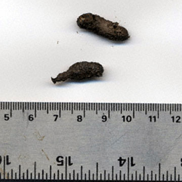
Probably the most likely traces made by bats that one could encounter on the Georgia barrier islands are their feces, which in other places, through the right geology (think caves) and collective action, can form economic resources (more on that later). About 75% of bat species are insectivores, and because they catch their meals on the fly, their scat will mostly contain winged insect parts. However, the geology of the Georgia barrier islands lacks limestone, and thus precludes the formation of caves or other environments serving as roosting spots for bat colonies. Thus bat feces, such as those dropped by the common brown bat (Myotis lucifugus), will be hard to find unless you look in the right place, such as below a favorite roosting spot. If you are lucky enough to notice these, though, these traces are dark 2-3 mm (0.1 in) wide and 5-15 mm (0.2-0.6 in) long cylinders and filled with parts of flying insects.

Two small samples of bat poop for you. You’re welcome. (Image from Internet Center for Wildlife Damage Management.)

Most other bats are fruit-eaters; this means these bats, like many birds, are also important seed dispersers through their excreting indigestible seeds covered in fertilizer. Speaking of fertilizers, massive deposits of bat feces (guano) also accumulate in caves and other places where millions of bats have roosted. These nitrogen- and phosphorous-rich deposits have been mined for fertilizers used in agriculture, an example of feeding traces helping to feed people.

Do bats come to the ground and leave tracks? Yes, once in a while they do, where they might forage and walk on all fours. When they do this, they make diagonal walking patterns, contacting with the thumbs on the tips of their wings – which are skin membranes connected to their other, elongated fingers – and their rear feet.

OK, now back to vampires, or rather, vampire bats. There are only three species of parasitic bats, all of which subsist on the blood of other mammals. For feeding, they slice skin with their sharp teeth, which leaves a small (several centimeters long, millimeters thin) incision. They then lap up whatever blood comes out, and the victim often isn’t aware of its blood loss. These wounds also heal, but leave visible scars.

What about other traces left by vampire bats? Surprisingly, scientists have actually asked themselves, “Hey, I wonder how vampire bats get around on the ground?”, and conducted experiments on terrestrial movement of the common vampire-bat (Desmodus rotundus), as well as the short-tailed bat of New Zealand (Mystacina tuberculata).

Just in case you needed another reason why science is cool, these scientists constructed bat-sized treadmills and placed these bats on them. This experiment confirmed that bats, including the common vampire bat, perform an alternating-walking movement in which the rear foot (pes) registers just behind the thumb, which also bears a claw. (This claw comes in handy as a sort of grappling hook at they climb onto their blood sources.)

Walking on Wings from Science News on Vimeo.

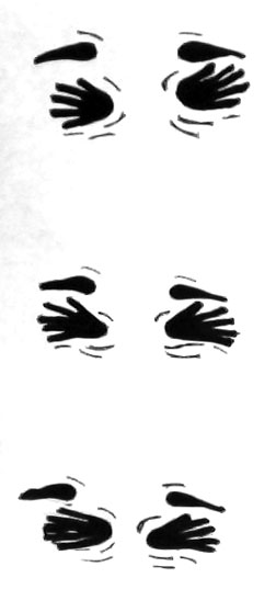
Based on this video, here is what I would hypothesize as the trackway pattern of a walking vampire bat. Note that the rear foot has five digits, nearly equal in length, and that the feet point away from the midline of the trackway.

But then they found out something most people didn’t expect. When they increased treadmill speeds, the bats bound and almost gallop, in which their rear feet nearly move past their wings. While bounding, these bats land on one of the digits on their wings, then push off with their rear feet, causing a suspension phase, reaching maximum speeds of 1.2 m/s. (Which, incidentally, is about the same speed as most people walking while texting, or slow zombies.) The resulting trackway patterns would be in sets of four – rear feet paired behind thumb impressions – separated from one another by about a body length. Based on my viewing of the videos, the trackways would show both half-bound and full-bound patterns, in which the rear feet are either offset or parallel, respectively.

Vampire Running from Science News on Vimeo.

And here is the hypothesized trackway pattern for a running vampire bat, which is almost like a gallop pattern, but more like a half-bound or full-bound. The feet actually should point a little more inward than during walking, and depending on the substrate, deformation structures might be associated with track exteriors.

Just to insert a little paleontology into this consideration of bat traces: has anyone found a trackway, feces, or other traces made by bast in the fossil record? No, unless you count old guano deposits as trace fossils (which I would if they exceed 10,000 years old). The body fossil record for bats extends back to the Eocene Epoch, about 50 million years ago, but such fossils are rare, too. Far more impressive than a bat body fossil, though, would be a fossil bat trackway would be the discovery of a lifetime, almost as noteworthy as finding an actual vampire. And if you found a fossil bat trackway where it was running? Time to start playing the lottery.

More readily available in ancient strata, though, are pterosaur tracks, whose makers likely walked in a manner similar to bats when on land. Hence bats, although not directly related to these flying reptiles, may provide analogues for how some small pterosaurs moved about when on the ground. Despite their long study and many pterosaur fossils, though, a few people are still arguing about how pterosaurs moved on the ground. So hopefully more studies of bat locomotion will help us to better understand the earthbound behaviors of pterosaurs.

The take-home message of the preceding is that even though zombies, werewolves, and vampires still garner plenty of attention from the public, the truth is that real animals of the past and present – like bats and pterosaurs – are actually more fantastic than we sometimes know. Sure, let’s continue to have fun with our mythical creatures, but in the meantime, also keep an eye out for traces left by the marvelous animals of today and yesteryear.

Further Reading

Elbroch, M. 2003. Mammal Tracks and Sign: A Guide to North American Species. Stackpole Books, Mechanicsburg, Pennsylvania: 778 p.

Mazin, J.-M., Billon-Bruyat, J.-P., and Padian, K. 2009. First record of a pterosaur landing trackway. Proceedings of the Royal Society of London, B, 276: 3881-3886.

Padian, K., and Fallon, B. 2012. Meta-analysis of reported pterosaur trackways: testing the corrspondence between skeletal and footprint records. Journal of Vertebrate Paleontology, 32 [Supplement to 3]: 153.

Riskin, D.K. et al. 2006. Terrestrial locomotion of the New Zealand short-tailed bat Mystacina tuberculata and the common vampire bat Desmodus rotundus. Journal of Experimental Biology, 209: 1725-1736.

Traces of Toad Toiletry and Naming Trace Fossils

Sometimes I envy those people on the Georgia barrier islands who, through sheer number of hours in the field, come upon animal traces that I’ve never seen there. But this was one of those instances where the find was so extraordinary that I will suppress my jealous urges, celebrate the person who found it, marvel at it, and share its specialness with others.

Gale Bishop, a fellow ichnologist who is currently on St. Catherines Island, found an intriguing sequence of traces during a morning foray on its dunes and beaches there last week. In his second life – his first was as a geology professor at Georgia Southern University – he has transformed into an indefatigable sea-turtle-nesting monitor on St. Catherines and coordinator of a teacher-training program. Part of his daily routine there, among many other duties, includes looking for mother-turtle traces – trackways and nests – during the nesting season, which in Georgia is from May through September.

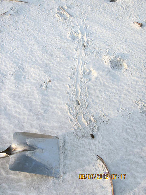
Along the way, with his eyes well trained for spotting jots and tittles in the sand, Gale often notices oddities that likely would be missed by most people, including me. The following photograph, which he shared on the St. Catherines Island Sea Turtle Program page on Facebook, is from a find he made about 7:15 a.m. on Saturday, July 7. Take a look, and please, if you haven’t already, forget the title of this post as you ponder its clues.

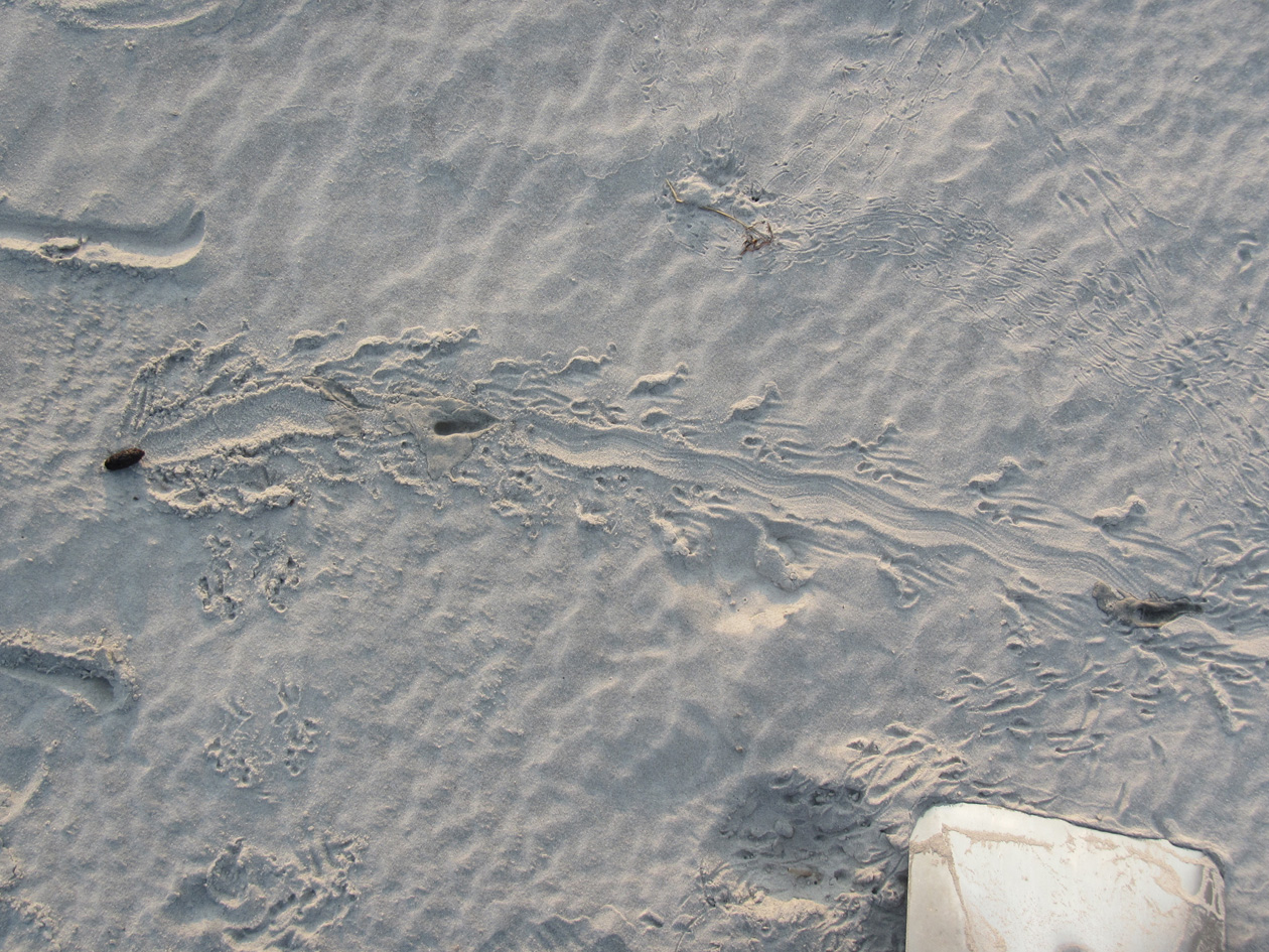
A mystery in the dune sands of St. Catherines Island on the Georgia coast, begging to be interpreted. No, not the shovel: those are never mysterious. Look at the traces to the left and above the shovel. What made these, what was it doing, and who else was in the neighborhood afterwards? Oh, and again, stop staring at the shovel. (Photograph by Gale Bishop.)

Gale called me out specifically when he posted this and several other related photos on Facebook, and asked me to tell a story about it. I gave him my abbreviated take in the comments, kind of like an abstract for the research article:

Looks like southern toad (Bufo terrestris) to me. What’s cool is the changes of behavior: hopping, stopping, pooping, and alternate walking (which people don’t expect toads to do – but they do).

That was my knee-jerk analysis, which took a grand total of about a minute to discern and respond. (After all, this was Facebook, a forum in which prolonged and deep thinking is strongly discouraged.) But I also kept in mind that quick, intuitive interpretations later need introspection and self-skepticism, especially when I’m making them. (See my previous post for an example of how wrong I could be about some Georgia-coast traces.) So rather than fulfill some Malcolm Gladwell-inspired cliché through my intuition, I sat down to study the photo with this series of questions in mind:

  • Why did I say “Southern toad” as the tracemaker for the sequence of traces that start from the lower left and extend across the photo?
  • What indicates the behaviors listed and in that order: hopping, stopping, pooping, and alternate walking?
  • What signified the changes in behavior, and where did these decisions happen?
  • Why did I assume that most people don’t expect toads to walk (implying that they think they just hop)?

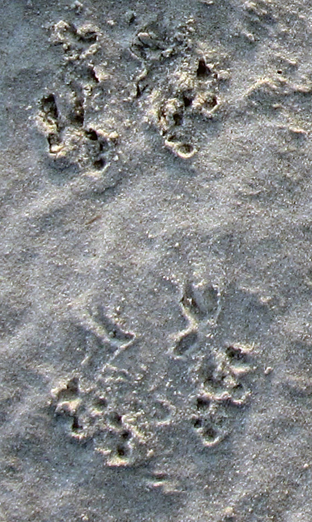
The first leap in logic – how did I know a Southern toad (Bufo (Anaxyrus) terrestris) was the tracemaker – was the easiest to make, as I’ve often seen their tracks in sandy patches of maritime forests and coastal dunes. These hardy amphibians leave a distinctive bounding pattern, with the front-foot impressions together and just preceding the rear-foot ones; the toes of their front feet also point inward. In the best-expressed tracks, you will see four toes on the front feet and five toes on the rear.

Close-up of bounding pattern (from lower left of previous photo), showing front-foot impressions just in front of and more central than the rear feet impressions. Direction of movement is from bottom to top of photo. (Photograph enhanced to bring out details, but originally taken by Gale Bishop.)

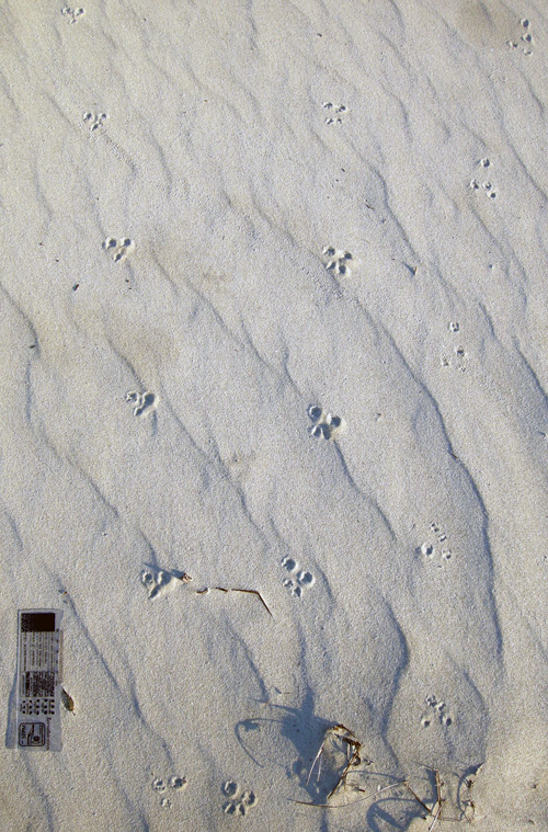
The only other possible animal that could make a trackway pattern confusable with a toad in this environment is a southeastern beach mouse (Peromyscus polionotus). Still, mice mostly gallop, in which their rear feet exceed their front feet as they move. Mouse feet are also very different from those of a toad, with toes on both feet all pointing forward (remember, toad toes point inward). So although dune mice live in the same environment as these tracks, these weren’t mouse tracks. The only alternative tracemakers would be spadefoot toads (Scaphiopus holbrookii) or a same-sized species of frog, such as the Southern leopard frog (Rana sphenocephala). But neither of these species is as common in coastal dunes as the Southern toad, so I’ll stick with my identification for now.

Mouse tracks – probably made by the Southeastern beach mouse (Peromyscus polionotus) – on costal dunes of Little St. Simons Island, Georgia. The two trackways on the left are moving away from you, whereas the one on the trackway on the right is heading toward you. All three show a gallop pattern, in which the larger rear feet exceeded the front feet. Scale = 10 cm (4 in). (Photograph by Anthony Martin)

The second conclusion – the types of behaviors and their order – came from first figuring out the direction of travel by the tracemaker, which from the lower left of the photo toward its middle. This shows straight-forward hopping up to the point where it stops.

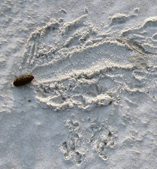
From there, it gets really interesting. The wide groove extends to the left past the line of travel and had to be made by the posterior-ventral part of the toad’s body (colloquially speaking, its butt). This, along with the disturbed sand on either side of the groove, shows that the toad turned to its right (clockwise) and backed up with shuffling movement. That’s when it deposited its scat, which I’ve also seen in connection with toad tracks (and on St. Catherines, no less). This really helped me to nail down the identity of the tracemaker, almost being able to declare, “Hey, I know that turd!”

Southern toad bounding pattern that abruptly stops, followed by clockwise turning, backing up, and, well, making a deposit. (Photograph by Gale Bishop, taken on St. Catherines Island.)

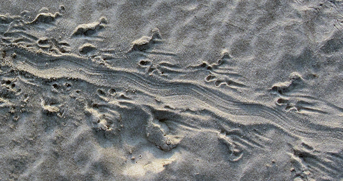
How about the alternate walking? Turns out that toads don’t just hop, but also walk: right side, left side, right side, and so on. This pattern – also called diagonal walking by trackers – is in the remainder of the photo (with the direction of movement left to right). When toads do this, the details of their front and rear feet are better defined, and you can more clearly see the front foot registers in front of the rear and more toward the center line of the body.

This side-by-side movement is also what imparted a slight sinuosity to the central body dragmark, which was from the lower (ventral) part of its body, or what some people would call “belly.” In my experience, most people are very surprised to find out that toads can walk like this, which I can only attribute to sample bias. In other words, they’ve only seen frogs and toads hop away from them when startled by the approach of large, upright bipeds.

Close-up of alternate walking pattern and body dragmark made by Southern toad. Direction of movement is from upper left to lower right. (Photograph enhanced to bring out its details, but original taken by Gale Bishop on St. Catherines Island.)

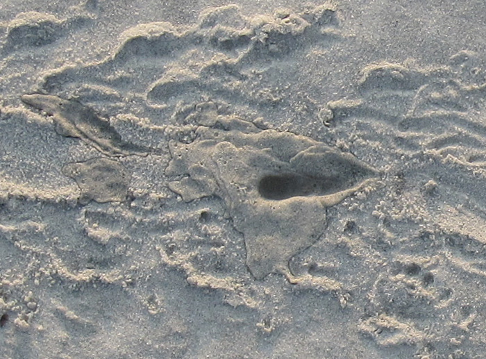
But wait, what are those two dark-colored depressions in the center of the alternate-walking trackway? Well, it doesn’t take much imagination to figure those out, especially if you’ve already had a couple of cups of coffee. Yes, these are urination marks, and even more remarkable, there are two of them in the same trackway. So not only did this toad do #2, but also #1 twice.

Southern toad urination mark #1, not too long after doing #2. (Photograph by Gale Bishop.)

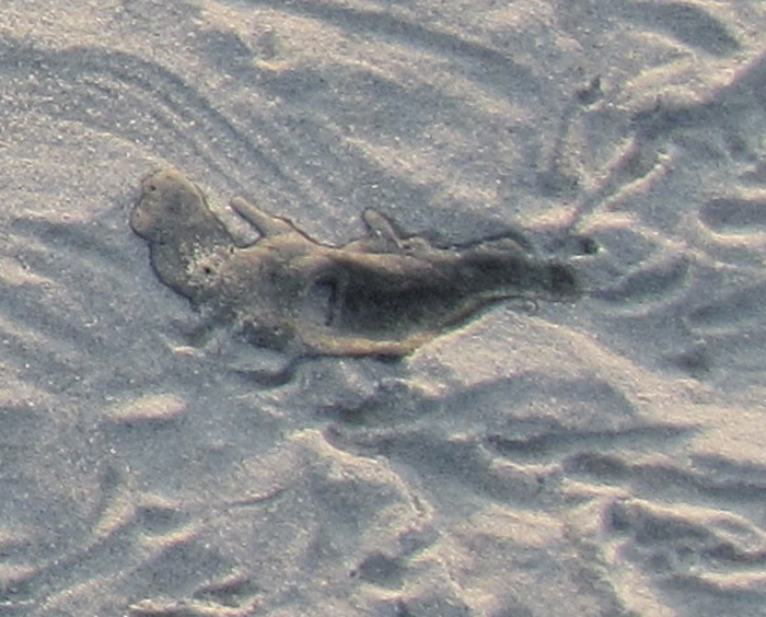
Urination mark #2 , which you might say was #2 of #1, but with both #1’s after #2, or, oh, never mind.

Notice that the second mark seems to have had less of a stream to it, which makes sense in a way that I hope doesn’t require any more explanation or demonstration.

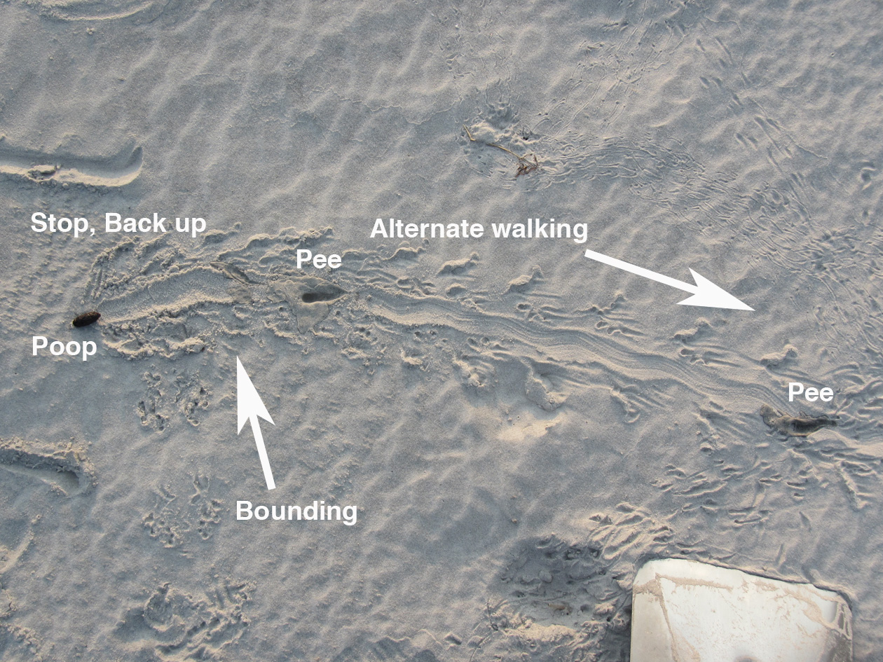
So to answer to one of the questions above – what signified the changes in behavior – you have to look for the interruptions in the patterns, much like punctuation marks in a sentence. The commas, semi-colons, colons, dashes are all part of a story too, not just the words.

The summary interpretation of what happened. Let’s just say that this frog (or toad, whatever) didn’t come a courtin’.

Through the series of photos Gale shared in an album on Facebook, he also showed that he was following a protocol all good trackers do: he changed his perspective while observing the traces. Likewise, I teach my students to use this same technique when presented with tracks and other traces, that it’s a good idea to walk around them. While doing this, they see changes in contrast and realize how the direction and angle of light on the traces alters their perceptions of it. At some points, a track or other trace may even “disappear,” then “reappear” with maximum clarity with just a few more steps.

A different perspective of the same traces, viewed from another angle. Do you notice something new you didn’t see in the previous photo and its close-ups? (Photograph by Gale Bishop, taken on St. Catherines Island.)

Now, because I’m also a paleontologist, this interesting series of traces also prompts me to ask: what if you found this sequence of traces in the fossil record? Well, it’d be a fantastic find, worthy of a cover story in Nature. (That is, if the tracks somehow went across the body of a feathered dinosaur.) Right now, I can’t think of any trace fossils like this coming from vertebrates – let alone toads or frogs – so let’s go to invertebrate trace fossils for a few examples of similarly interconnected behaviors preserved in stone.

In 2001, a sequence of trace fossils was reported from Pennsylvanian Period rocks (>300 million years old), in which a clam stopped, fed, and burrowed along a definite path, with all of its behaviors clearly represented and connected. The ichnologists who studied this series of trace fossils – Tony Ekdale and Richard Bromley – reckoned these behaviors all happened in less than 24 hours; hence the title of their paper reflected this conclusion.

Ichnologists have a sometimes-annoying and always-confusing practice of naming distinctive trace fossils, giving them ichnogenus and ichnospecies names. (For a detailed discussion of this naming method, I talked about it in another blog from the dim, dark, distant past of 2011 here.) For instance, Ekdale and Bromley stated in their study that three names could be applied to the distinctive trace fossils made by a single clam, with each a different form made by a different behavior: Protovirgularia (burrowing), Lockeia (stopping), and Lophoctenium (feeding).

Along those lines, another ichnologist (Andy Rindsberg) and I also suggested that an assemblage of trace fossils in Early Silurian rocks (>400 million years old) of Alabama, with many different ichnogenera, were all made by the same species of trilobite. The take-home message of that study, as well as Ekdale and Bromley’s, is that a single species or individual animal can make a large number of traces. This also means that ichnodiversity (variety of traces) almost never equals biodiversity (variety of tracemakers).

So let’s go back to the toad traces, put on our paleontologist hats, and think about a “what if.” What if you found this series of traces disconnected from one another: the hopping trackway pattern, the diagonal walking pattern, the urination marks, the groove, and the turd, all found in disparate pieces of rock? Taken separately, such trace fossils likely would be assigned different names, such as “Bufoichnus parallelis,” “B. alternata,” “Groovyichnus,” “Tinklichnus,” and “Poopichnus.” (Please do not use these names beyond an informal, jovial, and understandably alcohol-fueled setting.)

Color, present-day version of the variety of traces made by a Southern toad (above), and a grayscale imagining of it fossilizing perfectly (below). Key for whimsically named ichnogenera in fossilized version: Bp = “Bufoichnus parallelis,” Ba = “Buofichnus alternata,” G = “Groovyichnus,” P = “Poopichnus,” and T = “Tinklichnus.” Please don’t cite this.

Granted, the environment in which Gale noted these traces – coastal dune sands – are not all that good for preserving what is pictured here, but other environments might be conducive to fossilization. To quote comedian Judy Tenuta, “It could happen!”

So if someone does find a fossil analogue to Gale’s evocative find on St. Catherines Island, I will understand their giving a name to each separate part, even if I won’t like it. The most important matter, though, is not what you call it, but what it is. And in this case, the intriguing story of toiletry habits left in the sand one July morning by a Southern toad is worth much more than any number of names.

Further Reading

Ekdale, A.A., and Bromley, R.G. 2001. A day and a night in the life of a cleft-foot clam: Protovirgularia-Lockeia-Lophoctenium. Lethaia, 34: 119–124.

Halfpenny, J.C., and Bruchac, J. 2002. Scats and Tracks of the Southeast. Globe Pequot Press, Guilford, Connecticut: 149 p.

Jensen, J.B. 2008. Southern toad. In Jensen, J.B., Camp, C.D., Gibbons, W., and Elliott, M.J. (editors), Amphibians and Reptiles of Georgia. University of Georgia Press, Athens, Georgia: 44-46.

Rindsberg, A.K., and Martin, A.J. 2003. Arthrophycus and the problem of compound trace fossils. Palaeogeography, Palaeoclimatology, Palaeoecology, 192: 187-219.

Going Hog Wild on the Georgia Barrier Islands

(The following is the third part of a series about traces of invasive species of mammals on the Georgia barrier islands and the ecological effects of these traces. Here is an introduction to the topic, the first entry about the feral horses of Cumberland Island, and the second entry about the feral cattle of Sapleo Island.)

Anytime I hear someone refer to a Georgia barrier island as “pristine,” I wince a little bit, smile, and say, “Well, bless your heart.” The truth is, nearly every island on the Georgia coast, no matter how beautiful, is not in a pristine state, having been considerably altered by humans over the past 4,500 years, whether these were Native Americans, Europeans, or Americans. These varying degrees of change are sometimes subtle but nonetheless there, denoted by the loss of original habitats and native species or the addition of non-native species.

Still, one Georgia barrier island comes close to fulfilling this idealistic label: Wassaw Island, which during its 1,000-year geologic history somehow escaped commercial logging, agriculture, animal husbandry, and year-round settlements. Partially because of this legacy, Wassaw is designated as a National Wildlife Refuge, and is reserved especially for ground-nesting birds. One of the ways this island works well as a refuge for these birds is – as of this writing – its “hog free” status, a condition that can be tested with each visit by looking for the obvious traces of this invasive species.

The interior of Wassaw Island, with maritime forest surrounding a freshwater wetland created by alligators, the rightful owners of the island. On Wassaw, there are no tracks or signs of feral hogs, qualifying it as a “pristine” island. (Photograph by Anthony Martin.]
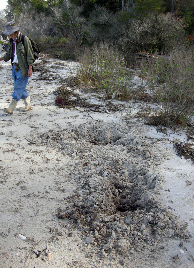
Contrast this with Cumberland Island National Seashore, where hogs run wild and freely. The huge pits here are in an intertidal zone of a beach on the northwest corner of the island. Naturalist Carol Ruckdeschel (background) for scale. (Photograph by Anthony Martin.)

Feral hogs (Sus scrofa) have a special place in the rogue’s gallery of invasive mammals on the Georgia barrier islands, and most people agree they are the worst of the lot. Hogs are on every large undeveloped island – Cumberland, Sapelo, St. Catherines, and Ossabaw – and they wreak ecological havoc wherever they roam. The widespread damage they cause is largely related to their voracious and omnivorous diet, in which they seek out and eat nearly any foodstuff, whether fungal, plant, or animal, live or dead. Their fine sense of smell is their greatest asset in this respect: every time I have tracked feral hogs, their tracks show head-down-nose-to-the-ground movement as the norm, punctuated by digging that uses a combination of their snouts and front hooves to tear up the ground in their quest for food. In other words, they generally act like, well, you know what.

Most importantly from the standpoint of native animals that try to live more than one generation beyond a single hog meal, feral hogs eat eggs. Hence ground-nesting birds and turtles are among their victims, and hogs are quite keen on eating sea turtle eggs. Mothers of all three species of sea turtles that nest on the Georgia coast – loggerhead (Caretta caretta), green (Chelonia mydas), and leatherback (Dermochelys coriacea) – dig subsurface nests filled with 100-150 eggs full of protein and other nutrients, making tempting targets for any free-ranging feral hogs. Similarly, hogs also threaten another salt-water turtle, the diamondback terrapin (Malaclemys terrapin); this turtle lays its eggs in shallow nests near the edges of salt marshes, which hogs manage to find. Conservation efforts to save diamondback terrapins from human predation have mostly succeeded (it used to be a tasty ingredient in soups), but hogs can’t read and don’t discriminate when it comes to eating eggs. Here is where feral hogs are particularly dangerous as an invasive species: unlike feral horses or cattle, which “merely” degrade parts of their ecosystems: feral hogs can contribute directly to the extinction of native species. As I often tell my students, if you want to cause a species to go extinct, stop it from reproducing.
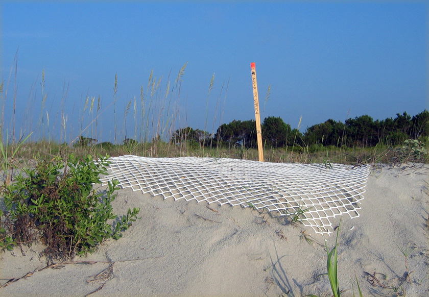
Sea-turtle nest on Sapelo Island, marked by a stake and protected by plastic fencing to prevent feral hog and raccoon depredation of its eggs. An individual raccoon would only eat about 1/3 of the eggs in a sea-turtle nest, whereas pigs would just keep on eating. (Photograph by Anthony Martin.)

As an ichnologist, though, what astounds me the most about these hogs is the extremely wide ecological range of their traces. I have seen their tracks – often made by groups traveling together – in the deepest interiors of maritime forests, in freshwater wetlands, and crossing back-dune meadows, high salt marshes, coastal dunes, and beaches. If their traces became trace fossils, paleontologists would refer to them as a facies-crossing species, in which facies (think “face”) are the identifiable traits of a sedimentary environment preserved in the geologic record. Based on their tracks and sign, they are ubiquitous in terrestrial and marginal-marine environments. Oh, and did I mention they are also good swimmers? Swimming across a tidal channel at low tide is an easy feat for them, enabling hogs to spread from island to island, without the assistance of humans.
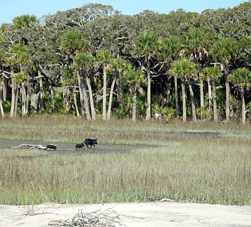
Run away, run away! Feral hogs in a St. Catherines Island salt marsh, consisting of two juveniles and an adult, do not stick around to see whether humans are going to shoot them; they just assume so. This sighting, along with their widespread tracks and other traces, show how feral hogs can occupy and affect nearly every environment on a Georgia barrier island. (Photograph by Anthony Martin.)

So to better understand why feral hogs are such successful invaders of the Georgia islands, it’s helpful to think about their evolutionary history. As expected, this history is complicated, just like that of any domesticated species in which selective breeding narrowed the genetic diversity we see today. About 15 subspecies of Sus scrofa have been identified, making its recent family tree look rather bushy. Based on genetic studies, divergence between wild species of Sus scrofa (so-called “wild boars”) and various subspecies may have happened as long ago as 500,000 years ago in Eurasia, although humans did not capture and start breeding them until about 9,000 years ago.
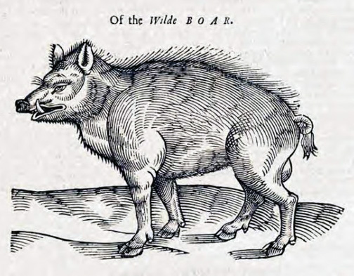
Depiction of a European wild boar from 1658, in The History of Four-Footed Beasts and Serpents by Edward Topsell. Original image from a woodcut, digital image in Wikipedia Commons here.

The closest extant relatives to these hogs native to North America are peccaries, which live in the southwestern U.S., Central America, and South America. However, peccaries are recent migrants to North America, and only one Pleistocene species (Mylohyus nasutus) is known from the fossil record of the eastern U.S. This means that the post-Pleistocene ecosystems of the eastern U.S., and especially those of the Georgia barrier islands, have never encountered anything like these animals. Also, unlike the feral horses of Cumberland Island and the feral cattle of Sapelo Island, the feral hogs of the Georgia barrier islands were likely introduced early in European colonization of the coast, and may have started with the Spanish in the 16th century.

Unfortunately, part of the selective breeding of Eurasian hogs was for early sexual maturity and large litter sizes. Female feral hogs can reach breeding age at 5 months, and litters typically have 4-8 piglets, but can be greater than 12; females also can produce three litters in just more than a year. Do the math, and that adds up to a lot of pigs in a short amount of time. Furthermore, on Georgia barrier islands with few year-round human residents, the only predation pressures young piglets face daily include raptors (no, not that kind of raptor) or alligators. This means young hogs reach sexual maturity soon enough to rapidly overrun a barrier island.
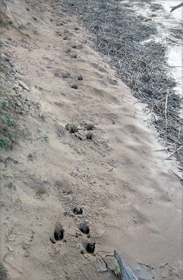
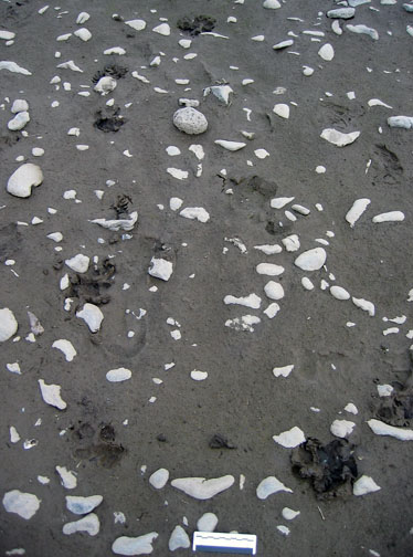
Feral hog trackway in a sandy intertidal zone of Cumberland Island, showing a typical gallop pattern (four tracks together –> space –> four tracks together), symbolizing how they are running roughshod over this and other islands. (Photograph by Anthony Martin.)

Yet as we have learned in North America, and particularly on the Georgia barrier islands, feral hogs rapidly revert to their Pleistocene roots. Similar to the feral cattle of Sapelo Island, these hogs are rarely seen by people, especially on islands where humans regularly hunt them. Every time I have spotted them on Cumberland, Sapelo, St. Catherines, or Ossabaw, they instantly turn around, briefly flash their potential pork loins and ham hocks, and flee. As anyone who has raised hogs can tell you, pigs are smart and learn quickly. Hence I imagine that after only one or two shootings of their siblings or parents, they readily associate upright bipeds with imminent death, especially if these bipeds are carrying boomsticks.” (Speaking of which, I know of at least one sea turtle researcher who does his part to decrease feral hog populations – while also feeding the local vultures – through his able use of such a baby-sea-turtle-protection device.)

Hence much of what we learn about these free-ranging pigs and their behaviors in the context of the Georgia barrier islands is from their traces. Among the most commonly encountered feral hog traces are:

• Tracks

• Rooting pits

• Wallows

• Feces

Feral hog tracks are potentially confused with deer tracks, as they both consist of paired hoofprints and overlap in their size ranges, which are about 2.5-6 cm (1-2.5 in) long. Nonetheless, feral hog tracks are less “pointed,” have nearly equal widths and lengths, rounded ends, and the two hoofs often splay. Two dew claws – vestigial toes – frequently register behind the hoofs, especially when hogs step into soft sand or mud or are running. Trackways normally show indirect register of the rear foot onto the front footprint in a diagonal walking pattern, but can also display a whole range from slow walk to full gallop patterns. With repeated use of pathways, trackways become trails, although I’m not sure if hogs are merely using and expanding previously existing whitetail deer trails, if they are blazing their own, or a combination of the two. (I suspect the last of these is the most likely.)
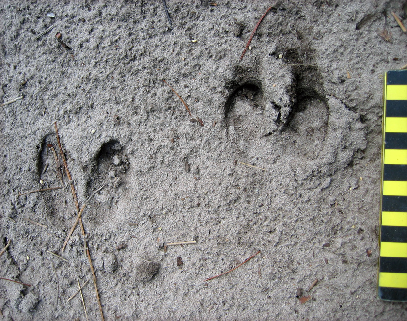
Feral hog tracks, showing nearly equal lengths and widths, rounded ends, and splaying of hooves, all three of which help to distinguish these from whitetail deer tracks. Scale in centimeters. (Photo by Anthony Martin, taken on Sapelo Island.)
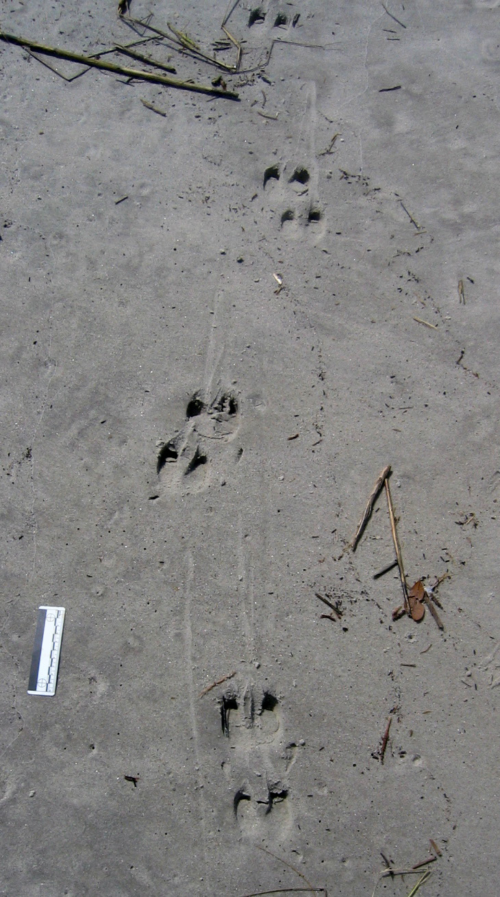
Feral hog trackway on upper part of a sandy beach (moving parallel to shore), showing slow diagonal walking pattern, verified by hoof dragmarks between sets of tracks. Scale = 10 cm (4 in). (Photo by Anthony Martin, taken on St. Catherines Island.)

Rooting pits are broad but shallow depressions – as much as 5 m (16 ft) wide and 30 cm (1 ft) deep – that are the direct result of feral hogs digging for food. In most instances, I suspect they are going for fungi and plant roots, but they probably also eat insect larvae, lizards, small mammals, and any other animals that live in burrows. These pits are typically in maritime forests and back-dune meadows, but I have seen them in salt marshes and dunes, and, most surprisingly, in the intertidal areas of beaches. What are they seeking and eating in beach sands? I think anything dead and buried that might be giving off an odor. I have even seen their tracks associated with broken carapaces of horseshoe crabs (Limulus polyphemus), a menu item that never would have occurred to me if I had not seen these traces.
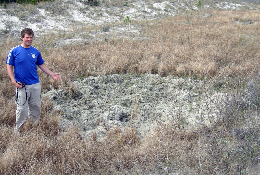
Rooting pit in back-dune meadow on St. Catherines Island. Former student, who answers to the parent-given appellation of “Andrew,” for scale. (Photograph by Anthony Martin.)
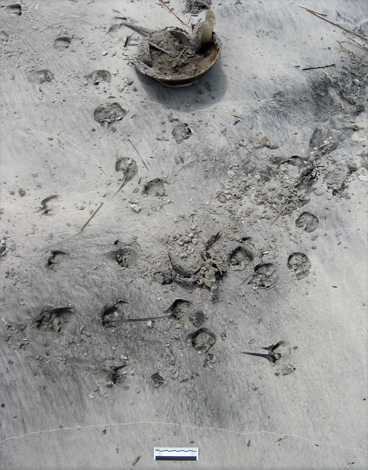
Evidence of feral hog feeding on a horseshoe crab (Limulus polyphemus). All I can say is, it must have been really hungry. (Photo by Anthony Martin, taken on St. Catherines Island.)

Wallows are similar in size and appearance to rooting pits, but have a different purpose, which is to provide hogs with relief from both the Georgia summer heat and biting insects that invariably go with this heat. These structures are often near freshwater wetlands in island interiors, but I’ve seen them next to salt marshes, too. If these wallows intersect the local water table, they also make for attractive little ponds for mosquitoes to breed, meaning these hog traces indirectly contribute to the potential spread of mosquito-borne diseases.
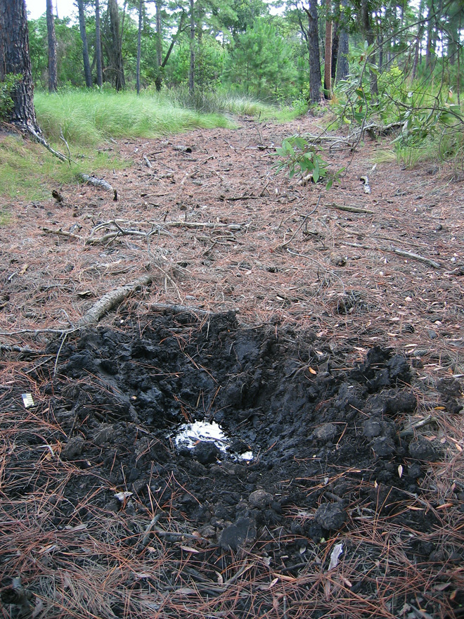
Wallow in maritime forest, Sapelo Island, with a standing pool of water indicating the local water table at the time. (Photo by Anthony Martin.)

Hog feces may look initially like deer pellets, but tend to aggregate in clusters. Most of the ones I have seen are filled with vegetation, but the extremely varied diets of feral hogs means you should expect nearly anything to show up in their scat.
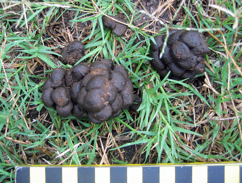
Feral hog feces on Sapelo Island, which is more clumped than that of whitetail deer. Scale in centimeters. (Photo by Anthony Martin, taken on Sapelo Island.)

Which of these traces would make it into the fossil record? I would certainly bet on at least some of their tracks getting preserved, based on the sheer ubiquity of these traces in nearly every sedimentary environment of a Georgia barrier island. Other likely traces would be their pits and wallows, although their broad size and shallow depths would make them difficult to recognize unless directly associated with tracks. Feces would be the least likely to make it into the fossil record as coprolites, unless these contained a fair amount of bone or other mineralized stuff, which could happen with hogs.

What to do about these hogs, and how to decrease the impacts of their traces? Well, as most people know, pigs are wonderful, magical animals that were domesticated specifically for their versatile animal protein. So one solution is more active and year-round hunting of hogs, and using them to supplement breakfasts, lunches, and dinners of local residents on the Georgia coast, a neat blend of reducing a harmful feral species while encouraging a chic “locavore” label on such food.

However, the sheer numbers of hogs on some of the islands would likely require a more systematic slaughter to make a dent in their numbers, an approach that would probably deter any ecotourism unrelated to hog hunting. (Let’s just say that firearms and bird watching are an uneasy mix.) The introduction of native predators is another possible solution. For example, Cumberland Island has a population of bobcats (Lynx rufus) that was introduced primarily to control the whitetail deer population, but these cats probably also take a toll on the feral hogs (although how much is unknown). I have even heard suggestions of reintroducing red wolves (Canis rufus) to a few of the islands. These pack-hunting predators were native to the southeastern U.S. before their extirpation by fearful European settlers, and probably would reduce feral hog populations, but just how much of an impact they would have is hard to predict.

In summary, the feral horses, cattle, and hogs of the Georgia barrier islands have significant effects on the ecology and geology of the Georgia barrier islands, and will continue to do so until creative solutions are proposed and implemented to reduce and otherwise manage their numbers. In the meantime, though, these invasive species present opportunities for us to study their traces, learn more about their unseen behaviors, and compare these behaviors with their evolutionary histories. More science is always good, and in this respect, the Georgia barrier islands are the gifts that keep on giving.
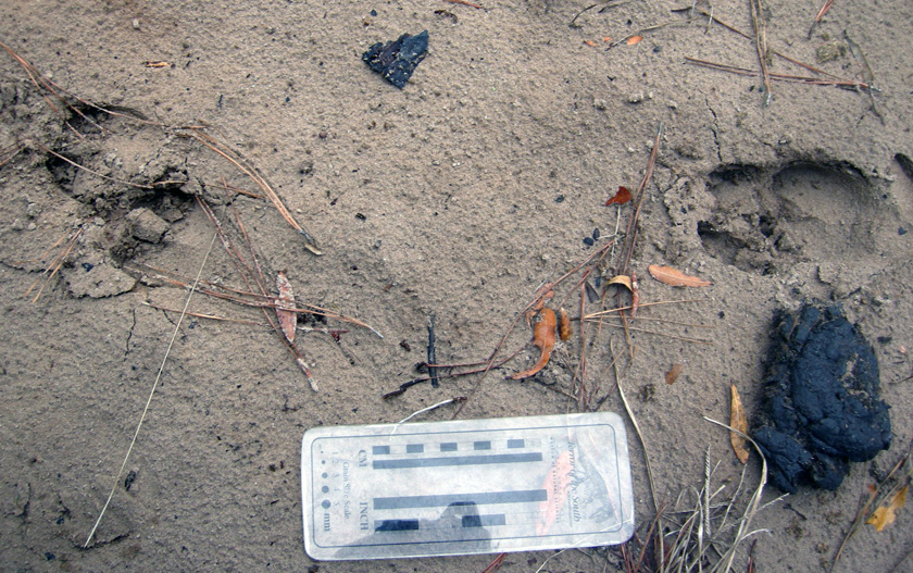
Traces of feral mammals on Sapleo Island: feral hog tracks strolling past a piece of feral cattle scat in a sandy road next to a maritime forest. What is the fate of these invasive species on the Georgia barrier islands, and how will these environments continue to change because of their presence? (Photo by Anthony Martin, taken on Sapelo Island.)

Further Reading

Ditchkoff, S.S., and West, B.C. 2007. Ecology and management of feral hogs. Human-Wildlife Conflicts, 1: 149-151.

Giuffra, E., Kijas, J.M.H., Amarger, V., Carlborg, Ö., Jeon, J.-T., and Andersson, L. 2000. The origin of the domestic pig: independent domestication and subsequent introgression. Genetics, 154: 1785-1791.

Mayor, J.J., Jr., and Brisbin, I.L. 2008. Wild Pigs in the United States: Their History, Comparative Morphology, and Current Status. University of Georgia Press, Athens, Georgia: 336 p.

Taylor, R.B., Hellgren, E.C., Gabor, T.M., and Ilse, L.M. 1998. Reproduction of feral pigs in southern Texas. Journal of Mammalogy, 79: 1325-1331.

Wood, G.W., and Roark, D.N. 1980. Food habits of feral hogs in coastal South Carolina. The Journal of Wildlife Management, 44: 506-511.
Tracking the Wild Horses of Cumberland Island

(The following post is one of a series about traces of important invasive species of mammals on the Georgia barrier islands and the ecological effects of these traces. An introduction to this topic from last week is here.)

Perhaps the most charismatic yet problematic of non-native animals on any of the Georgia barrier islands are the wild horses (Equus caballus) of Cumberland Island. These horses are the source of much controversy, which becomes even more apparent whenever anyone tries to apply some actual science to them. So I will talk about them here from my perspective as a paleontologist and geologist in the hope that this will add another dimension to what is often presented as a two-sided and emotional argument.

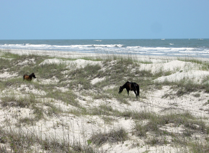
Ah, the wild horses of Cumberland Island, Georgia, roaming free since the time of the Spanish in a pristine, unspoiled landscape, grazing contently on the sea oats and strolling through the coastal dunes, in perfect harmony with nature. How much of the preceding sentence is wrong? Almost all of it. If you want to find out why, please read on. But if your mind is already made up about the feral horses of Cumberland and you don’t want to hear anything bad said about them, then you might like this site. (Photograph by Anthony Martin.)

Cumberland Island, much of which is part of the U.S. National Park system as a National Seashore, is the only Georgia barrier island with a population of feral horses. Nevertheless, despite their uniqueness and fame – the latter figuring as key attractions in advertisements about Cumberland and inspiring dreamy book titles – their origins remain murky. One of the recurring romanticized claims is that these horses descended from livestock brought there by Spanish expeditions in the 16th century. This idea is reassuring to the people who repeat it for two reasons:

(1) It establishes horses as living in the landscape for a long time (especially by American standards), meaning that their presence there now is considered “natural.”

(2) It lends itself to the comforting thought that the horses connect to a European cultural heritage, putting an Old World imprint on a New World place.

However, once said enough times, such just-so stories become faith-based and any evidence contradicting them is not tolerated. Thus even when genetic studies of the Cumberland horses show they are not appreciably different from populations of horses on other islands of the eastern U.S. (arguing against a purely Spanish origin), any questioning of the stated premise – in my experience – provokes angry responses from its defenders.

I suspect this virulent reaction is a direct result of challenging both the “naturalness” and “cultural heritage” of the horses on Cumberland. In reality, though, these are opposing values. After all, an admission that these feral horses came from European stock at any point during the past 500 years supports how they clearly do not belong on Cumberland Island, or anywhere else in the Western Hemisphere if we’re talking about the last 10,000 years or so. In other words, the point is moot whether the current horse population originated in the 16th, 17th, 18th, 19th, or 20th century, or is a mixture of older and newer stock. If only horses could talk, then we would know for sure. (A detailed history of the horses on Cumberland Island is provided here for anyone interested in learning more about this.)

Arguments of heritage aside, these horses are newcomers in a geological and ecological sense. The fossil record of the modern Georgia barrier islands backs this up, as some of the islands (including Cumberland) have sediments more than 40,000 years old, but none have body or trace fossils of horses, or anything like a horse. Although three species of horses were living on the mainland part of North America during the Pleistocene Epoch until their respective extinctions more than 10,000 years ago, none were known to have inhabited any of the barrier islands, Pleistocene or recent. The closest ancient analogue to horses on any of the Georgia barrier islands would have been bison (Bison bison), but their bones are rare. This scarcity leads paleontologists to wonder whether the islands ever had self-sustaining populations of large herbivores.

So with all of that human history and pre-history in mind, the traces made by the feral horses of Cumberland and their ecological effects are exceptional to it and every other Georgia barrier island, and hence worth our attention. Just to keep this simple, I will cover three primary types of traces made by these horses. What these traces all have in common (other than being made by a horse, of course) is the decidedly negative impacts these have on the native plants and animals of Cumberland, including keystone species in the oft-labeled “pristine” ecosystems of the island.

Tracks and trails – These traces are the abundant and easily spotted on Cumberland, even to someone with little or no training in ichnology. Horses are unguligrade, which means they are walking on their toenails (unguals), and the ungual (more popularly called a hoof) is on a single digit. Hooves make circular to slightly oval compression shapes, but if preserved in the right substrate – like a firm mud or fine sand – they will show a “Pac-Man”-like form. Front-foot (manus) tracks are slightly larger than rear-foot (pes) tracks; manus impressions are 11-14 cm (4.3-5.5 in) long and 10-13 cm (4-5.1 in) wide, whereas pes impressions are 11-13 cm (4.3-5.1 in) long and 9-12 cm (3.5-4.7 in) wide, with variations in size depending on ages of the horses making the tracks.

Trackway of feral horse moving through the coastal dunes of Cumberland Island. Note the diagonal walking pattern and how front- and rear-foot impressions merge to make oblong compound traces.

An important point to keep in mind when tracking horses or any other hoofed animals is that their feet readily cut through sediments and vegetation, leaving much more sharply defined and deeper impressions than padded feet of an equivalent-sized animal. Because Georgia-coast sands contain whitish quartz and darker heavy minerals, these contrasting sand colors help to outline horse tracks on surfaces and in cross-section as deep and sharply defined structures that cut across the bedding.

When asked to think about horses in motion, it might be tempting to imagine them galloping, especially along a beach at sunset. Nonetheless, a horse would tire quickly if it galloped all day, especially for no valid reason. Instead, its normal gait is a slow walk, which causes the rear foot to register partially on top of the front-foot impression, but slightly behind; with a slightly faster walk, the rear foot will exceed the front-foot impression. The overall trackway pattern then is what many trackers call “diagonal-walking,” as the right-left-right alternation of steps can be linked with imaginary diagonal lines. Trackway width, also known as straddle, is about 20-40 cm (8-16 in) if a horse was just walking normally, but narrows noticeably once it starts picking up speed.

Feral-horse tracks on Cumberland Island, a close-up of the same trackway shown in the previous photo. This one was likely doing a slow walk, with indirect register of the rear foot just behind and onto the front-foot impression. The scale (my shoe) is a size 8½ mens. (Photograph by Anthony Martin.)

Given enough back-and-forth movement along preferred paths, repeating and overlapping trackways result in trails, which can be picked out as linear bare patches of exposed sand or mud cutting through vegetation. Because horses are much larger than the native white-tailed deer (Odocoileus virginianus) on Cumberland, their trails are considerably wider.

Feral-horse trail along the edge of a low salt marsh where they have trampled and overgrazed the smooth cordgrass in that marsh (Spartina alterniflora). (Photograph by Anthony Martin, taken on Cumberland Island.)

Chew marks – Horses are grazers and low-level browsers, and they eat a wide variety of vegetation on Cumberland. The most important plant species they eat through grazing are smooth cordgrass (Spartina alterniflora), sea oats (Uniola paniculata), and live oak (Quercus virginiana).  All three of these plants are keystone species in their respective ecosystems: smooth cordgrass predominates in the low salt marshes, sea oats are the mainstay plants of coastal dunes, and live oaks are the largest and most long-lived trees in the maritime forests. Their effects of horses consuming  smooth cordgrass and sea oats is straightforward, as these plants hold in sediments in place keep them from eroding, but how do horses affect live oaks? They eat the seedlings, which means that older oaks are being replaced by younger ones at a slower rate.

Grazing traces consist of clean cuts of vegetation within a vertical swath and over a broad area. Horses, unlike white-tailed deer, have teeth on both their upper and lower jaws, thus they shear plants on the branches, stems, or leaves. In contrast, deer leave more ragged marks, as they only have teeth on their lower jaws and hence have to pull on vegetation to break it off. Horses also can make a browse line, which is an abrupt horizontal line of decreased vegetation at a certain consistent height that more-or-less correlates with the average head height of the horses.

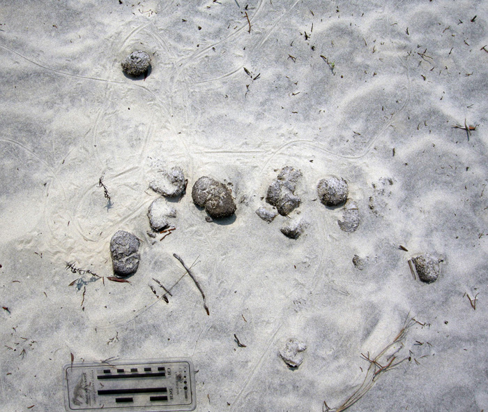
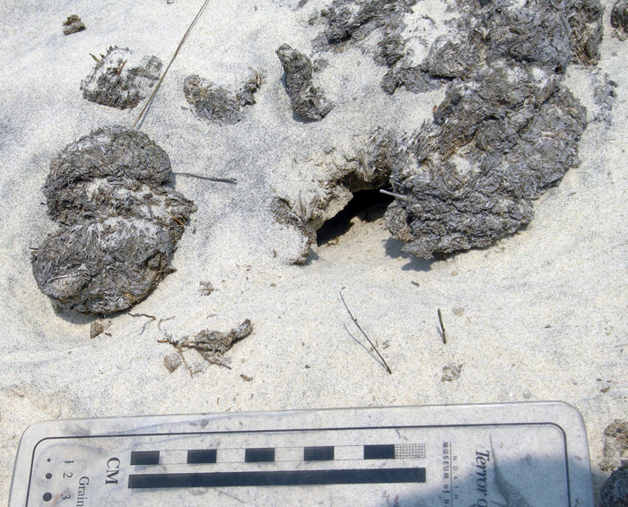
Dung – During any given stroll on Cumberland, you cannot avoid seeing, smelling, and stepping in horse feces. This abundance of fecal material means that the feces are not being recycled quickly enough into the ecosystems, which implies that native populations of dung beetles are overwhelmed by such abundance. I have seen a few traces of dung beetles in fresh piles of feces, but no matter how hard I have looked, I have yet to witness great thundering herds of beetles rolling balls of dung across the Cumberland Island landscape.

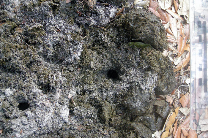
An impressive collection of horse dung, which was probably dropped by a single horse. Note the small holes in the middle, which were likely made by dung beetles that tunneled into this rich supply of food for their offspring.

Close-up of those probable dung-beetle burrows, some with short trails attached. The white quartz sand sprinkled on top shows how it was pulled up by beetles from underneath the dung pile and onto the top surface, thus giving a minimum depth of the burrows. (Both photographs by Anthony Martin, taken on Cumberland Island.)

One of the more interesting ecological consequences of horse dung I have seen on Cumberland is how it influences the behavior of smaller animals as pellets or piles form a microtopography. For example, on some of the dunes near Lake Whitney on Cumberland – the largest body of fresh water on any of the Georgia barrier islands – I was surprised to see that small lizards – probably skinks – were moving around the dung piles or burrowing under them.

Horse droppings as a part of the landscape for small lizards. Here their tracks, accompanied by tail dragmarks, wind around partially buried feces in a sand dune. (Photograph by Anthony Martin, taken on Cumberland Island.)

Small lizard burrow entrance immediately below a horse pellet, showing its use as a sort of roof. This could probably inspire some clever statement on shingles and, well, you know, but I’ll refrain for now. (Photograph by Anthony Martin, taken on Cumberland Island.)

All three categories of traces – tracks, chew marks, and dung – can be found together in ecosystems wherever horses are trampling, grazing, and defecating, respectively.

So now let’s put on our paleontologist or geologist hats (not to be confused with archaeologist hats) and ask ourselves about the likelihood of such traces making it into the fossil record, and how we would recognize them if they did. Their likelihood of preservation, in order, would be tracks, feces, and chew marks. Tracks would be evident as large compression shapes in horizontal bedding planes or deep disruptions of bedding planes in vertical section. Feces, or their fossil versions called coprolites, might get preserved, although herbivore feces, filled with vegetative material, is less likely to make it into the fossil record compared to carnivore feces, which may have lots of bone material in it. The last of these – chew marks – would be nearly impossible to tell from normal tearing and other degradation of plant material before it became fossilized. Good luck on that.

But could the ecological damage caused by an invasive species, in which the introduction of a species serve as a sort of trace fossil in itself? In the case of horses or ecologically similar animals, subtle changes to the landscape over time might take place. This experiment actually has been done on Assateauge Island (North Carolina), which also has a feral horse population. In areas where horses were excluded by fences, the dunes were on average 0.6 meters (2 ft) feet higher than those of overgrazed and trampled dunes. Geologists conducted another study done on Shackleford Banks (North Carolina) in which they examined areas where fences had separated non-horse from horse-occupied parts of the island. These geologists similarly found that horses caused dunes to be less than 1.5 m (5 ft) high, whereas dunes without horses were as much as 3.5 m (11.5 ft) high. This meant that storms more easily penetrated the barriers provided by coastal dunes, more commonly resulting in storm-washover fans.

This change in the coastal geology of back-dune areas also means that ground-nesting shorebirds will become less common, as their nests and nestlings will be drowned or buried more frequently. Horses also are known to step on shorebird eggs and nests, or can scare away parents from nests, which increases the likelihood of egg or nest predators taking out the next generation of shorebirds.

If any horses made it to the Georgia barrier islands during the Pleistocene and established breeding populations, a geologic sequence following their arrival would look like this, from bottom to top: high dunes suffused with root traces (before horses); lower dunes corresponding with fewer root traces and deep disruptions of bedding (horse tracks); increased numbers of storm-washover fans; and a high salt-marsh. In short, a geologist would see an overall progression from a dune-dominated shoreline to a high salt marsh. Similarly, a paleontologist might see a decrease in root trace fossils and shorebird nests, eggshells, and tracks, possibly culminating in local extinctions of each.

This is your Georgia coast.

This is your Georgia coast with horses. Any questions?

Top panorama is of high-amplitude coastal dunes and well-vegetated back-dune meadows on Sapelo Island, whereas the bottom panorama is of low-amplitude dunes with no appreciable back-dune meadows on Cumberland Island. (Both panoramas based on photos taken by Anthony Martin.)

Based on what we know then, should the feral horses of Cumberland Island be removed? Yes. Will they be removed? Probably not. However, regardless of happens, I will keep teaching about the horses of Cumberland Island and their traces, both as an educator and a concerned citizen. Perhaps with enough awareness, circumstances will change for the better so that Cumberland Island can not only remain a beautiful place, but also will become more like what it was before the arrival of horses there.

(Next week in this series about invasive mammal species of the Georgia barrier islands and their traces, I’ll cover a less inflammatory but still intriguing topic: the feral cattle of Sapleo Island.)

Further Reading

Buynevich, I.V., Darrow, J.S., Grimes, T.A.Z., Seminack, C.T., and Griffis, N. 2011. Ungulate tracks in coastal sands: recognition and sedimentological significance. Journal of Coastal Research, Special Issue 64: 334-338.

De Stoppalaire, G.H., Gillespie, T.W., Brock, J.C., and Tobin, G.A. 2004. Use of remote sensing techniques to determine the effects of grazing on vegetation cover and dune elevation at Assateague Island National Seashore: impact of horses. Environmental Management, 34: 642-649.

Dilsaver, L.M. 2004. Cumberland Island National Seashore: A History of Conservation Conflict. University of Virginia Press, Charlottesville, Virginia: 304 p.

Elbroch, M. 2003. Mammal Tracks and Sign: A Guide to North American Species. Stackpole Books, Mechanicsburg, Pennsylvania: 779 p.

Goodloe, R.B., Warren, R.J., Osborn, D.A., and Hall, C. 2000. Population characteristics of feral horses on Cumberland Island and their management implications. The Journal of Wildlife Management, 64: 114-121.

Sabine, J.B., Schweitzer, S.H., and Meyers, J.M. 2006. Nest Fate and Productivity of American Oystercatchers, Cumberland Island National Seashore, Georgia. Waterbirds, 29: 308-314.

Turner, M.G. 1987. Effects of grazing by feral horses, clipping, trampling, and burning on a Georgia salt marsh. Estuaries and Coasts, 10: 54-60.

Turner, M.G. 1988. Simulation and management implications of feral horse grazing on Cumberland Island, Georgia. Journal of Range Management, 41: 441-447.


Georgia Salt Marshes: Places Filled with Traces

The Georgia coast has long captured the attention of scientists interested in its biological and geological systems and how these two realms overlap. For example, starting in the 1950s, ecologists – people who study the connections between living and non-living things in ecosystems – began investigating the exchange of energy and matter between the plants and animals of the Georgia barrier islands. In particular, they were interested in the Georgia salt marshes, most of which are between the mainland and the upland portions of the barrier islands. Why study salt marshes in Georgia, and not somewhere else? And how do the traces of plants and animals in these marshes, such as root disturbances, scrapings, burrows, and feces, actually play a major role in the functioning of these ecosystems?

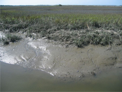
The muddy bank of a tidal creek in a typical salt marsh on St. Catherines Island, Georgia. See the traces? No? It’s a trick question: it’s made of nothing but traces. Photograph by Anthony Martin.

Georgia salt marshes are flat, extensive coastal “prairies” dominated by a tall, marine-adapted grass, smooth cordgrass (Spartina alterniflora) in their lowermost parts. These ecosystems turned out to be fantastic places for scientists to study basic principles of ecology, and are among the most productive of all ecosystems, besting or equaling tropical rain forests in this respect. Georgia salt marshes also represent about one-third of all salt marshes in the eastern U.S. by area. How did this happen?

Such an unusual concentration of salt marshes along the relatively small Georgia coastline is a result of several factors. One is its semi-tropical climate, only rarely dipping below freezing, which allows marsh plants and animals to thrive and actively participate in their ecosystems nearly year-round. Another is the high tidal range of the Georgia coast of about 2.5-3 meters (8-10 feet), which causes enormous amounts of organic material – living and nonliving – to get cycled in and out of the marshes by this moving water.

A third reason, and perhaps the most important, is what people did not do to the marshes, which was to develop them in ways that would have completely altered their original ecological characters. (Take a look at the barrier islands of New Jersey as examples of what could have happened in Georgia.) Salt marshes that were not drained, filled in, paved over, or otherwise irreparably altered could be studied for what they were, not what we supposed.

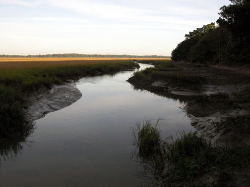
Salt marsh and tidal creek adjacent to a maritime forest on Cumberland Island. Fortunately, this is a typical sight on the Georgia barrier islands, which gladdens ecologists and lots of other people who prefer to see their landscapes unpaved.

The scientists interested in the Georgia salt marshes, among them Eugene (“Gene”) Odum, Mildred Teal, and John Teal, were astonished by the amount of organic matter produced in these marshes, especially in their lower parts, which were appropriately called low marsh. Amazingly, much of this flux is controlled by tides and just five species of organisms you can easily see any given day in these marshes:

  • Smooth cordgrass (Spartina alterniflora)
  • Ribbed mussels (Geukensia demissa)
  • Eastern oysters (Crassostrea virginica)
  • Marsh periwinkles (Littoraria irrorata)
  • Mud fiddler crabs (Uca pugnax)

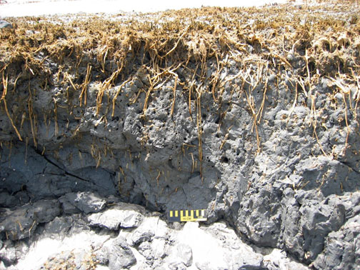
Just to oversimplify matters, but to assure that you get the big picture, the flow of matter and energy goes like this. Smooth cordgrass is the primary producer of organic material in the salt marshes, converting sunlight into food for it and, as it turns out, lots of other organisms. This is relatively easy for these plants because they are powered by intense Georgia sunlight much of the year. Smooth cordgrass also has extensive and complicated root systems, which help to hold most of the marsh muds in place when marshes are flushed by the tides. These roots locally change the chemistry of the surrounding mud and otherwise leave visible traces of their deeply penetrating networks, which are noticeable long after the plants had died and decayed.

Cross-section of a relict salt marsh preserved on Sapelo Island, Georgia, buried for about 500 years but just now being exhumed by shoreline erosion. See how deeply those roots of smooth cordgrass (Spartina alterniflora) penetrate the mud and still hold it in place? Modern ones do the same thing. Scale = 15 cm (6 in).

What produces the mud in a marsh? Mostly the ribbed mussels, oysters, and similar suspension-feeding animals, which: suck in water made cloudy by suspended clays; consume any useful organics that might be in that water; and excrete massive amounts of mud-filled feces, packaged with mucous as sand-sized particles. The oysters, along with cordgrass roots, stabilize the banks of tidal creeks, keeping these from washing away with each ebb tide.

If you’ve ever wondered what ribbed mussel (Geukensia demissa) feces look like, you’re in luck. Each one is only about 1 millimeter (0.04 inches) across, which makes them behave more like sand instead of much tinier clay particles. Also think of them as little packets of mud shrink-wrapped by mucous. Illustration by Anthony Martin, based on a figure by Smith and Frey (1985).

A view of what used to be a marsh surface – the relict marsh on Sapelo Island, that is – with stubs of long-dead smooth cordgrass accompanied by equally long-dead clusters of ribbed mussels (Geukensia demissa). Back in the day (about 500 years ago), these mussels were happily pumping out mud-filled feces, and their modern descendants are still doing the same thing. Sandal (left) is size 8½ (mens). Photograph by Anthony Martin.

Prominent clumps of eastern oysters (Crassostrea virginica), exposed at low tide in the middle of a tidal creek on Sapelo Island. These not only help to produce mud, but keep it in place, while also slowing down flow and helping to deposit mud. Photograph by Anthony Martin.

A close-up look at more oysters surrounded by smooth cordgrass, with both working together to bind and accumulate mud on Sapelo Island. Now that’s ecological teamwork! Photograph by Anthony Martin.

Both the cordgrass and oysters also baffle and otherwise slow down the water flow, causing mud – fecal or otherwise – to get deposited. In short, a Georgia salt marsh with its thick deposits of beautifully dark, rich, gooey mud, much of which consists of the traces of mussels and oysters, would cease to exist without these bivalves and smooth cordgrass, and would become more like an open lagoon.

Meanwhile, marsh periwinkles are constantly moving up and down the stalks and leaves of the smooth cordgrass, grazing on algae growing on the cordgrass. This activity causes visible damage to the plants, tearing them into small bits and pieces that fall onto the marsh surface.

Marsh periwinkles (Littoraria irrorata) doing what they do best, which is graze on the stalks and leaves of smooth cordgrass, leaving many traces from damaging these plants while also contributing plant debris to the marsh surface. Photograph by Anthony Martin, taken on Sapelo Island.

Fungi and bacteria further break down this “gentle rain from heaven” of cordgrass debris once it reaches the marsh surface. Here, mud fiddler crabs consume this stuff, along with any algae that might be growing on marsh surfaces. Their scrape marks and discarded balls of processed sediment are everywhere to be seen on the marsh surface and add to the sediment load of a marsh. Furthermore, as we may have learned in grade school, all animals poop, so in this way these fiddler crabs and other species of crabs living in the salt marshes donate even more enriched organic material. They also dig millions of burrows, some adorned by prominently pelleted turrets, churning the uppermost part of the marsh mud like earthworms would do to a soil in a forest or field.

Mud fiddler crabs (Uca pugnax) and their many traces on a salt marsh surface, including feeding pellets, scrape marks, and burrows. Photo by Anthony Martin, taken on Sapelo Island.

Mud-fiddler crab burrows exposed at low tide in a marsh, many with pellet-lined turrets. Why do they make these structures? Good question, which I’ll try to answer in the future. Photo by Anthony Martin, taken on Sapelo Island.

Hence you cannot go to a Georgia salt marsh and say, “I can’t see any traces,” unless you are closing your eyes or are otherwise sight deprived. The entire salt marsh is composed of traces, and these traces, which are the products of plant and animal behavior, actually control the ecology of the salt marshes. Thus I often refer to Georgia salt marshes as examples of “ichnological landscapes,” places that are the sum of all traces. This concept then better prepares us for viewing these and other Georgia coastal environments as places where geologists can begin to understand how organisms can leave their marks – both big and small – in the geologic record.

Further Reading:

Craige, B.J. 2001. Eugene Odum: Ecosystem Ecologist and Environmentalist. University of Georgia Press, Athens, Georgia: 226 p.

Odum, E.P. 1968. Energy flow in ecosystems; a historical review. American Zoologist, 8: 11-18.

Odum, E.P., and Smalley, A.E. 1959. Comparison of population energy flow of a herbivorous and a deposit-feeding invertebrate in a salt marsh ecosystem. Proceedings of the National Academy of Sciences, 45: 617-622.

Smith, J.M., and Frey, R.W. 1985. Biodeposition by the ribbed mussel Geukensia demissa in a salt marsh, Sapelo Island, Georgia. Journal of Sedimentary Research, 55: 817-825.

Teal, J.M. 1962. Energy flow in the salt marsh ecosystem of Georgia. Ecology, 43: 614-624.

Teal, J.M., and Teal, M. 1983. Life and Death of a Salt Marsh. Random House, New York: 274 p.

Teal, M., and Teal, J.M. 1964. Portrait of an Island. Atheneum, New York: 167 p. [reprinted by University of Georgia Press in 1997, 184 p.]