Most Intriguing Traces of the Georgia Coast, 2012

The end of another revolution of the earth around the sun brings with it many “best,” “most,” “worst,” “sexiest,” or other such lists associated with that 365-day cycle. Tragically, though, none of these lists have involved traces or trace fossils. So seeing that the end of 2012 also coincides with the release of my book (Life Traces of the Georgia Coast), I thought that now might be a good time to start the first of what I hope will be an annual series highlighting the most interesting traces I encountered on the Georgia barrier islands during the year.

In 2012, I visited three islands at three separate times: Cumberland Island in February, St. Catherines Island in March, and Jekyll Island in November. As usual, despite having done field work on these islands multiple times, each of these most recent visits in 2012 taught me something new and inspired posts that I shared through this blog.

For the Cumberland Island visit, it was seeing many coquina clams (Donax variabilis) in the beach sands there at low tide, and marveling at their remarkable ability to “listen” to and move with the waves. With St. Catherines Island, it was to start describing and mapping the alligator dens there, using these as models for similar large reptile burrows in the fossil record. Later in the year, I presented the preliminary results of this research at the Society of Vertebrate Paleontology meeting in Raleigh, North Carolina. For the Jekyll trip, which was primarily for a Thanksgiving-break vacation with my wife Ruth, two types of traces grabbed my attention, deer tracks on a beach and freshwater crayfish burrows in a forested wetland. So despite all of the field work I had done previously on the Georgia coast, these three trips in 2012 were still instrumental in teaching me just a little more I didn’t know about these islands, which deserve to be scrutinized with fresh eyes each time I step foot on them and leave my own marks.

For this review, I picked out three photos of traces from each island that I thought were provocatively educational, imparting what I hope are new lessons to everyone, from casual observers of nature to experienced ichnologists.

Cumberland Island
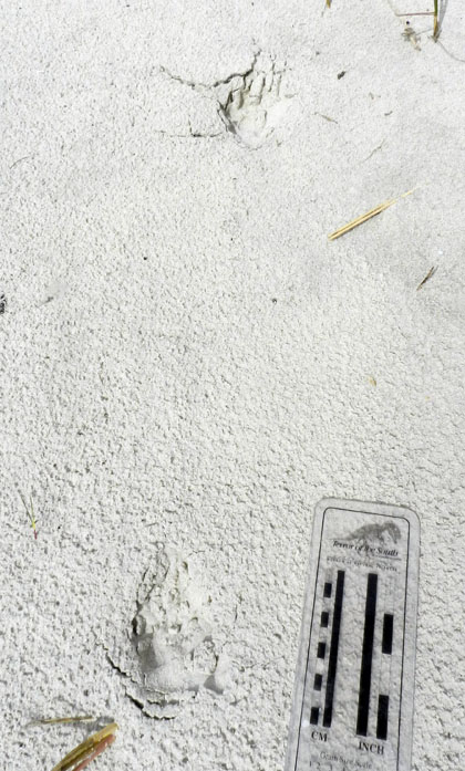
Coyote tracks – Coyotes (Canis latrans) used to be rare tracemakers on the Georgia barrier islands, but apparently have made it onto nearly all of the islands in just the past ten years or so. On Cumberland, despite its high numbers of visitors, people almost never see these wild canines. This means we have to rely on their tracks, scat, and other sign to discern their presence, where they’re going, and what they’re doing. I saw these coyote tracks while walking with my students along a trail between the coastal dunes, and they made for good in-the-field lessons on “What was this animal?” and “What was it doing?” Because Cumberland is designated as a National Seashore and thus is under the jurisdiction of the U.S. National Park Service, I’m  interested in watching how they’ll handle the apparent self-introduction of this “new” predator to island ecosystems, which may begin competing with the bobcats (Lynx rufus) there for the same food resources.

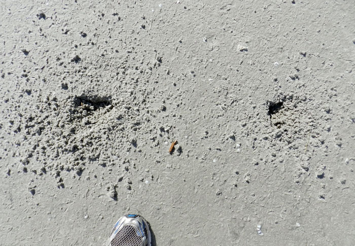
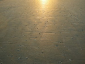
Ghost Shrimp Burrows, Pellets and Buried Whelk – Sometimes the traces on the beaches at low tide are subtle in what they tell us, and the traces in this photo qualify as ones that could be easily overlooked. The three little holes in the photo are the tops of ghost shrimp burrows. Scattered about on the beach surface are fecal pellets made by the same animals; ghost shrimp are responsible for most of the mud deposition on the sandy beaches of Georgia. The triangular “trap door” in the middle of the photo is from a knobbed whelk (Busycon carica), which has buried itself directly under the sand surface. The ghost shrimp are perhaps as deep as 1-2 meters (3.3-6.6 ft) below the surface, and are feeding on organics in their subterranean homes. These homes are complex, branching burrow systems, reinforced by pelleted walls. Hence these animals and their traces provide a study in contrasts of adaptations, tiering, and fossilization potential. The whelk trace is ephemeral, and could be wiped out with the next high tide, especially if the waiting whelk emerges and its shallow burrow collapses behind it. On the other hand, only the top parts of the ghost shrimp burrows are susceptible to erosion, meaning their lower parts are much more likely to win in the fossilization sweepstakes.
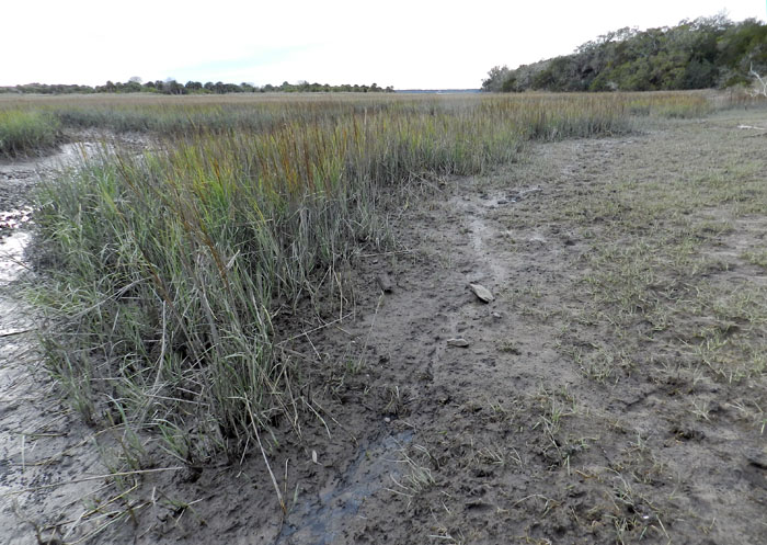
Feral Horse Grazing and Trampling Traces – Probably the most controversial subject related to any so-called “wild” Georgia barrier islands is the feral horses of Cumberland Island, and what to do about their impacts on island ecosystems there. A year ago, I wrote a post about these tracemakers as invasive species, and discussed this same topic with students before we visited in February. But nothing said “impact” better to these students than this view of a salt marsh, overgrazed and trampled along its edges by horses. This is a example of how the cumulative effects of traces made by a single invasive species can dramatically alter an ecosystem, rendering it a less complete version of its original self.

St. Catherines Island
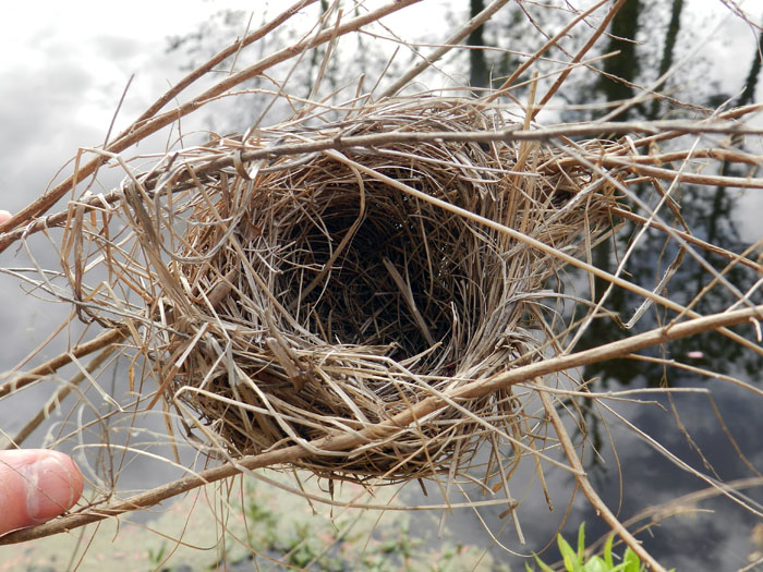
Suspended Bird Nest – I don’t know what species of bird made this exquisitely woven and suspended little nest, but I imagine it is was a wren, and one related to the long-billed marsh wren (Telmatodytes palustris), which also makes suspended nests in the salt marshes. This nest was next to one of several artificial ponds with islands constructed on St. Catherines with the intent of helping larger birds, such as egrets, herons, and wood storks, so that they can use the islands as rookeries. These ponds are also inhabited by alligators, which had left plenty of tracks, tail dragmarks, and other sign along the banks. With virtually no chance of being preserved in the fossil record, this nest was a humbling reminder of what we still don’t know from ichnology, such as when this specialized type of nest building evolved, or whether this behavior happened first in arboreal non-avian dinosaurs or birds.
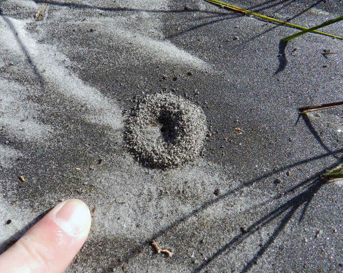
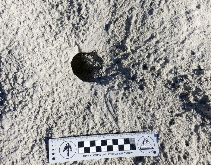
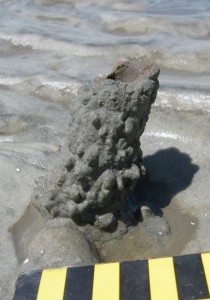
Ant Nest in Storm-Washover Deposit – As you can see, the aperture of this ant nest, as well as the small pile of sand outside of it, did not exactly scream out for attention and demand that its picture be taken. But its location was significant, in that it was on a freshly made storm-washover deposit next to the beach. This “starter nest” gives a glimpse of how ants and other terrestrial insects can quickly colonize sediments dumped by marine processes, such as storm waves. These sometimes-thick storm deposits can cause locally elevated areas above what used to be muddy salt marshes. This means insects and other animals that normally would never burrow into or traverse these marshes move into the neighborhood and set up shop, blissfully unaware that the sediments of a recently buried marginal-marine environment are below them. Ant nests also have the potential to reach deep down to those marine sediments, causing a disjunctive mixing of the traces of marine and terrestrial animals that would surely confuse most geologists looking at similar deposits in the geologic record.
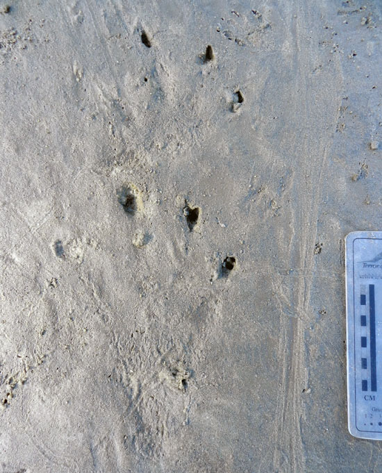
Alligator Tracks in a Salt Marsh – These alligator tracks, which are of the left-side front and rear feet, along with a tail dragmark (right) surprised me for several reasons. One was their size: the rear foot (pes) was about 20 cm (8 in) long, one of the largest I’ve seen on any of the islands. (As my Australian friends might say, it was bloody huge, mate.) This trackway also was unusual because it was on a salt pan, a sandy part of a marsh that lacks vegetation because of its high concentration of salt in its sediments. (According to conventional wisdom, alligators prefer fresh-water environments, not salt marshes.) Yet another oddity was the preservation of scale impressions in the footprints, which I normally only see in firm mud. Finally, the trackway was crosscut by trails of grazing snails and burrows of sand-fiddler crabs (Uca pugilator). This helped me to age the tracks – probably less than 24 hours old, and not so fresh that I should have reason to get worried. (Although I did pay closer attention to my surroundings after finding them.) Overall, this also made for a neat assemblage of vertebrate and invertebrate traces, one I would be delighted to find in the fossil record from the Mesozoic Era.

Jekyll Island
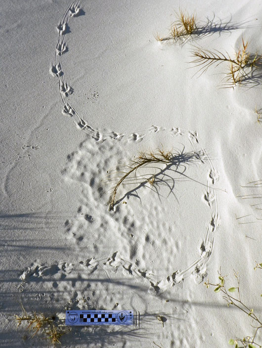
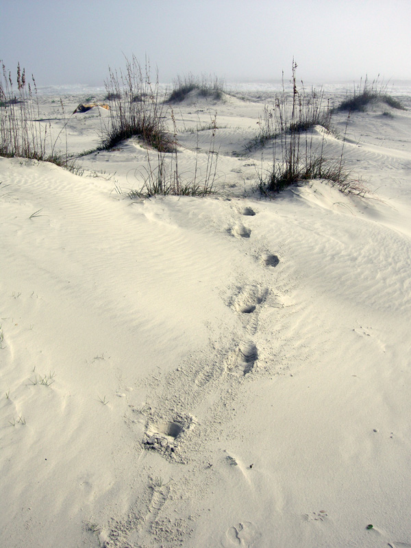
Grackle Tracks and Obstacle Avoidance – These tracks from a boat-tailed grackle (Quiscalus major), spotted just after sunrise on a coastal dune of Jekyll Island, are beautifully expressed, but also tell a little story, and one we might not understand unless we put ourselves down on its level. Why did it jog slightly to the right and then meander to the left, before curving off to the right again? I suspect it was because the small strands of bitter panic grass (Panicum amarum), sticking up out of the dune sand, got in its way. Similar to how we might avoid small saplings while walking through an otherwise open area, this grackle chose the path of least resistance, which involved walking around these obstacles, rather than following a straight line. If we didn’t know about this from such modern examples, but we found a fossil bird trackway like this but didn’t look for nearby root traces, how else might we interpret it?
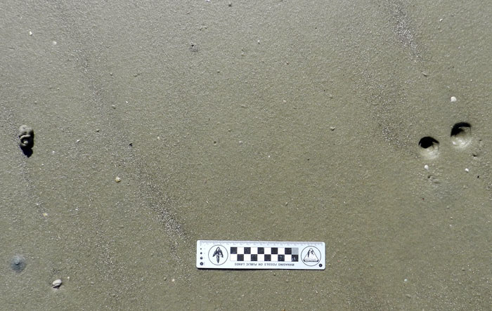
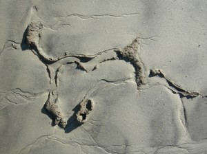
Acorn Worm Burrow, Funnels and Pile – When I came across the top of this acorn-worm burrow, which was probably from the golden acorn worm (Balanoglossus aurantiactus), and on a beach at the north end of Jekyll, I realized I was looking at a two-dimensional expression of a three-dimensional structure. Acorn worms make deep and wide U-shaped vertical burrows, in which they quite sensibly place their mouth at one end and their anus at the other. These burrows usually have a small funnel at the top of one arm of the “U,” which is the “mouth end.” The “anus end” is denoted by a pile of what looks like soft-serve ice cream, which it most assuredly is not, as this is its fecal casting, squirted out of the burrow. What was interesting about this burrow is the nearby presence of a second funnel. This signifies that the worm shifted its mouth end laterally by adding a new burrow shaft to the previous one, superimposing a little “Y” to that part of the U-shaped burrow.
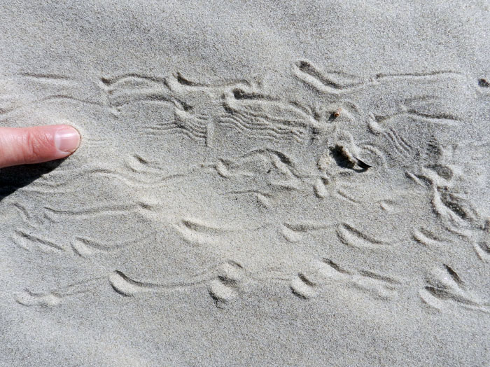
Ghost Crab Dragging Its Claw – As ubiquitous and prolific tracemakers in coastal dunes of the Georgia barrier islands, and as many times as I have studied their traces, I can always depend on ghost crabs (Ocypode quadrata) to leave me signs telling of some nuanced variations in their behavior. In this instance, I saw the finely sculpted, parallel, wavy grooves toward the upper middle of its trackway, made while the crab walked sideways from left to right. A count of the leg impressions in the trackway yielded “eight,” which is the number of its walking legs. This means the fine grooves could only come from some appendage other than its walking legs: namely, one of its claws. Why was it dragging its claw? I like to think that it might have been doing something really cool, like acoustical signaling, but it also might have just been a little tired, having spent too much time outside of its burrow.

So now you know a little more about who left their marks on the Georgia barrier islands in 2012. What will 2013 bring? Let’s find out, with open eyes and minds.

 

Different Coastlines, Same Traces, and Time

This past week, I visited North Carolina for varied reasons, but all related to paleontology and geology. First, I gave a well-attended evening lecture about polar dinosaurs, graciously invited and hosted by the Department of Geography and Geology at the University of North Carolina-Wilmington (UNCW). Later in the week, I presented a poster at the Society of Vertebrate Paleontology (SVP) meeting in Raleigh (covered last week here), while also taking in a couple of days of talks, posters, and enjoyably catching up with paleo-friends while meeting neo-friends. Regrettably, I had to leave the meeting early, but with good reason, which was for a field trip to look at fossils in a Pleistocene outcrop near Wilmington with faculty and students from UNCW. Overall, it was a fulfilling week, teeming with paleontological and social variety.
This pithy summary, though, omits lots of details (and if it didn’t, then it wouldn’t be pithy). But one item worth explaining a bit more here was a brief trip to Wrightsville Beach, which is a barrier island was just east of Wilmington. Dr. Doug Gamble, a geography professor in the UNCW Department of Geography and Geology, offered to take me there just before my talk, which I eagerly accepted. Considering all of the field work I had done on the Georgia barrier islands to the south of there, and that I would be teaching a course on barrier islands next semester, going to this beach was an opportunity to learn more about the similarities and differences between Georgia and North Carolina beaches.

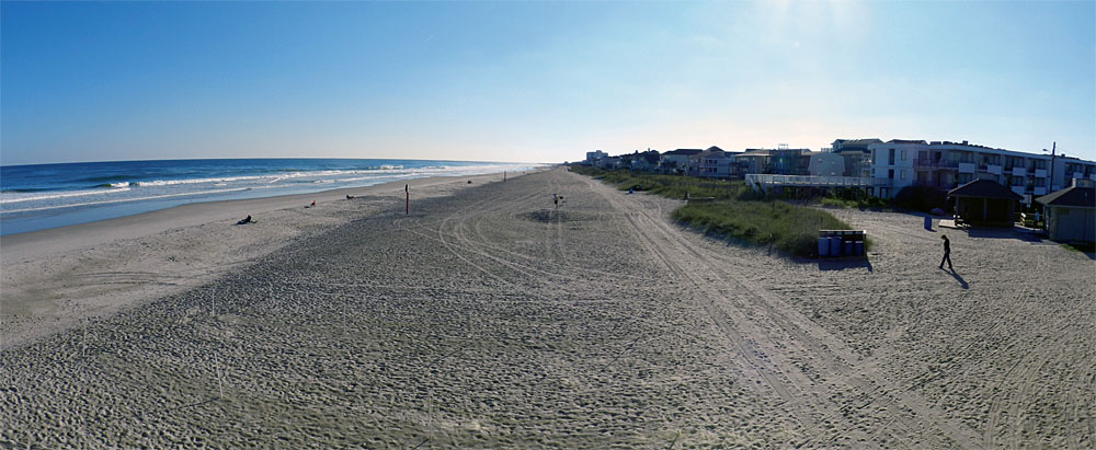
Panorama of Wrightsville Beach on the coast of North Carolina, replete with human locomotion traces and dwelling structures. These features make it very different from most beaches in Georgia. But what about other traces? Don’t you just love rhetorical questions? Including this one? (Photograph by Anthony Martin.)

Many North Carolina beaches are famous (or infamous) as examples of what can go wrong with unrestrained development of barrier islands. Many such case studies have been explored through the research, writings, and activism of geologist Dr. Orrin Pilkey of Duke University, as well as other coastal geologists who have looked at the effects of human alterations of these habitats. Wrightsville Beach is such a barrier-island beach, having  been heavily modified by human activities during the past 150 years or so. When comparing it in my mind to the Georgia barrier islands, it most resembled Tybee Island, which is also next to a relatively large city (Savannah), easily accessible by a bridge, and developed as a sort of “vacation destination” for people who like beaches, but also want them to have all of the amenities of the places they left behind. Otherwise, it held little resemblance to the mostly uninhabited and undeveloped beaches I prefer to peruse on the Georgia barrier islands.
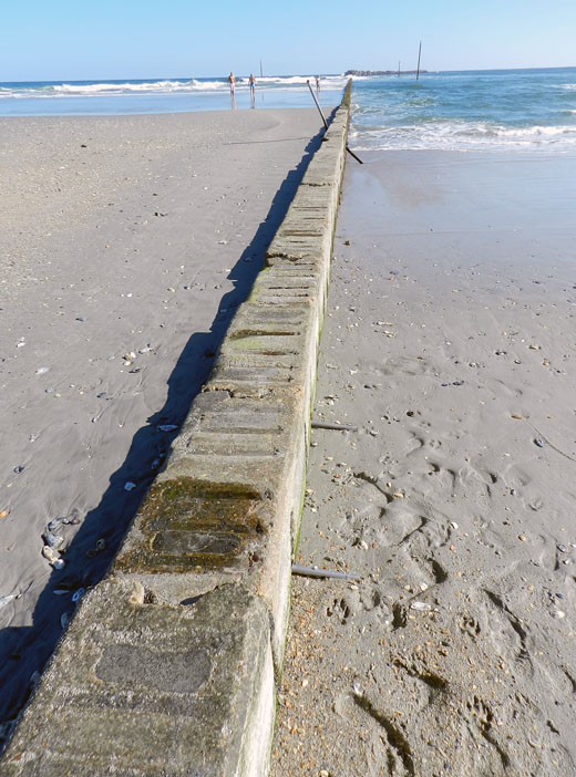
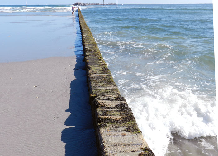
After driving over the bridge to the island, we walked onto the beach in several places, and I began looking for traces. At first there was little to see, which was a direct result of there being too much to see. Because it was a pleasant day and we were visiting in the afternoon, much of the beach had been heavily trampled by humans, with more than a few of these people aided in their bioturbation by canine companions. Obvious restructuring of the beach included a jetty at the north end that combined a concrete wall and boulders, and pilings of concrete blocks at the south end. Dunes were modest, low-profile, and capped by sparse stands of sea oats (Uniola paniculata), and behind these were hotels, condominiums, and houses, all chock-a-block. It would be too strong to say this beach was alien to me, let alone post-apocalyptic, but it did seem like an altered reality compared to my experiences in Georgia.

A jetty at Wrightsville Beach (North Carolina) composed of concrete and rocks, intended to preserve sand on the beach, which it is doing here, but also results in an imbalanced distribution of sand along it. Note the abundant human and canine tracks on the right, shouting out any other animal traces that might have been in the sand. (Photograph by Anthony Martin.)

Another view of the jetty at Wrightsville Beach, sharply contrasting sand deposition and erosion on either side of it. (Photograph by Anthony Martin.)

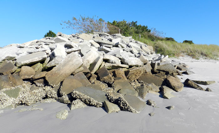
A pile of broken concrete being used as rip-rap at the south end of Wrightsville Beach in an attempt to slow erosion there. Or something. (Photograph by Anthony Martin.)

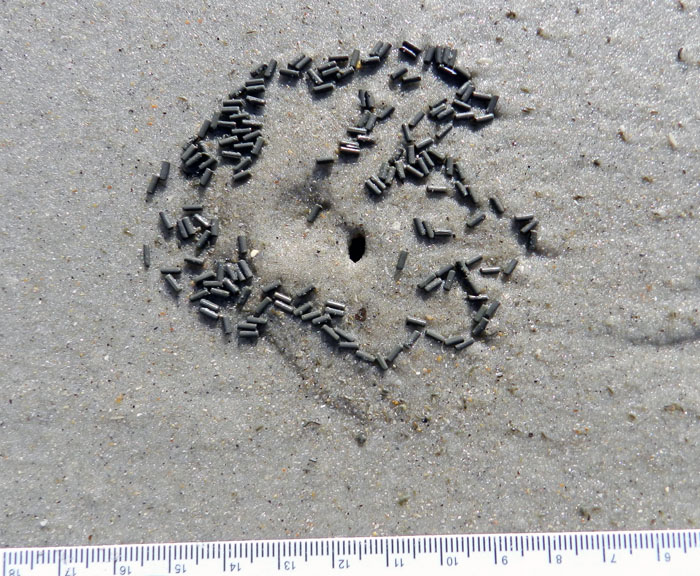
Only with more walking toward the south end of the beach did we see less of an overwhelming human-dog ichnoassemblage and start noticing signs of the native fauna. With this, I became comforted by the familiar. These traces included some I had seen many times on Georgia beaches, including: the soda-straw-like burrows of parchment worms (Onuphis microcephala); the volcano-like sand mounds and chocolate-sprinkle-like feces of callianassid shrimp (either Biffarius biformis and Callichirus major); the soft-serve-ice-cream-like fecal mound of acorn worms (Balanoglossus aurantiactus); and the hole-in-the-ground-like burrows of ghost crabs (Ocypode quadrata). (OK, so I ran out of metaphors.) Seagull tracks abounded as well, lending more of a dinosaurian flavor to the trace assemblage.

Two burrows of parchment worms (Onuphis microcephala) on Wrightsville Beach, exposed by a little bit of erosion, with tiny fecal pellets at their bases. Scale in millimeters. (Photograph by Anthony Martin.)

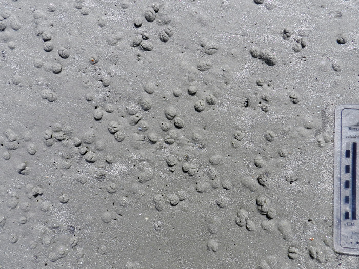
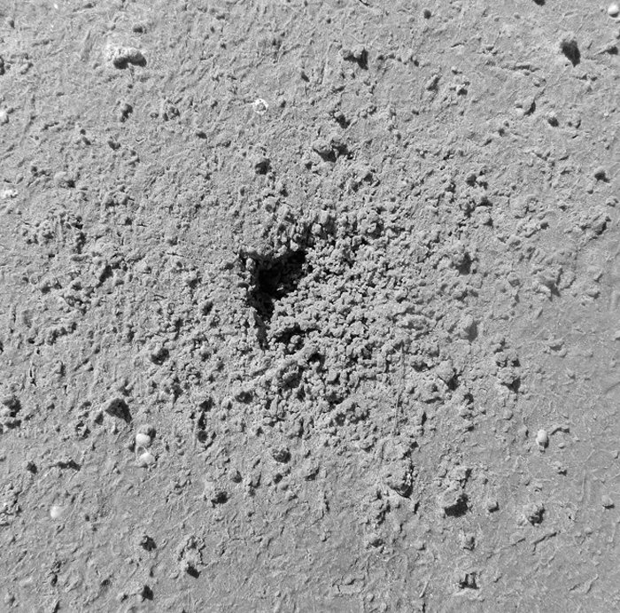
Burrow aperture and fecal pellets of a ghost shrimp (either Biffarius biformis or Callichirus major) on Wrightsville Beach. Scale in millimeters again. (Photograph by Anthony Martin.)

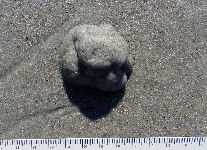
Fecal casting of an acorn worm, and probably that of a golden acorn worm (Balanoglossus aurantiactus) on Wriightsville Beach. One end of its burrow is underneath this pile, and that would be its anal end, which is sensibly located in a different place from its oral end. And I think you know the scale by now. (Photograph by Anthony Martin.)

Ghost crab (Ocypode quadrata) burrow and tracks, out of the intertidal zone and more into the dunes on Wrightsville Beach. (Photograph by Anthony Martin.)

These traces thus showed us that this North Carolina beach, one majorly changed by humankind during the past 150 years, actually was more biodiverse than one might think at first glance. In my mind, then, it became just a bit more wild through these signs of life hinting at what laid beneath our feet.

At this point, I could depress everyone by listing what traces and biota were not there, but that’s not the point, so I won’t. In a more progressive sense, what traces we saw represented traces of hope, of life hanging on despite environmental change, living almost invisibly beneath our feet. So as human development continues on beaches like these, and sea level rises through the rest of this century, I felt assured of their being survivors of this change, and of their traces outlasting our humanity. The trace fossils of the future are now, and recording our effects on the life that makes these traces. How many will wink out with our species, and how many of their marks will outlast us?

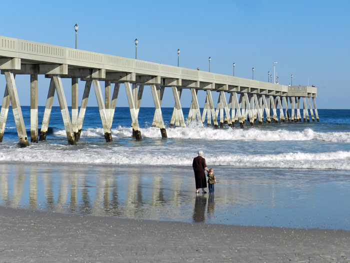
An intergenerational stroll – a grandmother and grandson? – alongside the pier on Wrightsville Beach in North Carolina. Did she have memories of this beach in her childhood? How do these compare to what she sees there now? What memories will this child have of it in the future, especially as the sea continues to rise? If these memories are not recorded, what will be left behind? (Photograph by Anthony Martin.)

Further Reading

Pilkey, O., and Fraser, M.E. 2005. A Celebration of the World’s Barrier Islands. Columbia University Press, New York: 309 p.

Thieler, E.R., Pilkey, O., Cleary, W.J., and Schwab, W.C. 2001. Modern sedimentation on the shoreface and inner continental shelf at Wrightsville Beach, North Carolina, U.S.A. Journal of Sedimentary Research, 71: 958-970.

Coquina Clams, Listening to and Riding the Waves

A little more than a week ago, I co-led a class field trip to Cumberland Island, Georgia and the nearby Okefenokee Swamp for a course titled Ecosystems of the Southeastern U.S. Although I had been to both places more than a few times, none of the students – and a few of my colleagues – had never visited either, potentially casting these already special places in a more exciting light for them.

Nonetheless, as is typical with any field trip to a Georgia barrier island, I also noticed new phenomena while on Cumberland, once again demonstrating how field trips with students ideally also cause the instructors to be filled with wide-eyed wonder. Even better, a few seemingly lowly small bivalves – coquina clams (Donax variabilis) – provided the intellectual highlight for me while we were on Cumberland Island. This is saying something for an island bearing charismatic livestock as a touristic draw.

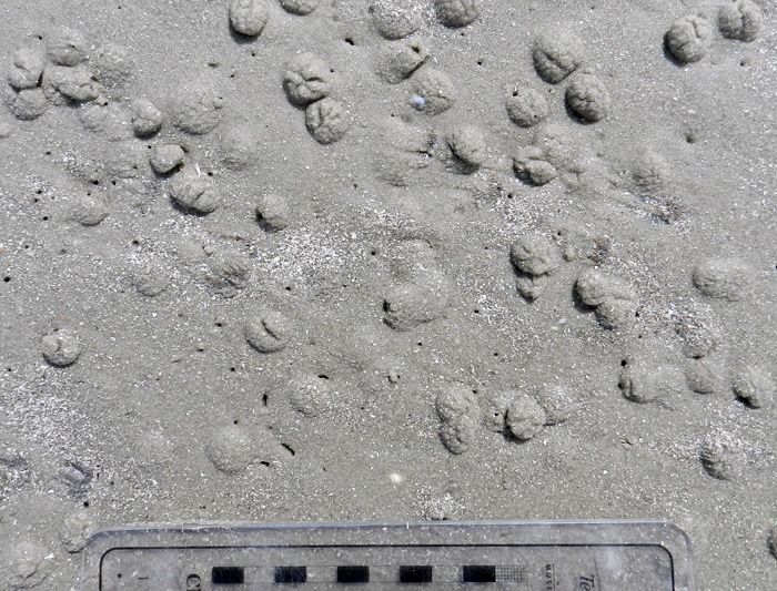
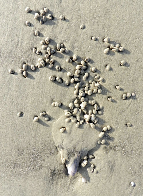
Resting traces (or are they escape traces?) of coquina clams (Donax variabilis) in the upper intertidal zone of a beach on Cumberland Island, Georgia. These clams are buried just underneath each bump of sand, but some others are much deeper and safer. How do I know that? You’ll find out. (Photograph by Anthony Martin.)

We first noticed the clams as a death assemblage just above the uppermost part of the surf zone on the beach. Their shells, some evident as single valves and others as pairs still hinged together, had been deposited by waves following a high tide, then moved slightly by the wind. These finely ribbed and polished shells readily showed why the specific name of coquina clams (D. variabilis) is applied to them, as they display a gorgeous variety of colors: yellow, orange, beige, blue, pink, and other schemes that surely would inspire interior decorators seeking paisley themes.

Coquina clams with both valves intact or apart, some partially covered by windblown sand, and variably colored. (Photo by Anthony Martin, taken on Cumberland Island, Georgia.)

Just a little bit lower on the beach and in the freshly scoured intertidal zone, we then noticed many small bumps of sand. Underneath these bumps were living clams that buried themselves, which helps to avoid drying out between tides or predation by ravenous shorebirds. With regard to the latter, these bivalves still would have been easy targets for shorebirds intent on acquiring some fresh clam snacks: think of a person ducking under a blanket to avoid being eaten by a lion and how well that might work as a tactic. (Please, just think about it and don’t actually test this idea.)

However, instead of simply writing off all coquina clams as inept burrowers who deserve to die at the beaks of their avian overlords – a similar fate experienced by dwarf surf clams (Mulinia lateralis) – we should look well below the surface, and I mean the sand surface. Look again at the photo first shown above. See all of those tiny, paired holes in between the bumps? Those are the traces of siphons from more deeply buried coquina clams, which are much more likely to escape from bivalve-munching birds while also keeping moist until the next high tide.

Here’s the same photo as above, but zoomed in so you can see the details. Did you notice all of the little holes in between shallowly buried clams? If so, bravo. If not, oh well. (Despite the cropping, turning, and otherwise shuffling electrons, this photograph is still by Anthony Martin, and was still taken on Cumberland Island.)

Coquina clams are actually accomplished burrowers, a necessary adaptation for nearly any small animal living in the high-energy surf of a Georgia beach. In the event of a wave breaking on a beach and washing away the top layer of sand, thus exposing a coquina clam, it will open its valves only enough to stick out its foot, which it then vibrates rapidly. This movement loosens the wet sand underneath, and the clam’s smooth, streamlined shell does the rest of the job, allowing it to glide into its self-made local pit of quicksand and vanish from the surface.

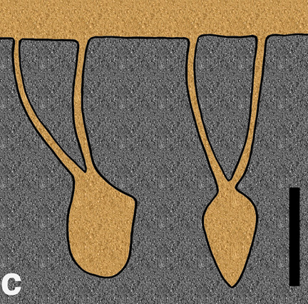
Once under the sand, this clam remains in a vertical position and projects its siphons upwards, making paired holes visible at the sand surface. The resulting burrow is Y-shaped, with the clam body making the lower part of the “Y” and the two siphons leaving thinner traces above. On the Cumberland Island beach the given day we observed their traces, I suspect the more deeply buried clams had the benefit of wetter sand early on as the tide dropped, then the ones hiding under mere caps of sand did the best they could with less wet sand later.

Vertical sections of the Y-shaped burrows made by a coquina clam, dwarf surf clam, or similar small, burrowing bivalves on the Georgia coast, in which the clam body is removed and sediment filled in the empty spaces from above. Both views, taken at right angles from one another, assume the clam is not moving up or down in the sand, which actually isn’t very realistic. (Illustration by Anthony Martin.)

How do we apply this knowledge to the fossil record? Paleontologists have found similar small, Y-shaped burrows in fine-grained sedimentary rocks, trace fossils named Polykladichnus. Some of these burrows are interpreted as the works of suspension-feeding bivalves, although polychaete worms or small arthropods are possible tracemakers, too. Where the lower parts of bivalves rested in sediment and left impressions of their lower halves, which were later filled by overlying sediments, are trace fossils called Lockeia. As a result, paleontologists can reliably identify a former presence of bivalves in rocks that might not have any of their shells. (By the way, please remember that trace fossil names are not the names of the bivalves that made the traces, but of the trace fossil itself. Yeah, I know, that’s confusing. But if you need more of an explanation, I have one for you here.)

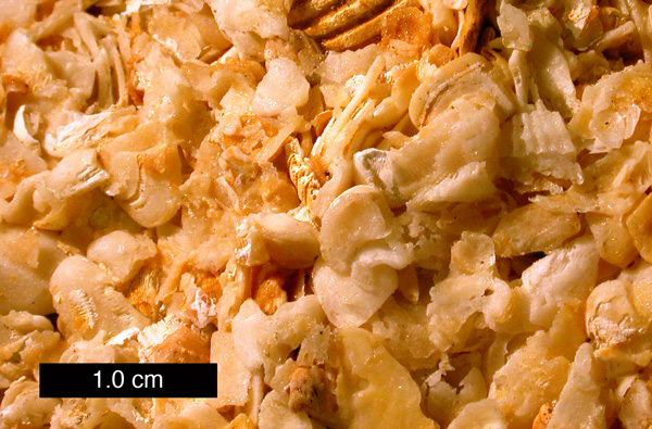
So what else is significant about coquina clams? Well, for one, their shells were abundant enough to have formed the framework for a loosely cemented limestone common in Florida, coquina limestone. This is a rock encountered by nearly anyone who has enjoyed (or suffered through) an introductory geology lab exercise on sedimentary rock identification. Students of mine have often compared these rock samples to popcorn balls or similar sugar-cemented treats, although I’ve noticed that no one has been tempted to eat them, no matter how long I kept them in lab that day.

Coquina limestone from Florida. Notice that some of the pieces are from other species of bivalves with rougher, corrugated shells, so these rocks are not made entirely of coquina clams. (Photograph by Mark Wilson of Wooster College, and taken from Wikipedia Commons here.)

But I saved the best tidbits of information for last, and something I’ll bet most people don’t know about these clams that makes them, like, totally cool. These little bivalves respond to sound and migrate seasonally. Yes, that’s right: these clams have their own form of “listening” and they can move en masse once the seasons change on the Georgia coast. Here’s how they do both:

Stop, Look, Listen – Of course, clams lack ears (although rumors still persist that they have legs). Thus they do not hear in the sense we do, but instead respond to low-frequency vibrations caused by waves striking the shore. Once these vibrations are detected, they react by: popping out of the sand; jumping up into the water; body surfing on the wave; and quickly reburying themselves in the sand once dumped by that same wave. Like some aficionados of heavy metal or punk rock, louder is better, as higher-decibel waves cause more clams to jump up out of the sand and into the water, an aquatic version of a molluscan mosh pit.

Shelled Migration – Coquina clams, like caribou, wildebeest, and arctic terns, migrate. Unlike the vast distances covered by those animals, though, coquina clams simply move up and down the slope of a beach with the changes of the seasons. Using their wave-surfing and burrowing abilities, they move from the lower intertidal zone – which is where they live during the spring, summer, and fall – to the upper part of the beach, which becomes their winter homes.

So I hope that all of this pondering over a few shells, bumps, and holes on a Cumberland Island beach has helped lend an appreciation for the small wonders on any given Georgia barrier island. Who knows what little discovery the next field trip will bring, or whether some facsimile of what is seen might also be preserved in the fossil record? As the old saying goes, time will tell, whether that time is in the present or the geologic past.

Further Reading

Ellers, O. 1995a. Discrimination among wave-generated sounds by a swash-riding clam. Biological Bulletin, 189: 128-137.

Ellers, O. 1995b. Behavioral control of swash-riding in the clam Donax variabilis. Biological Bulletin, 189: 120-127.

Pemberton, S.G., and Jones, B. 1988. Ichnology of the Pleistocene Ironshore Formation, Grand Cayman Island, British West Indies. Journal of Paleontology, 62: 495-505.

Ruppert, E.E., and Fox, R.S. 1988. Seashore Animals of the Southeast. University of South Carolina Press, Columbia, South Carolina: 429 p.

Turner, H.J., Jr., and Belding, D.L. 1957. The tidal migrations of Donax variabilis Say. Limnology and Oceanography, 2: 120-124.

Alien Invaders of the Georgia Coast

(This is the first in a series of posts about invasive species on the Georgia barrier islands, their traces, the ecological impacts of these traces, and why people should be aware of both their traces and impacts.)

Paleontologists like me face a challenge whenever we study modern environments while trying to learn how parts of these environments might translate into the geologic record. Sure, we always have to take into account taphonomy (fossil preservation), through which we acknowledge that nearly none of the living and dead bodies we see in a given environment will become fossilized; relatively few of their tracks, trails, burrows, or other traces are likely to become trace fossils, either.

Because of this pessimistic (but realistic) outlook, paleontologists often rub a big eraser onto whatever we draw from a modern ecosystem, telling ourselves what will not be there millions of years from now. We then retroactively apply this concept – a part of actualism or, more polysyllabically, uniformitarianism – to what happened thousands or millions of years ago. When paleontologists do this, they assume that today’s processes are a small window through which we can peer, giving insights into processes of the pre-human past.

Feral horse (Equus caballus) tracks crossing coastal dunes on Cumberland Island, Georgia. During their evolutionary history, horses originated in North America and populations migrated to Asia, but populations in North America went extinct during the Pleistocene Epoch about 10,000 years ago. Using the perspective of geologic time, then, could someone argue that horses are actually “native,” and these feral populations are restoring a key part of a pre-human Pleistocene landscape? (Photograph by Anthony Martin.)

However, a huge complication in our quest for actualism is this reality: nearly every ecosystem we can visit on this planet is a hybrid of native and alien species, the latter introduced – intentionally or not – by us. Thus when we watch modern species behaving in the context of their environments, we always need to always ask ourselves how non-native species have cracked the window through which we squint, through the past darkly.

This theme is considered in Charles C. Mann’s most recent book, 1493: Uncovering the New World Columbus Created, in which he argues how nearly all terrestrial ecosystems occupied by people were permanently altered by the rapid introduction of exotic species worldwide following Columbus’s landfall in the Western Hemisphere. Going even further back, though, the introduction of wild dogs (dingoes) into mainland Australia by humans about 5,000 years ago irrevocably changed the environments of an entire continent. Examples like these show that European colonization and its aftermath in human history during the last 500 years was not the sole factor in the spread of non-native species, and hints at how species invasions have been an integral part of humanity and its movement throughout the world.

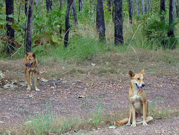
Something tells me we’re not in Georgia any more. A male-female pair of dingoes (Canis lupus dingo) pose for a picture in Kakadu National Park, Northern Territory, Australia. Although now considered “native,” dingoes are an example of an invasive species that had a huge impact once brought over by people from southeast Asia about 5,000 years ago. For one, its arrival is linked to the extinction of native carnivorous mammals in the mainland Australia, such as thylacines (Thylacinus cynocephalus) and Tasmanian devils (Sarcophilus harrisii). (Photograph by Anthony Martin.)

Well-meaning (but deluded) designations of “pristine,” “untouched,”and “unspoilt” aside, the Georgia barrier islands are no exception to alien invaders. Moreover, like many barrier-islands systems worldwide, they differ greatly from island to island in: which species of invaders are there; numbers of individuals of each species; and the degree of how these organisms impact island ecosystems and even their geological processes.

Feral cat tracks in back-dune meadows of Jekyll Island, Georgia. Jekyll is one of the few Georgia barrier islands with a significant human presence year-round, hence these cats are descended from domestic cats that were either purposefully or accidentally let loose by residents. What impact do these cats have on native species of animals and ecosystems, and are these effects comparable to those of other invasive species on other islands? Scale = 15 cm (6 in). (Photograph by Anthony Martin.)

This is one of the reasons why I devoted several pages of my upcoming book, Life Traces of the Georgia Coast, to the traces of invasive species – tracks, trails, burrows, and so on – despite their failing an “ecological purity test” for anyone who might prefer to focus on native species and their traces. With regard to invasive species, the genie is out of the bottle, so we might as well study what is there, rather than apply yet another metaphorical eraser to species that are drastically shaping modern ecosystems and affecting the behavior of native species, thus likewise altering their traces.

A large pit of disturbed sand in a back-dune meadow caused by feral hogs (Sus crofa) on St. Catherines Island, Georgia. Because feral hogs are wide-ranging omnivores with voracious appetites, they cause considerable alterations to island habitats, from maritime forests to intertidal beaches. How do these traces affect the behavior and ecology of other species, especially native ones, in such a broad range of environments on the Georgia barrier islands? Can their traces actually alter the geological character of the islands? (Photograph by Anthony Martin.)

What are some of these invasive species? What makes for an “invasive species” versus a mere “exotic species”? How do the traces of invasive species affect native species on the Georgia barrier islands, and the ecology and geology of the islands themselves? And how do paleontologists and geologists figure into the study of invasive species?

These are all questions that I hope to explore in upcoming weeks here, and for the sake of simplicity, I will showcase an invasive species of mammal and its traces each week. Some of the photos shown here serve as a visual teaser of the invasive species and their traces that will be covered: feral horses (Equus caballus), cattle (Bos taurus), hogs (Sus crofa), and cats (Felis domestica). Yes, I know, there are many others, but these four are among the most ecologically significant species, they consist of animals that nearly everyone knows, and – best of all – they make easily identifiable traces. So these fours species will provide a starting point in our learning how the Georgia barrier islands can be used as case studies in the traces and ecological effects of traces made by invasive species.

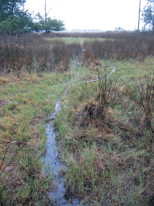
Trail made by feral cattle (Bos taurus) cutting through a salt marsh and extending to the horizon, providing a clue of how this forest-dwelling animal can travel deeply into and affect marginal-marine environments. How might such traces show up in the geologic record, and was there a species that might have made similar traces on the islands in the recent past? (Photograph by Anthony Martin.)

Shorebirds Helping Shorebirds, One Whelk at a Time

How might the traces of animal behavior influence and lead to changes in the behavior of other animals, or even help other animals? The sands and the muds of the Georgia barrier islands answer this, offering lessons in how seemingly inert tracks, trails, burrows, and other traces can sway decisions, impinging on individual lives and entire ecosystems, and encourage seemingly unlikely partnerships in those ecosystems. Along those lines, we will learn about how the traces made by laughing gulls (Larus altricilla) and knobbed whelks (Busycon carica) aided sanderlings (Calidris alba) in their search for food in the sandy beaches of Jekyll Island.

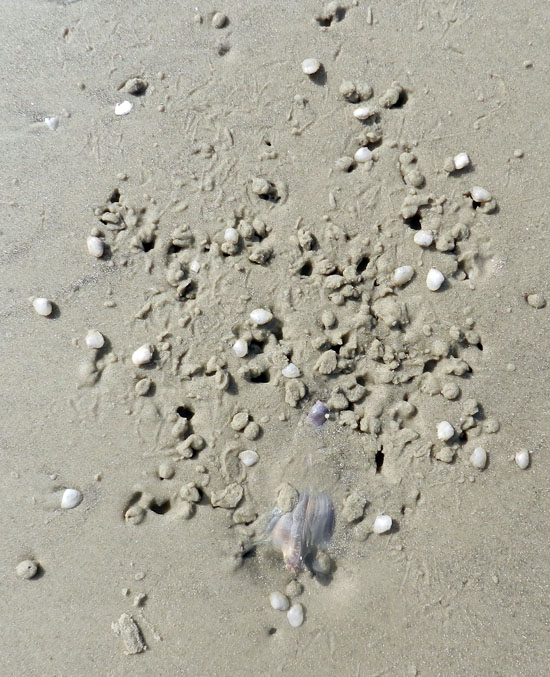
A roughly triangular depression in a beach sand on Jekyll Island, Georgia, blurred by hundreds of tracks and beak-probe marks of many small shorebirds, all of which were sanderlings (Calidris alba). What is the depression, how was it made, and how did it attract the attention of the sanderlings? Scale = size 8 ½ (men’s), which is about 15 cm (6 in) wide. (Photograph by Anthony Martin.)

Last week, we learned how knobbed whelks (Busycon carica), merely through their making trails and burrows in the sandy beaches of Jekyll Island, unwittingly led to the deaths of dwarf surf clams (Mulinia lateralis), the latter eaten by voracious sanderlings. Just to summarize, the dwarf surf clams preferentially burrowed around areas where whelks had disturbed the beach sand because the burrowing was easier. Yet instead of avoiding sanderling predation, the clustering of these clams around the whelks made it easier for these shorebirds to eat more of them in one sitting. Even better, this scenario, which was pieced together through tracks, burrows, and trails, was later verified by: catching whelks in the act of burying themselves; seeing clams burrow into the wakes of whelk trails; and watching sanderlings stop to mine these whelk-created motherlodes of molluscan goodness.

Before and after photos, showing how the burrowing of a knobbed whelk caused dwarf surf clams to burrow in the same small area (top), which in turn provided a feast for sanderlings (bottom); the latter is evident from the numerous tracks, peak-probe marks, and clam-shaped holes marking where these hapless bivalves formerly resided. (Both photographs by Anthony Martin, taken on Jekyll Island, Georgia.)

Was this the only trace-enhanced form of predation taking place on that beach? By no means, and it wasn’t even the only one involving whelks and their traces, as well as sanderlings getting a good meal from someone else’s traces. This is where a new character – the laughing gull (Larus altricilla) – and a cast of thousands represented by the small crustaceans – mostly amphipods – enter the picture. How these all come together through the life habits and traces these animals leave behind is yet another example of how the Georgia coast offers lessons in how the products of behavior are just as important as the behavior itself.

Considering that knobbed whelks are among the largest marine gastropods in the eastern U.S., it only makes sense that some larger animal would want to eat one whenever it washes up onto a beach. For example, seagulls, which don’t need much encouragement to eat anything, have knobbed whelks on their lengthy menus.

So when a gull flying over a beach sees a whelk doing a poor job of playing “hide-and-seek” during low tide, it will land, walk up to the whelk, and pull it out of its resting spot. From there, the gull will either consume the whelk on the spot, fly away with it to eat elsewhere (“take-out”), or reject it, leaving it high and dry next to its resting trace. An additional trace caused by gull predation might be formed when gulls carry the whelk through the air, drop them onto hard surfaces – such as a firmly packed beach sand – which effectively cracks open their shells and reveals their yummy interiors.

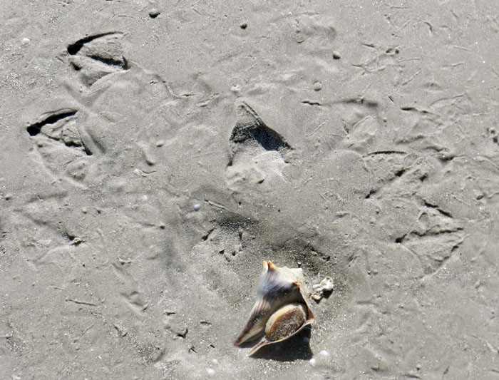
Paired gull tracks in front of a knobbed whelk resting trace, with the whelk tracemaker at the bottom of the photo. Based on size and form, these tracks were made by laughing gulls (Larus altricilla). The one on the left is likely the one that plucked the whelk from its resting trace, as its feet were perfectly positioned to pick up the narrow end of the whelk with its beak. The second gull might have seen what the first was doing and arrived on the scene soon afterwards, hoping to steal this potential meal for itself. For some reason, though, neither one ate it; instead, they discarded their object of desire there on the sandflat. For those of you who wondered if I then just walked away after taking the photo, I assure you that I threw the whelk back into water. At the same time, though, I acknowledged that the same sort of predation and rejection might happen again to that whelk with the next tidal cycle. Other shorebird tracks in the photo are from willets and sanderlings. (Photograph by Anthony Martin, taken on Jekyll Island.)

Sure enough, on the same Jekyll Island beach where we saw the whelk-surf clam-sanderling interactions mentioned last week, and on the same day, my wife Ruth Schowalter and I noticed impressions where whelks had incompletely buried themselves at low tide, only to be pried out by laughing gulls. Although we did not actually witness gulls doing performing, we knew it had happened because their paired tracks were in front of triangular depressions, followed by more tracks with an occasional discarded (but still live) whelk bearing the same dimensions as the impression.

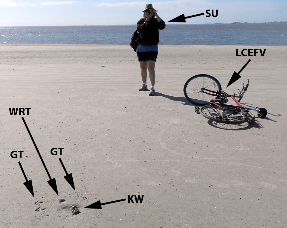
My wife Ruth aptly demonstrates how to document seagull and whelk traces (foreground) while on bicycle, no easy feat for anyone, but a cinch for her.  Labels are: GT = gull tracks; WRT = whelk resting trace; KW = knobbed whelk; SU = spousal unit; and LCEFV = low-carbon-emission field vehicle. (Photograph by Anthony Martin, taken on Jekyll Island, Georgia.)

With this search image of a whelk resting trace in mind, we then figured out what had happened in a few places when we saw much more vaguely defined triangular impressions. These were also whelk resting traces, but they were nearly obliterated by sanderling tracks and beak marks; there was no sign of gulls having been there, nor any whelk bodies. Hence these must have been instances of where the gulls flew away with their successfully acquired whelks to drop them and eat them somewhere else. But why did the sanderlings follow the gulls with the shorebird equivalent of having a big party in a small place?

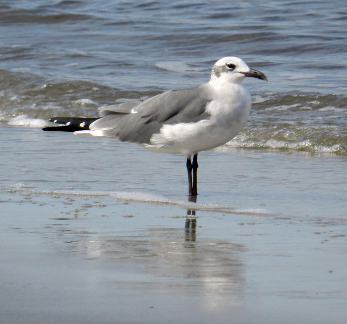
Yeah, I did it: so what? A laughing gull, looking utterly guiltless, stands casually on a Jekyll Island beach, unaware of how its going after knobbed whelks also might be helping its little sanderling cousins find amphipods. (Photograph by Anthony Martin.)

Although many people may not know this, when they walk hand-in-hand along a sandy Georgia beach, a shorebird smorgasbord lies under their feet in the form of small bivalves and crustaceans. The latter are mostly amphipods (“sand fleas”), which through sheer number of individuals can compose nearly 95% of the animals living in Georgia beach sands. Amphipods normally spend their time burrowing through beach sands and eating algae between sand grains or on their surfaces.

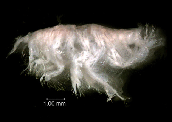
Close-up view of the amphipod Acanthohaustorius millsi, one of about six species of amphipods and billions of individuals living in the beach sands of the Georgia barrier islands, all of which are practically begging small shorebirds to eat them. Photo from here, borrowed from NOAA (National Oceanic and Atmospheric Administration – a very good use of U.S. taxpayer money, thank you very much) and linked to a site about Gray’s Reef National Marine Sanctuary, which is about 30 km (18 mi) east of Sapelo Island, Georgia.

Because amphipods are exceedingly abundant and just below the beach surface, they represent a rich source of protein for small shorebirds. But if you really want to make it easier for these shorebirds to get at this food, just kick your feet as you walk down the beach. This will expose these crustaceans to see the light of day, and the shorebirds will snap them up as these little arthropods desperately try to burrow back into the sand. This, I think, is also what happened with the gulls pulling whelks off the beach surface. Through the seemingly simple, one-on-one predator-prey act of a gull picking up a whelk, it exposed enough amphipods to attract sanderlings, which then set off a predator-prey interaction between the sanderlings and amphipods, all centered on the resting trace of the whelk.

Two whelks near one another resulted in two resting traces, and now both are missing, which likely means they were taken by laughing gulls. Notice how all of the sanderling trampling and beak marks have erased any evidence of the gulls having been there. (Photograph by Anthony Martin, taken on Jekyll Island.)

So as a paleontologist, I always ask myself, how would this look if I found something similar in the fossil record, and how would I interpret it? What I might see would be a dense accumulation of small, overlapping three-toed tracks – with only a few clearly defined – and an otherwise irregular surface riddled by shallow holes. The triangular depression marking the former position by a large snail, obscured by hundreds of tracks and beak marks, might stay unnoticed, or if seen, could be disregarded as an errant scour mark. The large gull tracks would be gone, overprinted by the many tracks and beak marks of the smaller birds.

Take a look again at the scene shown in the first photograph, and imagine it fossilized. Could you piece together the entire story of what happened, even with what you now know from the modern examples? I’m sure that I couldn’t. Scale bar = 15 cm (6 in). (Photograph by Anthony Martin.)

Hence the role of the instigator for this chain of events, the gull or its paleontological doppelganger, as well as its large prey item, would remain both unknown and unknowable. It’s a humbling thought, and exemplary of how geologist or paleontologist should stop to wonder how much they are missing when they recreate ancient worlds from what evidence is there.

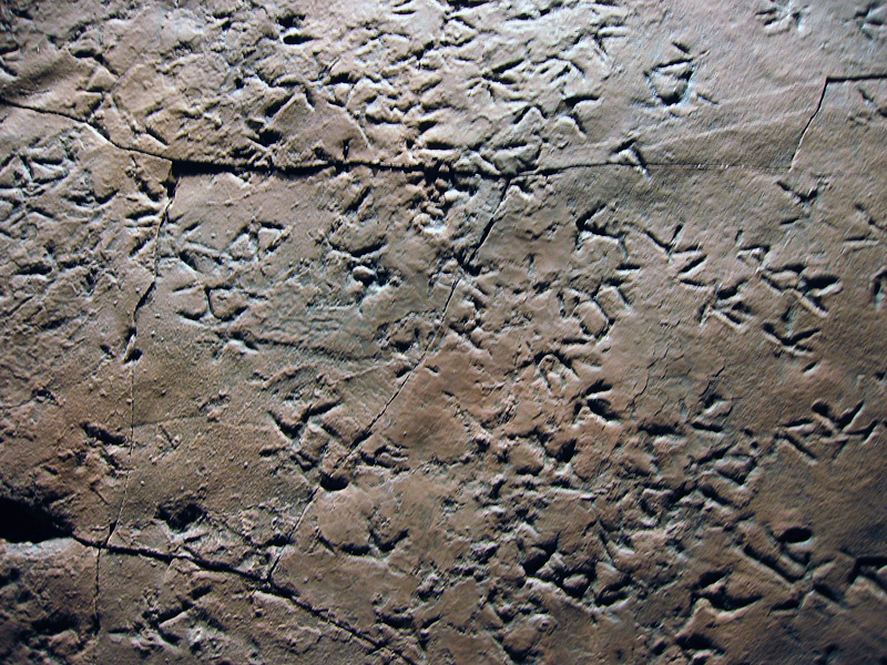
Cast (reproduction) of a dense accumulation of small shorebird-like tracks from Late Triassic-Early Jurassic rocks (about 210 million years old) of Patagonia, Argentina. These tracks are probably not from birds, but from small bird-like dinosaurs, and they were formed along a lake shoreline, rather than a seashore. Nonetheless, the tracemaker behaviors may have been similar to those of modern shorebirds. Why were these animals there, and what were they eating? Can we ever know for sure about what other animals preceded them on this small patch of land, what these predecessors eating, and how their traces might have influenced the behavior of the trackmakers? (Photograph by Anthony Martin; cast on display at Museo de Paleontológica, Trelew, Argentina.)

Another parting lesson that came out of these bits of ichnological musings is that all of the observations and ideas in this week’s and last week’s posts blossomed from one morning’s bicycle ride on a Georgia-coast beach. Even more noteworthy, these interpretations of natural history were made on an island that some scientists might write off as “too developed” to study, its biota and their ecological relationships somehow sullied or tainted by a constantly abundant and nearby human presence. So whenever you are on a Georgia barrier island, just take a look at the life traces around you, whether you are the only person on that island or one of thousands, and prepare to be awed.

Further Reading

Croker, R.A. 1968. Distribution and abundance of some intertidal sand beach amphipods accompanying the passage of two hurricanes. Chesapeake Science, 9: 157-162.

Elbroch, M., and Marks, E. 2001. Bird Tracks and Sign of North America. Stackpole Books. Mechanicsburg, Pennsylvania: 456 p.

Grant, J. 1981. A bioenergetic model of shorebird predation on infaunal amphipods. Oikos, 37: 53-62.

Melchor, R. N., S. de Valais, and J. F. Genise. 2002. The oldest bird-like fossil footprints. Nature, 417:936938.

Wilson, J. 2011. Common Birds of Coastal Georgia. University of Georgia Press, Athens, Georgia: 219 p.

Using Traces to Teach about Traces

This past weekend, my colleague Steve Henderson and I co-led a field trip to Sapelo Island, Georgia with 13 Emory University undergraduate students and our spouses. This trip is done biannually as a firm requirement for students taking a class of mine at Emory called Modern and Ancient Tropical Environments. This course, in turn, is a prerequisite for a 10-day field course we’ll do in December-January, ENVS 242, which appropriately has the same name as ENVS 241 except for the addition of “Field Course” at the end. That course, though, will take place on another island, albeit a very different one, San Salvador, one of the “Out Islands” of the Bahamas.

Why were we on Sapelo Island to prepare for a field course in the Bahamas? It was to fulfill several learning goals that will sound familiar to all science educators who take their students outside of a classroom for their learning. In no particular order, these are:

  • Get students to observe natural phenomena while in the field;
  • Ask good questions about what they’ve observed;
  • Learn how to properly record their observations;
  • Come up with explanations (hypotheses) for whatever questions were provoked by their field experiences; and
  • Staying safe while doing all of this, which included adjusting to whatever conditions we might encounter in the field.

Our spouses, Ruth Schowalter and Kitty Henderson, are also educators; Ruth teaches English as a Second Language (ESL) at Georgia Tech, and Kitty is a middle-school earth-science teacher in Covington, Georgia. Moreover, both have been to Sapelo Island many times, having gained a wealth of field-gained knowledge about its natural history. Hence our students were lucky to have all four of us there to introduce them to the island, and we likewise felt very fortunate to be there with such an eager group on a gorgeous fall weekend.

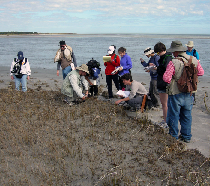
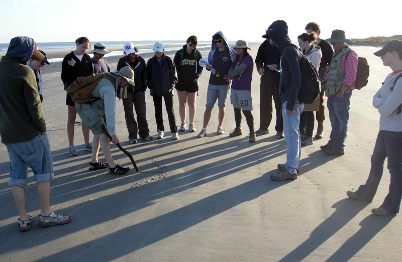
Environmental Studies students from Emory Univeristy with me (foreground) and Steve Henderson (right), looking at a 500-year-old relict salt marsh, exposed by erosion along Cabretta Beach on Sapelo Island, Georgia. Sure beats staying in a classroom to learn about modern and ancient environments. (Photograph by Ruth Schowalter.)

Of course, once on Sapelo or any other barrier island of the Georgia coast, I cannot help but use ichnology – the study of traces – as a uniting theme for my teaching. Steve, who did his Ph.D. research on Sapelo in the late 1970s, is more of a taphonomist, which is someone who studies how fossils are made, from death to burial to preservation. Nonetheless, ichnology and taphonomy overlap considerably, hence our respective approaches complement one another very well, a synergism aided by our having had the same Ph.D. advisor – Robert (Bob) Frey – at the University of Georgia. Once in the field, every track, burrow, feces, and body part of a dead animal we found – and the occasionally sighted live animal – became a dynamic learning opportunity for us, in which we could apply basic scientific methods that were all accented by a sense of wonder.

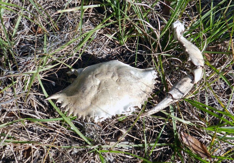
A dead blue crab (Callinectes sapidus) found in the middle of Sapelo Island, at least 2 kilometers (1.2 miles) from the ocean. How did it get there, and what happened to it? Our students went through the possibilities based on the evidence – main body nearly entire, no toothmarks on it, but bleached white and missing most legs. We finally concluded that it had been dropped by a large predatory bird, such as a great blue heron (Ardea herodias) or great egret (Ardea alba), which probably had shaken off most of the crab’s legs before attempting to eat it. A nice little lesson in taphonomy, for sure. (Photograph by Anthony Martin.)

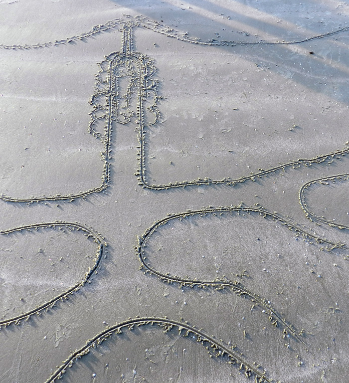
But perhaps my favorite teaching techniques to use while on Sapelo or any other Georgia barrier island is to use the completely low-tech and ancient method of drawing in the sand. Through my own traces, then, I can teach my students about ichnology and its applications to understanding geologic processes. For example, one of the beaches on Sapelo – Cabretta Beach – is undergoing rapid erosion from a combination of longshore drift and sea-level rise. At this place, downed pines and oaks laid prone in the surf, a former forest now a beach. This was the perfect place to introduce the students to Walther’s Law, which states that laterally adjacent environments will succeed one another vertically in the geologic record. This principle then can be applied to figuring out how a given sequence of strata might reflect a rising or lowering of sea level in the past.

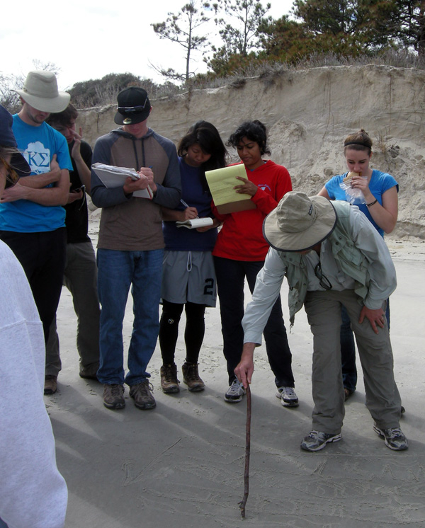
No PowerPoint? No projector? No computer? No problem. Teaching in the field is easy when you have such a nice canvas to work with. (Photograph by Ruth Schowalter.)

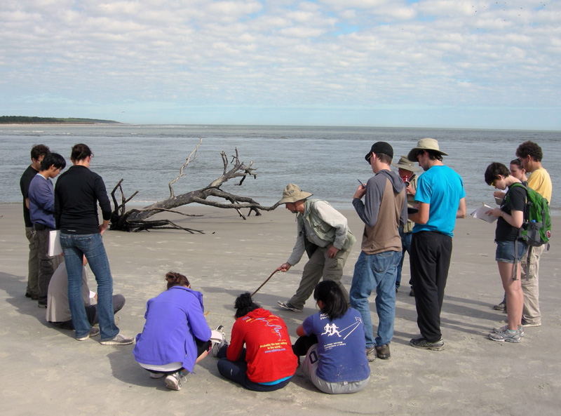
So with the sea behind me, a sandy beach wiped clean by the receding tide, and a handy stick, I scratched out a typical sequence of sedimentary strata and their diagnostic traces that would result from sea level going up (a transgression) on the Georgia coast. (Ruth and I were also inspired to create artwork on this theme, discussed in a previous entry.) Terrestrial environments with tree-root and insect traces were at the base of the sequence, succeeded vertically by sandy dune deposits with ghost-crab and insect burrows, then sandy beach deposits with ghost-shrimp burrows, topped off by offshore sandy muds and sands burrowed by fully marine echinoderms, such as heart urchins, sea stars, and brittle stars. I then asked the students to look around them and point to each of the laterally adjacent environments represented in my sand drawing, which they dutifully did. Finally, just to make sure our students got it, we inquired about what sequence should result if sea level dropped, and they correctly surmised that the place would revert back to terrestrial conditions, with the marine sediments buried below.

My applying the final touches on a sand-sketch masterpiece of a transgressive-regressive sequence of strata and its traces, as my students watch. Would you like to see it? Sorry, the tide came in just a few hours after I drew it, and we didn’t get a photo of it. So you’ll just have to draw your own, and preferably on a beautiful beach. (Photograph by Ruth Schowalter.)

As we all stood back to look at the transgressive-regressive sequence of strata, the formerly abstract concept of Walther’s Law became far more real for our students. The dead trees on either side of our group, an eroded dune and maritime forest behind us, and the sea in front of us, all reinforced this lesson, bolstered by our presence in a place with those environments being actively affected by geological and biological processes.

Another instance of using traces in the sand to teach about traces was with ghost-shrimp burrows. At low tide on the previous day of the field trip, the students found many small, volcano-like mounds on the intertidal beach surface some with neat piles of tiny mud-filled cylinders that looked like “chocolate sprinkles” sometimes seen on cupcakes. What were these?

I informed them that we were looking at the tops of ghost-shrimp burrows and their fecal pellets; earlier, we had seen the knobby, pelleted walls of these same ghost-shrimp burrows, which were the deeper parts. What does an entire ghost-shrimp burrow system look like in cross-section? Time for another sand drawing. This one introduced the students to what had been only disembodied words memorized for an exam – ghost shrimp, pellets, walls, vertical shafts, branching – that now could be supplemented by actual traces next to the drawing. You can’t beat these sorts of visual aids, a huge bonus from our being in the right places to see them.

Using a “clean slate” of a beach wiped smooth by the tide for sketching a cross-section of a typical ghost-shrimp burrow, many of which also happened to be underneath our feet. (Photograph by Ruth Schowalter.)

The final sketch of a ghost-shrimp burrow, showing its volcano-like top, narrow “chimney” leading down to the main shaft of the shrimp’s living chamber, some of the pellets lining its burrow walls, and the geometry of the burrow network below. (Photograph by Anthony Martin.)

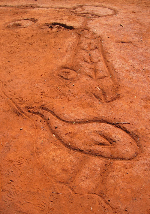
Was my teaching technique new and innovative, worth presenting at an educational conference as an assessment-friendly pedagogy that would maximize outcome-based education? In short, no. Sand drawing as a tool for education has a very long tradition in indigenous cultures, especially those that have their own forms of ichnology (such as tracking) at their cores. For example, in central Australia, Ruth and I had seen a creation story etched in the ground that had been done some by the Arrente people who live near Uluru. This story likewise used animal traces (emu tracks) as a key feature, a sort of iterative use of traces for inspiration and teaching.

Creation story of the Arrente people drawn in the soil near Uluru in Northern Territory, Australia. The figure at the bottom is an emu, and its tracks are shown leading away from it. (Photograph by Anthony Martin.)

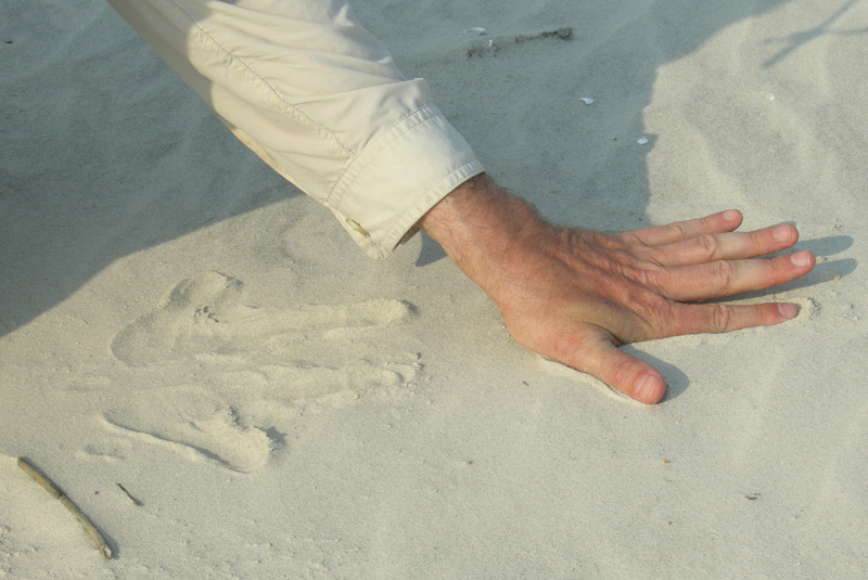
At the same place, we also watched an Arrente elder demonstrate how to make animal tracks using only his fingers and palms, which was also described in books we had read about

Did you know you can use your hands to make animal tracks? In this photo, I use the fine-grained dune sands of Sapelo Island to create a reasonable depiction of kangaroo tracks. Yes, I know, kangaroo tracks on the Georgia barrier islands are not very likely, but you get the idea. Next time I’ll do raccoon tracks instead.

Some of us educators are old enough to remember using a technological succession of blackboards and chalk, overhead projectors with pens, whiteboards with dry-erase pens, and now presentation software (Keynote, PowerPoint, and so on) for imparting lessons. So it gives me great comfort to know that, with a generation of students who have never known a world without computers with a concomitantly reduced connection to the outdoors, we can still switch back to using the ground beneath our feet, our eyes, hands, and imaginations to teach and learn about the life traces around us.

Further Reading

Bingham, J. 2005. Aboriginal Art and Culture. Raintree, Chicago, Illinois: 57 p.

Hoyt, J.H., and Hails, J.R. 1967. Pleistocene shoreline sediments in coastal Georgia: deposition and modification. Science, 155: 1541-1543.

Hoyt, J.H., Weimer, R.J., and Henry, V.J., Jr. 1964. Late Pleistocene and recent sedimentation on the central Georgia coast, U.S.A. In van Straaten, L.M.J.U. (editor), Deltaic and Shallow Marine Deposits, Developments in Sedimentology I. Elsevier, Amsterdam: 170-176.

Louv, R. 2005. Last Child in the Woods: Saving Our Children from Nature-Deficit Disorder. Algonquin Books, Chapel Hill, North Carolina: 390 p.

Middleton, G.V. 1973. Johannes Walther’s Law of the Correlation of Facies. GSA Bulletin, 84: 979-988.

Weimer, R.J., and Hoyt, J.H. 1964. Burrows of Callianassa major Say, geologic indicators of littoral and shallow neritic environments. Journal of Paleontology, 38: 761-767.

The Lost Barrier Islands of Georgia

The Georgia coast is well known for its historic role in the development of modern ecology, starting in the 1950s and ongoing today. But what about geologists? Fortunately, they were not long behind the ecologists, starting their research projects on Sapelo Island and other Georgia barrier islands in the early 1960s. Indeed, through that seminal work and investigations afterwards, these islands are now renown for the insights they bestowed on our understanding of sedimentary geology.

Why would geologists be attracted to these islands made of shifting sand and mud that were nearly devoid of anything resembling a rock? Well, before sedimentary rocks can be made, sediments are needed, and those sediments must get deposited before solidifying into rock. So these geologists were interested in learning how the modern sands and muds of the barrier islands were deposited, eroded, or otherwise moved in coastal environments, a dynamism that can be watched and studied every day along any Georgia shoreline. The products of this sediment movement were sedimentary structures, which were either from physical processes – such as wind, waves, or tides – or biological processes, such as burrowing. Hence sedimentary structures can be classified as either physical or biogenic, respectively.

Cabretta Beach on Sapelo Island at low tide, its sandflat adorned with beautiful ripples and many traces of animal life. Sand is abundant here because of a nearby tidal channel and strong ebb-tide currents that tend to deposit more sand than in other places around the island. This sand, in turn, provides lots of places for animals that live on or in the sand, making trails and burrows, demonstrating how ecology and geology intersect through ichnology, the study of traces.  Speaking of traces, what are all of those dark “pipes” sticking out of that sandy surface? Hmmm… (Photograph by Anthony Martin.)

These geologists in the 1960s were among the first people in North America to apply what they observed in modern environments to ancient sedimentary deposits, and just like the ecologists, they did this right here in Georgia. For example, in 1964, a few of these geologists – John H. Hoyt, Robert J. Weimer, and V.J. (“Jim”) Henry – used a combination of: geology, which involved looking at physical sedimentary structures and the sediments themselves; modern traces made by coastal Georgia animals; and trace fossils. Through this integrated approach, they successfully showed that the long, linear sand ridges in southeastern Georgia were actually former dunes and beaches of ancient barrier islands.

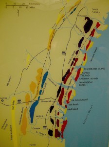
These sand ridges, barely discernible rises on a mostly flat coastal plain, are southwest-northeast trending and more-or-less parallel to the present-day shoreline. Remarkably, these ridges denote the positions of sea-level highs during the last few million years on the Georgia coastal plain. The geologists applied colorful Native American and colonial names to each of these island systems – Wicomico, Penholoway, Talbot, Pamlico, Princess Anne, and Silver Bluff – with the most inland system reflecting the highest sea level. So how did these geologists figure out that a bunch of sand hills were actually lost barrier islands? And what does this all of this have to do with traces and trace fossils?

Map showing positions of sand ridges that represent ancient barrier islands, with each ridge marking the fomer position of the seashore. The one farthest west (Wicomico) represents the highest sea level reached in the past few million years, whereas the current barrier islands reflect an overlapping of two positions of sea level, one from about 40,000 years ago (Silver Bluff), and the other happening now. (Photograph by Anthony Martin, taken of a display at the Sapelo Island Visitor Center.)

Here’s how they did it. They first observed modern traces on Georgia shorelines that were burrows made by ghost shrimp, also known by biologists as callianassid shrimp. On a sandy beach surface, the tops of these burrows look like small shield volcanoes, and a burrow occupied by a ghost shrimp will complete that allusion by “erupting” water and fecal pellets through a narrow aperture.

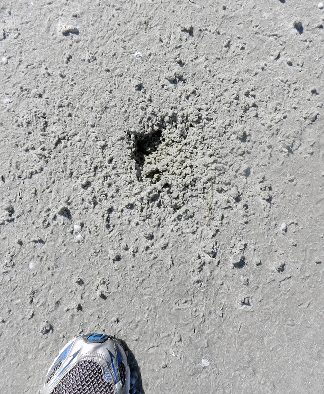
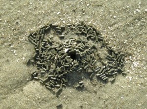
Top of a typical callianassid shrimp burrow, looking much like a little volcano and adorned by fecal pellets, which coincidentally resemble “chocolate sprinkles,” but will likely disappoint if you do a taste test. (Photograph by Anthony Martin, taken on St. Catherines Island.)

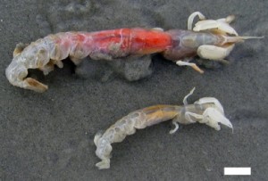
A couple of ghost shrimp, which are either a male-female pair of Carolina ghost shrimp (Callichirus major) or a Carolina ghost shrimp and a Georgia ghost shrimp (Biffarius biformis). Sorry I can’t be more accurate, but I’m an ichnologist, not a biologist (although I could easily play either role on TV). Regardless, notice they have big claws, which they use as their main “digging tools.” The tracemakers look a little displeased about being outside of their protective burrow environments, but be assured I thanked them for their contribution to science, and promptly threw them back in the water so they could burrow again. Scale = 1 cm (0.4 in) (Photograph by Anthony Martin, taken on St. Catherines Island, Georgia.)

Just below the beach surface, these interior shafts widen considerably, making these burrows look more like wine bottles than volcanoes. This widening accommodates the ghost shrimp, which moves up and down the shaft to irrigate its burrow by pumping out its unwanted feces (understandable, that) and circulating oxygenated water into the burrow. Balls of muddy sand reinforce the burrow walls like bricks in a house, stuck together by shrimp spit, and the burrow interior is lined with a smooth wall of packed mud.

A small portion of a ghost-shrimp burrow, showing its wall reinforced by rounded pellets of sand and stuck together with that field-tested and all-natural adhesive, shrimp  spit. Photograph by Anthony Martin, taken on Sapelo Island.

Amazingly, these shafts descend vertically far below the beach, as much as 2-3 meters (6.5-10 feet) deep. Here they turn horizontal, oblique, and vertical, and tunnels intersect, branch, and otherwise look like a complex tangle of piping, perhaps reminding baby-boomers of “jungle gyms” that they used to enjoy as children in a pre-litigation world. Who knows what goes on down there in such adjoining ghost-shrimp burrow complexes, away from prying human eyes?

The deeper part of a modern ghost-shrimp burrow, exposed by erosion along a shoreline and revealing the more complex horizontally oriented and branching networks. Gee, do you think these burrows might have good fossilization potential? (Photograph by Anthony Martin, taken on Sapelo Island.)

See all of those burrow entrances on this sandy beach? Now imagine them all connecting in complex networks below your feet the next time you’re walking along a beach. Feels a little different knowing that, doesn’t it? (Photograph by Anthony Martin, taken on Sapelo Island.)

Interestingly, these burrows are definitely restricted to the shallow intertidal and subtidal environments of the Georgia coast, and their openings are visible at low tide on nearly every Georgia beach. Hence if you found similar burrows in the geologic record, you could reasonably infer where you were with respect to the ancient shoreline.

I think you now know where this is going, and how the geologists figured out what geologic processes were responsible for the sand ridges on the Georgia coastal plain. Before doing field work in those area, the geologists may have already suspected that these sandhills were associated with former shorelines. So with such a hypothesis in mind, they must have been thrilled to find fossil burrows preserved in the ancient sand deposits that matched modern ghost-shrimp burrows they had seen on the Georgia coast. They also found these fossil burrows in Pleistocene-age deposits on Sapelo Island, which helped them to know where the shoreline was located about 40,000 years ago with respect to the present-day one. This is when geologists started realizing that the Georgia barrier islands were made of both Pleistocene and modern sediments as amalgams of two shorelines, and hence unlike any other known barrier islands in the world.

Vertical shaft of a modern ghost-shrimp burrow eroding out of a shoreline on Cabretta Beach, Sapelo Island. Scale in centimeters. (Photograph by Anthony Martin.)

Vertical shaft of a fossil ghost-shrimp burrow eroding out of an outcrop in what is now maritime forest on Sapelo Island, but we know used to be a shoreline because of the presence of this trace fossil. Scale in centimeters. (Photograph by Anthony Martin.)

Geology and ecology combined further later in the 1960s, when paleontologists who also were well trained in biology began looking at how organisms, such as ghost shrimp, ghost crabs, marine worms, and many other animals changed coastal sediments through their behavior. So were these scientists considered geologists, biologists, or ecologists? They were actually greater than the sum of their parts: they were ichnologists. And what they found through their studies of modern traces on the Georgia barrier islands made them even more scientifically famous, and these places became recognized worldwide as among the best for comparing modern traces with trace fossils.

Further Reading:

Hoyt, J.H., and Hails, J.R. 1967. Pleistocene shoreline sediments in coastal Georgia: deposition and modification. Science, 155: 1541-1543.

Hoyt, J.H., Weimer, R.J., and Henry, V.J., Jr. 1964. Late Pleistocene and recent sedimentation on the central Georgia coast, U.S.A. In van Straaten, L.M.J.U. (editor), Deltaic and Shallow Marine Deposits, Developments in Sedimentology I. Elsevier, Amsterdam: 170-176.

Weimer, R.J., and Hoyt, J.H. 1964. Burrows of Callianassa major Say, geologic indicators of littoral and shallow neritic environments. Journal of Paleontology, 38: 761-767.