Ghost Shrimp Whisperer

When you hear the word “shrimp,” you probably picture those that show up in grocery stores and restaurants throughout the world, which are then consumed voraciously by their terrestrial admirers. Also, some recent attention has been given to mantis shrimp, and deservedly so, because they are among the most gorgeous and terrifying of marine invertebrates today. But there are other marine crustaceans bearing the name “shrimp” that are neither gracing seafood buffets nor awesome predators, yet are worthy of our adoration, documentary films, and epic songs, the latter of which will be no doubt performed on Eurovision 2014. Yes, you guessed it: I’m talking about ghost shrimp.

Ghost-Shrimp-Burrow-Tracks-Jekyll
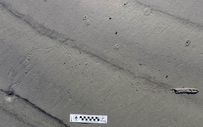
What’s this? We’re looking down on the surface of a Georgia beach at low tide. The collapsed top of a ghost shrimp burrow is in the lower left, but it’s connected to a trackway, which ends in a shallow horizontal burrow, which holds the maker of all three types of traces. Lots of other ghost-shrimp burrow tops are in the upper part of the photo, too. Life doesn’t get much better than this for an ichnologist. You may now envy me. (Photo by Anthony Martin, taken on Jekyll Island, Georgia; scale in centimeters. )

Why ghost shrimp? Because they can burrow like nobody’s business. Take a typical ghost shrimp in the Bahamas or the Caribbean, such as Glypterus acanthochirus. This crustacean is only about 10-cm (4-in) long, but if it lives for eight years and burrows continuously through that time, it will have processed a cubic meter of sediment. Individual ghost-shrimp burrows can go as deep as 5 m (16 ft). These would be like a human shoveling more than a cubic kilometer of dirt, or a vertical shaft about 100 m (330 ft) deep, but without a shovel, backhoes, augers, drilling rigs, or other tools. These vertical shafts then connect with extensive branching tunnels, making complicated networks in the sand and mud below the level of the low tide. Now multiply that industriousness by millions, and we’re talking about enormous volumes of sediment processed by ghost shrimp in their respective shallow-water environments. Ghost shrimp are like the ants of the ocean, only not as organized: no queens, workers, soldiers, or other divisions of labor, just lots of individual shrimp burrowing, eating, mating, and defecating.

Ghost-Shrimp-Burrow-Tops
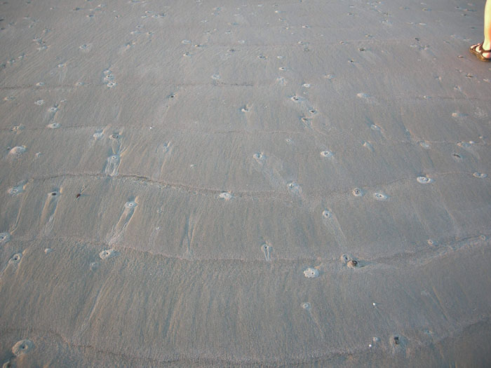
Every one of these holes is the top of an occupied ghost-shrimp burrow. Now imagine meters-long vertical shafts from each of these going down into the beach sand, then turning into branching horizontal networks of such grandeur, they would further embarrass naked moles rats, which are already apologizing for how they look. (Photo by Anthony Martin, taken on Sapelo Island, Georgia. Human foot (upper right), still attached to human, for scale.)

Ghost shrimp share a common ancestor with crabs, lobsters, crayfish, and shrimp, all of these having four pairs of walking legs and one pair of claws. (Mantis shrimp are actually not true shrimp – or even decapods – but stomatopods.) Ghost shrimp are also known by marine biologists and ichnologists as callianassid shrimp, belonging to an evolutionarily linked group (clade), Callianassidae.They burrow through sand and mud using their front two claws, but also carry sediment on their other legs. Ghost shrimp are also well-known for depositing much of the mud on Georgia beaches as elegantly packaged little cylindrical fecal pellets. These bear enough of a resemblance to “chocolate sprinkles” on cupcakes that they become tempting to sample, until you remember that they’re, like, you know, fecal.

Ghost-Shrimp-Fecal-PelletsGhost-shrimp fecal pellets, each about 5 mm long, and recently ejected by a ghost shrimp through the top of the burrow, which is the little hole just to the right. If you use them with any cupcake recipes, let me know how that worked for you. (Photo taken by Anthony Martin on St. Catherines Island, Georgia.)

Geologists love ghost shrimp, too, because of how their burrows are so numerous, fossilize easily, and are sensitive shoreline indicators. I wrote about this before with regard to how geologists in the 1960s were able to map ancient barrier islands of the Georgia coastal plain by looking for trace fossils of these burrows. Since then, geologists and paleontologists have identified and applied these sorts of trace fossils worldwide, and in rocks from the Permian Period to the Pleistocene Epoch.

I could prattle on about ghost shrimp and their ichnological incredibleness for the rest of the year, but will spare you of that, gentle reader, and instead will get to the point of this post. Just when I thought I’d learned nearly everything I needed to know about ghost-shrimp ichnology, one shrimp decided I needed to have my eyes opened to some traces I had never seen them make before just a few months ago. I mentioned these traces briefly in a previous blog post, when I was teaching undergraduate students from my barrier-islands class on Jekyll Island (Georgia) in mid-March. They were tracks and a shallow horizontal burrow made on the surface on the northernmost beach of Jekyll Island, and they were made by a ghost shrimp. How do I know they were made by a ghost shrimp? Well, maybe because they had a ghost shrimp attached to them, but that’s beside the point.

Ghost-Shrimp-Tracks-Burrow-Left-Jekyll
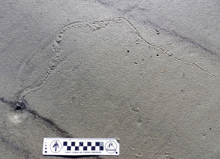
A close-up of the left side of the trackway shows more clearly how it definitely is connected to the funneled top of a burrow. The trackway shows small pointed impressions and a central groove in places, showing that this is an animal with legs and a tail, respectively. The irregular path of the trackway is a record of pauses, where the trackmaker stopped briefly before moving on. The body length of the tracemaker is subtly revealed along the way too, but explaining that would require a more advanced lesson in ichnology. So maybe another time. (Photo by Anthony Martin, taken on Jekyll Island, Georgia.)

Ghost-Shrimp-Tracks-Burrow-Right-Jekyll
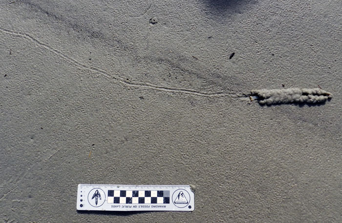
The right side of the trackway, ending in a short and shallow horizontal tunnel, just under the sandy beach surface. (Photo by Anthony Martin, taken on Jekyll Island, Georgia.)

Ghost-Shrimp-Tracks-Burrow-Closeup-JekyllThe trackway and tail-trail ends in a tunnel with a thin roof of sand. The bilobed pattern was made by the claws and other legs on either side moving sand up and around the body of the tracemaker. Notice the roof collapsed a little on the right, and that its tail is sticking out on the left: kind of like hiding under a too-short blanket. (Photo by Anthony Martin, taken on Jekyll Island, Georgia.)

Ghost-Shrimp-Jekyll
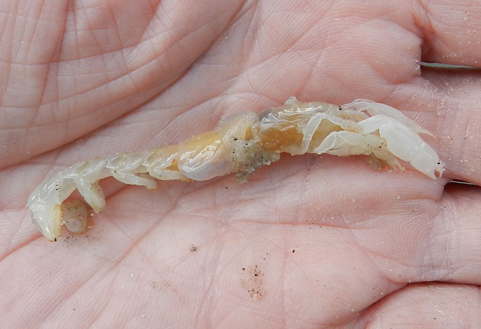
Ta-da – the tracemaker revealed! I’m fairly sure this is a Georgia ghost shrimp (Biffarius biformis), but would appreciate all of those marine biologists out there to correct me if I’m wrong. (And not those fake marine biologists, either.) Rest assured, after showing it to my students and allowing them to photograph it, I put it back in the ocean, where it burrowed happily ever after. Unless it died, that is. (Photo by Anthony Martin, taken on Jekyll Island, Georgia.)

What truly amazed me about these traces, though, was their rarity. As I shared with my students, in more than 15 years of field work on the Georgia coast, I had never seen anything like this sequence of traces. Even better, the tracemaker was right there, and like the period at the end of a sentence in the story.

Furthermore, the story told by these traces was that something must have threatened the life of this shrimp to cause it to behave in such an unusual way. These shrimp almost never see the light of day, and prefer to stay deep in their burrows, away from the prying eyes and beaks of shorebirds, fish, and other predators. Consequently, they remain largely invisible to humans; hence the “ghost” part of their nickname. This means something very bad must have happened to this one in its burrow, prompting it to abandon its refuge and expose itself so vulnerably. It would be like a fire forcing people out of their fortified underground bunkers, but when they know tyrannosaurs are lurking just outside. Damned if you do, damned if you don’t, but something in this ghost shrimp’s evolutionary program made it take the path of the lesser damned.

What happened? Did a predator find its way into the burrow and chase it out? Was it a chemical cue of some sort, like oxygen-poor water flooding into the bottom of its burrow? Was it competition from another ghost shrimp, evicting it from its home? Was it a mate that decided it had enough of sharing this burrow and needed some “alone time,” or took up with another more comely shrimp? I don’t know, but it made for a good little mystery, yet another posed by life traces on a Georgia beach, and one I was delighted to discover and share with my students on Jekyll Island.

Teaching on an Old Friend, Sapelo Island

(This post is the fourth in a series about a spring-break field trip taken last week with my Barrier Islands class, which I teach in the Department of Environmental Studies at Emory University. The first three posts, in chronological order, tell about our visits to Cumberland Island, Jekyll Island, and Little St. Simons and St. Simons Islands. For the sake of conveying a sense of being in the field with the students, these posts mostly follow the format of a little bit of prose – mostly captions – and a lot of photos.)

When planning a week-long trip to the Georgia barrier islands with my students, I knew that one island – Sapelo – had to be included in our itinerary. Part of my determination for us to visit it was emotionally motivated, as Sapelo was my first barrier island, and you always remember your first. But Sapelo has much else to offer, and because of these many opportunities, it is my favorite as an destination for teaching students about the Georgia coast and its place in the history of science.

Getting to Sapelo Island requires a 15-minute ferry ride, all for the low-low price of $2.50. (It used to cost $1.00 and took 30 minutes. My, how times have changed.) For my students, their enthusiasm about visiting their fourth Georgia barrier island was clearly evident (with perhaps a few visible exceptions), although photobombing may count as a form of enthusiasm, too.

I first left my own traces on Sapelo in 1988 on a class field trip, when I was a graduate student in geology at the University of Georgia. My strongest memory from that trip was witnessing alligator predation of a cocker spaniel in one of the freshwater ponds there. (I suppose that’s another story for another day.) Yet I also recall Sapelo as a fine place to see geology and ecology intertwining, blending, and otherwise becoming indistinguishable from one another. This impression will likely last for the rest of my life, reinforced by subsequent visits to the island. This learning has always been enhanced whenever I’ve brought my own students there, which I have done nearly every year since 1997.

As a result of both teaching and research forays, I’ve spent more time on Sapelo than all of the other Georgia barrier islands combined. Moreover, it is not just my personal history that is pertinent, but also how Sapelo is the unofficial “birthplace” of modern ecology and neoichnology in North America. Lastly, Sapelo inspired most of the field stories I tell at the start of each chapter in my book, Life Traces of the Georgia Coast. In short, Sapelo Island has been very, very good to me, and continues to give back something new every time I return to it.

So with all of that said, here’s to another learning experience on Sapelo with a new batch of students, even though it was only for a day, before moving on to the next island, St. Catherines.

(All photographs by Anthony Martin and taken on Sapelo Island.)

Next to the University of Georgia Marine Institute is a freshwater wetland, a remnant of an artificial pond created by original landowner R.J. Reynolds, Jr. More importantly, this habitat has been used and modified by alligators for at least as long as the pond has been around. For example, this trail winding through the wetland is almost assuredly made through habitual use by alligators, and not mammals like raccoons and deer, because, you know, alligators.

Photographic evidence that alligators, much like humans prone to wearing clown shoes, will use dens that are far too big for them. This den was along the edge of the ponded area of the wetland, and has been used by generations of alligators, which I have been seeing use it on-and-off since 1988.

An idealized diagram of ecological zones on Sapelo Island, from maritime forest to the subtidal. This sign provided a good field test for my students, as they had already (supposedly) learned about these zones in class, but now could experience the real things for themselves. And yes, this will be on the exam.

When it’s high tide in the salt marsh, marsh periwinkles (Littoraria irrorata) seek higher ground, er, leaves, to avoid predation by crabs, fish, and diamondback terrapins lurking in the water. Here they are on smooth cordgrass (Spartina alterniflora), and while there are getting in a meal by grazing on algae on the leaves.

Erosion of a tidal creek bank caused salt cedars (which are actually junipers, Juniperus virginiana) to go for their first and last swim. I have watched this tidal creek migrate through the years, another reminder that even the interiors of barrier islands are always undergoing dynamic change.

OK, I know what you’re thinking: where’s the ichnology? OK, how about these wide, shallow holes exposed in the sandflat at low tide? However tempted you might be to say “sauropod tracks,” these are more likely fish feeding traces, specifically of southern stingrays. Stingrays make these holes by shooting jets of water into the sand, which loosens it and reveals all of the yummy invertebrates that were hiding there, followed by the stingray chowing down. Notice that some wave ripples formed in the bottom of this structure, showing how this stingray fed here at high tide, before waves started affecting the bottom in a significant way.

Here’s more ichnology for you, and even better, traces of shorebirds! I am fairly sure these are the double-probe beak marks of a least sandpiper, which may be backed up by the tracks associated with these (traveling from bottom to top of the photo). But I could be wrong, which has happened once or twice before. If so, an alternative tracemaker would be a sanderling, which also makes tracks similar in size and shape to a sandpiper, although they tend to probe a lot more in one place.

Just in case you can’t get enough ichnology, here’s the lower, eroded shaft of a ghost-shrimp burrow. Check out that burrow wall, reinforced by pellets. Nice fossilization potential, eh? This was a great example to show my students how trace fossils of these can be used as tools for showing where a shoreline was located in the geologic past. And sure enough, these trace fossils were used to identify ancient barrier islands on the Georgia coastal plain.

Understandably, my students got tired of living vicariously through various invertebrate and vertebrate tracemakers of Sapelo, and instead became their own tracemakers. Here they decided to more directly experience the intertidal sands and muds of Cabretta Beach at low tide by ambulating through them. Will their tracks make it into the fossil record? Hard to say, but I’ll bet the memories of their making them will last longer than any given class we’ve had indoors and on the Emory campus. (No offense to those other classes, but I mean, you’re competing with a beach.)

The north end of Cabretta Beach on Sapelo is eroding while other parts of the shoreline are building, and nothing screams “erosion!” as loudly as dead trees from a former maritime forest with their roots exposed on a beach. Also, from an ichnological perspective, the complex horizontal and vertical components of the roots on this dead pine tree could be compared to trace fossils from 40,000 year-old (Pleistocene) deposits on the island. Also note that at this point in the trip, my students had not yet tired of being “scale” in my photographs, which was a good thing for all.

Another student eager about being scale in this view of a live-oak tree root system. See how this tree is dominated by horizontal roots? Now think about how trace fossils made by its roots will differ from those of a pine tree. But don’t think about it too long, because there are a few more photos for you to check out.

Told you so! Here’s a beautifully exposed, 500-year-old relict marsh, formerly buried but now eroding out of the beach. I’ve written about this marsh deposit and its educational value before, so will refrain from covering that ground again. Just go to this link to learn about that.

OK geologists, here’s a puzzler for you. The surface of this 500-year-old relict marsh, with its stubs of long-dead smooth cordgrass and in-place ribbed mussels (Guekensia demissa), also has very-much-live smooth cordgrass living in it and sending its roots down into that old mud. So if you found a mudstone with mussel shells and root traces in it, would you be able to tell the plants were from two generations and separated by 500 years? Yes, I know, arriving at an answer may require more beer.

Although a little tough to see in this photo, my students and I, for the first time since I have gone to this relict marsh, were able to discern the division between the low marsh (right) and high marsh (left). Look for the white dots, which are old ribbed mussels, which live mostly in the high marsh, and not in the low marsh. Grain sizes and burrows were different on each part, too: the high marsh was sandier and had what looked like sand-fiddler crab burrows, whereas the low marsh was muddier and had mud-fiddler burrows. SCIENCE!

At the end of a great day in the field on Sapelo, it was time to do whatever was necessary to get back to our field vehicle, including (gasp!) getting wet. The back-dune meadows, which had been inundated by unusually high tides, presented a high risk that we might experience a temporary non-dry state for our phalanges, tarsals, and metatarsals. Fortunately, my students bravely waded through the water anyway, and sure enough, their feet eventually dried. I was so proud.

So what was our next-to-last stop on this grand ichnologically tainted tour of the Georgia barrier islands? St. Catherines Island, which is just to the north of Sapelo. Would it reveal some secrets to students and educators alike? Would it have some previously unknown traces, awaiting our discovery and description? Would any of our time there also involve close encounters with large reptilian tracemakers? Signs point to yes. Thanks for reading, and look for that next post soon.


Doing Field Work on a Developed Barrier Island

The second day of our Barrier Islands class field trip (Sunday, March 10), which is taking place along the Georgia coast all through this week, involved moving one island north of Cumberland (mentioned in this previous post), to Jekyll Island. I’ve been to Jekyll many times, but none of my students had, so they didn’t quite know what to expect other than what I had told them.

For one, I warned the students that Jekyll was not at all like Cumberland, which is under the authority of the U.S. National Park Service as a National Seashore. Consequently, it has a few residents, but is limited to less than 300 visitors a day. In contrast, many more people visit or live on Jekyll, and people have modified it considerably more. For example, Jekyll has a new convention center, regularly sized and miniature golf courses, a water park, restaurants, bars, and other such items absent during most of its Pleistocene-Holocene history. Another difference is that a ferry was need to get onto Cumberland, whereas we could drive onto Jekyll and stay overnight there in a hotel.

So why go there at all with a class that is supposed to emphasize the geology, ecology, and natural history of the Georgia barrier islands? The main reason for why I chose Jekyll as a destination for these students was so they could see for themselves the balance (or imbalance) between preserving natural areas and human development of barrier islands. Jekyll is one of those islands that is “in between,” where much of its land and coastal areas have been modified by people, but patches of it retain potentially valuable natural-history lessons for my students.

So what you’ll see in the following photos will focus on those more natural parts of Jekyll island, with some of the wonders they hold. However, this series of photos will end with one that will shock and horrify all. Actually, you’ll probably just shake your head and sigh with rueful resignation at the occasional folly of mankind, especially when it comes to managing developed barrier islands.

We started our morning like every day should start, with ichnology. Here, tracks of a gray fox, showing direct register (rear foot stepping almost exactly into the front-foot impression) cut between coastal dunes on the south end of Jekyll Island. The presence of gray foxes on Jekyll has caused some curiosity and concern among residents, with the latter emotion evoked because these canids are potential predators of ground-nesting birds, like the Wilson’s plover. Also, people have no idea how many foxes are on the island. If only we had some cost-effective method for detecting their presence, estimating their numbers, and interpreting their behavior. You know, like tracking.

My students show keen interest in the gray fox tracks, especially after I tell them to show keen interest as I take a photo of them. Funny how that works sometimes.

A Wilson’s plover! At least, I think it is.( Birders of the world, please correct me if this is wrong. And I know you will.) We spotted a pair of these birds traveling together on the south end of the island, causing much excitement among the photographers in our group blessed with adequate zoom capabilities on their cameras. Wilson’s plovers are ground-nesting birds, and with both gray foxes and feral cats on the island, their chicks are at risk from these predators. Again, if only we had some cost-effective method for discerning plover-cat-fox interactions. Tracking, maybe?

Here’s a little secret for shorebird lovers visiting Jekyll Island. Walk around the southwest corner of the island, and you are almost assured of seeing some cool-looking shorebirds along the, well, shore, such as these American oystercatchers, looking coy while synchronizing their head turns. These three were part of a flock of about twenty oystercatchers all traveling together, which I had never seen before on any of the islands. If you go walking on Jekyll, and know where to walk, you’ll see some amazing sights like this.

You were probably all wondering what American oystercatcher tracks look like, especially those made by ones that are just standing still. Guess this is your lucky day. Also notice the right foot was draped over the left one, causing an incomplete toe impression on the right-foot one. Wouldn’t it be nice to find a trace fossil just like this?

Black skimmers! We didn’t get to see them skim, but we still marveled at this flock of gorgeous shorebirds. These were in front of the oystercatchers, with an occasional royal tern slipping into the party, uninvited but seemingly tolerated.

Yeah, I know, you also wanted to know what black skimmer tracks look like. So here they are. Now you don’t need to use a bird book to identify this species: just look at their tracks instead!

You think you’re bored? Try being driftwood, with marine clams out there adapted for drilling into your dead, woody tissue. This beach example prompted a nice little lesson in how this ecological niche for clams has been around since at least the Jurassic Period, which we know thanks to ichnology. You’re welcome (again).

Beach erosion at the southernmost end of Jekyll gave us an opportunity to see the root systems of the main tree species there, such as this salt cedar (actually, it’s a juniper, not a cedar, but that’s why scientists use those fancy Latinized names, such as Juniperus virginiana). My students are also happily learning to become the scale in my photos, although I suspect they will soon tire of this.

Look at this beautiful maritime forest! This is what I’m talking about when I say “…patches of it [Jekyll Island] retain potentially valuable lessons in natural history.” This is on the south end of the island, and this view is made possible by walking just a few minutes on a trail into the interior.

Few modern predators, invertebrate or vertebrate, provoke as much pure unadulterated giddiness in me as mantis shrimp. So imagine how I felt when, through sheer coincidence, a couple walked into the 4-H Tidelands Nature Center on Jekyll, while I was there with my class, and asked if I identify this animal they found on a local beach. The following are direct quotations from me: “Wow – that’s a mantis shrimp!! Squilla empusa!! It’s incredible!!” I had never seen a live one on the Georgia coast, and it was a pleasure to share my enthusiasm for this badass little critter with my students (P.S. It makes great burrows, too.)

A stop at the Georgia Sea Turtle Center on Jekyll was important for my students to learn about the role of the Georgia barrier islands as places for sea turtles to nest. But I had been there enough times that I had to find a way to get excited about being there yet again. Which is why I took a photo of their cast of the Late Cretaceous Archelon, the largest known sea turtle. I never get tired thinking about the size of the nests and crawlways this turtle must have made during the Cretaceous Period, perhaps while watched by nareby dinosaurs.

At the north end of Jekyll, shoreline erosion has caused the beach and maritime forest to meet, and the forest is losing to the beach. This has caused the forest to become what is often nicknamed a “tree boneyard,” in which trees die and either stay upright or fall in the same spot where they once practiced their photosynthetic ways.

Quantify it! Whenever we encountered dead trees with root systems exposed, I asked the students to measure the vertical distance from beach surface to the topmost horizontal roots. This gave an estimate of the minimum amount of erosion that took place along the beach.

Perhaps a more personal way to convey the amount of beach erosion that happened here was to see how it related to the students’ heights. It was a great teaching method, well worth the risk of being photobombed.

Are you ready? Here it is, in three parts, what was without a doubt the traces of the day. Start from the lower left with that collapsed burrow, follow the tracks from left to right, and look at that raised area on the right.

A close-up of the raised area shows a chevron-like pattern, implying that this was an animal that had legs, and knew how to use them. Wait, is that a small part of its tail sticking out of the left side?

Violá! It was a ghost shrimp! I almost never see these magnificent burrowers alive and outside of their burrows, and just the day before on Cumberland Island, the students had just learned about their prodigious burrowing abilities (the ghost shrimp, that is, not the students). I had also never before seen a ghost shrimp trackway, let alone one connected to a shallow tunnel on a beach. An epic win for ichnology!

This may look like soft-serve ice cream, but I suspect that it’s not nearly as tasty. It’s the fecal casting of an acorn worm (Balanoglossus sp.), and is composed mostly of quartz sand, but still. These piles were common on the same beach at the north end of Jekyll, but apparently absent from the south-end beach. Why? I’m guessing there was more food (organics) provided by a nearby tidal creek at the north end. But I’d appreciate all of those experts on acorn worms out there to augment or modify that hypothesis.

This is how dunes normally form on Georgia barrier-island beaches: start with a rackline of dead smooth cordgrass (Spartina alterniflora), then windblown sand begins to accumulate in, on, and around these. Throw in a few windblown seeds of sea oats and a few other dune-loving species of plants, and next thing you know, you got dunes. Dude.

In contrast, here is how not to form dunes on Georgia barrier-islands beaches. Build a concrete seawall on the middle part of the island, truck in thousands of tons of metamorphic rock from the Piedmont province of Georgia, place the rocks in front of the seawall, and watch the beach shrink. So sad to see all of that dune-building smooth cordgrass going to waste. Anyway, the contrast and comparison you just saw is also what my students experienced by standing in both places the same day.

Jekyll Island gave us many lessons, but we only had a day there. Which islands were next? St. Simons and Little St. Simons, with emphasis on the latter. So look for those photos in a couple of days, in between new exploits and learning opportunities.


Using Traces to Teach about Traces

This past weekend, my colleague Steve Henderson and I co-led a field trip to Sapelo Island, Georgia with 13 Emory University undergraduate students and our spouses. This trip is done biannually as a firm requirement for students taking a class of mine at Emory called Modern and Ancient Tropical Environments. This course, in turn, is a prerequisite for a 10-day field course we’ll do in December-January, ENVS 242, which appropriately has the same name as ENVS 241 except for the addition of “Field Course” at the end. That course, though, will take place on another island, albeit a very different one, San Salvador, one of the “Out Islands” of the Bahamas.

Why were we on Sapelo Island to prepare for a field course in the Bahamas? It was to fulfill several learning goals that will sound familiar to all science educators who take their students outside of a classroom for their learning. In no particular order, these are:

  • Get students to observe natural phenomena while in the field;
  • Ask good questions about what they’ve observed;
  • Learn how to properly record their observations;
  • Come up with explanations (hypotheses) for whatever questions were provoked by their field experiences; and
  • Staying safe while doing all of this, which included adjusting to whatever conditions we might encounter in the field.

Our spouses, Ruth Schowalter and Kitty Henderson, are also educators; Ruth teaches English as a Second Language (ESL) at Georgia Tech, and Kitty is a middle-school earth-science teacher in Covington, Georgia. Moreover, both have been to Sapelo Island many times, having gained a wealth of field-gained knowledge about its natural history. Hence our students were lucky to have all four of us there to introduce them to the island, and we likewise felt very fortunate to be there with such an eager group on a gorgeous fall weekend.

Environmental Studies students from Emory Univeristy with me (foreground) and Steve Henderson (right), looking at a 500-year-old relict salt marsh, exposed by erosion along Cabretta Beach on Sapelo Island, Georgia. Sure beats staying in a classroom to learn about modern and ancient environments. (Photograph by Ruth Schowalter.)

Of course, once on Sapelo or any other barrier island of the Georgia coast, I cannot help but use ichnology – the study of traces – as a uniting theme for my teaching. Steve, who did his Ph.D. research on Sapelo in the late 1970s, is more of a taphonomist, which is someone who studies how fossils are made, from death to burial to preservation. Nonetheless, ichnology and taphonomy overlap considerably, hence our respective approaches complement one another very well, a synergism aided by our having had the same Ph.D. advisor – Robert (Bob) Frey – at the University of Georgia. Once in the field, every track, burrow, feces, and body part of a dead animal we found – and the occasionally sighted live animal – became a dynamic learning opportunity for us, in which we could apply basic scientific methods that were all accented by a sense of wonder.

A dead blue crab (Callinectes sapidus) found in the middle of Sapelo Island, at least 2 kilometers (1.2 miles) from the ocean. How did it get there, and what happened to it? Our students went through the possibilities based on the evidence – main body nearly entire, no toothmarks on it, but bleached white and missing most legs. We finally concluded that it had been dropped by a large predatory bird, such as a great blue heron (Ardea herodias) or great egret (Ardea alba), which probably had shaken off most of the crab’s legs before attempting to eat it. A nice little lesson in taphonomy, for sure. (Photograph by Anthony Martin.)

But perhaps my favorite teaching techniques to use while on Sapelo or any other Georgia barrier island is to use the completely low-tech and ancient method of drawing in the sand. Through my own traces, then, I can teach my students about ichnology and its applications to understanding geologic processes. For example, one of the beaches on Sapelo – Cabretta Beach – is undergoing rapid erosion from a combination of longshore drift and sea-level rise. At this place, downed pines and oaks laid prone in the surf, a former forest now a beach. This was the perfect place to introduce the students to Walther’s Law, which states that laterally adjacent environments will succeed one another vertically in the geologic record. This principle then can be applied to figuring out how a given sequence of strata might reflect a rising or lowering of sea level in the past.

No PowerPoint? No projector? No computer? No problem. Teaching in the field is easy when you have such a nice canvas to work with. (Photograph by Ruth Schowalter.)

So with the sea behind me, a sandy beach wiped clean by the receding tide, and a handy stick, I scratched out a typical sequence of sedimentary strata and their diagnostic traces that would result from sea level going up (a transgression) on the Georgia coast. (Ruth and I were also inspired to create artwork on this theme, discussed in a previous entry.) Terrestrial environments with tree-root and insect traces were at the base of the sequence, succeeded vertically by sandy dune deposits with ghost-crab and insect burrows, then sandy beach deposits with ghost-shrimp burrows, topped off by offshore sandy muds and sands burrowed by fully marine echinoderms, such as heart urchins, sea stars, and brittle stars. I then asked the students to look around them and point to each of the laterally adjacent environments represented in my sand drawing, which they dutifully did. Finally, just to make sure our students got it, we inquired about what sequence should result if sea level dropped, and they correctly surmised that the place would revert back to terrestrial conditions, with the marine sediments buried below.

My applying the final touches on a sand-sketch masterpiece of a transgressive-regressive sequence of strata and its traces, as my students watch. Would you like to see it? Sorry, the tide came in just a few hours after I drew it, and we didn’t get a photo of it. So you’ll just have to draw your own, and preferably on a beautiful beach. (Photograph by Ruth Schowalter.)

As we all stood back to look at the transgressive-regressive sequence of strata, the formerly abstract concept of Walther’s Law became far more real for our students. The dead trees on either side of our group, an eroded dune and maritime forest behind us, and the sea in front of us, all reinforced this lesson, bolstered by our presence in a place with those environments being actively affected by geological and biological processes.

Another instance of using traces in the sand to teach about traces was with ghost-shrimp burrows. At low tide on the previous day of the field trip, the students found many small, volcano-like mounds on the intertidal beach surface some with neat piles of tiny mud-filled cylinders that looked like “chocolate sprinkles” sometimes seen on cupcakes. What were these?

I informed them that we were looking at the tops of ghost-shrimp burrows and their fecal pellets; earlier, we had seen the knobby, pelleted walls of these same ghost-shrimp burrows, which were the deeper parts. What does an entire ghost-shrimp burrow system look like in cross-section? Time for another sand drawing. This one introduced the students to what had been only disembodied words memorized for an exam – ghost shrimp, pellets, walls, vertical shafts, branching – that now could be supplemented by actual traces next to the drawing. You can’t beat these sorts of visual aids, a huge bonus from our being in the right places to see them.

Using a “clean slate” of a beach wiped smooth by the tide for sketching a cross-section of a typical ghost-shrimp burrow, many of which also happened to be underneath our feet. (Photograph by Ruth Schowalter.)

The final sketch of a ghost-shrimp burrow, showing its volcano-like top, narrow “chimney” leading down to the main shaft of the shrimp’s living chamber, some of the pellets lining its burrow walls, and the geometry of the burrow network below. (Photograph by Anthony Martin.)

Was my teaching technique new and innovative, worth presenting at an educational conference as an assessment-friendly pedagogy that would maximize outcome-based education? In short, no. Sand drawing as a tool for education has a very long tradition in indigenous cultures, especially those that have their own forms of ichnology (such as tracking) at their cores. For example, in central Australia, Ruth and I had seen a creation story etched in the ground that had been done some by the Arrente people who live near Uluru. This story likewise used animal traces (emu tracks) as a key feature, a sort of iterative use of traces for inspiration and teaching.

Creation story of the Arrente people drawn in the soil near Uluru in Northern Territory, Australia. The figure at the bottom is an emu, and its tracks are shown leading away from it. (Photograph by Anthony Martin.)

At the same place, we also watched an Arrente elder demonstrate how to make animal tracks using only his fingers and palms, which was also described in books we had read about

Did you know you can use your hands to make animal tracks? In this photo, I use the fine-grained dune sands of Sapelo Island to create a reasonable depiction of kangaroo tracks. Yes, I know, kangaroo tracks on the Georgia barrier islands are not very likely, but you get the idea. Next time I’ll do raccoon tracks instead.

Some of us educators are old enough to remember using a technological succession of blackboards and chalk, overhead projectors with pens, whiteboards with dry-erase pens, and now presentation software (Keynote, PowerPoint, and so on) for imparting lessons. So it gives me great comfort to know that, with a generation of students who have never known a world without computers with a concomitantly reduced connection to the outdoors, we can still switch back to using the ground beneath our feet, our eyes, hands, and imaginations to teach and learn about the life traces around us.

Further Reading

Bingham, J. 2005. Aboriginal Art and Culture. Raintree, Chicago, Illinois: 57 p.

Hoyt, J.H., and Hails, J.R. 1967. Pleistocene shoreline sediments in coastal Georgia: deposition and modification. Science, 155: 1541-1543.

Hoyt, J.H., Weimer, R.J., and Henry, V.J., Jr. 1964. Late Pleistocene and recent sedimentation on the central Georgia coast, U.S.A. In van Straaten, L.M.J.U. (editor), Deltaic and Shallow Marine Deposits, Developments in Sedimentology I. Elsevier, Amsterdam: 170-176.

Louv, R. 2005. Last Child in the Woods: Saving Our Children from Nature-Deficit Disorder. Algonquin Books, Chapel Hill, North Carolina: 390 p.

Middleton, G.V. 1973. Johannes Walther’s Law of the Correlation of Facies. GSA Bulletin, 84: 979-988.

Weimer, R.J., and Hoyt, J.H. 1964. Burrows of Callianassa major Say, geologic indicators of littoral and shallow neritic environments. Journal of Paleontology, 38: 761-767.