Enter The Evolution Underground

It seemed all too fitting that author copies of my new book, The Evolution Underground: Burrows, Bunkers, and the Marvelous Subterranean World Beneath Our Feet (Pegasus Books, 2017) arrived on February 2. In the U.S., this is Groundhog Day, which is named after a burrowing animal and one in which its burrow plays a key role in its mythology. Did it cast a shadow or otherwise predict the weather for the next six weeks? No, but it may enlighten as you travel through geologic time, learning all about how animals and their burrows altered the world, and how animals used burrows to survive the worst the earth (or solar system) could toss at them.

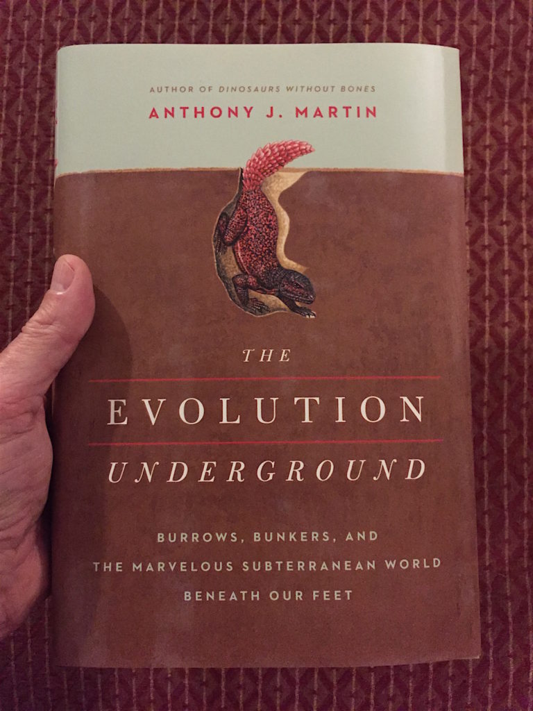
It’s here! After about two years from start to end, The Evolution Underground is out of its literary bunker and into your hands. (Photo by Anthony Martin.)

Is a book about burrows and burrowing animals too far beneath you to read? Well, as the immortal Kenny Loggins might say: Do what you like, and do it naturally.

The Evolution Underground is my seventh book and the second written overtly for a popular-science audience, following Dinosaurs Without Bones: Revealing Dinosaur Lives through Their Trace Fossils (2014, also by Pegasus Books). Dinosaurs Without Bones was a successful debut for me as a popular writer, with not-bad sales and mostly positive reviews (such as this, this, and this). That book was also my first attempt to make the word “ichnology” (the study of traces) more mainstream, and by using those always-charismatic dinosaurs as a hook. It worked, and I now think the percentage of people confusing ichnology with ichthyology has gone down ever so slightly since that book came out.

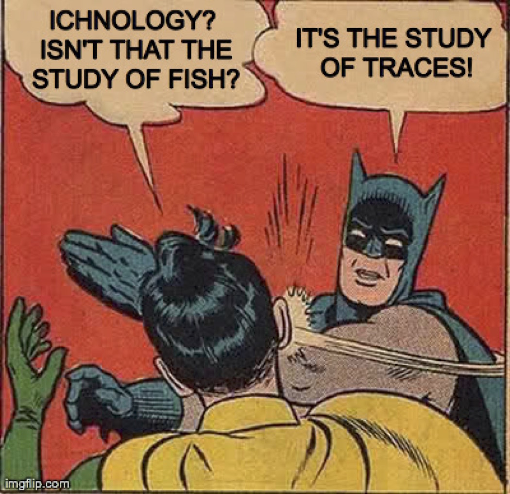
It’s ichnology, not ichthyology. Make sure you get it right, because you do not want to be slapped by Batman.

For fans of Dinosaurs Without Bones, I’m happy to report my new book – which is officially published today, February 7, 2017 – includes dinosaurs and it’s about ichnology. But it also includes plenty of paleontology, geology, ecology, and good, old-fashioned natural history throughout. Moreover, this book gave me a chance to introduce readers to a panoply of animals representing the past 550 million years of earth history, while also exploring the big idea that burrowing impacted the evolution of many animals and their ecosystems.

What’s it like to be a gopher tortoise? Kind of like being a subterranean landlord, considering that you might be sharing your burrow with 300-400 other species of animals.(Photograph by Anthony Martin, taken on St. Catherines Island, Georgia.)

Along those lines, main themes of the book are expressed in subtitles I considered for it: How Burrows Changed the World and Better Surviving through Burrows. For the former, the mere collective action of burrowing animals – from the deep seafloor to mountaintops – is an essential part of how most ecosystems function. For the latter, burrows were all-natural bunkers enabling animals to escape the worst the Earth (or solar system) could throw at them and allowing their evolution to continue underground. Want to survive a mass extinction? Start digging.

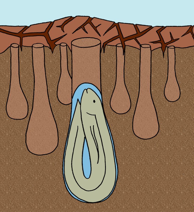
Lungfishes since the Devonian Period (more than 350 million years ago) have burrowed to avoid droughts, and their lineage has survived four mass extinctions. Coincidence? Probably not. (Original illustration by Anthony Martin, in The Evolution Underground (2017).)

Must you buy this book, or at least persuade your local public library to get it? Well, yes, if you insist. Still, just in case you first need to know a bit more about the burrowing animals and geologic times represented in between its front and back covers, here’s a chapter list with brief descriptions of their contents. Thanks in advance, and I hope you and other readers enjoy reading it.

The Evolution Underground: Chapter Titles and Synopses

Chapter 1: The Wondrous World of Burrows – Did you know that alligators make burrows? They do indeed, and they’re awesome burrows. Learn how these body-armored saurians straight out of central casting from the Mesozoic Era provide superb living examples of how many animals use (or used) burrows to survive and thrive, thus symbolizing many of the main themes of the book.

Chapter 2: Beyond “Cavemen”: A Brief History of Humans Underground – Since the time of living in caves, humans have gone beneath the Earth’s surface during times of environmental or societal stress, and we still do. In this chapter, travel to Turkey, China, Russia, Australia, Canada, and the far-off exotic land of Pennsylvania (home of weather-predicting groundhogs) to marvel at how humans, time and time again, have looked below when seeking safety.

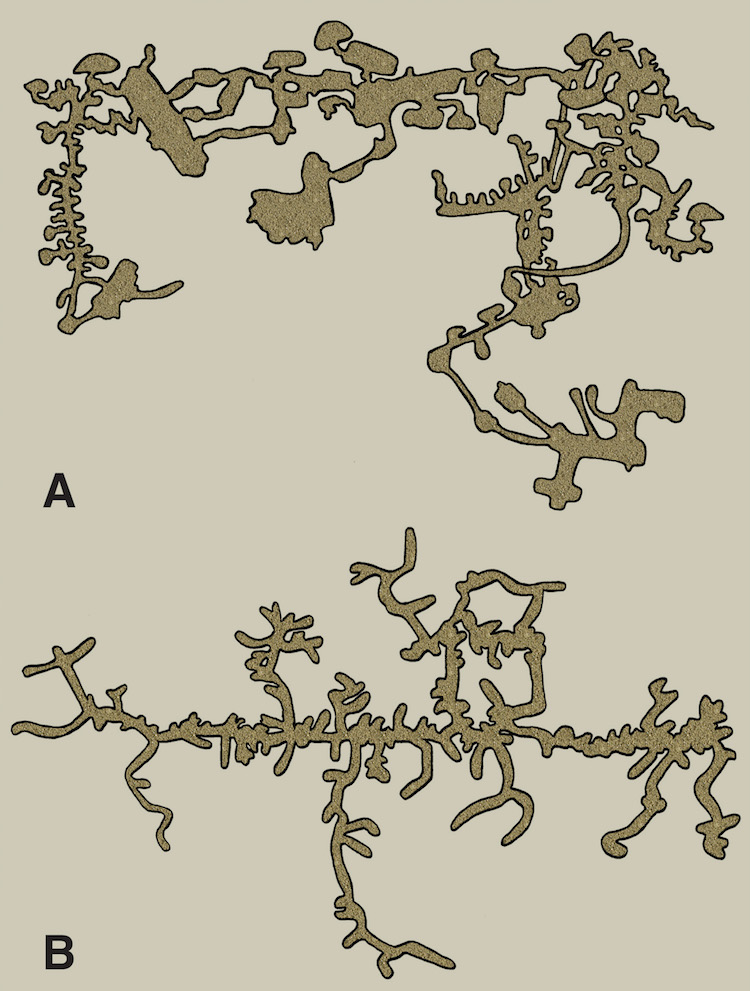
One of these is a map of a naked mole rat burrow system, and the other is of an underground city made by humans in central Turkey. Which is which? That might be one of many questions answered by reading my new book. (Original illustration by Anthony Martin, in The Evolution Underground.)

Chapter 3: Kaleidoscopes of Dug-Out Diversity – Gopher tortoises of the southeastern U.S. dig burrows that are both deep and meaningful, as these burrows host underground menageries of many other species, boosting the biodiversity of their ecosystems. How did tortoises and other turtles evolve and survive mass extinctions of the past? If you answered “burrowing,” you’re catching on to what this book is about.

Chapter 4: Hadean Dinosaurs and Birds Underfoot – Although burrowing dinosaurs of the Mesozoic past were apparently rare, a few of their living descendants (birds) evolved to put their nests not in trees, but underground. In this chapter, penguins, puffins, shearwaters, owls, kiwis, bee-eaters, and other birds raising underground families are lauded for their digging family values.

Chapter 5: Bomb Shelters of the Phanerozoic – This chapter opens with a piece of fiction about a Lystrosaurus (or two) embarking on a post-apocalyptic journey. This allegory conveys how burrowing helped their kind and a few other animals to survive the worst mass extinction in the history of life at the end of the Permian Period (about 250 million years ago). This chapter also summarizes other mass extinctions and how burrowing provided an advantage for making it through the worst ecological crises of the geologic past.

Chapter 6: Terraforming a Planet, One Hole at a Time – When did animals move from the sea to freshwater and then onto land? Burrowing may have helped animals to make transitions from such environmental extremes, which ultimately resulted in their shaping landscapes as we know them today. Featured animals in this chapter include trilobites, horseshoe crabs, lungfish, amphibians (frogs, toads, salamanders), lizards, and snakes.

Chapter 7: Playing Hide and Seek for Keeps – For a long time, all animal life was superficial, living either on seafloor surfaces or just underneath. Then about 550-540 million years ago, animals starting plumbing deeper. What caused this downward shift, and how did animals’ churning of oceanic sands and muds forever change the oceans, atmosphere, and the evolution of life? Also, the evolution of predators gave animals yet another reason to burrow: That is, before the predators started burrowing, too, starting an underground “arms race” that continues through today.

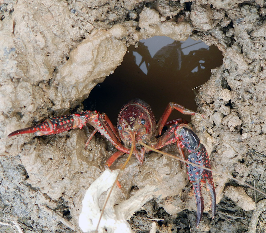
Chapter 8: Rulers of the Underworld – What animals are the real ecosystem engineers for our planet? Mostly the small and spineless ones, invertebrates. This chapter starts with those marvelous earthworms that so beguiled Charles Darwin, then pays tribute to the amazing feats of burrowing and animal architectures created by ants, crayfish, crabs, lobsters, and more.

Chapter 9: Viva La Evolución: Change Comes from Within – This chapter starts with the second fictional story in the book, following the exploits of an ecological hero – a pocket gopher – following the 1980 volcanic eruption of Mount St. Helens. The rest of the concluding chapter of The Evolution Underground looks at burrowing mammals (especially rodents), but also considers the largest burrowing animals of all time. Also, what can we as mammals learn from our fellow furry underground relatives as we head into an uncertain future posed by rapid climate change?

Appendix: Genera and Species Mentioned in The Evolution Underground – A listing of the animals name-dropped in the book, some of which may surprise you.

What are you waiting for? Leave your underground hidey-hole and get my book! P.S. Thanks for reading it. (Photograph by Anthony Martin, taken in Decatur, Georgia.)


Teaching about Traces as Evidence

With the start of a new academic year, many university professors might be deliberating on what they’ll be teaching, and many students similarly (and hopefully) might be wondering what they will be taught. For me this academic year, my plan is not to put so much emphasis on the “what,” but more on the “how,” and put it in the form of a basic question: How could I be wrong?

In my experience, this is a question we professors and other educators we often ask, regardless of whether we are in the natural sciences, social sciences, humanities, or some blend of those educational realms. Now, this is not to say that we should continuously live our lives in doubt of our hard-earned skills and knowledge, succumbing to imposter syndrome. So what I will suggest is that we use it in our teaching, leading by example for our students. For instance, when my students see me question an initial interpretation of mine, correct that wrong interpretation, and show delight when this happens, then they will feel more comfortable asking themselves the same question, too.

So how do I apply this method to my research disciplines of paleontology and ichnology? If I am observing a natural phenomenon in the field, museum, or other settings, and I find myself jumping to a conclusion too rapidly, I take a moment to pause, back up, and try to disprove that hasty conclusion. Sometimes it turns out that, yes indeed, I was an idiot. But if this debunking process fails to find anything terribly wrong with my original explanation, or I modify it accordingly in the face of newly acquired evidence, then I’ll think this: So far, so good.

Eight-Legged-Otter-TracksWhoa, check out the tracks made by this eight-legged river otter! This eight-legged otter must have been the result of some freak mutation, or genetic engineering, or joined twin otters, or a robot spider with otter feet…What? Was it something I said? (Scale in centimeters; Photo by Anthony Martin.)

Moreover, because so much of paleontology and ichnology involves interpreting the products of non-witnessed lives, behaviors, and environments, such as bones, shells, leaves, tracks, and burrows, careful documentation of this evidence is key for making reasonable interpretations. Because we can’t prove ourselves wrong by watching a video of whatever happened in the pre-human past, we also have to ensure that the evidence can be shared and evaluated by other paleontologists and ichnologists.

In the following video, I explain these two basic scientific principles – how could I be wrong, and so far, so good – by using a few examples from a forested area next to the Emory University campus in Atlanta, Georgia. This is the place where I often teach first-year (freshman) students in a small-class seminar how to track the animals on and around our campus. Because most of these animals are nocturnal, most remain “invisible” to the students’ during their four years on campus. So my students really do learn how to use trace evidence to make reasonable hypotheses about animal presence and behaviors, and by the end of the semester, they get pretty good at it.

This sort of educational fruition is what made for the most fun part about doing this video, which was having a former student of mine who took the class four years ago play the role of my willing and eager “student.” In this, we demonstrated how the two basic principles – how could I be wrong, and so far, so good – are applied when in the field. It actually wasn’t much of a stretch for my former student, as Dorothy (Dottie) Stearns (Emory College ’16) was one of my best students in the class when she took it, and she really enjoys getting outside and tracking, so her enthusiasm is genuine.

The video is part of a series that Emory is producing on the theme of Evidence at Emory, with professors from a wide variety of disciplines explaining how they incorporate evidence-based reasoning in their courses. First-year students at Emory are the specific target of the videos so they are exposed to different disciplines and how scholars evaluate evidence in those disciplines. But there’s also hope that students will retain these discernment skills in life after college. Nonetheless, I think anyone who likes observing and thinking about what they observed can benefit from watching them. I could be wrong on that, but if not, I’m fine with that, too: for now.

Eight-Legged-Otter-TracksWait a minute, you’re saying these tracks could have been made by two otters, with one following closely behind the other? Huh, hadn’t thought of that. But that doesn’t mean eight-legged otters aren’t out there somewhere. Or freak mutated otters. Or genetically engineered otters. Or a robot spider with otter feet. What? Was it something I said?

Acknowledgements: Thanks to the Quality Enchancement Plan of Emory University for encouraging me to more overtly incorporate evidence as a main theme in my class, to Dottie Stearns for being such an awesome student/actor, and to the Center for Digital Scholarship, also of Emory University, for their fine work on the video production.

Looking for Traces in an Ordovician Sea

It might seem a bit strange to consider traveling back 450 million years as a “homecoming.” But geologists time travel often enough to qualify as Time Lord apprentices, regardless of whether we are traveling by phone booth, car, or on foot. What creates this situation is how geologists may experience much of their training, teaching, or research interests in rocks of a certain age, gaining a certain comfort level when dealing with the earth of that time.

Cincinnatian-Outcrop-2“Hey everyone, let’s go to the Ordovician!” “Sounds good to me. Road trip!” You can do this when you live in a place with abundant, fantastically preserved, and freely available fossils. Which incidentally describes the area around Cincinnati, Ohio. (Photo by Anthony Martin.)

For me, my most recent homecoming was to the Ordovician Period, a geologic time span of about 488-444 million years ago. As a geologic period, its life and marine environments are represented quite well by the world-class fossil-bearing limestones and shales in and around the area of Cincinnati, Ohio. This is where I gained my formative training as a paleontologist, as I studied Ordovician rocks and fossils in the area while working on an M.S. degree in geology at Miami University in the mid-1980s. (Incidentally, Miami was a university before Florida was a state, and the rocks around it are much older than any in Florida, too. As a matter of pride, then, I like to inform people that I went to the “real” Miami.)

So last month I was lucky enough to participate in two field trips and a paleontology mini-conference in the region of Cincinnati, Ohio, which felt very much like a homecoming. The field trips and conference were co-sponsored by: the myFOSSIL Project, an NSF-funded initiative working to unite avocational (“amateur”) fossil collectors with professional paleontologists while enhancing STEM (Science Technology Engineering and Math) through the science of paleontology; The Dry Dredgers, a fossil-collecting club founded in 1942 (!) in Cincinnati, and consisting of some of the most knowledgeable and enthusiastic collectors I’ve met anywhere; the Cincinnati Museum Center, which hosted the conference and keynote talk (more on that soon); and the Paleontological Society, which was ably represented at the mini-conference by their current president, past president, and other officers and members.

Cincinnati-Musum-CenterExterior of the Cincinnati Museum Center, which helped to host the Paleontology Mini-Conference, houses a fantastic collection of Ordovician-age fossils, and served as the venue for a keynote talk given by Yours Truly. The museum building originated as the Cincinnati Union Terminal in 1933 and was later converted into the museum in 1990. It’s a very neat place for both its art-deco architecture and its displays, and every visit to the Cincinnati area should include it. Right after having some Skyline Chili and Graeters Ice Cream, that is. (Photo by Anthony Martin.)

Already I’ve listed many reasons for being there, but the main incentive was as the keynote speaker for the mini-conference, an invitation I received and gratefully accepted late last year. For that, I gave a public lecture at the Cincinnati Museum Center on a Friday night, and on the topic of my most recent book, Dinosaurs Without Bones (2014). I had my usual fun time with the lecture, the audience had a variety of thoughtful questions for me to answer and otherwise discuss, and I happily did a book signing afterwards. We were then given a tour of the museum, which has world-class Ordovician fossils in it and much more.

Sound great? It was. But the real highlight of my journey was seeing the Ordovician rocks and fossils in the area. Hence I had to participate in the pre-meeting and post-meeting field trips to various roadcuts in Kentucky, Indiana, and Ohio while there. As an ichnologist, I was was also keenly interested in revisiting the trace fossils in these rocks, which I had not seen in a long time (by human standards). Accordingly then, the following photos show some of the people and outcrops we visited, but really focus on the coolest trace fossils I saw, accompanied by my attempts to explain each.

Many thanks to everyone who made the 2016 Cincinnati Paleontology Mini-Conference happen, and much appreciation for taking me back “home” to the Ordovician.

Dry-Dredgers-Carl-BrettThe pre-meeting field trip and part of the post-meeting trip benefited from the presence of the indefatigable Dr. Carl Brett from the University of Cincinnati. I am continually awed by both his knowledge of the Ordovician rocks and fossils and his unrestrained enthusiasm for sharing this knowledge. Even better, he loves trace fossils, which officially makes him my new best friend. (Photo by Anthony Martin.)

Cincinnatian-Outcrop-1Roadcuts like these, all chock full of Ordovician body fossils and trace fossils, make me and other paleontological connoisseurs very happy. (Photo by Anthony Martin.)

Rusophycus-CincinnatianCarl Brett found these gorgeous trilobite resting traces at the very first outcrop, which at first made me a little jealous, but I got over it quickly enough after staring at these beauties for a few minutes. These were probably made by a species of Flexicalymene, which burrowed down into a firm mud below, possibly to hide from predators but also as shelter from other problems above. Later, silt and fine sand filled in the depressions, making these natural casts. Be sure to look for the little trilobite tracks, too.

Small-Cruziana-CincinnatianHow about the cutest trace fossil I saw? Here’s a tiny trilobite burrow I found on the bottom of a siltstone bed (my thumb is pointing to it). The dual pathways mark where its little legs pushed down and into the sediment below it; it have been made by a juvenile or full-sized adult that just happened to be really small. It is again preserved as a natural cast, so you’re looking at the bottom of the bed. (Photo by Anthony Martin.)

Palaeophycus-Cincinnatian
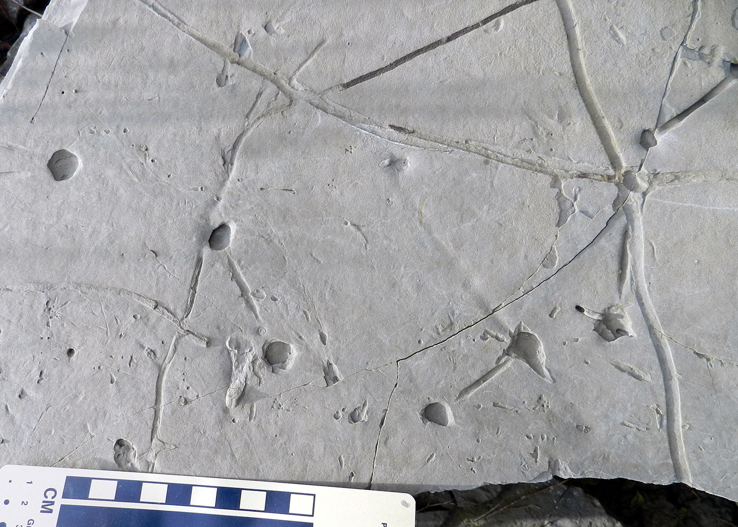
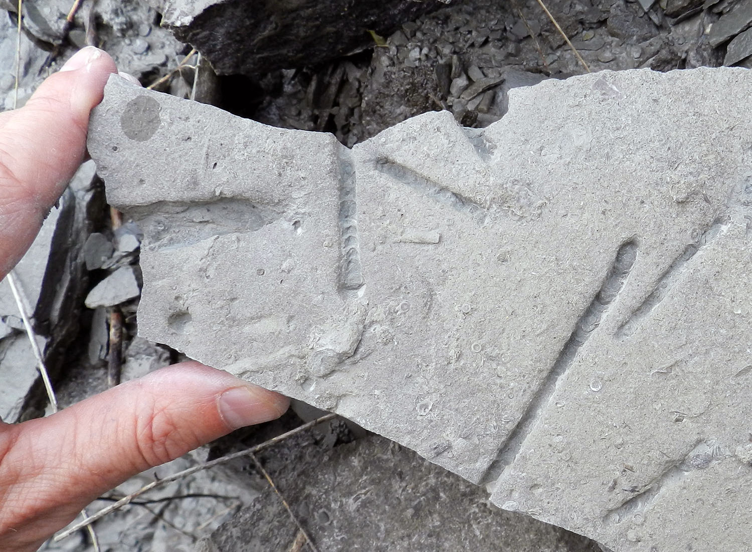
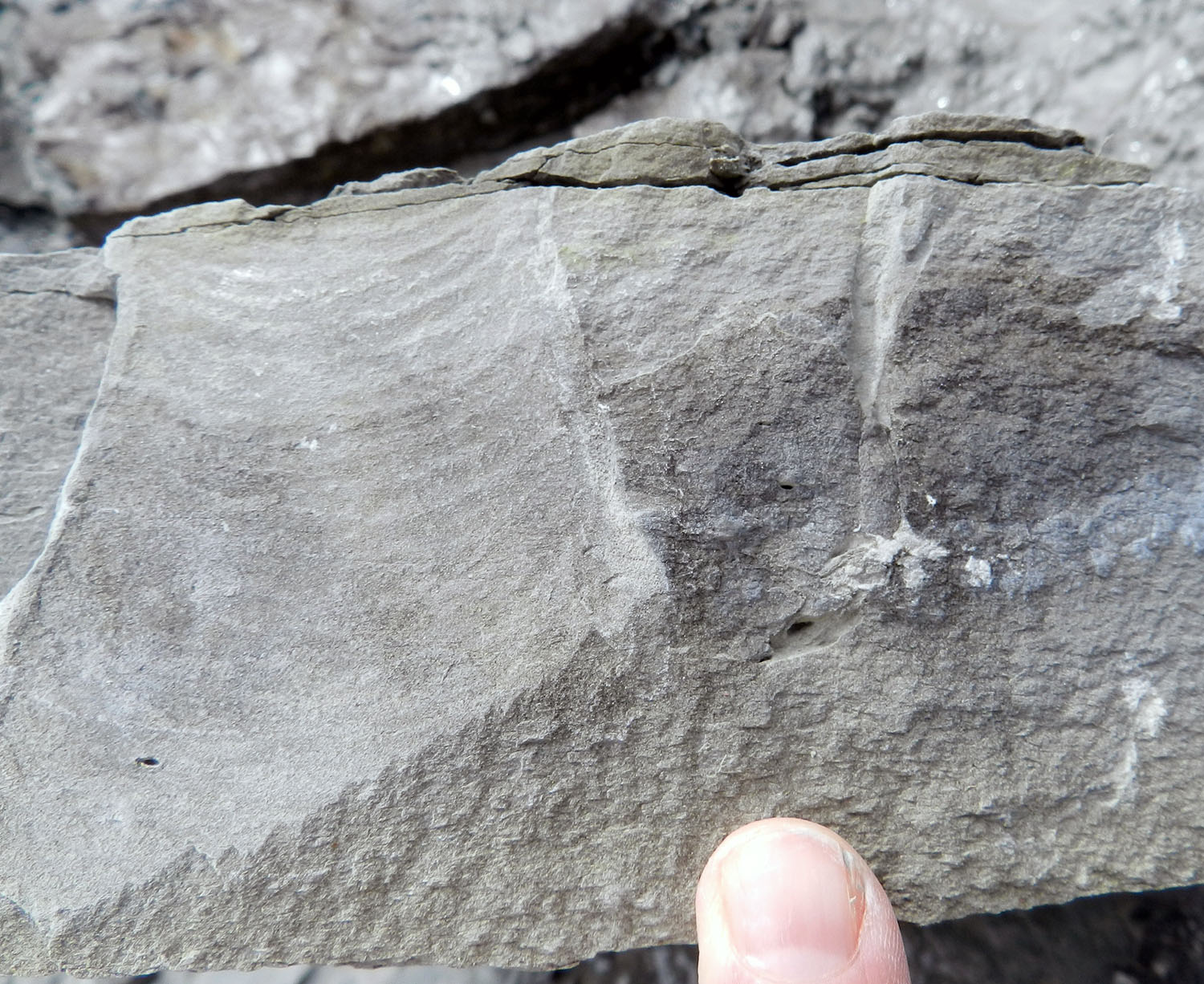
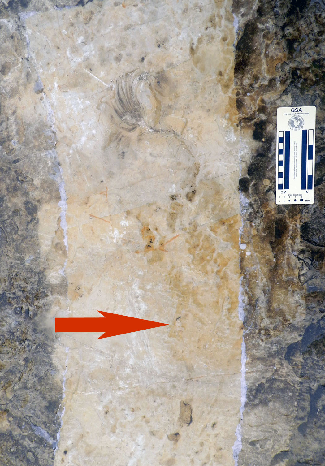
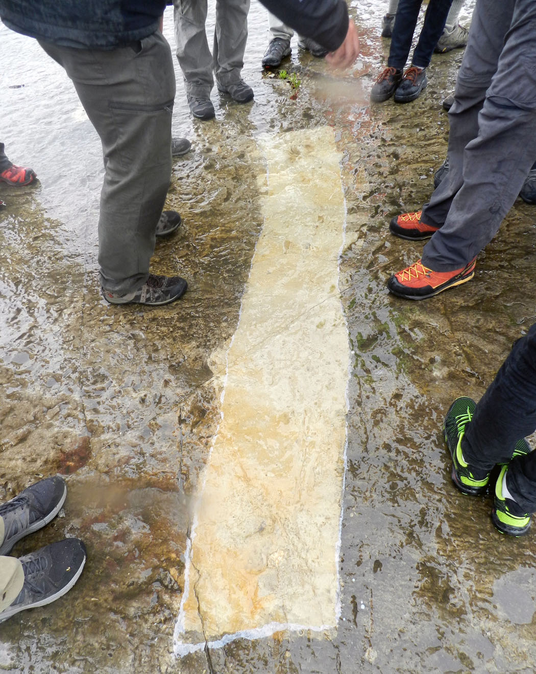
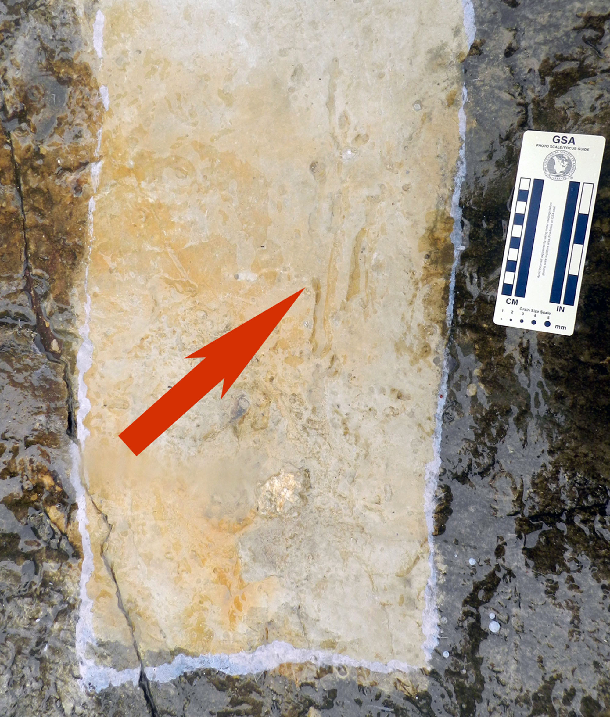
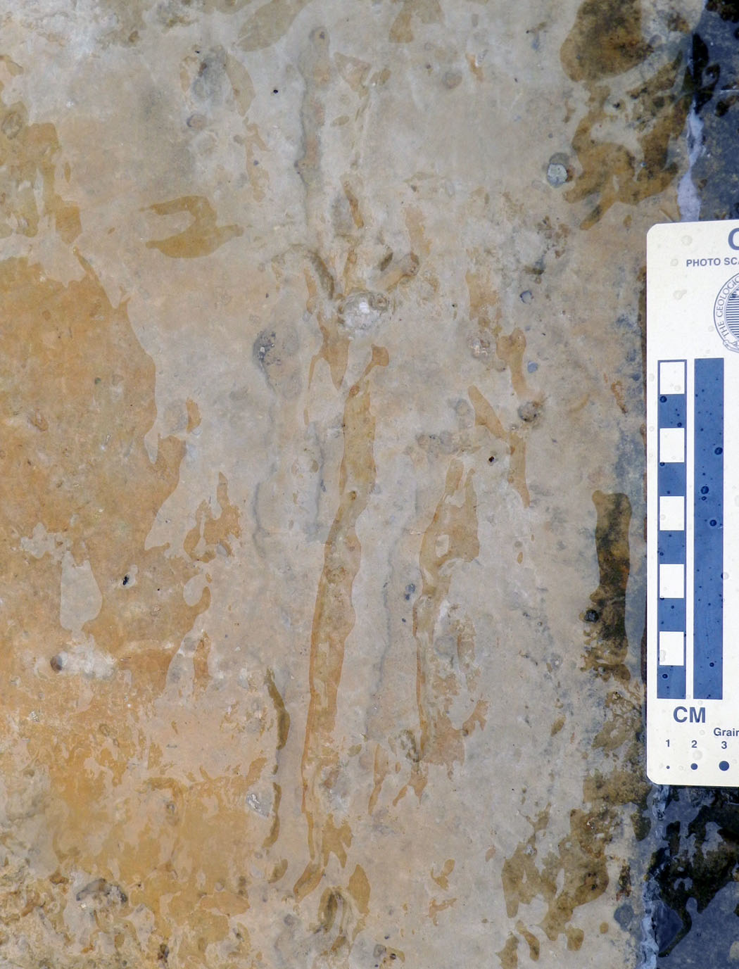
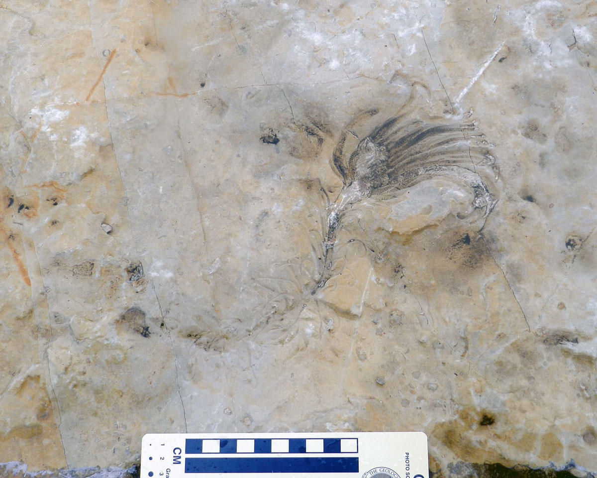
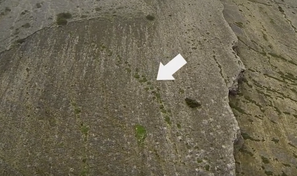
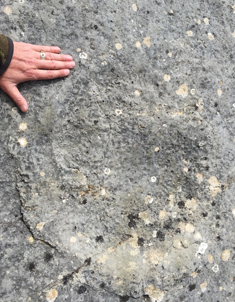
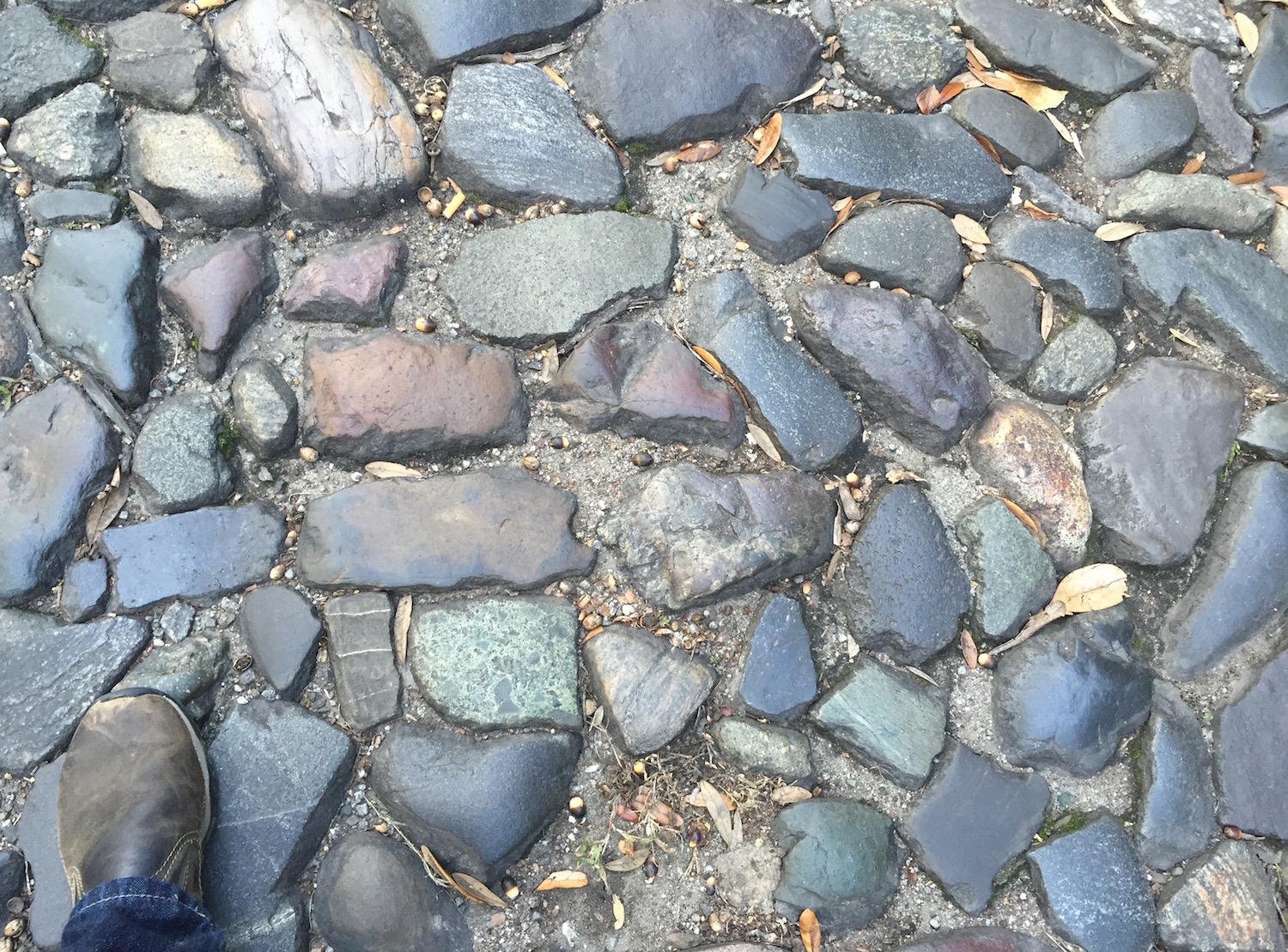
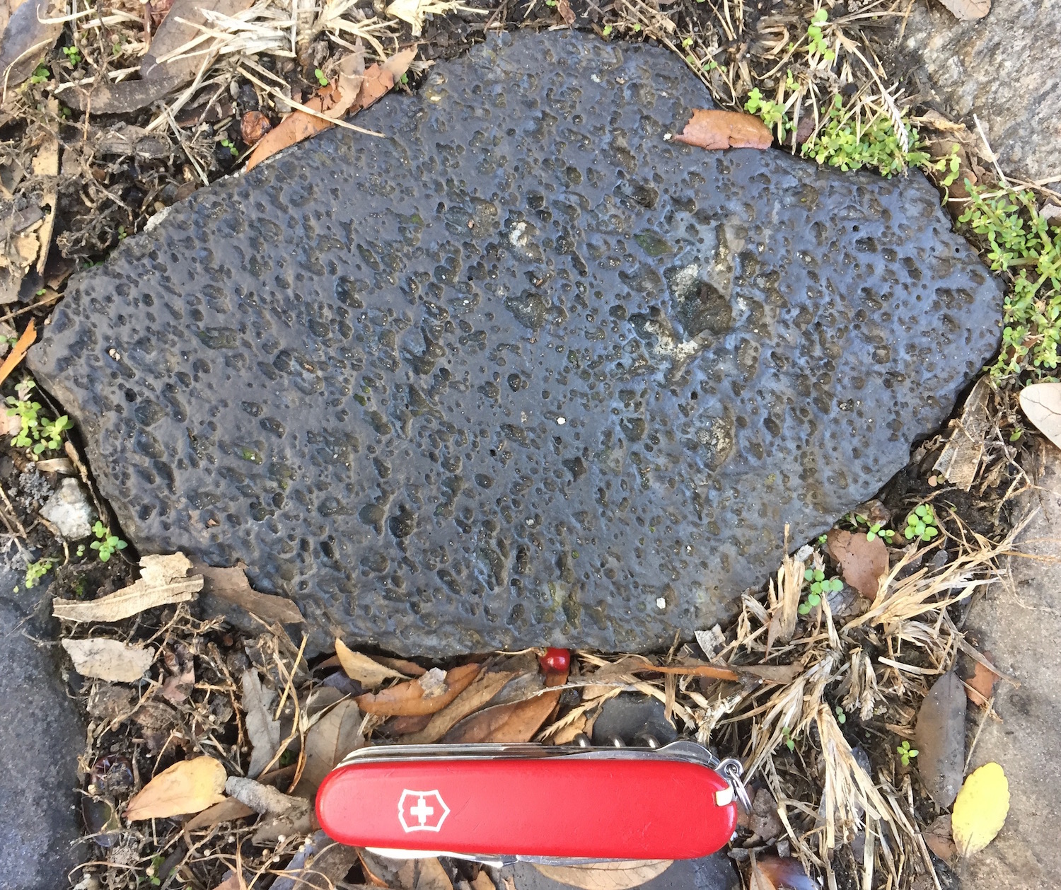
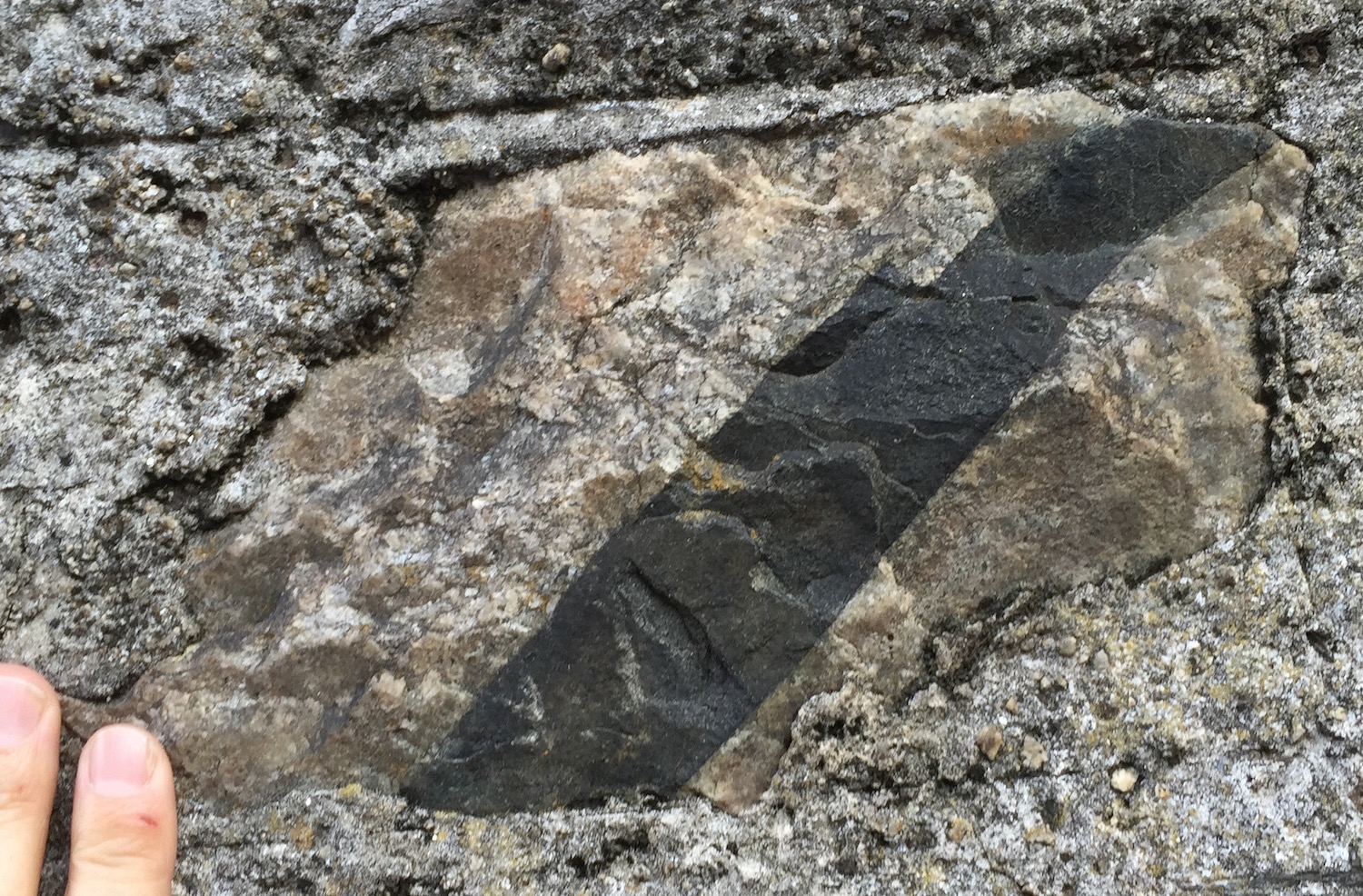
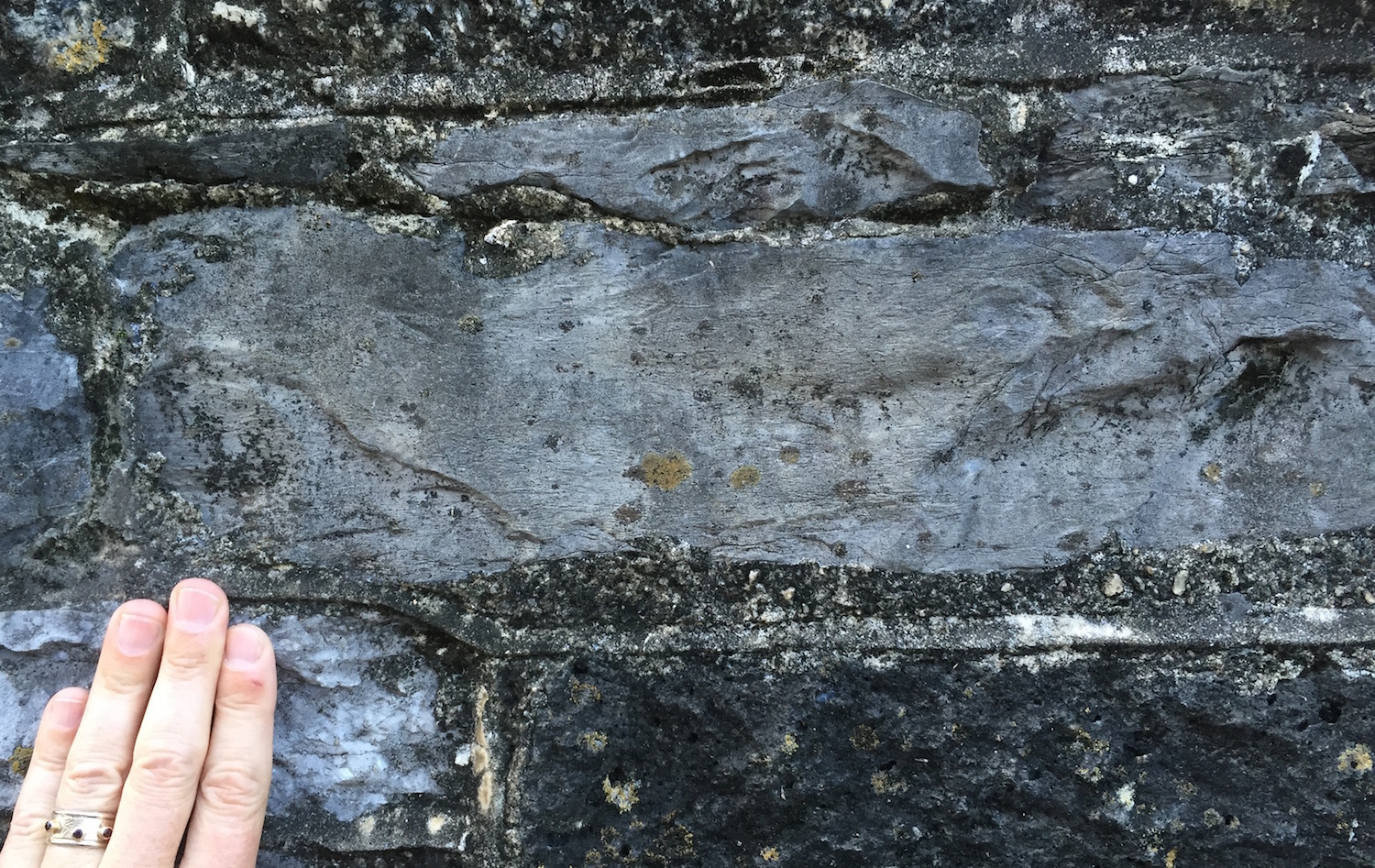
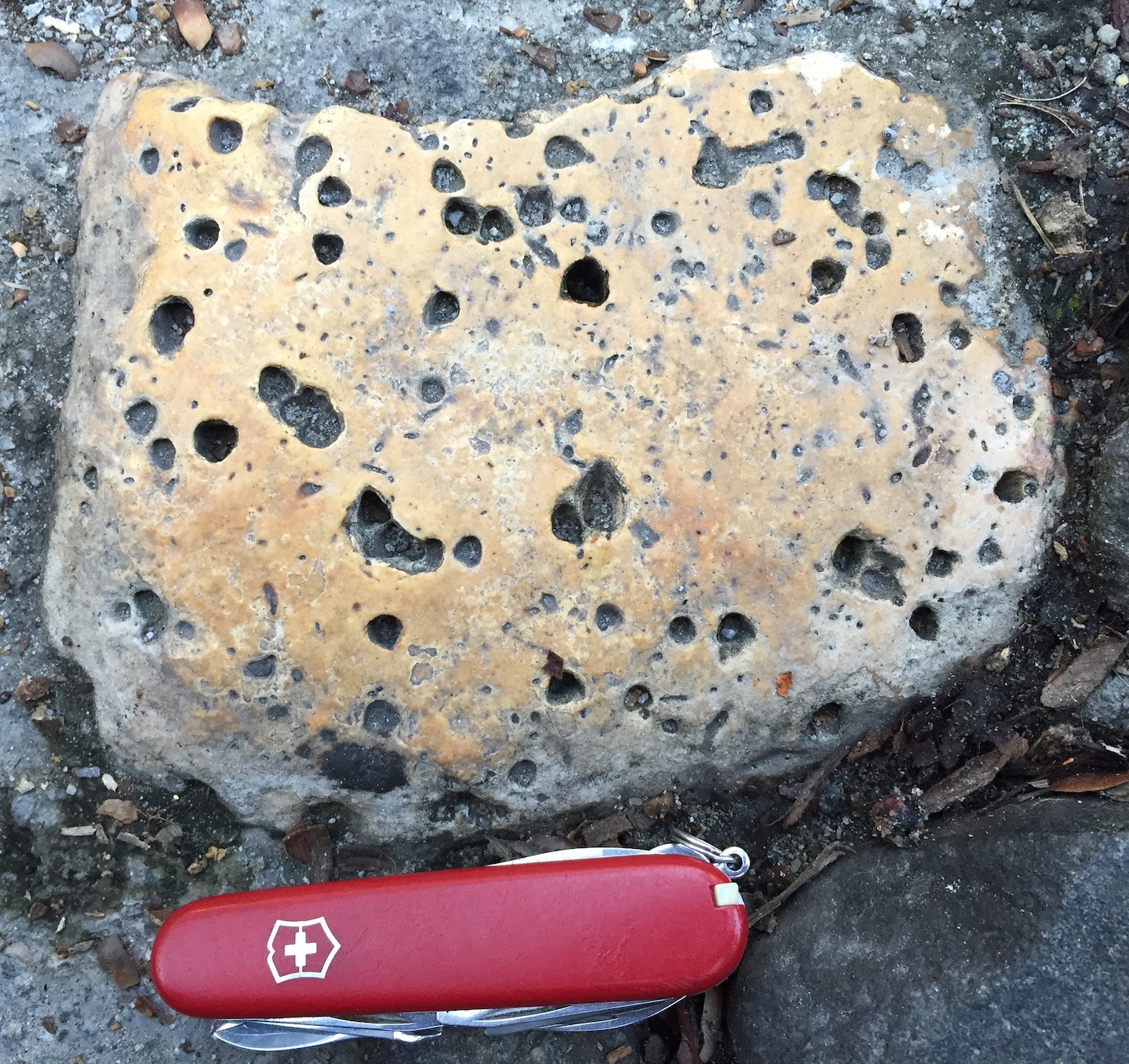
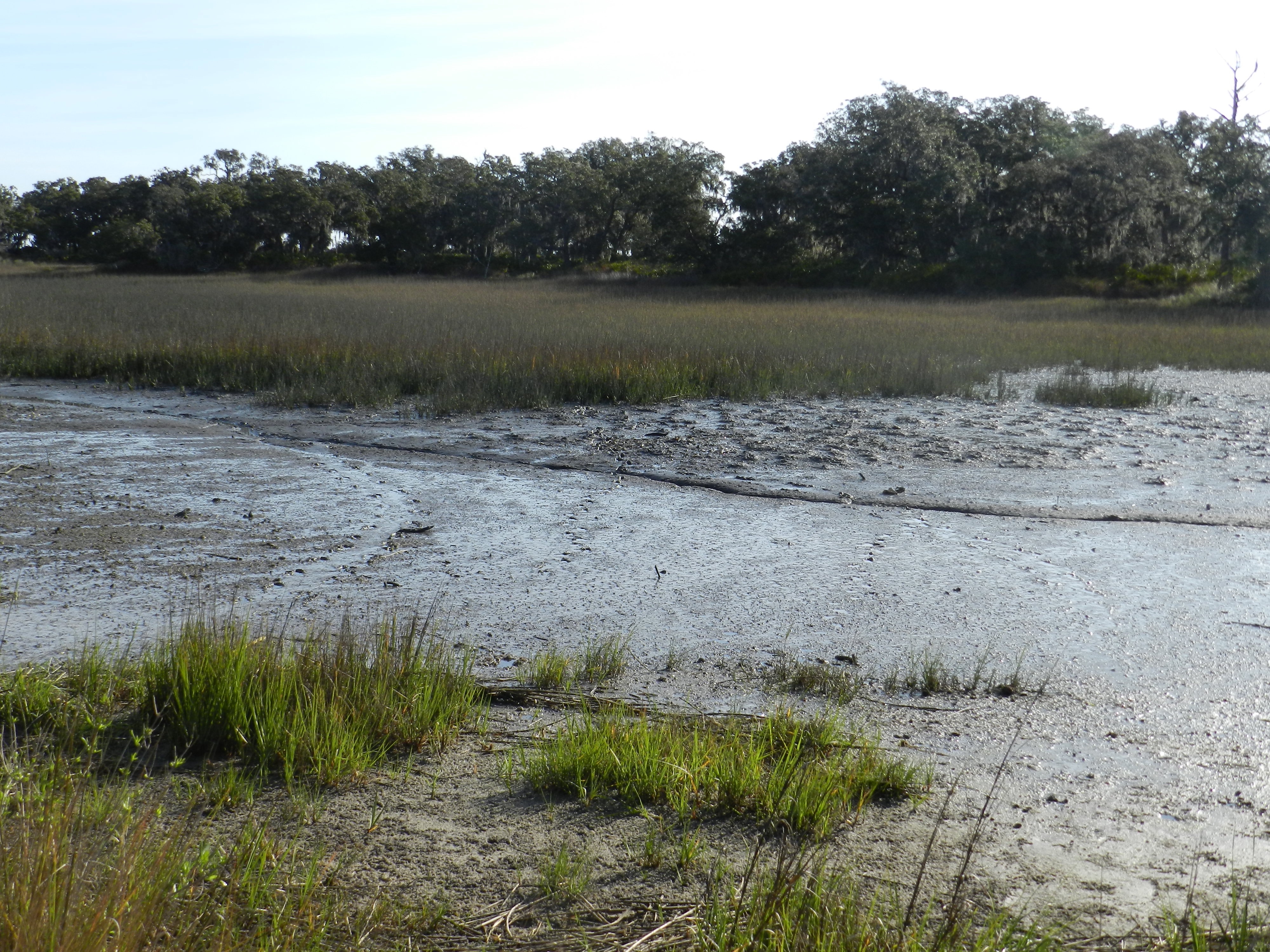
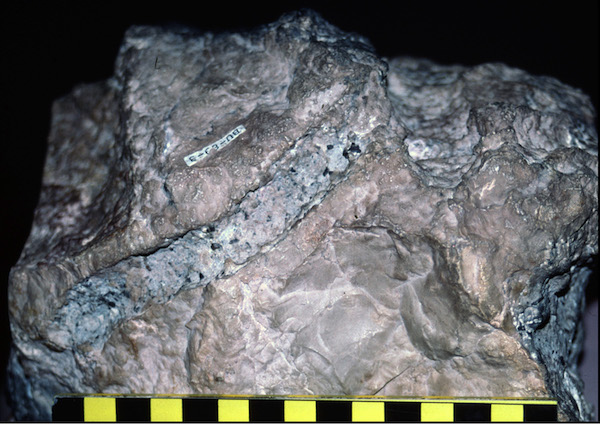
Most of these trace fossils are compressed and intersecting horizontal burrows, which are  visible because they are filled with a different sediment than the surrounding rock. Notice smaller-diameter and more complicated burrow system to the right, which apparently was made first, as the other burrows cut across it. Both were likely feeding burrows made by worm-like animals. (Photo by Anthony Martin.)
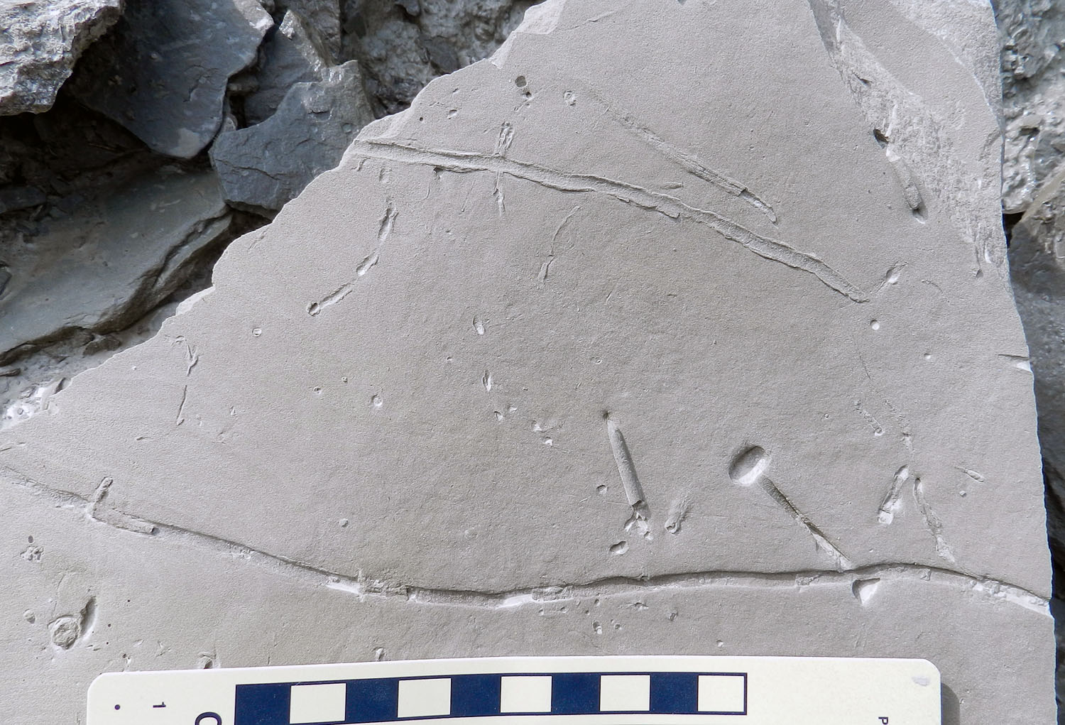
Diplocraterion-Palaeophycus-CincinnatianAt least four different types of trace fossils are on this slab: the little “pockmarks” that also show some branching; the lined burrow toward the top of the slab (eroded so that it looks like a snail trail); the long, discrete burrow just above the scale, and the “dumbell” one on the lower right. Applying the principle of cross-cutting relations, can you work out the sequence of which burrow came first, second, third, and last? All were likely made by wormy critters and are feeding burrows, although the “dumbell” burrow also served as a home, as we’re looking at the top of a U-shaped burrow. More on that with the next photo… (Photo by Anthony Martin.)

Diplocraterion-CincinnatianThe trace fossils on this surface are similar to that of the previous one, but has a lot more “dumbells,” which represent U-shaped burrows that were originally tubular, with the critter – maybe a worm, maybe a crustacean – having its head close to one opening and its rear end close to the other. To visualize these burrows in three dimensions, make a “U” with your thumb and forefinger, turn it so you are looking at the tips of your fingers, and imagined a line of collapsed sediment between the two limbs of the “U.” (Photo by Anthony Martin.)

Diplocraterion-Spreite-CincinnatianThese are bottom expressions of the U-shaped burrows, but omitting the tubes. The curved lines inside the linear parts show where the maker of the U-shaped burrow moved its burrow up or down in response to what was happening on the surface. A little confused by that? You’re not alone, and welcome to my world. (Photo by Anthony Martin.)

Diplocraterion-Cross-Section-CincinnatianHere are partial vertical sections of two U-shaped burrows, with the one on the left also displaying the internal structure made by animal as it moved its burrow up or down, depending on whether it had sediment dumped on top of its burrow (move up!) or the top was eroded (move down!). I think this one went down, but can’t say for sure without seeing the burrow bottom, which is not preserved here. (Photo by Anthony Martin.)

Chondrities-CincinnatianThis branching burrow, which if reconstructed in three dimensions would look like an upside-down bush, was made by an animal (or several with their burrows overlapping) feeding on the sediment. The branches are from repeated probing into the surrounding sediment, then withdrawing, then probing again. (Photo by Anthony Martin.)

Dry-Dredgers-1What other trace fossils are in these outcrops of Ordovician limestones and shales? Too many for these people to see them all and study, but clearly they don’t care. And that’s a good thing. (Photo by Anthony Martin.)

The Death Crawl of a Jurassic Crinoid

Think of a crinoid, and you will likely visualize one of these gorgeous echinoderms looking like a colorful, delicate flower on a brightly lit seafloor, aptly justifying its nickname as a “sea lily.” Take your crinoidal fantasy just a bit further, and imagine its fine, feathery arms gently waving in harmony with ocean currents passing through them, its stalk bending with each current, but otherwise staying firmly attached to a sea bottom. If you know a little more about crinoids, though, you might also think of one without a stalk – a “feather star” – swimming above the ocean floor, performing an aquatic dance reminiscent of the Hindu Mother Goddess Durga.

A swimming stalkless crinoid (“feather star”) at the Tanjung Papaya dive site, Mandado Bay, Indonesia, recorded by Pim Van Schendel in October 2015. Notice how its barely touches the sandy bottom, leaving few clues of its behavior in the sediments below.

You might also let your dreams go back to the ancient past, when crinoid “meadows” blanketed shallow-marine environments throughout the world, starting about 450 million years ago in the Ordovician Period and continuing through the Paleozoic Era. By the Carboniferous Period, crinoids were so abundant that their body parts contributed to limestones we now use for buildings. Following the mass extinction at the end of the Paleozoic, crinoids became more rare, but several lineages persisted through a few more mass extinctions, including the living ones that delight us today.

Ordovician-Crinoid-Slab-Cincinnati-MuseumAn Ordovician crinoid “meadow,” buried by a tropical storm about 440 million years ago. Slab is about 2 m (6.6 ft) wide, and more than a hundred exquisitely preserved  are preserved on it. Specimen is at the Cincinnati Museum Center (Cincinnati, Ohio), and was discovered, recovered, and donated by Dan Cooper of The Dry Dredgers fossil club to the museum. (Photograph by Anthony Martin.)

Now, instead of such idyllic reveries, think of a crinoid experiencing a slow, agonizing death. Imagine it imitating the clichéd image of a man crawling through a desert and croaking the word “water” as it pulls itself along a barren and air-filled landscape, searching for a comforting sea. If this is not a jarring enough of a picture for you, don’t worry, it gets worse. The crinoid doesn’t quite make it to the sea, and when it can’t move any further, it tries in vain to attach itself to the land beneath it. Minutes later, it dies. A few hours pass before it is finally submerged (too late) by the next high tide, its body put to rest under a blanket of sediments.

The real twist to this story, though, is how 170 million years later, some upright bipedal primates – at least a few of whom were quite fond of crinoids – spotted this one on a ground surface in the middle of present-day Portugal, still connected to its last trail of life.

Jurassic-Crinoid-Trail-Portugal-4

The only known trace fossil of a crawling crinoid in the geologic record in a limestone bed of the Chãi des Pias Formation (Middle Jurassic, about 170 mya) near São Bento, Portugal. The red arrow points to the trail, evident here as a shallow, meandering, and slightly darker groove. How do we know a crinoid made it? Because it ends with a crinoid. Its last three decisions were to move to the right, then to the left, and stop forever. (Photograph by Anthony Martin.)

I was lucky enough to see the only known trace fossil of a crawling crinoid and the crinoid that made it during a paleontological field trip last month in Portugal. The trip was connected to the International Ichnological Congress, a once-every-four-year meeting simply known as Ichnia. The field-trip stop with the crinoid and its trail was at a relatively modest outcrop of Middle Jurassic limestone near the Portuguese parish of São Bento (Porto de Mós municipality).

Despite constant rain that day and the small area exposed at the field site, its trace and body fossils grabbed our attention, then held us as willing captives for more than an hour. Among the ichnological treats offered by this Jurassic tidal-flat deposit were crab trackways – including what might be the longest invertebrate trackway in the geologic record – long snail trails, crustacean burrows, fish trails, and much more. For those people who love body fossils, and especially of echinoderms, the rock also held beautifully preserved sea stars and spiny sea urchins. It was marvelous, and for days afterwards, all of the trip participants talked about this place and its bounty.

Given such fossil riches, it is tempting for me to share them all with you here. Nonetheless, I will instead focus on the star: not a sea star, but a relative. Despite the rain, its trail was easy to spot, as it was located inside of a white-yellow strip on the surface of an otherwise dull-gray limestone. The area surrounding the trace fossil had been inadvertently brightened by the researchers studying it. When they made a latex mold of the trace fossil, the latex took some of the weathered surface with it. From my perspective, it looked like a landing strip. Which, in a sense, it was.

Jurassic-Crinoid-Trail-Portugal-1Crinoid coming in for a landing, the hard way. The bright area marks where paleontologists made a latex mold of the crinoid trail, but also. shows how it crawled for more than 2 m (6.6 ft) along the tidal-flat surface. The crinoid is at the far end of the strip. Based on all of the paired shoes with people wearing, one might conclude that the rain was doing a poor job of dampening our enthusiasm. (Photograph by Anthony Martin.)

Jurassic-Crinoid-Trail-Portugal-2A close-up of the first part of the crinoid trail. Once stranded on the tidal flat, it began dragging itself across the originally soft sediments, leaving a groove from its stalk and impressions from its arms (arrow). Scale has centimeters on the left and inches on the right. (Photograph by Anthony Martin.)

Jurassic-Crinoid-Trail-Portugal-3Although this fossilized crinoid trail is underwater here, it wasn’t when the crinoid made it. Exposed on the tidal flat, it tried to get back to the sea by pulling itself forward with its arms, its stalk dragging behind it. Its arms left a wake of disturbance on either side of a thinner central groove from its stalk. (Photograph by Anthony Martin.)

Jurassic-Crinoid-End-of-Trail-PortugalThe end of the trail, which was not a happy one for the crinoid, but ultimately a fulfilling one for paleontologists and ichnologists. (Photograph by Anthony Martin.)

Trace fossils that represent the last moments of an animal’s life – corroborated by a direct association of the animal with its trace – are rare, but known. Such traces, whether modern or fossil, are called mortichnia (mort = “death” and ichnia = “traces”), and this trail with its crinoid maker definitely qualifies as one. Based on this trace fossil and many other geological clues at the outcrop, it was on what was originally a tidal flat, an environment well outside of a crinoid’s comfort zone. It may have been happily filter-feeding offshore, but was uprooted by waves and washed up by a high tide.

Because this is a Jurassic crinoid, you might wonder (as I did) if any modern stalked crinoids can crawl like this, using their arms to drag themselves along a sedimentary surface. The answer is yes, they can. But this is easier for a crinoid to do when underwater, where it is more buoyant. As far as I know, no one has experimented with modern stalked crinoids to see whether they can do this on land, let alone documented any of these animals getting dumped onto a tidal flat and then trying to make it back home.

Footage of a crawling stalked crinoid, albeit one underwater. This one was observed in about 400 m (1,300 ft) deep water off Little Bahama Bank, as reported by Baumiller and Messing (2007). For a detailed analysis of its movement and the traces that would result from this, read their article here.

Although the species of crinoid that made its death crawl is not yet identified, the researchers who studied it concluded it is an isocrinoid. Paleontologists who have studied stalked crinoids figured that the first ones capable of crawling may not have evolved until the Devonian Period, about 350-400 million years ago. Until then, they were sedentary. What changed, giving crinoids good reason to get up and walk away? Probably predation. Predators, which likely included fish but also other echinoderms, must have found crinoids easy and tasty targets, which would have favorably selected for more mobile forms. As Eddie Vedder might say, it’s evolution, baby.

Ordovician-Crinoids-Cincinnati-Museum-1Once Ordovician crinoids settled down, they had no place to go. (Photograph by Anthony Martin, taken at the Cincinnati Museum Center.)

I won’t go through all the details of the report on this crinoid and the other extraordinary trace and body fossils at this site in Portugal. For that, you can read the original research article by Carlos Neto de Carvalho – who was also one of the field-trip leaders – and his colleagues, published earlier this year. All of them deserve to be famous for this extraordinary discovery, and I and my colleagues who were there all felt privileged to have seen it for ourselves, 170 million years after a crinoid went on its final journey.

Many thanks (muito obrigado) to Carlos Neto de Carvalho and Joana Rodrigues for organizing and leading such memorable field trips before and after Ichnia 2016, giving us all an appreciation for the wonderful paleontology and culture of Portugal. For more information, photos, and videos about stalked crinoids, check out Christopher Mah’s excellent post Stalked Crinoid Roundup! and other crinoid-related posts at his appropriately named blog, Echinoblog.)

References

Baumiller, T.K., and Messing, C. 2007. Stalked crinoid locomotion, and its ecological and evolutionary implications. Palaeontologia Electronica, 10, 2A. (PDF of open-access article here.)

Neto de Carvalho, C., Pereira, B., Klompmaker, A., Baucon, A., Moita, J.A., Pereira, P., Machado, S., Belo, J., Carvalho, J., and Mergulhão. 2016. Running crabs, walking crinoids, grazing gastropods” behavioral diversity and evolutionary implications of the Cabeço da Laderia Lagerstätte (Middle Jurassic, Portugal). Communicações Geológicas 103, Especial 1, 39-54. (PDF of open-acccess article here.)

Of Sacred Mules and Sauropod Tracks

Legends and storytelling are an intrinsic part of being human. Given this statement, you might then also think of myths and other stories you’ve heard throughout your life. Which were the most memorable, and why? With such remembrances, your next step may be to do something else that is very much a part of being human, which is to wonder whether that myth or story holds some lesson applicable to real life. Whether a story is an accurate account of reality is beside the point, as its imparted teachings are sometimes more important than factual accuracy.

Avelino-Sauropod-TracksModern scientists say these depressions in a tilted rock surface near Sesimbra, Portugal were made by sauropod dinosaurs in soft sediments during the Jurassic Period more than 150 million years ago. But what if you lived in this area during the 14th century? How would you explain these depressions? While you’re thinking about that, here’s another question: If I hadn’t told you these were dinosaur tracks, would you even know they were tracks? (Photograph by Anthony Martin.)

Yet, what if reality and scientific reasoning – with the latter thriving on a spirit of disproof – rudely intrudes on a good story, disrupting its original intent? In such instances, a legend previously regarded as literal truth may lose its narrative power, as we begin to doubt not just its details, but also its intent. Can anything useful be salvaged from a myth when skepticism assaults faith? Should we completely reject parables once we know foxes do not talk about grapes, sour or otherwise?

Less than two weeks ago I visited a place where the basic facts of a long-held legend had been disproved, yet a lesson from it remains. The place is Cabo Espichel, marked by a lighthouse, church, and small chapel on a plateau high above rocky cliffs along the southwest coast of Portugal. Cabo Espichel is about a 90-minute drive from the modern metropolis of Lisbon, yet it felt far more remote, and very much connected to a medieval past.

Cabo-Espichel-OutcropsA view of Lagosteiros Bay from the top of Cabo Espichel. Also check out those gorgeous outcrops of tilted Jurassic and Cretaceous rocks! Gee, I wonder what trace fossils might be in them? (Photograph by Anthony Martin.)

The legend associated with that place concerns a 14th century visitation there by someone named Mary, who is also known by many other names: Saint Mary, Mary of Nazareth, Blessed Virgin Mary, Our Lady, The Madonna, or very simply the Mother of Jesus. Given the Catholic culture that is very much still a part of the Iberian Peninsula, her purported arrival to Portugal there was (and still is) considered a blessing and a ringing endorsement of Christianity there. Accordingly, the church complex is called the Santuário de Nossa Senhora do Cabo Espichel (“Sanctuary of Our Lady of Cape Espichel”).

Cabo-Espichel-ChurchIchnologists approaching the Santuário de Nossa Senhora do Cabo Espichel, Portugal, not on the way to confess their sins (that would have taken way too long), but to see the small chapel behind it, as well as some great coastal outcrops of Mesozoic rocks. So you might say they were there for a different type of worship. (Photograph by Anthony Martin.)

How did Mary get to Portugal from the Middle East? Given the absence of airlines then, she and the Baby Jesus traveled by boat. Once the Mother and Child reached the shore of Lagosteiros Bay below Capo Espichel, a giant mule carried them up the steep rock faces of Cabo Espichel. This scene came in a vision to two men in the area, who shared the same dream of her arrival on the same night. In a splendid example of confirmation bias, their testimony was taken quite seriously by the local populace and beyond, and has endured since.

Sauropod-Tracks-Cabo-Epsichel-3Cliff face below the present-day chapel and church at Cabo Espichel, with well-exposed and tilted bedding planes of sedimentary rock. This would have been the most likely route for a mule (giant or otherwise) to have accessed the top from Lagosteiros Bay. Photo is a still taken from an online edited drone video titled “Cabo Espichel – Dinosaur Trackway Adventure.” Related to the question asked in the previous caption: Huh, I wonder what those depressions on the rock face might be, how they relate to the legend, and the title of that video?

In commemoration of this momentous event, the church and chapel – the latter called Ermida da Memória (Chapel of Memory) – were built near the precipice. Portuguese royalty hosted annual feasts there, and many pilgrims put it on their spiritual “bucket list” as a must-visit place. Today, it is still visited by devout Catholics, who may be imagining themselves walking on the same holy ground trodden by Mary and her miraculous mule.

Ermida-da-MemoriaThe Ermida do Memória seen from afar on Capo Espichel. Imagine it in the darkness of night, when suddenly a glow comes from the bay below. Inside this light, the head of a giant mule appears, and as more of its body emerges from the cliff edge, you see Mother Mary astride it carrying the Baby Jesus, accompanied by an aerial escort of angels and the most beautiful music you’re ever heard in your life. OK, Guillermo de Toro, I just wrote the scene for your next movie: the rest is up to you. (Photograph by Anthony Martin.)

So where did this legend come from: crazed fishermen who had spent one day too many at sea, villagers imbibing enthusiastically on local vinho verde, or clergymen overcome by ecclesiastic visions? No, this story actually had evidence backing it up. All one had to do is get in a boat just offshore, and you could see for yourself enormous footprints in the rocks leading from the sea to the top of the cliff at Cabo Espichel.

Sauropod-Tracks-Cabo-Espichel-1They’re a little tough to see from this far out, but the big white arrows help. The “mule tracks” are on tilted strata just above the bay, and compose diagonal-walking patterns. (Photo taken as still from video Cabo Espichel – Dinosaur Track Adventure. I would have prefaced that information with “Spoiler Alert,” but you did read the title of this post, right?)

Sauropod-Tracks-Cabo-Espichel-2A closer view of a rock surface with the diagonal-walking pattern clearly defined, accentuated by vegetation growing in the depressions. Don’t believe me that these are from the same site? Look up “Cabo Espichel, Portugal” on Google Earth™, scan the rock surfaces just north of the chapel, and see them for yourself. (Photo again is still taken from video Cabo Espichel – Dinosaur Trackway Adventure.)

These tracks, people said, marked where the weight of the mule pressed into the rocks. Even better, some of these tracks formed patterns clearly made by four-legged animals, and individual tracks were crescent-shaped, resembling the feet of mules or other horse-like animals. As a result, one name applied to this place is Pedras de Mula, which translates as “Rocks of the Mule,” although Pegadas de Mula (“Tracks of the Mule”) is also applied.

Every good story also needs images, and this one has a particularly noteworthy visual aid. The building of a chapel on the site in the 16th century contains tile artwork commemorating this divine calling; however, the tile was probably made later, in the 18th century. Although the chapel interior is closed to the public, a open slot in its door afforded a glimpse of this depiction, aided by the zoom lens on my camera. Like any good illustration, the story is neatly encapsulated in the tiles: Mother Mary and The Baby Jesus riding on a mule, with angels in tow and stunned onlookers properly prostrating.

Pedras-de-Mula-118th century tiled artwork inside the Ermida do Memória depicting the legend of Mary’s visitation of Cabo Espichel. To all artists out there (and I’m one of you), the original creator of this work is unknown, hence image credit cannot be assigned here. (Photograph by Anthony Martin.)

Centuries later, ichnology happened. Beginning in the mid-1970s, geologists and paleontologists realized that the Mesozoic rocks of Portugal, including those at and near Cabo Espichel, held dinosaur tracks. This consciousness has been affirmed many times since, with discoveries of tracks belonging to a wide variety of Jurassic and Cretaceous dinosaurs: theropods, ornithopods, stegosaurs, and sauropods among them. Portugal is now rightly renown as one of the best places in the world to see thousands of well-preserved dinosaur tracks, all within just a few hours drive of one another.

Saruopod-Tracks-Cabo-Espichel-4A close-up of a dinosaur trackway – probably from a sauropod – on one of the rock surfaces at Cabo Espichel. As folks would say in my part of the U.S., “Those ain’t from no mule.” (Photo is still from video Cabo Espichel – Dinosaur Trackway Adventure.)

Vanda-Santos-Avelino-Sauropod-TracksDr. Vanda Faria dos Santos, Portugal’s premier dinosaur tracker, telling us about the sauropod tracks at the Avelino tracksite, just south of Cabo Espichel. Notice the abundant depressions on a tilted rock face, very similar to those at Cabo Espichel. (Photograph by Anthony Martin.)

Of these tracks, those of sauropods were the most relevant to the tale of Cabo Espichel. The majority of sauropod tracks in Portugal are very large, especially those of the rear-foot (pes), which can be about a meter long and nearly as wide. The front-foot (manus) impressions are smaller, but still approach a half-meter wide, and are crescent-shaped. You know, like those of a horse, or mule.

Sauropod-Manus-AvelinoFront-foot (manus) track made by a Late Jurassic sauropod preserved as a cresent-shaped depression at the Avelino tracksite near Sesimbra, Portugal. (Photograph by Anthony Martin.)

A detailed field study of the tracks at Cabo Epischel, done by Martin Lockley, Christian Meyer, and Vanda Santos in 1993 and published in 1994, confirmed that the “mule tracks” at Cabo Epsichel were indeed those of sauropods. The original surfaces were of soft sediment and horizontal; only later did a combination of cementation and plate tectonics harden and tilt these rocks, with coastal erosion finally rendering their current appearance. Moreover, ten sauropod trackways on one of the bedding-plane surfaces there recorded the herding movements of seven smaller sauropods (juveniles) and three larger ones (adults), all of them walking in more-or-less the same direction. These results thus made the site scientifically famous, as it was one of the first convincing examples of family herding behavior in sauropods demonstrated from their footprints.

Lockley-et-al-Sauropod-Track-Map-Cabo-EspichelTrackway map of bedding plane at Cabo Espichel in article by Lockley, Meyer, and Santos (1994). The map shows parallel smaller (juvenile) sauropod trackways (numbers 1-7), followed by two larger (adult) sauropod trackways (numbers 8-9); another adult trackway is not on this figure, but was below the other two.

Here’s the full edited aerial-drone video linked previously, Cabo Espichel – Dinosaur Trackway Adventure. The video credit only says “rlage3,” so if the person/people who produced this would just let me know who you are, I’m more than glad to give full attribution. In the meantime, thanks much for providing such a nice overview of this beautiful and ichnologically rich area!

This situation with competing stories is where ichnology excels, as it is also a science based on storytelling. Granted, the story told by ichnologists is radically different from the one first accepted by the 14th century people of Portugal, or those since who have accepted the faith-based explanation for the tracks. On a personal note, I’m ex-Catholic; hell, I was an altar boy, went to a Catholic college for my undergraduate studies, and my mother was a more devout Catholic than most pontiffs. Thus I have much empathy for how people of faith (especially Catholics) feel about such things. So if pilgrims still chose to believe the tracks of Cabo Espichel were made by a giant mule bearing Mary and Jesus, and this fills them with joy, I’m cool with that. Just don’t tell me our science is wrong.

So now I will leave you with two provocative thoughts. The first is that the tile artwork in the chapel is the first known illustration of dinosaur tracks. Is it a scientifically accurate, to-scale, 3-D rotating digital model of a dinosaur trackway? No, but it’s still an illustration, and even though its interpretation does not qualify as science, it clearly shows a large, diagonal-walking trackway pattern on an inclined cliffside at Cabo Espichel. Let that sink in for a second: an 18th century artist must have seen dinosaur tracks on a bedding plane somewhere in that area, and faithfully reproduced them in a recognizable pattern.

Pedras-de-Mula-2Close-up of tile artwork in the Ermida da Memória, connecting the trackway pattern to a mule, but which we now can be sure was inspired by the trackway of a Late Jurassic sauropod dinosaur. (Photograph by Anthony Martin.)

The second thought is that although the interpretations of this trackway might differ radically, what they share is true: These impressions in the rock were made by enormous, walking, four-legged animals. How many modern people today, their eyes no-doubt glued to their 21st-century devices, would stumble in such tracks, possibly never recognizing their connection to animal life? So rather than make fun of the people of Portuguese past, or whoever else must have observed the tracks preserved in the rocks of Cabo Espichel, we should celebrate those who recognized these depressions as traces of life. In this sense, then, the faith-filled people of the past were doing their own form of ichnology in Portugal, centuries before we modern ichnologists walked in the same place.

Afterword: Many other paleontologists and science historians have written about the discovery of the first known sauropod tracks in Portugal, so I will not repeat nor summarize their contributions here. Instead, I’ve included the following bibliography. Many thanks to Drs. Vanda Santos, Paulo Caetano, Carlos Neto de Carvahlo, and Joana Rodrigues for teaching other ichnologists and me about the long ichnological history of Cabo Espichel.

Further Reading

Atunes, M.T. 1976. Dinossáurios Eocretácios de Lagosteiros. Ciéncias da Terra (UNL), 1: 1-35.

Atunes, M.T. 1990. Dinossáurios em Sesimbra e Zambujal – Episódios de há cerca de 140 milhões de anos. Sesimbra Cultural: 12-14.

Chure, D. 2012. Sacred birds, lucky rhinos, and The Virgin and the sauropod. Land of the Dead (blog), January 7, 2012.

Lockley, M.G., Meyer, C.A., and Santos, V.F. 1994. Trackway evidence for a herd of juvenile sauropods from the Late Jurassic of Portugal. Gaia, 10: 29-40.

Lockley, M.G., Novikov, V., Santos, V.F., Nessov, L.A., and Forney, G. 1994. “Pegadas de mula”: an explanation for the occurrence of Mesozoic traces that resemble mule tracks. Ichnos, 3: 125-133.

Santos, V.F. 2008. Pegadas de dinossáurios de Portugal. Museo Nacional de História Natural da Universidade de Lisbõa, Lisbõa, 123.


Tracking That Is Otterly Delightful

Writing about a place, its environments, and the plants and animals of those environments is challenging enough in itself. Yet to write about that place and what lives there, but without actually being there, seems almost like a type of fraud. Sure, given a specific place, I could read everything ever published about it, watch documentaries or other videos about it, carefully study 3-D computer-rendered images of its landscapes, interview people who have spent much time there, and otherwise gather information vicariously, all without experiencing it directly. But then is my writing just about the shadows on the wall of the cave?

River-Otter-Tracks-Sapleo-Beach-1What do you see in this photo? I see fine quartz and heavy-mineral sand, originally parts of much larger rocks and forming parts of the Appalachian Mountains. I see the sand blowing down a long beach, but pausing to form ripples. I see a river otter galloping alongside the surf, slowing to a lope, then a trot, then back to a lope and a gallop. I see a brief rain shower, only about two hours after the otter has left the beach. (Photo by Anthony Martin, taken on Sapelo Island, Georgia.)

This pondering, of course, brings us to river otters. Yesterday, while on the third of a four-day writing retreat to Sapelo Island on the Georgia coast, my wife Ruth and I spent nearly an hour tracking a river otter along a long stretch of beach there. Had I read about river otters and their tracks before then? Yes. Had I watched video footage of river otters? Yes. Had I written about river otters and their tracks before then? Yes. Had I seen and identified their tracks before then? Yes. Had I seen river otters in the wild for myself? Yes, yes, and yes.

But still, this was different. When I first spotted the tracks on the south end of a long stretch of Cabretta Beach on Sapelo, I thought they would be ordinary. Granted, finding otter tracks is always a joy, especially when I’ve seen them on stream banks in the middle of Atlanta, Georgia. (Seriously, folks: river otters live in the middle of Atlanta. How cool is that?) And because Sapelo only has a few humans and is relatively undeveloped, your chances of coming across otter tracks on one of the beaches there isn’t like winning a lottery. But still.

Otter-Tracks-Lope-Pattern-SapeloRiver otter (Lutra canadenis) tracks in what I (and some other trackers) call a “1-2-1” pattern. For gait, that translates into a “lope,” which is typical for an otter. In this pattern, one of the rear feet exceeds the front foot on one side, but the other rear foot ends up beside that same front foot; one front foot is behind. If that second rear foot lags behind the front foot, then it’s a “trot,” but if it exceeds the front foot (both rear feet ahead of both front feet), then that’s a “gallop.” Also, check out the wind ripples beneath the tracks, and raindrop impressions on top of them. (Photo by Anthony Martin, taken on Sapelo Island, Georgia; photo scale in centimeters, with the long bar = 10 cm (4 inches))

What made these tracks different was that they went on, and on, and on. These otter tracks spoke for the otter, saying in no uncertain terms that walking, trotting, loping, and galloping on a beach was the only thing it had on its schedule that morning. For nearly a kilometer (0.6 miles), we followed its tracks in the sandy strip of land between the high-tide line on the right and low coastal dunes on the left.

River-Otter-Tracks-Sapelo-Beach-2

Follow the river otter tracks for as far as you can in this photo. Then, when you can’t see them any more, decide where it went. Does that sound like a challenge? It probably would be if you’ve only written about tracking otters, but it can be tough for experienced trackers, too. (Photo by Anthony Martin, taken on Sapelo Island, Georgia.)

The tracks were only a few meters away from high tide, but sometimes turned that way, vanished, then reappeared further down the beach. This told us the otter was out close to  peak tide that morning (between 6-8 a.m.) and was mixing up its exercise regime by occasionally dipping into the surf. Raindrop impressions on top of the tracks confirmed this, as the tracks looked crisp and fresh except for having been pitted by rain. For us, rain started inland and south of there on the island around 10 a.m., but reached the tracks sooner than that. We were there about three hours after then, so the otter was likely long gone, on to another adventure. Nonetheless, we made sure to look up and ahead frequently, just in case the trackmaker decided to come back to the scene of his or her handiwork.

For those of you who are intrigued by animal tracks (and why would you not be?), I suggest you try following those made by one animal, and follow it for as long as you can. That way you can learn much more about it as an individual animal, rather than just its species name. In my experience, after tracking an animal for a long time, nuances of its behavior, decisions, and even its personality emerge.

For example, this otter was mostly loping (its normal gait), but once in a while slowed to a walk or trot, or sped up, when it galloped. In short, the tracks showed enough variations to say that the otter was likely reacting to stimuli in its surroundings, and in many different ways. What gave it a reason to slow down? What impelled it to move faster? Why did it jump into the surf when it did, and why did it come out? Or, do otters just want to have fun?

River-Otter-Gallop-Pattern-SapeloGallop pattern for a river otter, in which both of its rear feet exceeded the front feet, making a group of four tracks. In this instance, the group defines a “Z” pattern when drawing a line from one track to another, but gallops sometimes also produce “C” patterns. Notice also how the groupings are separated by a space with no tracks. This is also diagnostic of a gallop pattern: the longer the space, the longer the “air time” for the animal, when it was suspended above the ground between when its feet touched the ground. (Photo by Anthony Martin, taken on Sapelo Island, Georgia.)

Now I realize that discerning a “personality” and “moods” of a non-human animal based on a series of its tracks might sound like a little too “woo-woo” and “New Agey” for my skeptical scientist friends to accept, followed by jokes about my becoming a pet psychic. As a fellow skeptical scientist, I’m totally OK with that. In fact, I will join them in making fun of people who try to tell us that, say, they know what a Sasquatch was thinking as it strolled through a forest while successfully avoiding all cameras and other means of physical detection.

But here’s what happens when you’ve tracked a lot (which I have) and made lots of mistakes while tracking, but later corrected them (ditto). Intuition kicks in, and it usually works. For instance, at one point in following this otter, I lost its tracks on a patch of hard-packed sand. (Granted, I should have gotten down on my hands and knees to look closer, but was being lazy. Hey, come on, I was on a writer’s retreat.) So I then asked myself, “Where would I (the otter) have gone?” and looked about 10 meters (30+ feet) ahead in what felt like the right place. There they were. This happened three more times, results that led me to conclude this was almost like some repeatable, testable, falsifiable science-like thing happening. So there.

River-Otter-Tracks-Sapelo-Beach-2-LabeledOK, remember when I asked you to follow the river otter tracks for as far as you could in this photo, and when you couldn’t see them any more, decide where it went? If not, go back and re-read it and look at the photo again. If you have, then look at the red arrow, backtrack to the footprints in the foreground of the photo, then go forward. Do you see how the tracks are staying in the subtly lower area, just left of the slightly higher sand piled on the plant debris? Keep picking out those low areas, and you’ll end up where the arrow is pointing. After all, if I were an otter, that’s where I would go. (Photo by Anthony Martin, taken on Sapelo Island, Georgia.)

Oh yeah, regarding my main topic sentence: What’s all this have to do with writing about a place? Well, because of that otter and its tracks, I now understand at least one otter much better than before, and feel like I can write with a little more authority about otters in general. You know, like what you just read.

Otter-Tracks-Lope-Pattern-Sapelo-2Do you understand this river otter and its place a little better now, thanks to it leaving so many tracks while it enjoyed a morning at the beach, and because I tracked it for such a long time, and then wrote about that experience in that same place? Please say “yes,” as I want to keep writing about stuff like this. P.S. Thanks to Sapelo Island, this river otter, and my wife Ruth for teaching me so much yesterday. (Photo by Anthony Martin, taken on Sapelo Island, Georgia.)

Ballast of the Past

While strolling through the beautiful and historic city of Savannah, Georgia last week, I made sure to pay attention to the thousands of time machines below my feet. Yes, I know, everyone other than geologists stubbornly refer to these objects as “rocks.” Fortunately, though, we earth scientists don’t have to limit our imaginations by using such simplistic labels. These pieces of a pre-human past all have stories to tell of their origin, and sometimes they even connect to our treatment of one another as human beings.

Ballast-Stones-Street-Wall-SavannahA street on the north edge of Savannah, Georgia leading down to the Savannah River, composed of rocks from afar. How did these rocks get there, and what stories do they tell us about themselves and us? (Photo by Anthony Martin.)

Temporal considerations aside, the rocks of Savannah don’t really belong there. This is especially true for those on the north end of town cobbling the roads and reinforcing walls next to the Savannah River. A quick glance at these stones by the geologically informed reveals how these are all foreign to this part of Georgia. Sure enough, most are from across the Atlantic Ocean, with the majority probably originating in the British Isles. Yet they also have been part of Savannah history for at least a few hundred years. What are they, how did they get there, and why are they there?

Studying-Ballast-Stones-SavannahA fine example of how rocks and a geologist (me, in this instance) get along just fine, especially when that geologist kneels in their presence. Note also the stone walls on either side of the street, which also figure into the origin story of these stones. (Photo by Ruth Schowalter.)

These are ballast stones, which filled the holds of ships during the 18th and 19th centuries as they sailed across the Atlantic Ocean from England. Were these ships exporting rocks to eager colonists who wished to collect nostalgic (and solid) reminders of their former homelands? No, ballast stones were used to keep ships weighted down, which helped to stabilize them as they moved across seas both calm and rough.

Once a ship reached Savannah – which began as a British settlement in 1733 – its crew would dump its rocky cargo and replace its relatively uneconomic value with goods grown in Georgia, such as rice, cotton, and indigo. Those economic commodities then went across the ocean, where they were used for food (rice) or textiles (cotton and indigo). Meanwhile, the ballast stones were repurposed as durable materials for the streets, walls, and houses along the Savannah River, as well as in some of the older homes in the historic district of Savannah.

The rocks on the streets and in the walls of Savannah are amazingly varied, reflecting the geological diversity of the United Kingdom and perhaps other places. (Admittedly, I haven’t done an exhaustive literature search on this topic yet: This is only a blog post, y’all.) Igneous, metamorphic, and sedimentary rocks are all represented, but perhaps the most common type I saw was basalt, which is a black, fine-grained extrusive (volcanic) igneous rock.

Ballast-Stones-Savannah-Close-UpA nice sample of the geologically diverse rocks composing a street in downtown Savannah, Georgia. Geologists glancing at this photo will no doubt spot representatives of the Holy Trinity of Lithology in this assemblage: Igneous, Metamorphic, and Sedimentary. Amen! (Scale = size 8 1/2 shoe (mens); photo by Anthony Martin.)

Ballast-Stone-Basalt-SavannahA good example of vesicular basalt, an igneous extrusive (volcanic) rock that formed from hot magma that cooled at or near the surface of the earth, and nowhere near present-day Savannah. The “vesicular” part of its name is from vesicles formed by gases in the magma, evidenced by those little holes in the rock. (Photo by Anthony Martin.)

However, I also saw intrusive (plutonic) igneous rocks, at least one of which was intruded by basalt, defined by a clean, black band cutting across the older rock. Sedimentary rocks included sandstones, some of which were placed parallel to their original bedding, fitting like bricks in some of the walls above the street.

Ballast-Stone-Basalt-Crosscutting-Intrusive-SavannahForget paper and scissors: This time, rock cuts rock. The black band is a basalt dike, which is cutting across the coarser-grained igneous rock, which may be a pegmatitic granite. Based on the simple principle of cross-cutting relations, the basalt is geologically younger than the pegmatite. (Photo by Anthony Martin.)

Ballast-Stone-Sandstone-SavannahAs a sedimentary geologist, I’m always happy to see a sedimentary rock, and this one was no exception. This sandstone had some low-angle cross-bedding, which was likely made by the sorting of sand, moved and deposited by water millions of years ago. (Photo by Anthony Martin.)

At least a few sedimentary rocks even contained fossils, such as a limestone with gorgeous length-wise and cross-sections of crinoid stems. This one was probably from the Carboniferous Period, from more than 300 million years ago. It was next to another limestone containing what looked to me like cyanobacterial or algal structures, called oncolites. Such rocks were common earlier in the Paleozoic Era, say, 450-500 million years ago.

Ballast-Stones-LimestonesLimestones from another land, but now paving a street in Savannah, Georgia. The one on the left bears what I think are algal structures called oncolites, and the one on the right has nicely preserved crinoid parts. Where are they from, and what are their geological ages? I can only answer “Great Britain” for the former, and “Paleozoic” for the latter. But I suspect the oncolititic limestone is older (Cambrian) than the crinoidal limestone (Carboniferous). At any rate, these rocks are not from the Savannah area, which is composed of sands and muds from much more recent rivers and tides.

Ballast-Crinoidal-LimestoneA close-up of that crinoidal limestone, with the length-wise section of a crinoid stem (center bottom) and cross-sections of their columnals throughout. (Photo by Anthony Martin.)

So like most normal people, you are probably wondering how these ballast stones relate to ichnology. For instance, do any of the sedimentary rocks contain trace fossils? Maybe, although I didn’t see any really convincing ones. Only one rock of the many I examined had some possible vertical burrows, exposed as holes in a sandstone cobble.

Ballast-Stone-Trace-Fossils-SavannahA sandstone with some good candidates for trace fossils, in which the holes may be cross-sections of vertical burrows. It may even have a U-shaped burrow, which looks like a little dumbbell when viewed from above (upper right). Sadly, out of all the rocks I saw on the street, I didn’t see any others like this, so I wasn’t able to test my hypothesis any further. (Photo by Anthony Martin.)

But there is another trace here, one much larger and more conceptual than what can be discovered in a single stone. Think of how these ballast stones collectively represent a human trace, tangible evidence of a grand transference of geological heritage from one continent to another.

From more of a moral perspective, however, these ballast stones are also a trace of slavery. The labor of enslaved people – abducted from their homes in western Africa and, like ballast stones, packed into cargo holds on ships and taken to a foreign land – produced the agricultural goods that went back in ships to Europe.

Although slavery was at first banned from Savannah, it was allowed soon after its founding (starting in 1750) and continued after American independence in the latter part of the 18th century. Savannah one of the most productive ports in the world for the shipping of rice and cotton during the antebellum times in the 19th century, and the heinous exploitation of human lives continuing until the advent of the American Civil War in the mid-1860s. This meant more ships arriving over the years, still bringing their ballast stones, and taking back cotton, rice, and other fruits of this cruel labor. Meanwhile, slave labor was also used to construct many of the streets, walls, and homes in Savannah composed of ballast stones.

Ballast-Stones-Street-Walls-Savannah-2A Savannah street and walls, built with rocks from another land, and by people from another land, some of whom did not have a choice in building them.

So there would be far fewer ballast stones on the streets and in the walls of Savannah if not for this brutal part of English and American history. The legacy of these stones also links to the family lineages of millions of African Americans, whether they live in Savannah, other parts of Georgia, the U.S., or abroad. As we walk on these rocks in the streets of Savannah, I am mindful of how their physical weight later became an emotional one, one still carried by many of us as we view and walk on these traces of that past.

IMG_2738African American Family Monument, a bronze sculpture designed by Dorothy Spradley, on River Street in Savannah, Georgia. The foundation – which I think is  composed of more geographically appropriate granite from Elberton, Georgia – is inscribed with the following words by Maya Angelou (1928-2014), which, like the ballast stones, remind us of a past we might like to forget, but should not.

We were stolen, sold and bought together from the African continent. We got on the slave ships together. We lay back to belly in the holds of the slave ships in each others excrement and urine together, sometimes died together, and our lifeless bodies thrown overboard together. Today, we are standing up together, with faith and even some joy.

(For a bit more information about Savannah’s ballast stones, and to see them for yourself while visiting Savannah – which I highly recommend – visit the Historical Markers Database site at Savannah’s Cobblestones.)

Rooted in Time

As a paleontologist and geologist, time is always on my mind. Nonetheless, such musings do not always connect with millions or billions of years, the so-called “deep time” that earth scientists love to use whenever shocking people who normally ponder shorter time intervals used when, say, measuring the life of a fruit fly, or the length of a cat-themed video.

Still, sometimes other paleontologists and I also try to interpret brief time spans, such as a few minutes, hours, or years, but ones that elapsed millions of years ago. This is where ichnology comes in handy as a tool, as animal traces in particular – such as tracks or burrows – can give “snapshots” of animal behavior in the context of their original ecosystems. For instance, when I look at a limestone layer that was first laid down 95 million years ago and see burrows in that limestone, I think of it as soft, carbonate-laden mud with many small crustaceans digging into it. This is an instance of where imagination becomes a time machine, helping us to create evidence-based explanations that hopefully can be later honed with further scrutiny and re-imagining. When trace fossils are preserved as an assemblage in the sediments of that past ecosystem, whether it was a soil, lake bottom, or beach, the stories can be told in chronological order.

Throw plants into the mix, though, and they can screw up those linear-time stories to the point where you doubt every earth scientist when they tell a story about an ancient land-based ecosystem. Plants can occupy sediments that are hundreds, thousands, or millions of years old, and if their roots penetrate deep enough into these sediments, they may leave both remnants of their tissues and root traces. These geologically fresh root traces then mix with older animal trace fossils, conjuring the illusion of a contemporaneous community, all living happily together. Only a careful examination of the sediment, and which traces cut across which, would help to unravel the real story.

In the preceding video – taken more than four years ago on Sapelo Island on the Georgia coast – I tell such a cautionary tale of what happens when you assume that the animal and plant traces in an old sediment were made at the same time. (Spoiler alert: You would be wrong.)

For more about this relict marsh and the fascinating lessons we can learn from it, please read Fossils In Progress (which includes a short bibliography) and Teaching on an Old Friend, Sapelo Island. Both posts also discuss how to teach students some of these concepts of interpreting fossilization, paleoecology, and geologic time when in the field.

A Birds-Eye View of a Georgia Barrier Island

All scientists use tools when investigating how the natural world works. Yet as a traditionally trained field scientist – and an ichnologist – I’ve always been wary of adopting anything more complicated than field notebooks, pencils, tape measures, hand lenses, and cameras. Granted, I did add GPS units to my equipment list starting about 12 years ago and now consider these location-finding devices as standard (and essential) field gear. Still, if you told me even a year ago that I would happily welcome the services of flying robots while tracking alligators on the Georgia barrier islands, I would have smiled and said, “Yes, and Bud Light is my favorite beer.” (Just to clarify: It is not, nor will it ever be.)

Drone+VultureNeed a better overhead view of barrier-island ecosystems with identified locations, and don’t feel like waiting for the latest satellite photos? I suggest strapping a camera and GPS unit onto a vulture and training it to take pictures while simultaneously recording waypoints. Or, have an aerial drone do the same for you, which will do a much better job, while also not annoying the vulture. (Photograph by Anthony Martin, taken on St. Catherines Island, Georgia.)

So here I am, ready to buy everyone a round of their favorite beverage (perhaps Kool-Aid) in celebration of my being wrong. Earlier this year, an Emory colleague of mine – Michael Page – convinced me that an aerial drone might be a good tool for getting overhead views of ecosystems on the Georgia barrier islands. So as soon as Emory purchased a new, state-of-the-art drone in early 2015, Michael and I plotted to take it to St. Catherines Island for its first real field test in March 2015.

Drone-1Yeah, I know, it’s not New Horizons, but this drone is still a pretty nifty piece of field equipment, and I’m glad to have added it to my ichnology utility belt. (Photograph by Anthony Martin, taken on St. Catherines Island, Georgia.)

The last time Michael and I were on St. Catherines Island together was two years ago, when we had a group of Emory students help us map gopher tortoise burrows and alligator dens there. (That was fun.) We’ve also been working with a few other colleagues at Georgia Southern University to describe the gopher tortoise burrows and alligator dens on St. Catherines Island over the past few years. So Michael and I figured we could use the drone to aid in this research, starting with the gopher-tortoise burrows.

Perhaps the most persuasive point Michael made about the drone’s potential value was its winning combination of built-in GPS and high-definition video camera. This meant we could instantly map (“georeference”) gopher-tortoise trails between their burrows, as well as the burrows themselves. The latter were easily visible from the wide, white, sandy aprons just outside burrows entrances, and sometimes even show up in satellite photos of the area. The big difference with using a drone versus satellite photos, though, would be in their ‘real-time” capture of these traces – rather than a randomly taken satellite image – while also having much better resolution.

Tortoise-Burrow-ApronSee that hole in the ground? That’s a gopher-tortoise burrow. See those breaks in the grass to the left and right in the foreground, and elsewhere? Those might be trails that connect this burrow to others in the area. How to map all of them? Call in the drone! (Photograph by Anthony Martin, taken on St. Catherines Island, Georgia.)

GT-Aprons-Trails-SCICan you see gopher tortoise traces from space? Surprisingly, yes. Not only are burrow aprons visible in this GoogleEarth™ photo (denoted by the arrows), but also trails connecting some of the burrows. Although if you find yourself squinting and turning your head sideways to see these, you’ll understand why sending up a drone with a high-resolution camera might be a better way to map these traces. (Image taken from a presentation I gave at the 2011 annual meeting of the Geological Society of America in Minneapolis, Minnesota.)

Most of the gopher-tortoise burrows are in a broad, flat area on St. Catherines that used to be pasture land, but is now being restored to the tortoises’ long-leaf pine-wiregrass ecosystem. This re-located tortoise population has done quite well here, and because of its isolation on St. Catherines, it’s an example of one that does not face as many human-related problems as their compatriots on the Georgia mainland. Its remote location also helped us with trying out the drone, as we didn’t have to worry about it dodging buildings, power lines, or gawking locals, all of which might have complicated its flights.

Tortoise-Burrow-Drone-PilotsAlmost ready for take-off! Drone pilots/wranglers Alison Hight (left) and Michael Page (right) look for a flat place near a staked gopher-tortoise burrow for setting down our “eyes in the sky.” (Photograph by Anthony Martin, taken on St. Catherines Island, Georgia.)

This was the drone’s maiden voyage on St. Catherines Island, taking off from the gopher-tortoise field. It did just fine. (Video footage by Anthony Martin, taken on St. Catherines Island, Georgia.)

Drone-Above-Tortoise-FieldThe drone pilots doing a great job, sending the drone around the gopher-tortoise field for a spin. (Photograph by Anthony Martin, taken on St. Catherines Island, Georgia.)

This flight was a big success, in that the drone went up, took lots of video and photos while in the air – all of which was georeferenced – and it came down without crashing. So we decided to try it elsewhere. That’s when we remembered the Atlantic Ocean was only about 500 meters away on the eastern edge of St. Catherines, with a lengthy beach, salt marshes, storm-washover fans, tidal creeks, and a bluff of Pleistocene sand with maritime forest on top of it. So off we went, and we did Flight #2 over the storm-washover fans, salt marshes, and tidal creeks near the north end of the island.

Drones (much like me) operate well in places with wide-open spaces that involve Georgia beaches. Check out how quickly it disappears from view once in the air. (Video footage by Anthony Martin, taken on St. Catherines Island, Georgia.)

Following this flight, we decided to send the drone father north to survey the bluff from just offshore. This was probably the most exciting flight, as we watched it go out to sea, then fly parallel to the shore, with its camera trained on the coastline.

Drone-Yellow-Banks-Bluff-1Michael setting down the drone on a almost-flat surface as Alison prepares it for take-off. The yellow yardstick serves as an easily visible scale that can be used to estimate ground-level distances. (Photograph by Anthony Martin, taken on St. Catherines Island, Georgia.)

Off we go, into the wild blue yonder. (Video footage by Anthony Martin, taken on St. Catherines Island, Georgia.)

Drone-Yellow-Banks-Bluff-3Bringing it back home. Look for the spot near the top-center of the photo for our “hand lens in the sky.” (Photograph by Anthony Martin, taken on St. Catherines Island, Georgia.)

Coming in for a soft landing, which is much preferred over the other type of landing. (Video footage by Anthony Martin, taken on St. Catherines Island, Georgia.)

So following these inland and coastal successes, which clearly were applicable to studying gopher tortoises and coastal geology, it was time to try using the drone to look at the apex predators of the island – alligators – and their traces. The next day,while scouting areas further to the south for alligator dens and tracks, we paused on a causeway cutting through a salt marsh. Because the marsh was at low tide, its mudflats were exposed, which allowed a few big animals to walk across it and leave their tracks, and for us to see these tracks.

At least two of the trackways were from alligators, made distinctive by their sinuous tail drags, arcing footprints, and belly drags. I suspect the other trackways were from feral hogs, but I couldn’t tell for sure because they were in squishy mud beyond my carrying capacity. Which is to say, I would have quickly immersed myself in this environment had I gone any further out. Gee, if only we had some way to photograph those trackways from above, better helping us to see their lengths, patterns, and directions.

Alligator-Trackways-MarshA salt-marsh mudflat at low tide, with low marsh and a patch of forest (hammock) in the background. See the alligator trackway to the left, where the alligator turned? Look in the middle and you’ll see two more trackways that are probably from feral hogs, and another curving trackway to the right that is from another alligator. (Photograph by Anthony Martin, taken on St. Catherines Island, Georgia.)

Drone-Landing-Salt-MarshWhy wade into waist-deep salt-marsh mud to track an alligator when you can stay safely (and cleanly) on dry land, telling a drone what to do? (Photograph by Anthony Martin, taken on St. Catherines Island, Georgia.)

So it was time for another flight, and the drone’s first alligator-track-mapping mission, which I’m pleased to say was a success. One example of that success is conveyed by the following photo, which made me gasp when I first saw it. There were the two alligator trackways and the two hog trackways, but also two not-so-clear trackways I had missed and a clear view of where the hogs had dug along the marsh edge. This photo similarly evoked a collective “Ooooo!” when I showed it to an audience the next week at the Southeastern Section meeting of the Geological Society of America meeting in Chattanooga, Tennessee. My talk was a progress report on the alligator dens of St. Catherines Island, but I threw in this photo toward the end of it to show how drones might help with some of our tracking alligator movements through difficult-to-access environments on the island.

DCIM100MEDIADJI_0100.JPGOK, you’re probably wondering by now how good those photos and videos taken by the drone might be, and whether or not any useful science can come from them. See that guy in the lower center of the photo? That’s me, pointing to each of the two alligator trackways, with the yellow yardstick providing an additional scale to the left. Notice also the probable feral hog trackways in the middle and fainter ones to the right, as well as the “hogturbation” (rooting disturbance caused by hogs) in the upper left of the photo. As an ichnologist, I was pretty darned pleased by this picture, and I want more like it. (Photograph by The Aerial Drone, taken on St. Catherines Island, Georgia.)

Lastly, I was also happy to see that drones have their own ichnology, in that they make flight traces. I’ve been long fascinated by flight traces – called volichnia by ichnologists – and have done my best to describe these in modern birds of the Georgia coast, as well as bird flight traces in the fossil record. Given the right substrate, anatomy, and behavior, the take-off and landing traces of birds and other flighted animals can preserve well enough for us to interpret them for their true nature.

Now, to do the same for a drone requires knowing how they have vertical take-offs and landings, using rapidly moving rotors. This means air will be pushed down onto the substrate directly underneath the drone, then dissipated abruptly outside that zone. The result would be a sem-circular depression slightly more that the maximum width of the drone, and one that would look very much the same whether made by a take-off or landing. The difference would be in the timing of the landing-pad traces: if obscured by the depression, then it was taking off, but if they are impressed on the depression, then it was landing.

Drone-Making-Landing-TraceDrone coming in for a landing, already pushing aside pine needles on the forest floor and making its landing trace. (Photograph by Anthony Martin, taken on St. Catherines Island, Georgia.)

Drone-Landing-Trace-2Drone landing trace, minus the drone. Do you see the square pattern in the middle of the oval depression? That’s the outline of the drone, defined by its landing gear. (Photograph by Anthony Martin, taken on St. Catherines Island, Georgia.)

So now we know that a drone can be used for conservation biology, coastal geology, behavioral ecology, and – most importantly – ichnology. How about art? Yes indeed. Once we got back to the Emory campus, Michael handed over the footage to Steve Bransford, a skilled videographer employed by Emory and founder of Terminus Films. Given all of the drone footage, he snipped out the boring parts (always a good thing to do), added a few maps at the start to orient the viewers, put in a soothing soundtrack, and basically created an aesthetically pleasing and extraordinarily educational video. So we submitted it for consideration as an video in the peer-reviewed online journal Southern Spaces, which was founded at Emory University. Much like an aerial drone on an unobstructed coastline, it sailed through peer review and is now available for viewing by all who have an Internet connection.

St. Catherines Island Flyover from Southern Spaces on Vimeo. Never mind the stern message: just click on the link or the video and it will play. Once it does start playing, please watch it on a big screen, sit back, and enjoy the ride. Also be sure to read the accompanying article linked to the peer-reviewed online journal Southern Spaces.

What’s aerial adventures await us next? We’ll see, as we have plenty of visual information and data to process from our previous visit. But for now we can be pleased to have shown the value of an aerial drone as both a scientific instrument and a means for engaging our senses with soaring imaginations.

Acknowledgements: Many thanks to the St. Catherines Island Foundation for its support of our research on St. Catherines, and to Royce Hayes and Michael Halstead for their assistance on field logistics. We also appreciate the expert piloting of the drone by Alison Hight while on St. Catherines. Steve Bransford did a fantastic job with creating the video for the Southern Spaces article, which should win the Georgia equivalent of an Oscar. Input from the editor of Southern Spaces, Allen Tullos, improved our article accompanying the video, and we are grateful to the staff of Southern Spaces for their quality service in putting this video and article online. And as always, many thanks to Ruth Schowalter for her help and support, in and out of the field.

Emory News (July 15, 2015): Drone Offers Stunning Aerial Views of Georgia’s St. Catherines Island.

Rewilding a Jurassic World

(Author’s note; The following post is a republished article of mine, originally published on June 12, 2014 by The Conversation and later republished by The New Republic, The Guardian, Quartz, and several other online news sources. However, this post is an embellished version, in which I include a paragraph on dinosaur microbiomes omitted from the original, and it uses my personal photographs and captions to illustrate its points about dinosaur paleoecology. So you might say this is the “director’s cut.” Many thanks to The Conversation editor Nick Lehr for helping turning my rough prose for the original article into one more readable for a general audience.)

Like many moviegoers this summer, I plan to watch Jurassic World. And because I’m a paleontologist, I’ll cheer for the movie’s protagonists (the dinosaurs) and jeer at the villains (the humans). But no matter how thrilling this movie may be, one question will plague me throughout: where are the dung beetles?

Jurassic-Morrison-Landscape-Walters-Kissinger-CarnegieThis mural depicts theropod dinosaurs (foreground) and sauropod dinosaurs (background) as part of a Late Jurassic ecosystem about 150 million years ago. OK, so this ecosystem has some producers (plants), primary consumers (herbivores, the sauropods), and secondary consumers (carnivores, the theropods). What’s missing from this picture that would be needed to make this a real, functioning ecosystem? If you said “Dung!” and “Dung beetles!,” you’re on the right track. (Mural by Robert F. Walters and Tess Kissinger (Walters & Kissinger) at the Carnegie Museum of Natural History, photograph by Anthony Martin.)

Dung beetles – which are beetles that eat and breed in dung – would be only one of many ecological necessities for an actual Jurassic World-style theme park. Yes, cloning long-extinct dinosaurs is impossible. But even if dinosaur genomes were available, the animals couldn’t simply be plopped anywhere.

So for the sake of argument, let’s say an extremely wealthy corporation did manage to create a diverse bunch of dinosaurs in a laboratory. The next step in building a Mesozoic version of Busch Gardens would be figuring out how to recreate – and maintain – the dinosaurs’ ecosystems. Accomplishing this goal would require a huge team of scientists, consisting (at minimum) of paleontologists, geologists, ecologists, botanists, zoologists, soil scientists, biochemists and microbiologists.

Such a team then would have to take into account countless interacting factors for the dinosaurs’ recreated habitats. And perhaps they could take a page from rewilding efforts that are currently taking place throughout the world.

In a memorable scene from the original Jurassic Park, paleobotanist Dr. Ellie Sattler examines an impressive heap of an ill Triceratops’s feces to look for digested remains of a toxic plant.

One of my favorite scenes in Jurassic Park (1993), when Dr. Ellie Sattler (played by Laura Dern) affirms her Ph.D. (= “Piled Higher and Deeper”) by unhesitatingly plunging her hands into a massive pile of Triceratops feces. Please note her sensible footwear, suitable for running away from theropods planning to add her to the local food web.

Here, the filmmakers touched on a key challenge for recreating an environment from a different geologic period. Many modern plants have evolved defenses against herbivores, which include toxins that can swiftly impair any animal that hasn’t adapted to them. Consequently, a time-traveling Triceratops would be taking a big risk with every visit to its local salad bar.

Paleobotanists could try to solve this problem by cataloging fossil plants that lived at the same time as plant-eating dinosaurs, before picking out descendants of those plants that are still around today. Still, plant lists will never be good enough to say whether or not a Triceratops, Stegosaurus, or Brachiosaurus ate those plants or if they could eat their descendants.

The same might hold true for carnivorous dinosaurs, which – for all we know – may have been picky eaters. For instance, although some Triceratops bones hold tooth traces of Tyrannosaurus, there’s no way to be sure a genetically engineered Tyrannosaurus would eat an equally inauthentic Triceratops (even if it were organic and free-range).

Triceratops-Tyrannosaur-Toothmarks-2 copyDid tyrannosaurs ever eat Triceratops? Oh yeah, and with gusto. Tooth trace fossils in Triceratops hip bones (red arrows) happen to match the dental records of Tyrannosaurus rex, which lived as the same time (Late Cretaceous, 65-70 million years ago) and place (western North America) as Triceratops. Also think about how much meat was covering that hip bone, which means the Triceratops must have been dead when this tyrannosaur was helping to recycle its body into the ecosystem. (Specimen in Museum of the Rockies and photograph by Anthony Martin.)

Yet another food-related dilemma is that we also are not quite sure how most dinosaurs digested what they ate. For instance, many modern animals – from termites to humans – require a suite of gut bacteria to break down and assimilate nutrients from food. Even if microbiologists somehow successfully recreated the microbiome of a dinosaur, how would you prevent it from acquiring modern gut parasites? Dinosaur coprolites (fossil feces) tell us that some dinosaurs had gut bacteria and parasites: but how to engineer the right bacteria and exclude the wrong parasites?

So despite a century of dinosaur flicks portraying tyrannosaurs and other predatory dinosaurs gratuitously munching humans, one bite of our species – or other sizable mammals – might make them sick. In other words, there’s no accounting for taste.

The lack of dung beetles in that same scene with Dr. Sattler also may have explained why the Triceratops’s feces were piled so high. We know from fossil burrows in dinosaur coprolites that dung beetles fed on dinosaur droppings at least 75 million years ago. Similarly, Late Jurassic dinosaur bones from nearly 150 million years ago hold the traces of carcass-eating insects.

Hadrosaur-Coprolite-Dung-Beetle-BurrowsA large, 75-million-year-old coprolite – attributed to the hadrosaur Maiasaura – filled with digested plant debris, but also with dung-beetle burrows. One burrow is sliced length-wise and runs diagonally (upper right to lower left), and another is in cross section and pointed toward you (upper right). Specimen is from the Museum of the Rockies but was part of a traveling display at Fernbank Museum of Natural History in the late 1990s. (Photograph by Anthony Martin.)

Termite-Borings-Dinosaur-Bone-DNMLate Jurassic (about 150 million-year-old) dinosaur bone with insect borings, which are credited to carcass- and bone-eating insects that used these bones for food or breeding soon after the dinosaur was dead. Specimen on display at Dinosaur National Monument near Vernal, Utah. (Photograph by Anthony Martin.)

This makes sense: wastes, bodies and other forms of stored matter and energy must be recycled in functioning modern ecosystems. Accordingly, to maintain the productivity of these dinosaurs’ ecosystems, animals that perform essential services to the ecosystem would need to be introduced. These include pollinators, such as bees, beetles and butterflies, as well as seed dispersers, like birds and small tree- and ground-dwelling mammals. Thus Masrani Global – the imaginary corporation tasked with creating Jurassic World – should have added entomologists (insect scientists), ornithologists and mammalogists to the career opportunities page on its mock website.

Can we learn anything useful from such fanciful reconstructing of long-gone ecosystems, where large animals once roamed? Sure. In so-called “rewilding” projects, imagination meets real science. These projects, which attempt to restore ecosystems by closely mimicking their previous iterations, often include reintroducing locally extinct animals.

Perhaps the most famous and successful of such rewilding projects began just after the release of the original Jurassic Park. In 1995, wolves were reintroduced to Yellowstone National Park. Although admittedly not as exciting as releasing a pack of velociraptors into the woods, the reintroduction of wolves – which had been extirpated from the area earlier in the 20th century – had a dramatic restorative effect.

Wolf-Tracks-Lamar-YellowstoneIf you looked for these tracks in Yellowstone National Park before the original Jurassic Park came out in 1993, you would have been disappointed. They’re from gray wolves (Canis lupus) and are signs of a now-thriving population of these apex predators reintroduced to the Greater Yellowstone Ecosystem in 1995, which has since caused big changes there. (Photograph by Anthony Martin.)

After the wolves gorged on elk – which, without predators, had overpopulated the region – riverine foliage grew more lushly. This prevented erosion and expanded floodplains, which gave beavers a better habitat to get to work damming rivers. A similar experiment is taking place in Europe, where increased numbers of large carnivores, such as wolves, bears and lynxes, are reshaping their ecosystems closer to their original states.

Bolstered by these successes, rewilding proponents have even proposed reintroducing elephants, lions, cheetahs and other animals to parts of North America as ecological proxies to mammoths, American lions and American “cheetahs” that lived only a little more than 10,000 years ago in those areas. Given the much shorter elapsed time since their extinction, enough similar species today and no need for genetic engineering, a “Pleistocene Park” – Pleistocene being the geological epoch that was about 2.5 million to 11,700 years ago – would be far easier to achieve than a Jurassic World (while also being more alliterative).

Pleistocene-Park-YellowstoneYou want a “Pleistocene Park”? Here’s a start, with herds of large primary consumers (Bison bison, otherwise known as “bison”) and grasslands in Yellowstone National Park, which overlap in range with secondary consumers wolves and grizzly bears. Now just add some elephants, lions, cheetahs, and a bunch more dung beetles, and you should be set. Wait a minute: you say the National Park Service wouldn’t approve of that? Oh well, one step at a time. (Photograph by Anthony Martin.)

So to any corporations out there that are thinking of making such a park, do us a big favor: whatever you do, don’t forget to include dung beetles.