Slow Worms at Wormsloe

Every time I visit the Georgia coast, traces that have been there all along make themselves apparent to me for the first time. One would think these personal discoveries would stop happening after more than fifteen years (on and off) of going to that coast and studying its traces, especially after writing a 700-page book about them (Life Traces of the Georgia Coast). Nevertheless, they happen, and when they do, these insights underscore the importance of doing regular field work in the same places. However familiar it might seem, there’s always something different you missed previously while there. So before each trip to the Georgia coast, I make sure to become wide-eyed and expectant, rather than jaded and bored.

Intersecting-Worm-Trails-Wormsloe-1Mysterious trails in a sandy road, crossing and re-crossing paths. What could have made them? And why so many? If curious, read on. If not, I’ve heard there are some Web sites with pictures of cats that require your viewing. (Photo by Anthony Martin, taken at Wormsloe Historic Site, Georgia.)

The latest example of this exercise in place-based humility happened just a little more than a week ago during a short time at Wormsloe Historic Site, south of Savannah, Georgia. Sarah Ross, the President and Director of the Wormsloe Institute for Environmental History, invited me there to give a nature walk and talk to guests at a private event on the evening of Saturday, October 11. After the walk and talk (which was a big success), we all watched lovely and enlightening story-telling by a local Gullah/Saltwater Geechee performance group (The Saltwata Players), had a delicious dinner, partook in great conversations fueled by nice wine, and I got to sell and sign copies of the book I mentioned earlier. In short, the proverbial good time was had by all.

My wife Ruth and I stayed in a guest cabin on the grounds of the former plantation that night; in morning, I got up just before dawn to start tracking and otherwise looking for traces. In the dimness, only a few raccoon and deer tracks stood out on the sandy roads, as well as a pile of scat that had been inside a feral hog only a few hours before. A nearby salt marsh beckoned, and because the low tide had exposed its banks, I walked out onto a nearby dock for better views of its exposed surfaces. The dark mud was pockmarked by thousands of holes, most belonging to mud-fiddler crabs and other burrowing invertebrates that call this place home.

Salt-Marsh-WormsloeA small part of the salt marsh at Wormsloe Historic site where it abuts the maritime forest, and during low tide. See all of those holes in the foreground? I wonder what those might be?

Salt-Marsh-Wormsloe-Burrows
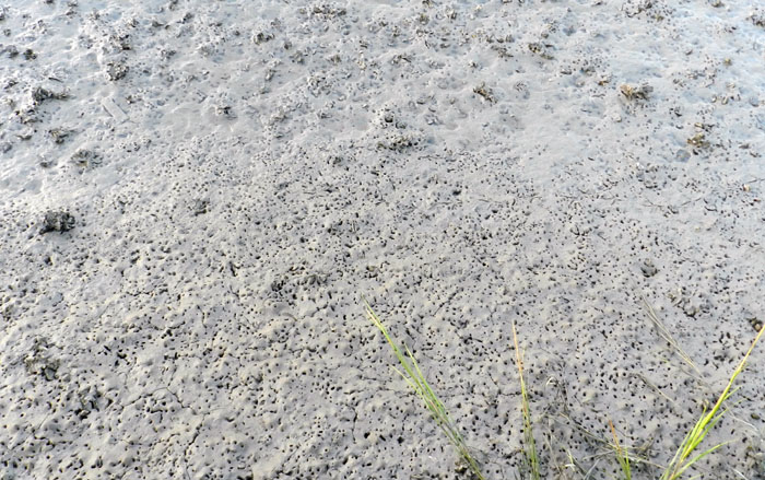
Each and every one of these holes is the burrow of a small marine-adapted animal – fiddler crabs, polychaete worms, and more. In other words, an ichnologist’s dream come true. (Photos by Anthony Martin.)

Less than a hundred meters from this dock is the home of Craig and Diana Barrow. Mr. Barrow is the ninth-generation heir of Wormsloe, but donated its grounds to the state of Georgia so that it could become a natural laboratory for researchers studying its environmental history. Ruth and I were acquainted with the Barrows from two previous visits to Wormsloe, and Craig – a great outdoors enthusiast – had eagerly given us personal tours of the woods, fields, and marshes on the property.

Having hunted for most of his life, Craig is a good tracker, and we’ve had in-depth discussions on animal-track forms, trackway patterns, aging of tracks, scat, and related topics. I find these conversations refreshing. Academic hierarchies, journal articles, impact factors, grant amounts, and other dull concerns become meaningless when you’re in the field with experienced naturalists. Here are some traces. Let’s learn.

Thus as the dawn light started to illuminate the maritime forest, I was not surprised to see Craig already outside his home, and to have him enthusiastically invite me to hop onto a golf cart with him to go look for tracks. He had already been out earlier on one of the sandy roads near his house and spotted three red foxes, so he wanted to check on whether their tracks were there, too. Within minutes, we arrived at the spot where he saw the foxes, and we quickly confirmed his sighting by identifying their fresh tracks in the loose sand on the road.

That was also about when Craig asked me a question that I answered wrong at first, then corrected once I gathered more data. You know, like any good scientist should. His question was “What’s this?”, and he was referring to a thin, shallow, and meandering groove in the sand. “Beetle trackway,” I answered instantly, without looking too closely. Then I squatted to show him the tiny tracks that would be on each side of the groove, where I imagined the beetle had dragged its abdomen.

Worm-Trail-Wormsloe-4Oh look, a beetle trackway, and right next to the tracks of a red fox (Vulpes vulpes)! How exciting! Gee whiz, I gosh-darn love science! Isn’t it neat? Wait a minute: what’s that earthworm doing at the end of a beetle trackway? (Photo by Anthony Martin, taken at Wormsloe Historic Site.)

That’s when I realized there were no tracks on either side of the groove. This was a trail made by a legless animal. “Wait a minute, this isn’t from a beetle,” I said. “Maybe a worm?” And by “worm,” I meant earthworm, but my small amount of experience with identifying earthworm traces made me a little uncomfortable with elaborating further on that idea. After all, I didn’t want to appear too ignorant about such common animals, and ones I had written about in both my book and on this blog (Of Darwin, Earthworms, and Backyard Science and Darwin, Worm Grunters, and Menacing Moles).

Fortunately, an earthworm saved me from further embarrassment by having the decency to be at the end of one of these trails, moving and otherwise actively demonstrating how these traces had been made. With our eyes and brains properly (and instantly) trained by this association between trace and tracemaker, Craig and I glanced around us. We were rewarded for looking, and promptly became astonished. The road was criss-crossed with hundreds of earthworm trails for as far as we could see, and most of them had living worms at their ends.

Even better, a few of these trails connected to open, small-diameter vertical burrows. My second insect-biased mistake of the morning was to initially identify these burrows as the shafts of halictid bee burrows. However, too many earthworm trails connected directly to these holes. Again, like any good scientist should in the face of contradictory evidence, I changed my mind. These traces were also from earthworms, and showed where the earthworms exited their subterranean homes.

Vertical-Burrow-Worm-Wormsloe
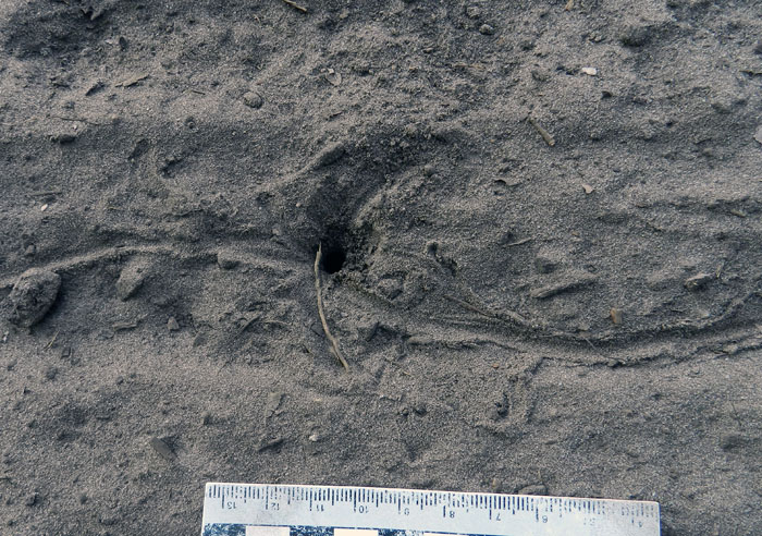
Earthworm burrow marking exactly where it left its home for the surface world, and intersecting a trail. (Photo by Anthony Martin, taken at Wormsloe Historic Site.)

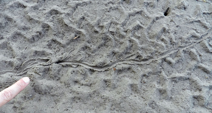
What really surprised me, though, was the length and complexity of the trails. These were not simple meandering paths, but complicated records of earthworm decision making. These worms may have been slow, but their traces certainly weren’t dull.

Worm-Trail-Wormsloe-2
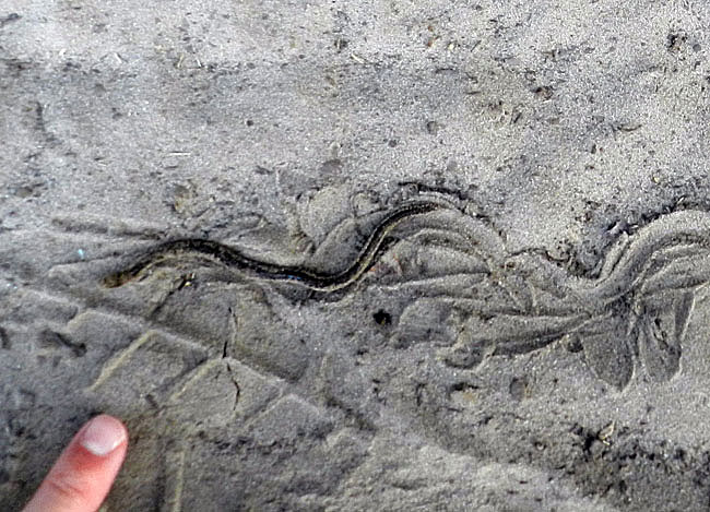
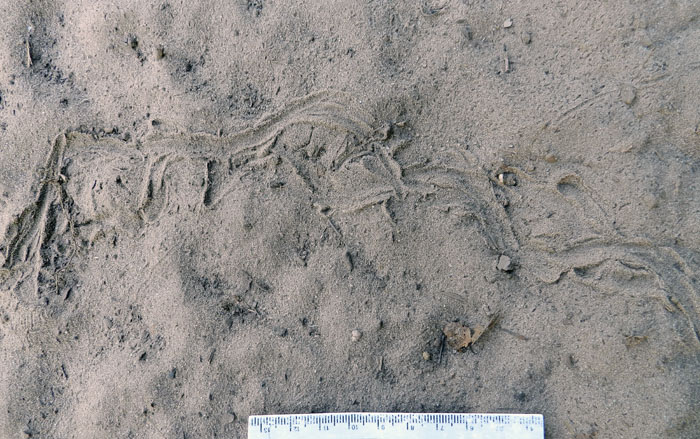
This trail was made by one earthworm that moved from right to left. The pointed grooves on either side of the main trail are from where its “head” and “tail” ends probed the sand.

Worm-Turning-Wormsloe-1Here’s an earthworm in action, moving from right to left. Compare this to the next photo to see how movement of both its forward and rear ends changes the trail, putting newer traces on top of the previously made ones.

Worm-Turning-Wormsloe-2
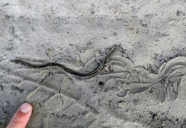
See what I mean? Small but multiple movements from both ends of a worm – as well as its middle – make this much, much more than just a “worm trail.” So don’t be calling it that. (Photos by Anthony Martin, taken at Wormsloe Historic Site.)

Yes, I know, there’s a bigger question that looms over all of this ichnological minutiae: Why were so many worms on top of the ground, instead of in it? What could have caused hundreds of them to leave their homes and risk the perils of dehydration and predation at the surface?

I speculated aloud that their mass stranding might have been related to vibrations imparted to the road. After all, Charles Darwin had noted how earthworms reacted like this to subsurface vibrations, associating these with their mortal enemies, burrowing moles. This was independently verified by “worm grunters” of the Appalachians, who took advantage of earthworm-mole co-evolution to get bait for their fishing. Craig backed up my idea by saying that he had grated the road the previous day. So perhaps the vibrations from his vehicle and activities had persuaded the earthworms to come up and out of the ground.

Later, though, I wondered whether another much larger stimulus had invoked such aversive reactions in the earthworms, one that persisted for more than a day after the road had been grated. What else could have done this, impelling these earthworms to flee, much like urban hipsters sensing the first few notes of a nearby Justin Bieber concert, and leaving spilled PBR’s in their wake?

Then it came to me. A full moon that weekend had caused higher tides than normal in the area, ranging from 2.6 to 2.9 m (8.5-9.6 ft). As a result, saltwater probably crept high enough in the soil profile to trigger a collective reaction in the earthworms, which do not fare well once salty water starts filling their homes. Yes, that would do it.

Salt-Marsh-Wormsloe
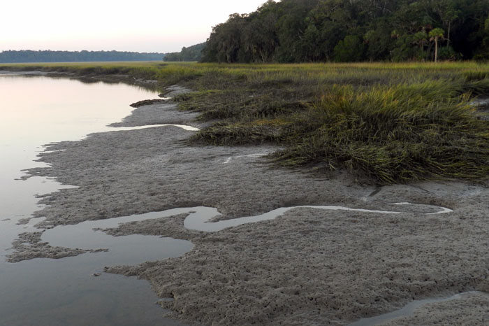
Hi, terrestrial earthworms. Remember me? I’m a salt marsh with 2.5-3 m high tides, right next to where you live.

Assuming this hypothesis is correct, what we saw there on that sandy road of Wormsloe Historic site was a great example of a marine ecosystem forcing animals living in a terrestrial ecosystem to drastically change their behaviors. Best of all, these animals made a suite of traces that reflected this sudden change in their behaviors. If preserved in the fossil record, such trails and burrows might even be recognizable to geologists and paleontologists, some of whom are quite fond of calling every invertebrate trace fossil a “worm burrow” anyway.

All in all, this field experience at Wormsloe taught me a lesson about keeping my senses open to noticing and wondering about traces wherever I go, as should you, gentle readers. Look for those moments when the worm has turned: they will teach you something new.

Worm-Trail-Wormsloe-1

Tracking the Wild Horses of Cumberland Island

(The following post is one of a series about traces of important invasive species of mammals on the Georgia barrier islands and the ecological effects of these traces. An introduction to this topic from last week is here.)

Perhaps the most charismatic yet problematic of non-native animals on any of the Georgia barrier islands are the wild horses (Equus caballus) of Cumberland Island. These horses are the source of much controversy, which becomes even more apparent whenever anyone tries to apply some actual science to them. So I will talk about them here from my perspective as a paleontologist and geologist in the hope that this will add another dimension to what is often presented as a two-sided and emotional argument.

Ah, the wild horses of Cumberland Island, Georgia, roaming free since the time of the Spanish in a pristine, unspoiled landscape, grazing contently on the sea oats and strolling through the coastal dunes, in perfect harmony with nature. How much of the preceding sentence is wrong? Almost all of it. If you want to find out why, please read on. But if your mind is already made up about the feral horses of Cumberland and you don’t want to hear anything bad said about them, then you might like this site. (Photograph by Anthony Martin.)

Cumberland Island, much of which is part of the U.S. National Park system as a National Seashore, is the only Georgia barrier island with a population of feral horses. Nevertheless, despite their uniqueness and fame – the latter figuring as key attractions in advertisements about Cumberland and inspiring dreamy book titles – their origins remain murky. One of the recurring romanticized claims is that these horses descended from livestock brought there by Spanish expeditions in the 16th century. This idea is reassuring to the people who repeat it for two reasons:

(1) It establishes horses as living in the landscape for a long time (especially by American standards), meaning that their presence there now is considered “natural.”

(2) It lends itself to the comforting thought that the horses connect to a European cultural heritage, putting an Old World imprint on a New World place.

However, once said enough times, such just-so stories become faith-based and any evidence contradicting them is not tolerated. Thus even when genetic studies of the Cumberland horses show they are not appreciably different from populations of horses on other islands of the eastern U.S. (arguing against a purely Spanish origin), any questioning of the stated premise – in my experience – provokes angry responses from its defenders.

I suspect this virulent reaction is a direct result of challenging both the “naturalness” and “cultural heritage” of the horses on Cumberland. In reality, though, these are opposing values. After all, an admission that these feral horses came from European stock at any point during the past 500 years supports how they clearly do not belong on Cumberland Island, or anywhere else in the Western Hemisphere if we’re talking about the last 10,000 years or so. In other words, the point is moot whether the current horse population originated in the 16th, 17th, 18th, 19th, or 20th century, or is a mixture of older and newer stock. If only horses could talk, then we would know for sure. (A detailed history of the horses on Cumberland Island is provided here for anyone interested in learning more about this.)

Arguments of heritage aside, these horses are newcomers in a geological and ecological sense. The fossil record of the modern Georgia barrier islands backs this up, as some of the islands (including Cumberland) have sediments more than 40,000 years old, but none have body or trace fossils of horses, or anything like a horse. Although three species of horses were living on the mainland part of North America during the Pleistocene Epoch until their respective extinctions more than 10,000 years ago, none were known to have inhabited any of the barrier islands, Pleistocene or recent. The closest ancient analogue to horses on any of the Georgia barrier islands would have been bison (Bison bison), but their bones are rare. This scarcity leads paleontologists to wonder whether the islands ever had self-sustaining populations of large herbivores.

So with all of that human history and pre-history in mind, the traces made by the feral horses of Cumberland and their ecological effects are exceptional to it and every other Georgia barrier island, and hence worth our attention. Just to keep this simple, I will cover three primary types of traces made by these horses. What these traces all have in common (other than being made by a horse, of course) is the decidedly negative impacts these have on the native plants and animals of Cumberland, including keystone species in the oft-labeled “pristine” ecosystems of the island.

Tracks and trails – These traces are the abundant and easily spotted on Cumberland, even to someone with little or no training in ichnology. Horses are unguligrade, which means they are walking on their toenails (unguals), and the ungual (more popularly called a hoof) is on a single digit. Hooves make circular to slightly oval compression shapes, but if preserved in the right substrate – like a firm mud or fine sand – they will show a “Pac-Man”-like form. Front-foot (manus) tracks are slightly larger than rear-foot (pes) tracks; manus impressions are 11-14 cm (4.3-5.5 in) long and 10-13 cm (4-5.1 in) wide, whereas pes impressions are 11-13 cm (4.3-5.1 in) long and 9-12 cm (3.5-4.7 in) wide, with variations in size depending on ages of the horses making the tracks.

Trackway of feral horse moving through the coastal dunes of Cumberland Island. Note the diagonal walking pattern and how front- and rear-foot impressions merge to make oblong compound traces.

An important point to keep in mind when tracking horses or any other hoofed animals is that their feet readily cut through sediments and vegetation, leaving much more sharply defined and deeper impressions than padded feet of an equivalent-sized animal. Because Georgia-coast sands contain whitish quartz and darker heavy minerals, these contrasting sand colors help to outline horse tracks on surfaces and in cross-section as deep and sharply defined structures that cut across the bedding.

When asked to think about horses in motion, it might be tempting to imagine them galloping, especially along a beach at sunset. Nonetheless, a horse would tire quickly if it galloped all day, especially for no valid reason. Instead, its normal gait is a slow walk, which causes the rear foot to register partially on top of the front-foot impression, but slightly behind; with a slightly faster walk, the rear foot will exceed the front-foot impression. The overall trackway pattern then is what many trackers call “diagonal-walking,” as the right-left-right alternation of steps can be linked with imaginary diagonal lines. Trackway width, also known as straddle, is about 20-40 cm (8-16 in) if a horse was just walking normally, but narrows noticeably once it starts picking up speed.

Feral-horse tracks on Cumberland Island, a close-up of the same trackway shown in the previous photo. This one was likely doing a slow walk, with indirect register of the rear foot just behind and onto the front-foot impression. The scale (my shoe) is a size 8½ mens. (Photograph by Anthony Martin.)

Given enough back-and-forth movement along preferred paths, repeating and overlapping trackways result in trails, which can be picked out as linear bare patches of exposed sand or mud cutting through vegetation. Because horses are much larger than the native white-tailed deer (Odocoileus virginianus) on Cumberland, their trails are considerably wider.

Feral-horse trail along the edge of a low salt marsh where they have trampled and overgrazed the smooth cordgrass in that marsh (Spartina alterniflora). (Photograph by Anthony Martin, taken on Cumberland Island.)

Chew marks – Horses are grazers and low-level browsers, and they eat a wide variety of vegetation on Cumberland. The most important plant species they eat through grazing are smooth cordgrass (Spartina alterniflora), sea oats (Uniola paniculata), and live oak (Quercus virginiana).  All three of these plants are keystone species in their respective ecosystems: smooth cordgrass predominates in the low salt marshes, sea oats are the mainstay plants of coastal dunes, and live oaks are the largest and most long-lived trees in the maritime forests. Their effects of horses consuming  smooth cordgrass and sea oats is straightforward, as these plants hold in sediments in place keep them from eroding, but how do horses affect live oaks? They eat the seedlings, which means that older oaks are being replaced by younger ones at a slower rate.

Grazing traces consist of clean cuts of vegetation within a vertical swath and over a broad area. Horses, unlike white-tailed deer, have teeth on both their upper and lower jaws, thus they shear plants on the branches, stems, or leaves. In contrast, deer leave more ragged marks, as they only have teeth on their lower jaws and hence have to pull on vegetation to break it off. Horses also can make a browse line, which is an abrupt horizontal line of decreased vegetation at a certain consistent height that more-or-less correlates with the average head height of the horses.

Dung – During any given stroll on Cumberland, you cannot avoid seeing, smelling, and stepping in horse feces. This abundance of fecal material means that the feces are not being recycled quickly enough into the ecosystems, which implies that native populations of dung beetles are overwhelmed by such abundance. I have seen a few traces of dung beetles in fresh piles of feces, but no matter how hard I have looked, I have yet to witness great thundering herds of beetles rolling balls of dung across the Cumberland Island landscape.

An impressive collection of horse dung, which was probably dropped by a single horse. Note the small holes in the middle, which were likely made by dung beetles that tunneled into this rich supply of food for their offspring.

Close-up of those probable dung-beetle burrows, some with short trails attached. The white quartz sand sprinkled on top shows how it was pulled up by beetles from underneath the dung pile and onto the top surface, thus giving a minimum depth of the burrows. (Both photographs by Anthony Martin, taken on Cumberland Island.)

One of the more interesting ecological consequences of horse dung I have seen on Cumberland is how it influences the behavior of smaller animals as pellets or piles form a microtopography. For example, on some of the dunes near Lake Whitney on Cumberland – the largest body of fresh water on any of the Georgia barrier islands – I was surprised to see that small lizards – probably skinks – were moving around the dung piles or burrowing under them.

Horse droppings as a part of the landscape for small lizards. Here their tracks, accompanied by tail dragmarks, wind around partially buried feces in a sand dune. (Photograph by Anthony Martin, taken on Cumberland Island.)

Small lizard burrow entrance immediately below a horse pellet, showing its use as a sort of roof. This could probably inspire some clever statement on shingles and, well, you know, but I’ll refrain for now. (Photograph by Anthony Martin, taken on Cumberland Island.)

All three categories of traces – tracks, chew marks, and dung – can be found together in ecosystems wherever horses are trampling, grazing, and defecating, respectively.

So now let’s put on our paleontologist or geologist hats (not to be confused with archaeologist hats) and ask ourselves about the likelihood of such traces making it into the fossil record, and how we would recognize them if they did. Their likelihood of preservation, in order, would be tracks, feces, and chew marks. Tracks would be evident as large compression shapes in horizontal bedding planes or deep disruptions of bedding planes in vertical section. Feces, or their fossil versions called coprolites, might get preserved, although herbivore feces, filled with vegetative material, is less likely to make it into the fossil record compared to carnivore feces, which may have lots of bone material in it. The last of these – chew marks – would be nearly impossible to tell from normal tearing and other degradation of plant material before it became fossilized. Good luck on that.

But could the ecological damage caused by an invasive species, in which the introduction of a species serve as a sort of trace fossil in itself? In the case of horses or ecologically similar animals, subtle changes to the landscape over time might take place. This experiment actually has been done on Assateauge Island (North Carolina), which also has a feral horse population. In areas where horses were excluded by fences, the dunes were on average 0.6 meters (2 ft) feet higher than those of overgrazed and trampled dunes. Geologists conducted another study done on Shackleford Banks (North Carolina) in which they examined areas where fences had separated non-horse from horse-occupied parts of the island. These geologists similarly found that horses caused dunes to be less than 1.5 m (5 ft) high, whereas dunes without horses were as much as 3.5 m (11.5 ft) high. This meant that storms more easily penetrated the barriers provided by coastal dunes, more commonly resulting in storm-washover fans.

This change in the coastal geology of back-dune areas also means that ground-nesting shorebirds will become less common, as their nests and nestlings will be drowned or buried more frequently. Horses also are known to step on shorebird eggs and nests, or can scare away parents from nests, which increases the likelihood of egg or nest predators taking out the next generation of shorebirds.

If any horses made it to the Georgia barrier islands during the Pleistocene and established breeding populations, a geologic sequence following their arrival would look like this, from bottom to top: high dunes suffused with root traces (before horses); lower dunes corresponding with fewer root traces and deep disruptions of bedding (horse tracks); increased numbers of storm-washover fans; and a high salt-marsh. In short, a geologist would see an overall progression from a dune-dominated shoreline to a high salt marsh. Similarly, a paleontologist might see a decrease in root trace fossils and shorebird nests, eggshells, and tracks, possibly culminating in local extinctions of each.

This is your Georgia coast.

This is your Georgia coast with horses. Any questions?

Top panorama is of high-amplitude coastal dunes and well-vegetated back-dune meadows on Sapelo Island, whereas the bottom panorama is of low-amplitude dunes with no appreciable back-dune meadows on Cumberland Island. (Both panoramas based on photos taken by Anthony Martin.)

Based on what we know then, should the feral horses of Cumberland Island be removed? Yes. Will they be removed? Probably not. However, regardless of happens, I will keep teaching about the horses of Cumberland Island and their traces, both as an educator and a concerned citizen. Perhaps with enough awareness, circumstances will change for the better so that Cumberland Island can not only remain a beautiful place, but also will become more like what it was before the arrival of horses there.

(Next week in this series about invasive mammal species of the Georgia barrier islands and their traces, I’ll cover a less inflammatory but still intriguing topic: the feral cattle of Sapleo Island.)

Further Reading

Buynevich, I.V., Darrow, J.S., Grimes, T.A.Z., Seminack, C.T., and Griffis, N. 2011. Ungulate tracks in coastal sands: recognition and sedimentological significance. Journal of Coastal Research, Special Issue 64: 334-338.

De Stoppalaire, G.H., Gillespie, T.W., Brock, J.C., and Tobin, G.A. 2004. Use of remote sensing techniques to determine the effects of grazing on vegetation cover and dune elevation at Assateague Island National Seashore: impact of horses. Environmental Management, 34: 642-649.

Dilsaver, L.M. 2004. Cumberland Island National Seashore: A History of Conservation Conflict. University of Virginia Press, Charlottesville, Virginia: 304 p.

Elbroch, M. 2003. Mammal Tracks and Sign: A Guide to North American Species. Stackpole Books, Mechanicsburg, Pennsylvania: 779 p.

Goodloe, R.B., Warren, R.J., Osborn, D.A., and Hall, C. 2000. Population characteristics of feral horses on Cumberland Island and their management implications. The Journal of Wildlife Management, 64: 114-121.

Sabine, J.B., Schweitzer, S.H., and Meyers, J.M. 2006. Nest Fate and Productivity of American Oystercatchers, Cumberland Island National Seashore, Georgia. Waterbirds, 29: 308-314.

Turner, M.G. 1987. Effects of grazing by feral horses, clipping, trampling, and burning on a Georgia salt marsh. Estuaries and Coasts, 10: 54-60.

Turner, M.G. 1988. Simulation and management implications of feral horse grazing on Cumberland Island, Georgia. Journal of Range Management, 41: 441-447.